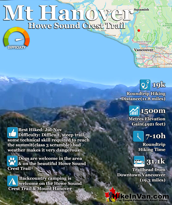
![]() Mount Hanover is another amazing and accessible peak in the North Shore mountains. Located in the beautiful Cypress Provincial Park, Mount Hanover is among several other prominent summits on the amazing Howe Sound Crest Trail. You can reach Mount Hanover from the Howe Sound Crest Trail if you begin your hike from the Cypress Mountain Resort, however reaching it from the trailhead in Lions Bay is much shorter.
Mount Hanover is another amazing and accessible peak in the North Shore mountains. Located in the beautiful Cypress Provincial Park, Mount Hanover is among several other prominent summits on the amazing Howe Sound Crest Trail. You can reach Mount Hanover from the Howe Sound Crest Trail if you begin your hike from the Cypress Mountain Resort, however reaching it from the trailhead in Lions Bay is much shorter.
 Off the Howe Sound Crest Trail
- Very challenging & rewarding hike
- Stunning views from the summit
- Likely have the mountain to yourself
- Brunswick Lake is fairly close
- Camping is free & amazing
- The HSCT is dog friendly
 Too challenging for most hikers
- Parking is hopelessly inadequate
- Poor weather makes it dangerous
Vancouver Hiking Trails
![]() Black Mountain
Black Mountain ![]() Brunswick Mountain
Brunswick Mountain ![]() Burnaby Lake
Burnaby Lake ![]() Burnaby Mountain
Burnaby Mountain ![]() Coliseum Mountain
Coliseum Mountain ![]() Crown Mountain
Crown Mountain ![]() Cypress Falls
Cypress Falls ![]() Deeks Peak
Deeks Peak ![]() Deep Cove
Deep Cove ![]() Deer Lake
Deer Lake ![]() Dog Mountain
Dog Mountain ![]() Goat Mountain
Goat Mountain ![]() Goldie Lake
Goldie Lake ![]() Grouse
Grouse ![]() Hollyburn Mountain
Hollyburn Mountain ![]() Kitsilano Beaches
Kitsilano Beaches ![]() Lighthouse Park
Lighthouse Park ![]() Lynn Canyon
Lynn Canyon ![]() Lynn Peak
Lynn Peak ![]() Mt Elsay
Mt Elsay ![]() Mt Fromme
Mt Fromme ![]() Mt Hanover
Mt Hanover ![]() Mt Harvey
Mt Harvey ![]() Mt Seymour
Mt Seymour ![]() Mt Strachan
Mt Strachan ![]() Mystery Lake
Mystery Lake ![]() Pacific Spirit
Pacific Spirit ![]() Rice Lake
Rice Lake ![]() St Mark's
St Mark's ![]() Stanley Park
Stanley Park ![]() The Lions
The Lions ![]() Unnecessary
Unnecessary
This trailhead is also used to reach The Lions, Mount Harvey and Brunswick Mountain. There is no established route to Hanover after you leave the Howe Sound Crest Trail. Fortunately Hanover towers visibly in the distance at all times, so the best method to reach the summit is to route find your way as you go. This of course makes Mount Hanover a potentially dangerous hike if you are unprepared or unlucky with the weather.
Be sure to have a GPS and topo map with you and know what you are doing. The route to the Howe Sound Crest Trail from the Lions Bay trailhead(Lions Binkert trailhead) is the same as the route you would take to Brunswick Mountain so it is well marked with flagging tape though there are few written signs. The trail is challenging as you gain considerable elevation in a short distance, 1550 metres in just 7.3 kilometres.
The first half of the trail is fairly easy as you follow first a disused logging road for about 15 minutes (bear right at a fork), then a wide and fairly straight trail for another 20 minutes until you reach another junction. Take the trail (overgrown logging road) to the left which is well marked with flagging tape. You will shortly cross Magnesia Creek and the trail steepens as the logging road/trail becomes a trail and soon you will see a fork.
Take the fork to the right and soon you will come to the Howe Sound Crest Trail. From here you must route find your way to the very visible Mount Hanover. Mount Hanover is part of the amazing Howe Sound Crest Trail in Cypress Provincial Park and is one of the many beautiful peaks to be climbed if desired on the 29 kilometre trail. Among the hiker friendly mountains (in order from Cypress north) on the Howe Sound Crest Trail are: Mount Strachan, St Mark`s Summit, Unnecessary Mountain, The Lions, Mount Harvey, Mount Hanover, Brunswick Mountain and finally Deeks Peak.
Discover Mount Hanover at HikeInVan.com

Best Whistler & Garibaldi Park Hiking Trails!
Whistler & Garibaldi Park Hiking by Month!


Explore BC Hiking Destinations!

Whistler Hiking Trails

Squamish Hiking Trails

Vancouver Hiking Trails

Clayoquot Hiking Trails
Victoria Hiking Trails

