![]() Cheakamus River is a beautiful, crashing, turquoise coloured river that flows from Cheakamus Lake, through Whistler Interpretive Forest at Cheakamus Crossing, then down past Brandywine Falls to Daisy Lake. Also a popular kayaking route, the main attraction to Cheakamus River is the wonderful and quite extensive network of trails that run along either side of it. The Riverside trail and the Farside trail hug both sided of Cheakamus River and connect at both ends by bridges.
Cheakamus River is a beautiful, crashing, turquoise coloured river that flows from Cheakamus Lake, through Whistler Interpretive Forest at Cheakamus Crossing, then down past Brandywine Falls to Daisy Lake. Also a popular kayaking route, the main attraction to Cheakamus River is the wonderful and quite extensive network of trails that run along either side of it. The Riverside trail and the Farside trail hug both sided of Cheakamus River and connect at both ends by bridges.
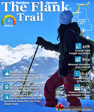
 Better than Lost Lake and free!
- Bus stop close to the trailhead
- Snowshoe to Logger's Lake in a volcano!
- Wonderfully wild & dog friendly
- Easy & family friendly snowshoeing
- Many great sights & viewpoints
- Serene wilderness & little elevation change!
 Heavy construction reducing access
- Easy to get lost in the maze of trails
- Camping prohibited
Whistler Snowshoe Trails
![]() Blueberry Trail
Blueberry Trail ![]() Brandywine Falls
Brandywine Falls ![]() Cheakamus River
Cheakamus River ![]() Elfin Lakes
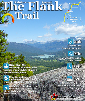
Elfin Lakes ![]() Flank Trail
Flank Trail ![]() Joffre Lakes
Joffre Lakes ![]() Nairn Falls
Nairn Falls ![]() Parkhurst Ghost Town
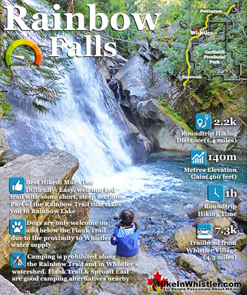
Parkhurst Ghost Town ![]() Rainbow Falls
Rainbow Falls ![]() Rainbow Lake
Rainbow Lake ![]() Rainbow Park
Rainbow Park ![]() Sproatt East
Sproatt East ![]() Taylor Meadows
Taylor Meadows ![]() Train Wreck
Train Wreck ![]() Wedgemount Lake
Wedgemount Lake
![]() January
January ![]() February
February ![]() March
March ![]() April
April ![]() May
May ![]() June
June ![]() July
July ![]() August
August ![]() September
September ![]() October
October ![]() November
November ![]() December
December
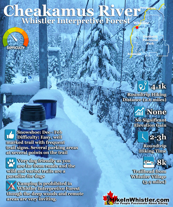
Connecting to the Riverside trail is the short trail to Logger's Lake, which in turn is surrounded by more snowshoe trails. The Lake Loop trail, Crater Rim trail, the Ridge trail, Upper Ridge trail, and the Lower Ridge trail. On the Farside trail along Cheakamus River you can connect to Cheakamus Road(gravel road) and hike 6 kilometres up to the Cheakamus Lake trailhead. On the other side of the neighbourhood of Cheakamus Crossing, which Cheakamus River bends around keeping the Sea to Sky Highway and train tracks on its opposite side, you find still more snowshoe trails. Trash trail hugs the river all the way to the beautiful bridge to Whistler Train Wreck. Or, continue past the bridge to connect with the Sea to Sky trail. For the most part, however, if you are talking about the Cheakamus River trails you are likely talking about the Farside and Riverside trails in Whistler's Interpretive Forest. Eight kilometres south of Whistler Village and surrounding the neighbourhood of Cheakamus Crossing is Whistler Interpretive Forest. This beautiful forest surrounds the Cheakamus River and has been cut and replanted in several areas in the past decades. Hiking and biking trails have sprung up over the years making the area a wonderful place to explore. Unfortunately, the Interpretive Forest is day-use only, no camping is permitted. The main highlights of the Interpretive Forest are the Cheakamus River trails, and the extraordinary Logger's Lake. Logger's Lake, just a short hike from the Cheakamus River suspension bridge, sits within a 10000 year old, extinct volcano and is a hiking destination on its own.
Snowshoeing the Cheakamus River Trails
![]() Cheakamus River is located just 8km south of Whistler Village just off of the Sea to Sky Highway. This well marked, though beautifully remote feeling snowshoeing trail takes you along both sides of the wildly crashing Cheakamus River. Snow begins to fall in earnest in the Whistler area in November, so the best months for snowshoeing Cheakamus River are from late November to early April. These trails are frequently used year-round so the snow on the trail is often packed down. You may find that you don't need snowshoes for much or all of the trail. One of the best routes is to walk/snowshoe from your car for about 100 metres following the road to Cheakamus Lake. At about 100 metres you will see a branching road go to the right and a large, vehicle bridge cross the Cheakamus River. Cross the bridge and you will immediately see a trail on your left running along the river. This trail, with Cheakamus River on your left will descend and ascend through a beautiful forest. Sometimes close to the river, sometimes 100 metres away.
Cheakamus River is located just 8km south of Whistler Village just off of the Sea to Sky Highway. This well marked, though beautifully remote feeling snowshoeing trail takes you along both sides of the wildly crashing Cheakamus River. Snow begins to fall in earnest in the Whistler area in November, so the best months for snowshoeing Cheakamus River are from late November to early April. These trails are frequently used year-round so the snow on the trail is often packed down. You may find that you don't need snowshoes for much or all of the trail. One of the best routes is to walk/snowshoe from your car for about 100 metres following the road to Cheakamus Lake. At about 100 metres you will see a branching road go to the right and a large, vehicle bridge cross the Cheakamus River. Cross the bridge and you will immediately see a trail on your left running along the river. This trail, with Cheakamus River on your left will descend and ascend through a beautiful forest. Sometimes close to the river, sometimes 100 metres away.


Ridge Trail and Logger's Lake
Another very nice snowshoeing trail, the Ridge Trail, extends from the Cheakamus River trail. You can find it easily by several excellent trail signs at various junctures. The Ridge trail takes you up a and away from Cheakamus River to Logger’s Lake where you can go around Logger’s Lake, or just along one side before re-connecting to the Cheakamus River trail not far from the suspension bridge. As these trails are popular in the summer for hiking and biking they are well marked with signs. The Cheakamus River suspension bridge, which is 2k from where you parked and should take about an hour to reach. There are wide and straight logging roads on either side of the Cheakamus River which ensure that you can't get lost if you stray from the marked trails.

Beautiful Suspension Bridge Crossing
Once you reach the suspension bridge you can cross it and return to your car from the other side of the river. You will see a trail on the other side of the bridge on your left. You can also snowshoe back via the Cheakamus Lake Westside Road which is just a hundred metres or so from the bridge (after you cross it from the side you just snowshoed). As long as you keep within the bounds of the Cheakamus Lake Road and the Cheakamus River on your way back to your car you can pick your own route as the trails branch in and out in this confined area as it ascends back to your car and starting point. There are no facilities on the trail however in Cheakamus Crossing just a one minute drive past the trailhead you will see the large Hostel, the HI Whistler which has an amazing coffee shop where you can get a great selection of food and drinks and even a beer or glass of wine.

Cheakamus River Trail Map
![]() The Cheakamus River trails centre around two core trails that link via the Cheakamus River suspension bridge at one end and the Cheakamus Crossing bridge at the other. These two trails, Riverside & Farside, lay at the heart of Whistler Interpretive Forest, which encompasses the surrounding areas of beyond Cheakamus River. These areas consist of the Riverside trail, Farside trail, Discovery Loop, Ridge trail, Riparian Interpretive trail, Crater Rim trail, Craterview Loop, Plantation Loop, Biogeoclimatic Loop, Crater Lookout and more. The Riverside trail is an easy to moderate, 2 kilometre multi-use trail with a a few steep switchbacks and a couple very scenic viewpoints over the river. At the suspension bridge it connects to the Farside trail that hugs the opposite side of the river and brings you back to where you started in Cheakamus Crossing.
The Cheakamus River trails centre around two core trails that link via the Cheakamus River suspension bridge at one end and the Cheakamus Crossing bridge at the other. These two trails, Riverside & Farside, lay at the heart of Whistler Interpretive Forest, which encompasses the surrounding areas of beyond Cheakamus River. These areas consist of the Riverside trail, Farside trail, Discovery Loop, Ridge trail, Riparian Interpretive trail, Crater Rim trail, Craterview Loop, Plantation Loop, Biogeoclimatic Loop, Crater Lookout and more. The Riverside trail is an easy to moderate, 2 kilometre multi-use trail with a a few steep switchbacks and a couple very scenic viewpoints over the river. At the suspension bridge it connects to the Farside trail that hugs the opposite side of the river and brings you back to where you started in Cheakamus Crossing.

Facilities at Cheakamus River
![]() The Cheakamus River trails and the Interpretive Forest don't have a whole lot of facilities such as outhouses or picnic tables. This is quite nice as to maintain a wild and untouched feeling of the area. You will find an outhouse at Logger’s Lake and of course the nearby Cheakamus Crossing has a few eateries with washrooms. The HI Whistler Hostel has a very nice little coffee shop with a few things to eat and drink. It is worth checking out, not least for a glimpse at Athletes Village. The name given to this neighbourhood for the 2010 Olympics as it accommodated hundreds of athletes. The HI Whistler Hostel is a huge hostel and looks inside and out like a hotel. Very modern and trendy feeling as you walk in the front door. The only drawback to this hostel is its location, as it is 8 kilometres south of Whistler Village, though on a regular bus route.
The Cheakamus River trails and the Interpretive Forest don't have a whole lot of facilities such as outhouses or picnic tables. This is quite nice as to maintain a wild and untouched feeling of the area. You will find an outhouse at Logger’s Lake and of course the nearby Cheakamus Crossing has a few eateries with washrooms. The HI Whistler Hostel has a very nice little coffee shop with a few things to eat and drink. It is worth checking out, not least for a glimpse at Athletes Village. The name given to this neighbourhood for the 2010 Olympics as it accommodated hundreds of athletes. The HI Whistler Hostel is a huge hostel and looks inside and out like a hotel. Very modern and trendy feeling as you walk in the front door. The only drawback to this hostel is its location, as it is 8 kilometres south of Whistler Village, though on a regular bus route.

Restrictions and Concerns at Cheakamus River
![]()
![]()
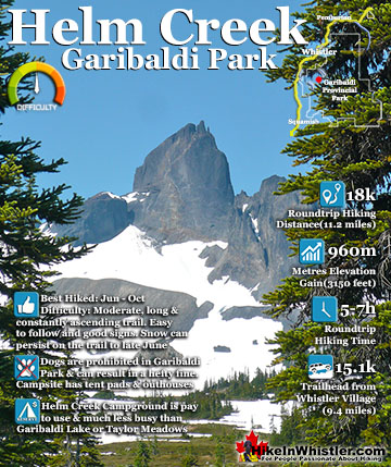
![]() No fires are allowed in Whistler's Interpretive Forest as the danger of forest fires is very high. No motorised vehicles on the trails either. Camping is not allowed, however the Interpretive Forest covers quite a large area of wilderness with dozens of idyllic places to sneak a nights sleep in the wilderness. For legal campsite options you have to look further up the Cheakamus Valley. Cheakamus Lake has two very nice, wilderness campsites(pay to use). Helm Creek campground is further up towards Black Tusk. These are both in Garibaldi Provincial Park, which is campsite friendly, but not dog or bike friendly. As mentioned above, the Cal-Cheak Campground and Whistler RV Park & Campground are good options for pay camping.
No fires are allowed in Whistler's Interpretive Forest as the danger of forest fires is very high. No motorised vehicles on the trails either. Camping is not allowed, however the Interpretive Forest covers quite a large area of wilderness with dozens of idyllic places to sneak a nights sleep in the wilderness. For legal campsite options you have to look further up the Cheakamus Valley. Cheakamus Lake has two very nice, wilderness campsites(pay to use). Helm Creek campground is further up towards Black Tusk. These are both in Garibaldi Provincial Park, which is campsite friendly, but not dog or bike friendly. As mentioned above, the Cal-Cheak Campground and Whistler RV Park & Campground are good options for pay camping.

Wildlife at Cheakamus River
![]() The chances of spotting a bear along Cheakamus River or anywhere in the Interpretive Forest are good, but only outside the winter months. If you drive, hike or bike up the 8 kilometre logging road to the Cheakamus Lake trailhead in the summer, you will pass numerous piles of bear dung. Often on this road you will encounter bears as well as on the trails. The encounters on the hiking/biking trails can be quite unnerving due to the windy trails causing you to encounter them at close range. There is no great danger for bears in Whistler unless you provoke them. Of course provoking a bear is as easy as having lots of food around and luring one toward you.
The chances of spotting a bear along Cheakamus River or anywhere in the Interpretive Forest are good, but only outside the winter months. If you drive, hike or bike up the 8 kilometre logging road to the Cheakamus Lake trailhead in the summer, you will pass numerous piles of bear dung. Often on this road you will encounter bears as well as on the trails. The encounters on the hiking/biking trails can be quite unnerving due to the windy trails causing you to encounter them at close range. There is no great danger for bears in Whistler unless you provoke them. Of course provoking a bear is as easy as having lots of food around and luring one toward you.
Parking & Trailhead Directions to Cheakamus River
![]()
![]()
![]() Parking for the Cheakamus River trails and Whistler's Interpretive Forest are numerous. The main Whistler Interpretive Forest parking lot is located just off the Sea to Sky Highway. Easy to spot and just metres from the highway. There is a bus stop very close to the parking lot, so it is convenient by bus as well. Biking to the Cheakamus River trails is very easy because the Sea to Sky trail and Whistler's Valley Trail system connects to Cheakamus Crossing from the Village. The route is very scenic and on a wide, two lane purpose build, multi-use trail. This trail actually cuts through the Interpretive Forest's parking lot. Other parking areas for Cheakamus River are mostly unmarked, but excellent and convenient. You can in fact park just steps from the suspension bridge over the river at the parking area, best for the short trek up to Logger's Lake. Cheakamus Crossing also has a nice and huge parking area that sits next to is the Ridge trail leading to Logger's Lake. In the winter, however, you will find the access roads on both sides of Cheakamus River buried in snow. Parking at the big Whistler Interpretive Forest parking lot just off the Sea to Sky Highway is a good idea. From there you just walk the beautiful Valley Trail for five minutes to reach the Cheakamus Lake Road on your left and quickly see the Cheakamus Crossing bridge. Here you can choose to snowshoe either side of Cheakamus River. Each side is similar with winding, beautiful trails, both two kilometres to reach the Cheakamus River suspension bridge. Another excellent place to park in the winter is found in Cheakamus Crossing at the end of Mount Fee Road. This huge parking lot is about a third of the way from the Cheakamus Crossing bridge and the Cheakamus River suspension bridge. It is also just a couple hundred metres from the Lower Ridge trailhead that takes you up to Logger’s Lake which you can then link back to Cheakamus River at the suspension bridge and snowshoe back to your car.
Parking for the Cheakamus River trails and Whistler's Interpretive Forest are numerous. The main Whistler Interpretive Forest parking lot is located just off the Sea to Sky Highway. Easy to spot and just metres from the highway. There is a bus stop very close to the parking lot, so it is convenient by bus as well. Biking to the Cheakamus River trails is very easy because the Sea to Sky trail and Whistler's Valley Trail system connects to Cheakamus Crossing from the Village. The route is very scenic and on a wide, two lane purpose build, multi-use trail. This trail actually cuts through the Interpretive Forest's parking lot. Other parking areas for Cheakamus River are mostly unmarked, but excellent and convenient. You can in fact park just steps from the suspension bridge over the river at the parking area, best for the short trek up to Logger's Lake. Cheakamus Crossing also has a nice and huge parking area that sits next to is the Ridge trail leading to Logger's Lake. In the winter, however, you will find the access roads on both sides of Cheakamus River buried in snow. Parking at the big Whistler Interpretive Forest parking lot just off the Sea to Sky Highway is a good idea. From there you just walk the beautiful Valley Trail for five minutes to reach the Cheakamus Lake Road on your left and quickly see the Cheakamus Crossing bridge. Here you can choose to snowshoe either side of Cheakamus River. Each side is similar with winding, beautiful trails, both two kilometres to reach the Cheakamus River suspension bridge. Another excellent place to park in the winter is found in Cheakamus Crossing at the end of Mount Fee Road. This huge parking lot is about a third of the way from the Cheakamus Crossing bridge and the Cheakamus River suspension bridge. It is also just a couple hundred metres from the Lower Ridge trailhead that takes you up to Logger’s Lake which you can then link back to Cheakamus River at the suspension bridge and snowshoe back to your car.

More Whistler Snowshoe Trails
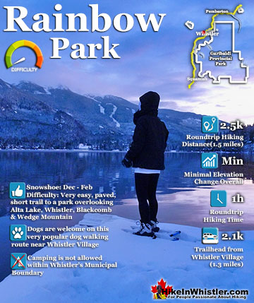
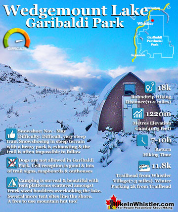
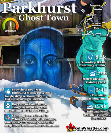
![]() There are plenty of beautiful and free snowshoe trails in Whistler and Garibaldi Provincial Park. From the surreal paintings of Whistler Train Wreck to the magnificent mountain serenity of Wedgemount Lake in Garibaldi Park. Trails range from extremely easy, like the short, flat trails to Brandywine Falls and Rainbow Park. To challenging and long trails to places like Elfin Lakes, Taylor Meadows and Wedgemount Lake. Whistler even has a growing network of snowshoe trails to Parkhurst Ghost Town on the far side of Green Lake. There are a couple pay-use snowshoeing areas in Whistler, however most free trails are as good or better. Whistler Train Wreck is an easy/moderate snowshoe trail that takes you through a deep forest, over Cheakamus River via a very pretty suspension bridge, and to a series of decades old, wrecked train cars. Elfin Lakes in Garibaldi Provincial Park is another beautiful place to snowshoe. Located at the south end of Garibaldi Park, the Elfin Lakes trailhead is found in Squamish. The trail is not overly difficult, however it is quite long. A consistently uphill, 11 kilometre(13.7 mile) trail through some spectacular scenery takes you to the Elfin Lakes hut. For easier snowshoeing, Rainbow Falls is a good option. Located just a short drive from Whistler Village, the Rainbow Trail is a beautiful trek through the forest in a winter wonderland to a hidden waterfall surrounded by deep pillows of powdery snow. For more challenging snowshoeing, Joffre Lakes Provincial Park is hard to beat. A long, though beautiful drive into the mountains, north of Pemberton takes you to this moderately challenging, 11 kilometre(6.8mile) roundtrip snowshoe trail. The frequently steep, winding trail takes you through a winter paradise and around, or over three frozen lakes. Back in Whistler, an excellent place to snowshoe is to Parkhurst Ghost Town. Sitting on the far side of Green Lake, Parkhurst was a thriving logging community several decades ago. It has since been abandoned except for intermittent squatter communities over the years.
There are plenty of beautiful and free snowshoe trails in Whistler and Garibaldi Provincial Park. From the surreal paintings of Whistler Train Wreck to the magnificent mountain serenity of Wedgemount Lake in Garibaldi Park. Trails range from extremely easy, like the short, flat trails to Brandywine Falls and Rainbow Park. To challenging and long trails to places like Elfin Lakes, Taylor Meadows and Wedgemount Lake. Whistler even has a growing network of snowshoe trails to Parkhurst Ghost Town on the far side of Green Lake. There are a couple pay-use snowshoeing areas in Whistler, however most free trails are as good or better. Whistler Train Wreck is an easy/moderate snowshoe trail that takes you through a deep forest, over Cheakamus River via a very pretty suspension bridge, and to a series of decades old, wrecked train cars. Elfin Lakes in Garibaldi Provincial Park is another beautiful place to snowshoe. Located at the south end of Garibaldi Park, the Elfin Lakes trailhead is found in Squamish. The trail is not overly difficult, however it is quite long. A consistently uphill, 11 kilometre(13.7 mile) trail through some spectacular scenery takes you to the Elfin Lakes hut. For easier snowshoeing, Rainbow Falls is a good option. Located just a short drive from Whistler Village, the Rainbow Trail is a beautiful trek through the forest in a winter wonderland to a hidden waterfall surrounded by deep pillows of powdery snow. For more challenging snowshoeing, Joffre Lakes Provincial Park is hard to beat. A long, though beautiful drive into the mountains, north of Pemberton takes you to this moderately challenging, 11 kilometre(6.8mile) roundtrip snowshoe trail. The frequently steep, winding trail takes you through a winter paradise and around, or over three frozen lakes. Back in Whistler, an excellent place to snowshoe is to Parkhurst Ghost Town. Sitting on the far side of Green Lake, Parkhurst was a thriving logging community several decades ago. It has since been abandoned except for intermittent squatter communities over the years.

More Whistler & Garibaldi Park Snowshoe Trails!
Where to Hike in Whistler & Garibaldi Park by Month


Amazing Whistler & Garibaldi Park Hiking Trails!