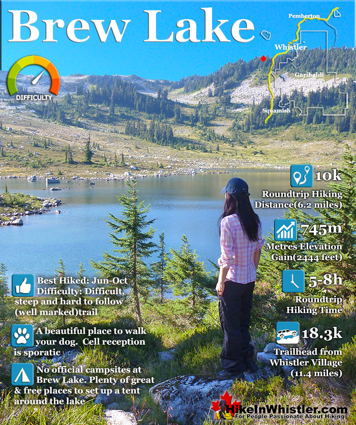
![]() Brew Lake is beautiful mountain lake just a short drive south of Whistler and is relatively unknown and seldom hiked. Laying at the base of Mount Brew, Brew Lake lays in a massive alpine valley of enormous erratics. On first seeing Brew Lake it looks serene, yet wild and hostile. The lake is surrounded on one side by idyllic tree covered hills and lakeside cliffs and on the other side a brutal looking wasteland of huge boulders sloping up to the sky.
Brew Lake is beautiful mountain lake just a short drive south of Whistler and is relatively unknown and seldom hiked. Laying at the base of Mount Brew, Brew Lake lays in a massive alpine valley of enormous erratics. On first seeing Brew Lake it looks serene, yet wild and hostile. The lake is surrounded on one side by idyllic tree covered hills and lakeside cliffs and on the other side a brutal looking wasteland of huge boulders sloping up to the sky.


 Very off the radar, wild & infrequently hiked
- Stunning, dramatic boulder field & windswept trees
- Lots of excellent places to put your tent
- Not as cold to swim as Joffre, Wedge, Garibaldi
- Hut on Mount Brew is a surreal little oasis
- Beautiful views of Black Tusk & Daisy Lake
 Tricky to find trailhead & tough, steep trail
- Lake is not stunning like Joffre, Wedge, Garibaldi
- Snow restricts access well into June
- Trail is only 5k, but feels like 10k!
Whistler & Garibaldi Hiking
![]() Alexander Falls
Alexander Falls ![]() Ancient Cedars
Ancient Cedars ![]() Black Tusk
Black Tusk ![]() Blackcomb Mountain
Blackcomb Mountain ![]() Brandywine Falls
Brandywine Falls ![]() Brandywine Meadows
Brandywine Meadows ![]() Brew Lake
Brew Lake ![]() Callaghan Lake
Callaghan Lake ![]() Cheakamus Lake
Cheakamus Lake ![]() Cheakamus River
Cheakamus River ![]() Cirque Lake
Cirque Lake ![]() Flank Trail
Flank Trail ![]() Garibaldi Lake
Garibaldi Lake ![]() Garibaldi Park
Garibaldi Park ![]() Helm Creek
Helm Creek ![]() Jane Lakes
Jane Lakes ![]() Joffre Lakes
Joffre Lakes ![]() Keyhole Hot Springs
Keyhole Hot Springs ![]() Logger’s Lake
Logger’s Lake ![]() Madeley Lake
Madeley Lake ![]() Meager Hot Springs
Meager Hot Springs ![]() Nairn Falls
Nairn Falls ![]() Newt Lake
Newt Lake ![]() Panorama Ridge
Panorama Ridge ![]() Parkhurst Ghost Town
Parkhurst Ghost Town ![]() Rainbow Falls
Rainbow Falls ![]() Rainbow Lake
Rainbow Lake ![]() Ring Lake
Ring Lake ![]() Russet Lake
Russet Lake ![]() Sea to Sky Trail
Sea to Sky Trail ![]() Skookumchuck Hot Springs
Skookumchuck Hot Springs ![]() Sloquet Hot Springs
Sloquet Hot Springs ![]() Sproatt East
Sproatt East ![]() Sproatt West
Sproatt West ![]() Taylor Meadows
Taylor Meadows ![]() Train Wreck
Train Wreck ![]() Wedgemount Lake
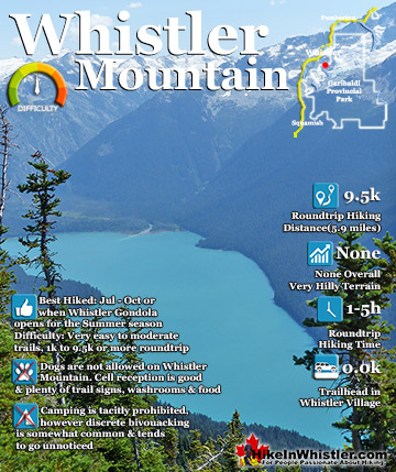
Wedgemount Lake ![]() Whistler Mountain
Whistler Mountain
![]() January
January ![]() February
February ![]() March
March ![]() April
April ![]() May
May ![]() June
June ![]() July
July ![]() August
August ![]() September
September ![]() October
October ![]() November
November ![]() December
December
Hiking into this wasteland of erratics reveals an amazing paradise of small, island forests, cute streams and endless worlds within worlds to explore. You find yourself wandering along like a kid mesmerized at what you will find next. Brew Lake itself doesn't come close in wow factor to the postcard-perfect alpine lakes such as Wedgemount Lake, Joffre Lakes, Cheakamus Lake or Garibaldi Lake, but I does beat these lakes in other aspects. Because Brew Lake is outside of Garibaldi Provincial Park few people have heard of it. More often than not you will have both the lake and entire valley to yourself. An increasingly rare occurrence elsewhere that gives the place a quiet calm and that strange and satisfying feeling that there are no other humans for quite some distance. You have that exhilarating wilderness feeling that sometimes gets lost on other Whistler area hikes when you start the trail from a parking lot packed with cars. The fact that the Brew Lake trail doesn't have a parking lot or proper trailhead actually makes it more mysterious, adventurous and in some ways more fun.
Brew Lake is a Secluded Mountain Paradise!

Brew Lake Trail Views are Incredible!

Alpine Camping Paradise at Brew Lake

Guides to the Best of Whistler
 Best Free Whistler Camping
Whistler is surrounded by an immense wilderness dotted with spectacular, hidden lakes and amazing places to set up a tent. Decades of logging activity has left a network of forest service roads that has opened easy access to these places. Some of these you can drive to and some you may need a 4x4 to comfortably get to. Some places to camp for free you can drive to, some require a short hike and others are fairly long hikes to reach. Beautiful Callaghan Valley is home to several incredible and free places to camp. Callaghan Lake has a great free drive-to campsite just steps from this spectacular alpine lake. If you have a canoe, you can paddle to the end of Callaghan Lake and hike the short, but steep trail up to Cirque Lake. This gorgeous lake is deep in the alpine wilderness... Continued here.
 Best Dog Friendly Hiking Trails
Whistler is very dog friendly and the number of wonderful hiking trails that your dog will love is huge. The massively varied hiking trails range from easy, short, close to Whistler Village to challenging, long and deep in the endless wilderness around Whistler. You can find dog friendly trails in and around Whistler Village that take you through deep, dark and magical forests. Or you can drive beyond Whistler Village and take your dog to spectacular alpine lakes. Some requiring little or no hiking, while others are found after hiking challenging and long trails. Many of these places are comparatively quiet and often you and your dog will have the the wilderness to yourselves. In and around Whistler Village you have Lost Lake with its spider web of trails... Continued here.
 No Car? No Problem! Whistler Trails
Whistler as a resort has a wonderful car-free core. The Village Stroll runs through the heart of Whistler Village and is entirely car free. If you are visiting Whistler or living here and you don't have a car, it's no problem. On foot or on a bike you can travel the extensive network of non-motorized trails. The Valley Trail snakes through Whistler Village and extends in several directions, all of which lead to beautiful parts of Whistler. The Sea to Sky Trail and the Lost Lake trails continue this massive, car-free network of trails running almost everywhere in Whistler. When it comes to many of the best hiking trails, getting to the trailheads on foot, by bike or public transit can be tricky at best or complicated and impractical at worst. Many trailheads are far from Whistler Village and... Continued here.
 Kid Friendly Whistler Hiking Trails
There are plenty of excellent, kid and family friendly hiking trails and destinations in and around Whistler. Kid and family friendly generally means an easy and somewhat short trail that a toddler can happily manage. Some of these trails are flat enough to be stroller friendly, such as Brandywine Falls, Whistler Mountain and Blackcomb Mountain. Others such as Logger’s Lake, Cheakamus River and Madeley Lake have short enough trails to reach them that you can manage with little kids that don't want to hike too far. Some of these hikes and walks are popular and close to Whistler Village, like Whistler Mountain, Blackcomb Mountain, Lost Lake Park, Rainbow Park and Meadow Park. Others are a beautiful, but far drive into the mountains and tricky to find... Continued here.
Hiking & Camping at Brew Lake
Rocky, Wild and Beautiful Brew Lake
Brew Lake is shallow and absolutely crystal clear. Mesmerizingly clear. You can look across the lake and see smooth and rounded rocks scattered across the lake bottom. The lake is also relatively small at just a few hundred metres across and unexpectedly warm to swim in. Breathtakingly cold lakes are the norm in the Whistler area, but Brew Lake is an exception. Try swimming in Wedgemount Lake, Joffre Lakes, Russet Lake, Cirque Lake, Cheakamus Lake or Garibaldi Lake for any length of time and you will be shivering cold. You can manage a minute or two swimming in these lakes, but certainly not 20 or 30 minutes as you can in Brew Lake. There are even some massive, flat topped erratics in the lake to swim to and lounge on. The sun makes them amazingly warm on a sunny day. The edge of the lake surrounded by grass areas littered with erratics making it tricky to find a spot for a tent, but easy to find a place to sit. Once you do find a place for your tent, further exploration reveals countless other great spots. Grassy clifftops, clearings at the edge of streams.
Crystal Clear Alpine Lake

The Brew Lake Trail is Interesting and Varied
Another aspect of Brew Lake that beats the local, alpine lake competition is the hike itself. It is amazing. Comparable in difficulty to the Wedgemount Lake trail, though two kilometres shorter and packed with things to see. From the dozen or so amazing viewpoints on various plateaus steps from the trail to the endless gnarled, weather-beaten, yet captivating forests of twisted, mangled, huge and bewildering trees. Over and over along the 5 kilometre trail you stop and stare in wonder at how a huge tree, 30 metres tall can have an absurd, sideways L-shape in its trunk big enough to stand in. You see it over and over until eventually you work out that when these trees are young they spend most of the year under metres of snow. Over the years they grow at an unusual looking right angle, as if growing sideways. Eventually the tree grows big and thick enough to not have the snow push it over and it grows vertical again. But of course it keeps this hilarious L-shape as it continues to grow. You start spotting the smaller ones everywhere you look. The trunk comes out of the ground one metre, then one metre horizontal, then one metre vertical again. Hilarious. Absurd and hilarious.
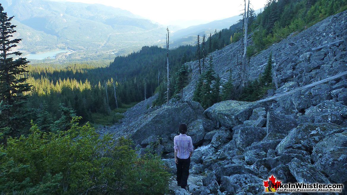
Brew Lake Trail Boulder Fields
Another remarkable highlight of the Brew Lake trail are the boulder fields along the continuously steep route. Over and over, you climb over and in between truck sized boulders absurdly crowded together from centuries of crumbling from the alarmingly steep cliffs above. Often, you stop and lean against a cliff to catch your breath only to notice that it is not a cliff, but instead a ridiculously enormous boulder that is perched on the edge of a cliff of other sized boulders, themselves perched on a cliff of boulders. None of which look capable of supporting what is above it. And all of which look likely to collapse in a cataclysmic instant that would forever leave you under a mile of mountain.
Daisy Lake in the Distance
Twisted, Gnarled Krummholz
Strangely the chaotic brutality of these sections of the Brew Lake trail are also some of the most dramatically beautiful. Seeing boulders, some the size of houses as far as you can see. Giant mangled trees crushed between them. Then in a few steps you are back in the forest, clinging to tree roots as you scramble up steep tunnels of forest squinting to see the next orange trail marker. Every so often you emerge from the jungle tunnels to a flat clearing, oddly dry and hardly any trees. What trees there are are ferociously hardy looking krummholz. Once again, you eventually work out the reason for such unusual little places in the otherwise lush forest. These places exist on relatively recently deposited, house sized boulders. Centuries have smoothed the surrounding areas over into lush forests, but some of these bulges are too high in the ground. The soil is thin and any trees that take root have to survive on what become like small desert islands. Dry and hot all summer and only the hardiest of trees survive. Twisted, gnarled krummholz occupy these eerie and numerous, dry plateaus.
Krummholz Along the Brew Lake Trail

Tricky Access to the Brew Lake Trailhead
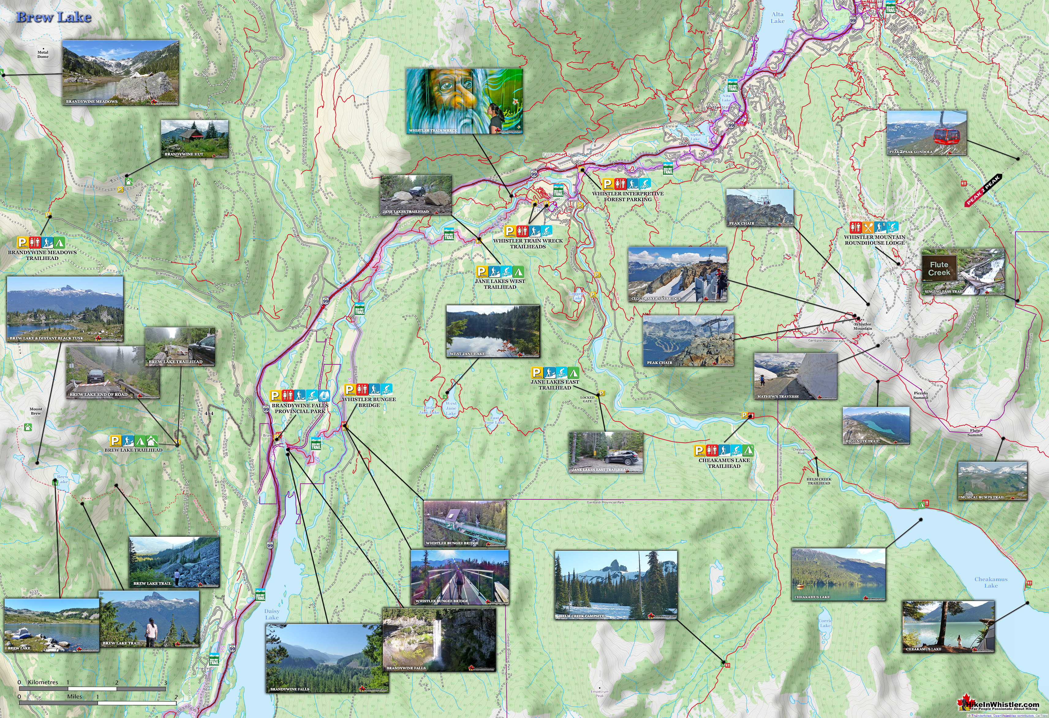
The Brew Lake trail, which has at least three access points, none with signs, however, the trail itself is well marked. So once you find the trail markers you will have found the Brew Lake trail. The various ways are not very straight forward and active logging in the area seems to effect the access points almost yearly. Brew Lake in the past was often reached by starting at Brandywine Falls Provincial Park and hiking along train tracks for a couple kilometres before reaching a barely marked Brew Lake trailhead at the edge of the train tracks. This access is long and tedious, parking is a big problem, and of course walking along the train tracks is illegal. There is a better and shorter access point further up the Brew Lake Trail, accessible from the Brew Main Road and seems to currently be the shortest summer hiking route. This is the best trailhead for the foreseeable future. This area is home to the Whistler RV Park and Campground, and despite the logging road leading to the unmarked trailhead to Brew Lake, it is not too difficult to find. From the Sea to Sky Highway (16.3 kilometres south of Whistler Village at Village Gate Boulevard), turn right when you see the sign for Whistler RV Park onto Brew Creek Road. In just 600 metres continue straight onto the gravel road (Brew Main FSR). See the maps below for detailed directions and parking and trailhead locations. This route is considerably shorter than the longer, train track trespassing route that has been used in the past.

Driving Directions to Brew Lake
![]() Cell coverage is reliable for most of the trail and the vicinity of Brew Lake and Mount Brew so you will likely be able to access the internet if you have a data plan, however saving this map image may be a good idea if you can't get a signal. There are two maps here as finding the unmarked trailhead is very difficult if you don't have a map handy. Once you find the trail however, you will be able to keep to it fairly easily. This is the directions shown on the first map below: Zero your odometer at Village Gate Blvd in Whistler Village and drive south on Hwy 99. At 16.3km turn right at the sign for Whistler RV Park(Brew Creek Road). At 16.9km continue straight onto the gravel road(Brew Main FSR). Directions continued below on the second map.
Cell coverage is reliable for most of the trail and the vicinity of Brew Lake and Mount Brew so you will likely be able to access the internet if you have a data plan, however saving this map image may be a good idea if you can't get a signal. There are two maps here as finding the unmarked trailhead is very difficult if you don't have a map handy. Once you find the trail however, you will be able to keep to it fairly easily. This is the directions shown on the first map below: Zero your odometer at Village Gate Blvd in Whistler Village and drive south on Hwy 99. At 16.3km turn right at the sign for Whistler RV Park(Brew Creek Road). At 16.9km continue straight onto the gravel road(Brew Main FSR). Directions continued below on the second map.

The Brew Main FSR Directions
![]() This map shows directions once you leave the paved road onto the gravel, Brew Main forest service road, which has deteriorated over the years and is now challenging to drive even with a 4x4. Some sections are quite steep and with plenty of loose boulders. Most of the road is quite narrow with the forest growing in from the sides. This logging road takes you 4.3 kilometres up into the forest and abruptly stops at a small, disintegrating bridge where you now need to park and begin hiking the road for 1km to connect to the Brew Lake trail. Several of the large planks on the bridge have fallen through and there is a plastic barrier blocking it. There is room for a couple cars to park alongside the road just a few metres from this bridge and room for several cars further back down the road. Best not to block the road by parking as you do find the occasional vehicle parked beyond this bridge by some brave drivers that manage to cross it successfully.
This map shows directions once you leave the paved road onto the gravel, Brew Main forest service road, which has deteriorated over the years and is now challenging to drive even with a 4x4. Some sections are quite steep and with plenty of loose boulders. Most of the road is quite narrow with the forest growing in from the sides. This logging road takes you 4.3 kilometres up into the forest and abruptly stops at a small, disintegrating bridge where you now need to park and begin hiking the road for 1km to connect to the Brew Lake trail. Several of the large planks on the bridge have fallen through and there is a plastic barrier blocking it. There is room for a couple cars to park alongside the road just a few metres from this bridge and room for several cars further back down the road. Best not to block the road by parking as you do find the occasional vehicle parked beyond this bridge by some brave drivers that manage to cross it successfully.

End of the Road 1km to the Brew Lake Trail

Finding the Brew Lake trail is tricky from this overgrown logging road as the flagging tapes only begin when you near the trail(about 30 metres from the overgrown logging road). This short, 30 metre long section that sort of links the old logging road to the Brew Lake trail is hard to spot. It is however, very accurately shown on the maps below. So just look for where it should be and walk into the trees until you spot the orange tree markers as well as the large yellow, square reflectors on the trees.

The trail is well marked with orange tape, yellow tree reflectors, older worn out silver tree reflectors and rock cairns almost every dozen metres. This is well needed though as the trail is at times extremely steep, for the most part overgrown and never in a straight line as it winds its way through wonderfully deep forest. You gain elevation very fast and there are dozens of fantastic viewpoints. Black Tusk and Mount Garibaldi are clearly visible across the valley as well as Wedge Mountain in the distance.
Sometimes Rocky and Steep Brew Lake Trail

Despite the frequency of trail markings, it is very easy to wander off of the trail, and this is a very dangerous trail to get lost on. Much of it traverses through mighty boulder fields with precarious truck sized rocks around and above you. Fortunately, if/when you stray off of the trail, backtracking a few metres gets you back on track easily and the trail markers are so consistent that if you don't see one for more than 30 metres or so, you are probably not on the trail. Keep this in mind on the boulder sections. You will always see rock cairns to guide you so if you don't see any indications of a trail, cairn, worn path or other markers, then don't continue for more than 30 metres. You definitely want to have a map of the trail in your pocket and/or a gps or phone with a gps and map of the area for peace of mind and safety. Having a flashlight/headlamp on this trail is essential for safety as well. When the sun gets low in the sky in the evening the trail markers get very hard to spot.
Alpine Paradise & People Free

If you do weather the difficult hike you will arrive at a beautiful, secluded backcountry paradise. Beautiful alpine hills and green meadows everywhere you look. There is even a hut available to use further up toward Mount Brew that is usable by anyone. It is easy to find. From the shore of Brew Lake look up and you will see a distinct trail disappearing into the distance across the lake. Follow this trail for about 45 minutes and you will arrive at the hut. By way of comparison to other hiking trails in the Whistler area, Brew Lake ranks as very difficult. Overall the elevation gain is considerable as you gain 745 metres in just 5 kilometres! Almost equal to the notoriously challenging Wedgemount Lake trail which gains 1220 metres in just 7 kilometres. Or the nearby Cirque Lake trail which gains 300 metres in just 2 kilometres The trail length is quite short compared to most other trails around Whistler. The Brew Lake trail is just 5 kilometres long, one way. Compare that to the Wedgemount Lake trail at 7 kilometres, the Garibaldi Lake trail at 9 kilometres, Black Tusk at 13.5 kilometres and Panorama Ridge at 15 kilometres.
Black Tusk in the Distance


Camping at Brew Lake
![]()
![]() There are lots of places to put up a tent along the erratic strewn shores of Brew Lake and further up the slope toward Mount Brew there are several amazing meadows, grass clearings and beautiful streams to camp near. Keep in mind that snow persists in this area well into the summer. Sometimes patches of snow will be seen well into August despite the daytime temperatures in the mid 20's (80-90 Fahrenheit)! As Brew Lake is not part of any park it doesn't have campsite facilities like you would find in Garibaldi Park, but you quickly see that this is a good thing. Not that Garibaldi Park campsite facilities are bad, but having a few untouched places within hiking distance are great to find and have a serenity about them that tent pads and signs take away from.
There are lots of places to put up a tent along the erratic strewn shores of Brew Lake and further up the slope toward Mount Brew there are several amazing meadows, grass clearings and beautiful streams to camp near. Keep in mind that snow persists in this area well into the summer. Sometimes patches of snow will be seen well into August despite the daytime temperatures in the mid 20's (80-90 Fahrenheit)! As Brew Lake is not part of any park it doesn't have campsite facilities like you would find in Garibaldi Park, but you quickly see that this is a good thing. Not that Garibaldi Park campsite facilities are bad, but having a few untouched places within hiking distance are great to find and have a serenity about them that tent pads and signs take away from.

There are no campsite facilities at Brew Lake, just a beautiful wilderness paradise. If you want civilized comfort, hike up towards Mount Brew and you will come to the Brew Hut. An elaborate two level hut that is well equipped and capable of accommodating over dozen people! Popular in the winter with skiers, the Brew Hut is rarely used in the summer. Maintained by the Varsity Outdoor Club of UBC, the hut is insulated, has a wood stove, gas stove, lantern and a nearby outhouse. With the scarcity of firewood though, don't expect to use the wood stove in the summer as this is a luxury reserved for the cold winters. In the summer months the Brew Hut is more of a curiosity to explore than an essential shelter as it is the rest of the year. If you do stay at the Brew Hut the VOC requests a $10 usage fee, per person, per night and there is a drop-box at the hut for that purpose.
Restrictions at Brew Lake
![]() Like much of BC, campfires are prohibited due to the extreme risk of forest fire. There are few restrictions at Brew Lake, due to it being located on Crown land. Unlike the majority of the amazing hiking trails in Whistler and Garibaldi Park, the Brew Lake trail is dog friendly. Your dog will go insane with excitement when he spots the bizarre little swimming mice that can be found on the far shore of the lake among the boulders. They run around in pairs, oddly not taking notice of humans. Chasing each other along the shores and in and under the water remarkably fast providing an unusual show.
Like much of BC, campfires are prohibited due to the extreme risk of forest fire. There are few restrictions at Brew Lake, due to it being located on Crown land. Unlike the majority of the amazing hiking trails in Whistler and Garibaldi Park, the Brew Lake trail is dog friendly. Your dog will go insane with excitement when he spots the bizarre little swimming mice that can be found on the far shore of the lake among the boulders. They run around in pairs, oddly not taking notice of humans. Chasing each other along the shores and in and under the water remarkably fast providing an unusual show.
Legendary Mountaineers & Explorers
 Neal Carter Mountaineer
Neal Carter (14 Dec 1902 – 15 Mar 1978) was a mountaineer and early explorer of the Coast Mountains primarily in the 1920’s and 1930’s. Highly skilled as a mountaineer and climber, Carter also excelled at cartography and surveying which he used to map the vast unnamed and unexplored mountains of BC. He named a staggering number of mountains and alpine features, as well as making at least 25 first ascents, many around what we now call the Whistler Valley. Carter began climbing the mountains around Vancouver as a teenager and at the age of seventeen he met someone who would change his life forever. In 1920, while hiking with high school friends Carter had a chance encounter with Tom Fyles, arguably the greatest mountaineer of the era. Continued here.
 Tom Fyles Mountaineer
Tom Fyles (27 June 1887 - 27 March 1979) was an astoundingly skilled climber that figured prominently in the mountaineering community in Vancouver for more than two decades. From his introduction to mountaineering in 1912, to his prolific array of elite level climbing ascents that began in earnest just four years later. In 1916 he solo climbed The Table in Garibaldi Park, a mountain widely considered to be too difficult and dangerous to even attempt. Those that knew him well admired his friendliness, enthusiasm, boundless endurance and incredible ability to read a mountain and navigate the best route to the summit. He made many first ascents and inspired countless new climbers, some becoming giants of the era. Continued here.
Whistler's Best Hiking Trails!
Whistler & Garibaldi Park Best Hiking by Month!


Explore BC Hiking Destinations!

Whistler Hiking Trails

Squamish Hiking Trails

Vancouver Hiking Trails

Clayoquot Hiking Trails
Victoria Hiking Trails

