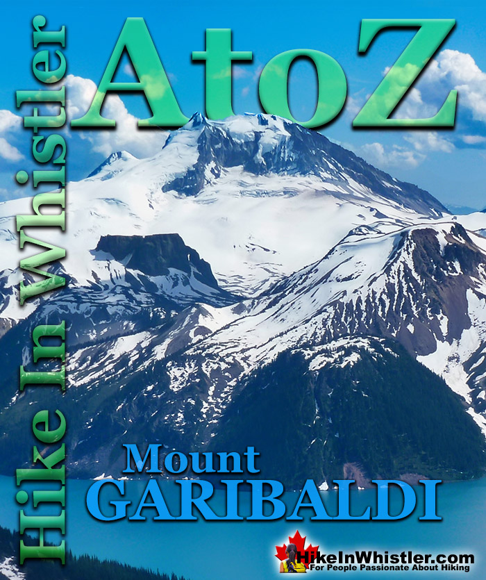
Mount Garibaldi is the huge, potentially active volcano that Garibaldi Provincial Park is named after. Mount Garibaldi also lends its name to the Garibaldi Ranges, the group of mountain ranges that fill Garibaldi Park. A subsection of the Garibaldi Ranges is the Garibaldi Névé, which is the large icefield that stretches out along the east side of Mount Garibaldi.
Whether you are standing in Squamish or high up on Panorama Ridge, Mount Garibaldi towers in the distance. From a wonderful vantage point such as Brandywine Meadows high up in the mountains across the valley, Mount Garibaldi appears monstrously huge. It is easy to imagine it bursting to life as an active volcano, which it technically still is. Named after a 19th century patriot and soldier, Giuseppe Garibaldi, Mount Garibaldi is a massive 2678 metre giant at the southern end of the park. It was named after Garibaldi by Captain George Henry Richards of the Royal Navy in 1860. Guiseppe Garibaldi had gained worldwide acclaim that year by unifying Italy by repatriating Sicily and Naples. In 1907 a group of Vancouver climbers reached the summit of Mount Garibaldi and marvelled at the view. In particular, Garibaldi Lake and Black Tusk caught their interest. Several forays into the area followed and a regular hiking camp was established between Black Tusk and Garibaldi Lake. In 1920 the Garibaldi Park Reserve was established and in 1927 Garibaldi Provincial Park was born.
Mount Garibaldi From Panorama Ridge
Mount Garibaldi, The Table and Mount Price
Garibaldi's Peaks
Garibaldi has two peaks in addition to the highest peak that is referred to as Mount Garibaldi , with an elevation of 2678 metres/8786 feet. The next highest peak is Atwell Peak on the southern edge of the summit plateau, with an elevation of 2655 feet/8711 feet. Atwell Peak is named after Atwell King, who led the first recorded ascent of Mount Garibaldi in 1907. One of the guides in the party, Arthur Tinniswood Dalton, has the third highest peak of Mount Garibaldi named after him. Dalton Dome is located on the west of the main summit and sits at an elevation 2653 metres/8704 feet and can be distinguished by its rounded shape. Other minor summits on Mount Garibaldi include, The Tent at 2465 metres/8087 feet, Diamond Head at 2056 metres/6745 feet, and so named because of its resemblance to Hawaii's Diamond Head.
Mount Garibaldi From Alice Lake
Mount Garibaldi From Black Tusk
Mount Garibaldi From Brandywine Meadows
More Whistler & Garibaldi Park Hiking A to Z!
Whistler can be expensive. Everything worth doing seems to cost a lot of money. But if you step back from the noise and crowds you may spot some secret ...
Along Whistler’s Valley Trail near Rainbow Park you come across some impressively unusual trees. Unlike most other Whistler trees with straight trunks and ...
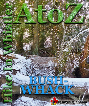
Bushwhack is a term often used in Canada and the United States to refer to hiking off-trail where no trail exists. Literally means 'bush' and 'whack'. To ...
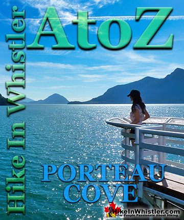
Porteau Cove is a beautiful little stop on the drive to or from Whistler. You will notice the lack of convenient washroom stops on the way to or from ...
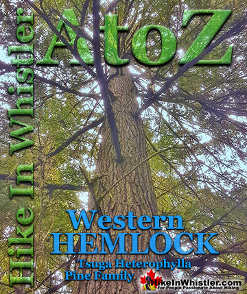
Western hemlock (tsuga heterophylla) is a large evergreen coniferous tree that is native to the west coast of North America. Unlike many other trees in ...
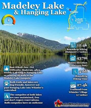
Madeley Lake is a gorgeous mountain lake located high up in the Callaghan Valley just a short drive past Alexander Falls. From Whistler Village it takes about 50 minutes to drive the 27.4 kilometres to get ...
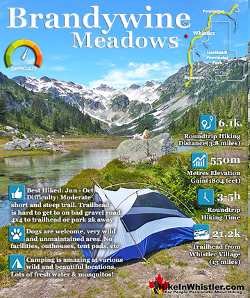
Brandywine Meadows is a nice, relatively short hike to a massive flower filled valley high up in Callaghan Valley. Located 40 minutes south of Whistler, this tough and sometimes muddy trail gains a huge 550 ...
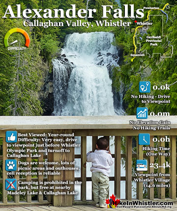
Alexander Falls is a very impressive 43 metre/141 foot waterfall just 30 to 40 minutes south of Whistler in the Callaghan Valley. Open year-round and located just before Whistler Olympic Park where several ...
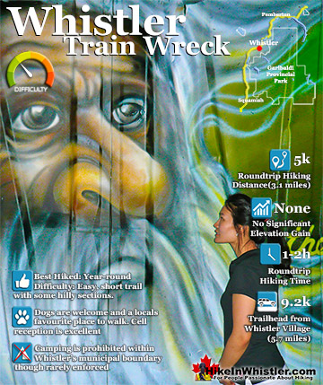
The trail to Whistler Train Wreck is an easy, yet varied route through deep forest, across a great suspension bridge over Cheakamus River, to a stunning array of wrecked train cars. The trail from your car to ...
Hiking in Whistler in October is often unexpectedly stunning. The days are much shorter and colder but the mountains are alive with colour from the fall ...
November in Whistler is when the temperatures plummet and the first heavy snow falls in the alpine and often in Whistler Village. The hiking opportunities become ...
December hiking in Whistler is mainly done on snowshoes, though not always. If it hasn't snowed much recently then trails such as Whistler Train Wreck and ...
Hiking in Whistler is spectacular and wonderfully varied. Looking at a map of Whistler you see an extraordinary spider web of hiking trails that are unbelievably numerous. Easy trails, moderate trails and challenging hiking trails are all available. Another marvellous ...
Squamish is located in the midst of a staggering array of amazing hiking trails. Garibaldi Provincial Park sprawls alongside Squamish and up and beyond Whistler. Tantalus Provincial Park lays across the valley to the west and the wonderfully remote Callaghan Valley ...
Clayoquot Sound has a staggering array of hiking trails within it. Between Tofino and Ucluelet, Pacific Rim Park has several wilderness and beach trails, each one radically different from the last. The islands in the area are often Provincial parks on their own with ...
Victoria has a seemingly endless number of amazing hiking trails. Most take you to wild and beautiful Pacific Ocean views and others take you to tranquil lakes in beautiful BC Coastal Rainforest wilderness. Regional Parks and Provincial Parks are everywhere you turn in ...
The West Coast Trail was created after decades of brutal and costly shipwrecks occurred along the West Coast of Vancouver Island. One shipwreck in particular was so horrific, tragic and unbelievable that it forced the creation of a trail along the coast, which ...