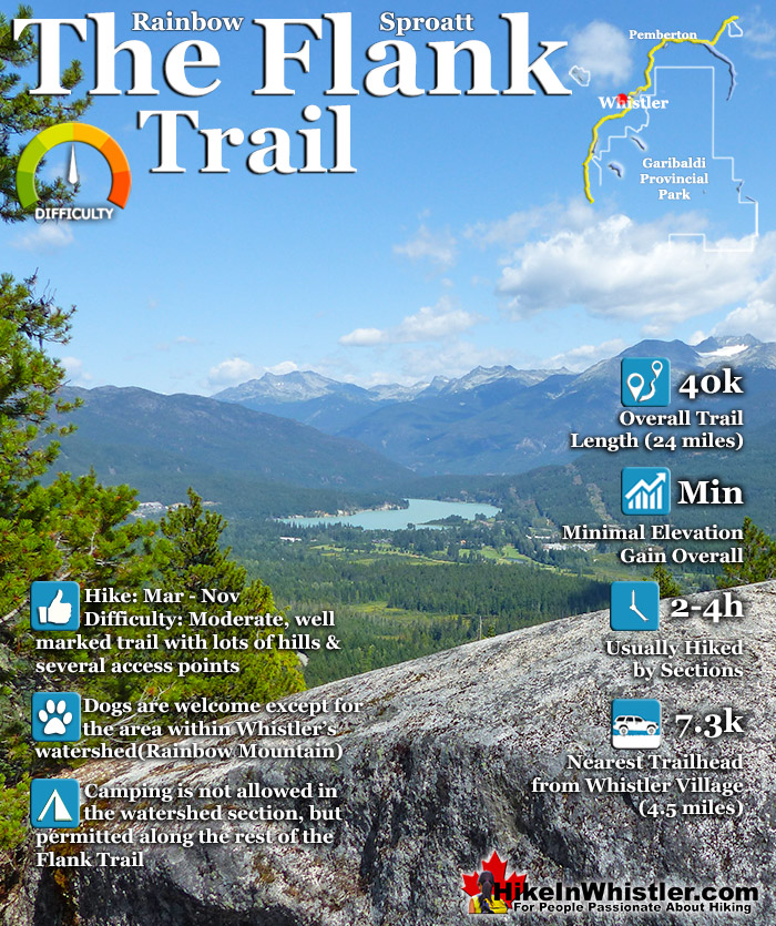
![]() Hiking and biking trails are so abundant in Whistler that many go unnoticed, neglected or taken for granted. The Flank Trail is one of these. Most people in Whistler don't even know about it, but the ones that do, love it. Officially known as the Rainbow-Sproatt Flank Trail, it runs the length of Whistler Valley, opposite Whistler Mountain and Blackcomb Mountain, and connects Rainbow Mountain and Mount Sproatt with dozens of hiking and biking trails.
Hiking and biking trails are so abundant in Whistler that many go unnoticed, neglected or taken for granted. The Flank Trail is one of these. Most people in Whistler don't even know about it, but the ones that do, love it. Officially known as the Rainbow-Sproatt Flank Trail, it runs the length of Whistler Valley, opposite Whistler Mountain and Blackcomb Mountain, and connects Rainbow Mountain and Mount Sproatt with dozens of hiking and biking trails.
 Relatively quiet compared to other trails
- Spans the entire Whistler Valley!
- Hard to beat views of Whistler far below
- Many access trailheads along its length
- Many branching trails extend to the alpine
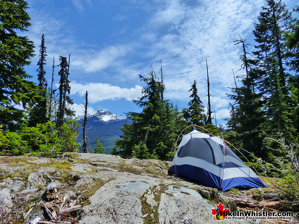
- Bivouacking along the trail is amazing
- Mostly dog friendly & off the radar
 Nice trail, but not overly exciting
- No spectacular destination to reach
- Alternate routes are more scenic
Whistler & Garibaldi Hiking
![]() Alexander Falls
Alexander Falls ![]() Ancient Cedars
Ancient Cedars ![]() Black Tusk
Black Tusk ![]() Blackcomb Mountain
Blackcomb Mountain ![]() Brandywine Falls
Brandywine Falls ![]() Brandywine Meadows
Brandywine Meadows ![]() Brew Lake
Brew Lake ![]() Callaghan Lake
Callaghan Lake ![]() Cheakamus Lake
Cheakamus Lake ![]() Cheakamus River
Cheakamus River ![]() Cirque Lake
Cirque Lake ![]() Flank Trail
Flank Trail ![]() Garibaldi Lake
Garibaldi Lake ![]() Garibaldi Park
Garibaldi Park ![]() Helm Creek
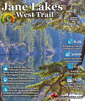
Helm Creek ![]() Jane Lakes
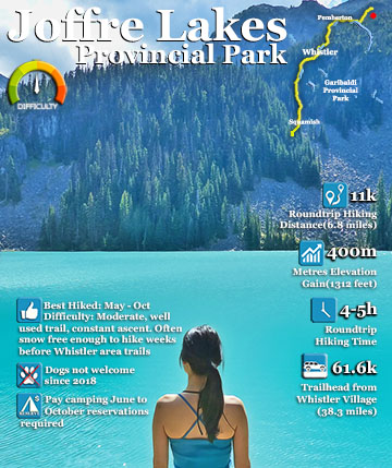
Jane Lakes ![]() Joffre Lakes
Joffre Lakes ![]() Keyhole Hot Springs
Keyhole Hot Springs ![]() Logger’s Lake
Logger’s Lake ![]() Madeley Lake
Madeley Lake ![]() Meager Hot Springs
Meager Hot Springs ![]() Nairn Falls
Nairn Falls ![]() Newt Lake
Newt Lake ![]() Panorama Ridge
Panorama Ridge ![]() Parkhurst Ghost Town
Parkhurst Ghost Town ![]() Rainbow Falls
Rainbow Falls ![]() Rainbow Lake
Rainbow Lake ![]() Ring Lake
Ring Lake ![]() Russet Lake
Russet Lake ![]() Sea to Sky Trail
Sea to Sky Trail ![]() Skookumchuck Hot Springs
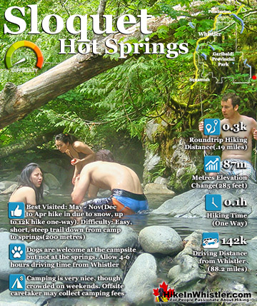
Skookumchuck Hot Springs ![]() Sloquet Hot Springs
Sloquet Hot Springs ![]() Sproatt East
Sproatt East ![]() Sproatt West
Sproatt West ![]() Taylor Meadows
Taylor Meadows ![]() Train Wreck
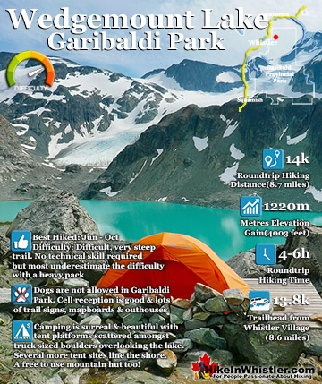
Train Wreck ![]() Wedgemount Lake
Wedgemount Lake ![]() Whistler Mountain
Whistler Mountain
![]() January
January ![]() February
February ![]() March
March ![]() April
April ![]() May
May ![]() June
June ![]() July
July ![]() August
August ![]() September
September ![]() October
October ![]() November
November ![]() December
December
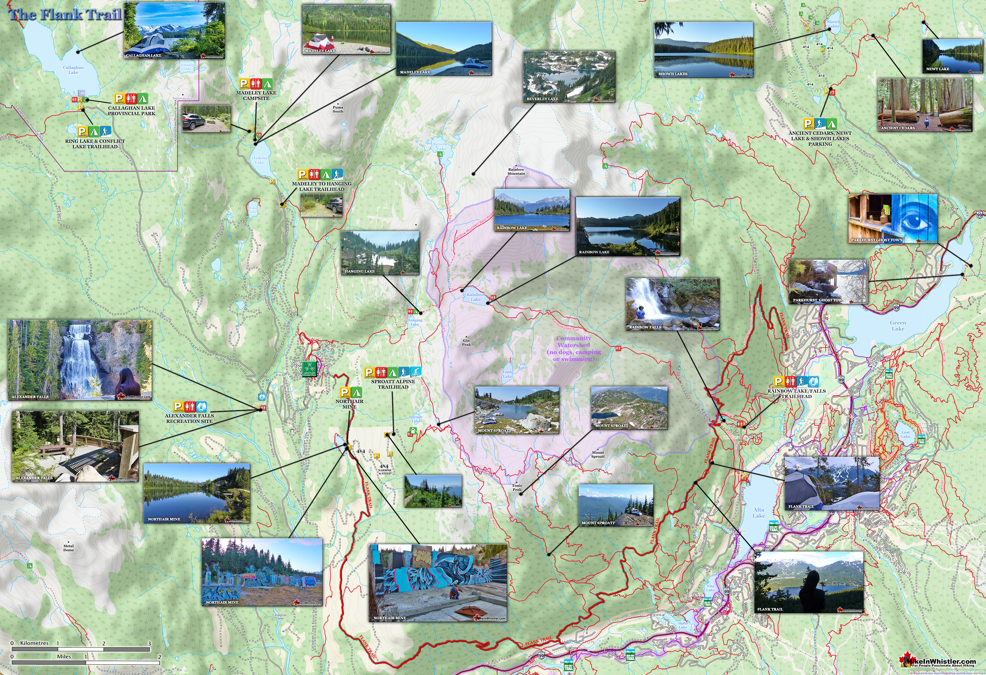
Mount Sproatt and Rainbow Mountain dominate the view across the valley from Whistler Village and the Rainbow-Sproatt Flank Trail traces a 40 kilometre route along the flank of these two mountains. One end is high up in the Callaghan Valley near Whistler Olympic Park and the other is near Ancient Cedars & Showh Lakes! At various places along the trail there are access points. The Rainbow Trail trailhead is a popular access point for the Flank Trail as it enters the trail at roughly its midpoint. Another good access is in Function Junction that can be found behind 1200 Alpha Lake Road at the old trailhead to Whistler Train Wreck. Over the years the Rainbow-Sproatt Flank Trail has been trimmed a bit. With the building of Whistler Olympic Park for the 2010 Olympics the trailhead was pushed across the valley toward Northair Mine. Much of this section of trail was, and still is old logging roads, so it doesn’t look or feel like a trail until it bends toward Whistler a few kilometres south of Northair Mine. Previous to the Olympics the Callaghan Valley trailhead was just a stones throw north of Alexander Falls at the bridge that takes you to Callaghan Lake and Madeley Lake. Now the trailhead is not marked at that end and is assumed to be north of Northair Mine at the edge of Whistler Olympic Park or at Northair Mine itself.


Highlights of the Flank Trail
![]() The 40 kilometre trail takes you past some pretty amazing sights. From the beginning, Whistler Olympic Park is interesting to see. Sitting high up in the Callaghan Valley and built for the 2010 Olympic Games, Whistler Olympic Park is an impressive, civilized oasis in an otherwise thick forest wilderness. Open seasonally, this metropolis in the woods, depending on the season is home to cross country skiing, snowshoeing, a biathlon experience, a surprisingly nice cafe, and endless trails to see the Olympic sights. Not least the giant ski jump that you can get up close to appreciate its enormity. There is an entry charge to get past the gate and unfortunately, more often than not, you will find Whistler Olympic Park closed. The westernmost access to the Flank Trail, if you don't count the usually inaccessible Olympic Park, is effectively the long abandoned Northair Mine. This briefly thriving gold mine is now an unusual little world in the woods. A beautiful little man-made lake dominates the area now with a dirt road running along its edge, and to the surreal, cement skeleton-like foundations of what must have been quite a large building. The foundations are now adorned with brightly painted murals and several small fire pits. Standing in the relic you can look across the beautiful lake, green forest beyond and Rainbow Mountain in the distance. In the summer and fall you can drive to Northair Mine as the Flank Trail that passes here is more accurately an old logging road, than a hiking trail.
The 40 kilometre trail takes you past some pretty amazing sights. From the beginning, Whistler Olympic Park is interesting to see. Sitting high up in the Callaghan Valley and built for the 2010 Olympic Games, Whistler Olympic Park is an impressive, civilized oasis in an otherwise thick forest wilderness. Open seasonally, this metropolis in the woods, depending on the season is home to cross country skiing, snowshoeing, a biathlon experience, a surprisingly nice cafe, and endless trails to see the Olympic sights. Not least the giant ski jump that you can get up close to appreciate its enormity. There is an entry charge to get past the gate and unfortunately, more often than not, you will find Whistler Olympic Park closed. The westernmost access to the Flank Trail, if you don't count the usually inaccessible Olympic Park, is effectively the long abandoned Northair Mine. This briefly thriving gold mine is now an unusual little world in the woods. A beautiful little man-made lake dominates the area now with a dirt road running along its edge, and to the surreal, cement skeleton-like foundations of what must have been quite a large building. The foundations are now adorned with brightly painted murals and several small fire pits. Standing in the relic you can look across the beautiful lake, green forest beyond and Rainbow Mountain in the distance. In the summer and fall you can drive to Northair Mine as the Flank Trail that passes here is more accurately an old logging road, than a hiking trail.

Flank Trail Views
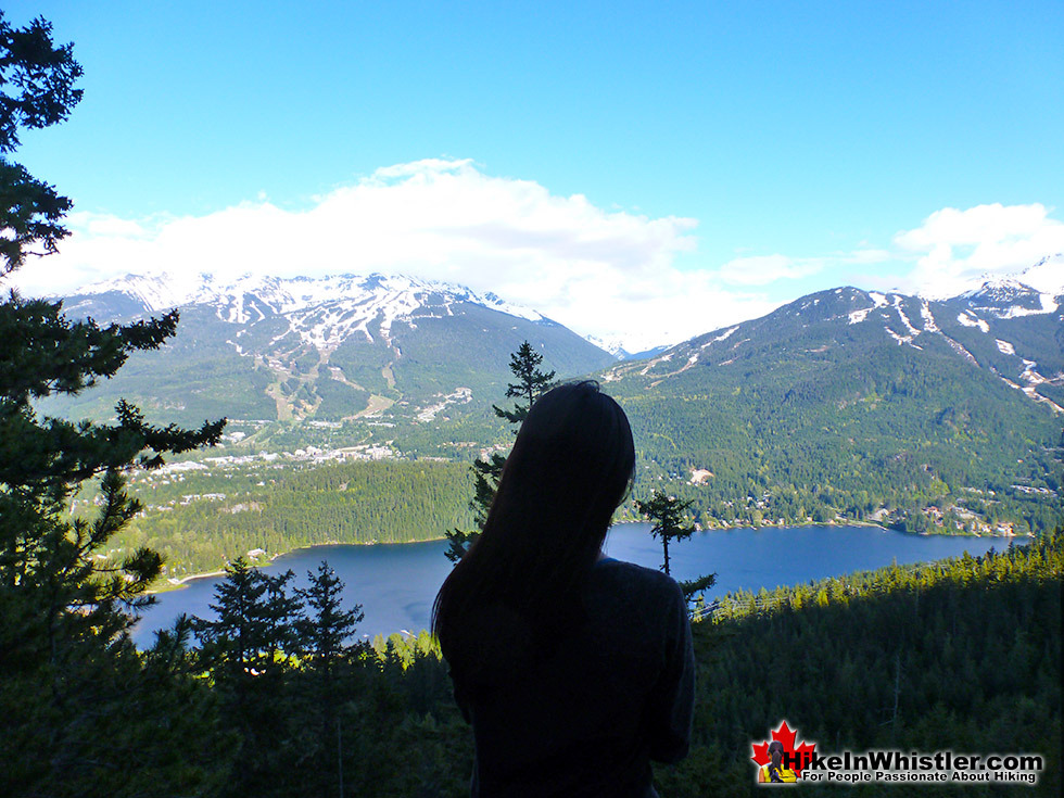
Past Northair Mine, the Flank Trail slowly descends toward Whistler and the logging road finally gives way to a wide trail that you quickly discover is popular with bikes. The length, width and beautifully gradual elevation gain and loss of the Flank Trail makes it an amazing trail on a bike. You can cover a great distance, see dozens of amazing viewpoints and all the while along are comparatively relaxing route. The Flank Trail continues to descend all the way to Function Junction, the southernmost neighbourhood in Whistler. It then turns 90 degrees to the left and ascends quickly along the flank of Mount Sproatt. Tremendous glimpses of Alpha Lake, then Nita Lake, and finally Alta Lake come into view as you appreciate how quickly you have climbed. Paddle-boarders on the lakes are tiny specks that take a moment for your mind to comprehend what they are. Along this section, more than any other on the Flank Trail, you see frequent side trails. Almost always on your right, but more recently on the left. These purpose built bike trails, almost all black diamond in difficulty, plunge into the forest and along and over rock cliffs, over bridges and shockingly steep ramps. The Flank Trail inspired the creation of bike trails, which in turn enable more hiking trails. This back and forth trail building frenzy has, and is, producing a bewildering and ever expanding trail network on this once sleepy side of the valley.


Flank Trail and the Rainbow Trail
At roughly the mid point of the Flank Trail you will come to a small, overlapping section of the Rainbow Trail, near Rainbow Falls. From Whistler Olympic Park to the Rainbow Trail, you will have hiked halfway around Mount Sproatt. The Flank Trail seems to terminate at the Rainbow Trail, however a small sign directs you to turn right, follow the Rainbow Trail, for a couple hundred metres, then left after the water treatment building to the beautiful bridge over Twentyone Mile Creek. A beautiful way to access the Flank Trail on snowshoes or on foot any time of the year is via the Rainbow Trail near Rainbow Park on the far side of Alta Lake. From the road-side parking at the trailhead you are immediately plunged into deep forest, deep snow, and the sound of crashing water nearby. The Rainbow Trail winds through the forest fairly steeply upward. In less than a kilometre you come to Rainbow Falls crashing down through huge pillows of snow. This little waterfall sits in a beautiful little snowy enclave that feels as though it belongs in some movie. Deep snow, crystal clear green water cascading down from a frozen cliff. A little, hidden paradise. One of many in Whistler. Further up the trail takes you to the first signs for the Flank Trail. The Flank Trail overlaps and crosses the Rainbow Trail for half a kilometre.


Flank Trail Twentyone Mile Creek Bridge
Following the Flank Trail to the right takes you to a very scenic bridge over Twentyone Mile Creek. Following the Flank Trail to the left leads you to a steady ascent for 400 metres along the Rainbow Lake trail to the trail turnoff to the Flank Trail. The Flank Trail from here quickly ascends through more deep forest and finally after 15 minutes opens up and flattens out. The views become beautiful and trail less tiring. Whistler, Blackcomb and Wedge mountains all come dramatically into view and Alta Lake appears far below. Just steps from the trail take you to pristine, snowy outcrops, perfect for taking in the view on a sunny day.. and with most of the Flank Trail south facing, sun will always be facing you over Whistler. The Flank Trail is way more than a day hike on foot or snowshoes. It is best tackled in pieces. The great advantage of accessing it from the Rainbow Trail is that you are roughly in the middle of the trail. On snowshoes, it is especially good. The Rainbow Trail is steep here, but very scenic and even small kids won't complain. Every bend in the trail reveals another great view. Dramatic views of the crashing creek, beautiful snow weighed down trees, wilderness waterfall and a wonderful, snowy bridge crossing, all in the first 15 minutes on the trail. Fantastic.


Guides to the Best of Whistler
 Best Dog Friendly Hiking Trails
Whistler is very dog friendly and the number of wonderful hiking trails that your dog will love is huge. The massively varied hiking trails range from easy, short, close to Whistler Village to challenging, long and deep in the endless wilderness around Whistler. You can find dog friendly trails in and around Whistler Village that take you through deep, dark and magical forests. Or you can drive beyond Whistler Village and take your dog to spectacular alpine lakes. Some requiring little or no hiking, while others are found after hiking challenging and long trails. Many of these places are comparatively quiet and often you and your dog will have the the wilderness to yourselves. In and around Whistler Village you have Lost Lake with its spider web of trails... Continued here.
 Best Free Whistler Camping
Whistler is surrounded by an immense wilderness dotted with spectacular, hidden lakes and amazing places to set up a tent. Decades of logging activity has left a network of forest service roads that has opened easy access to these places. Some of these you can drive to and some you may need a 4x4 to comfortably get to. Some places to camp for free you can drive to, some require a short hike and others are fairly long hikes to reach. Beautiful Callaghan Valley is home to several incredible and free places to camp. Callaghan Lake has a great free drive-to campsite just steps from this spectacular alpine lake. If you have a canoe, you can paddle to the end of Callaghan Lake and hike the short, but steep trail up to Cirque Lake. This gorgeous lake is deep in the alpine wilderness... Continued here.
 No Car? No Problem! Whistler Trails
Whistler as a resort has a wonderful car-free core. The Village Stroll runs through the heart of Whistler Village and is entirely car free. If you are visiting Whistler or living here and you don't have a car, it's no problem. On foot or on a bike you can travel the extensive network of non-motorized trails. The Valley Trail snakes through Whistler Village and extends in several directions, all of which lead to beautiful parts of Whistler. The Sea to Sky Trail and the Lost Lake trails continue this massive, car-free network of trails running almost everywhere in Whistler. When it comes to many of the best hiking trails, getting to the trailheads on foot, by bike or public transit can be tricky at best or complicated and impractical at worst. Many trailheads are far from Whistler Village and... Continued here.
 Kid Friendly Whistler Hiking Trails
There are plenty of excellent, kid and family friendly hiking trails and destinations in and around Whistler. Kid and family friendly generally means an easy and somewhat short trail that a toddler can happily manage. Some of these trails are flat enough to be stroller friendly, such as Brandywine Falls, Whistler Mountain and Blackcomb Mountain. Others such as Logger’s Lake, Cheakamus River and Madeley Lake have short enough trails to reach them that you can manage with little kids that don't want to hike too far. Some of these hikes and walks are popular and close to Whistler Village, like Whistler Mountain, Blackcomb Mountain, Lost Lake Park, Rainbow Park and Meadow Park. Others are a beautiful, but far drive into the mountains and tricky to find... Continued here.
 Best Sights Sea to Sky 99
The Sea to Sky Highway links Vancouver to Whistler and has several stops along the way that are often overlooked. Porteau Cove, for example, is surprisingly unknown even to locals that have driven past hundreds of times. Just off the highway the parking area is just steps from the huge pier stretching way out over the ocean. This gigantic pier is actually a rarely used emergency dock for BC Ferries, though more often used by visitors for its stunning views of Howe Sound. Porteau Cove is an excellent pit stop on the way to Whistler, not only for the spectacular views of Howe Sound, but one of the nicest picnic spots and most convenient restrooms! Other attractions along the Sea to Sky Highway are more obvious, such as Shannon Falls, the Sea to Sky Gondola... Continued here.
 Whistler Train Wreck Murals
The colourful graffiti and murals that make Whistler Train Wreck the magical place it is today began appearing in 2011, when this hidden place was known by just a few Whistler locals. In the summer of 2011 several Whistler artists came here for "The Train Wreck Paint Jam" and transformed the mangled wreckage into a surreal art exhibit. The artists ranged from aspiring graffiti artists to professional artists like Kups. Remnants of one of his murals from 2011 is found inside the first boxcar you come to after crossing the bridge into Whistler Train Wreck. Several of the original murals were gorgeous. Brilliantly coloured and surreal in such an unusual, tranquil and hidden forest with seven mangled train boxcars scattered. Like some sort of haunting art gallery... Continued here.
 Northair Mine Murals
Way up in the Callaghan Valley on the back side of Mount Sproatt is an abandoned gold mine. Old cement foundations and two unexpectedly beautiful lakes mark the location of Northair Mine, abandoned in 1982. It was a fairly productive gold mine that extracted five tons of gold. Largely forgotten for years, in the last decade it has come to life in stunning colour by graffiti artists and professional muralists. In the summer of 2013, the first mural appeared on the blank foundation walls of Northair Mine. A creation of a professional Whistler artist PETKO. Painted on one of the inside, pillar walls, the mural is about 8 feet tall and five feet wide of what looks like a robot snake in front of a cube background. It stood out in striking contrast to the grey walls in the background... Continued here.
Whistler's Best Hiking Trails!
Whistler & Garibaldi Park Best Hiking by Month!


Explore BC Hiking Destinations!

Whistler Hiking Trails

Squamish Hiking Trails

Vancouver Hiking Trails

Clayoquot Hiking Trails
Victoria Hiking Trails

