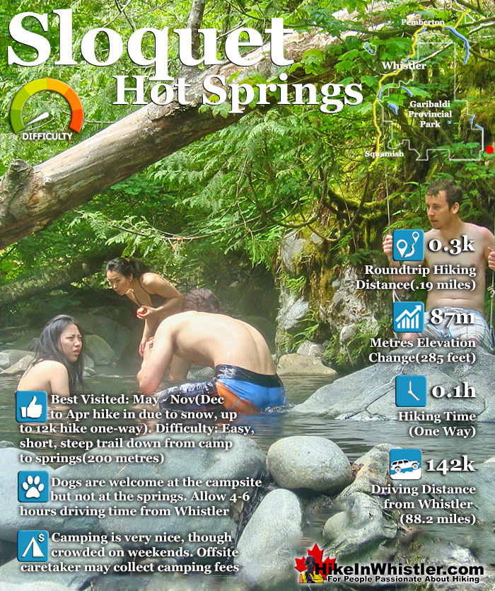
![]() Sloquet Hot Springs is a wonderfully wild set of shallow, man-made pools fed by a small, all natural, and very hot, waterfall. The pools stretch from the waterfall to the large and crashing Sloquet River. The large, spread out campsite for the hot springs lies a short 5 minute walk from the springs. You have to follow a dark and quickly descending trail toward the crashing river.
Sloquet Hot Springs is a wonderfully wild set of shallow, man-made pools fed by a small, all natural, and very hot, waterfall. The pools stretch from the waterfall to the large and crashing Sloquet River. The large, spread out campsite for the hot springs lies a short 5 minute walk from the springs. You have to follow a dark and quickly descending trail toward the crashing river.
 Incredible setting for relaxing in deep wilderness
- Fed by a waterfall & located next to a rushing river
- Drive in campsites are nicely spaced in the forest
- Springs & campsite are separated by a short trail
- Skookumchuck is on the way to Sloquet
- Several pools & two are quite large
- Far from civilization so often quiet
- Well laid out drive-to campsites
- Hike there in winter & you will have it to yourself!
 Campsite can get rowdy with tailgate parties
Whistler & Garibaldi Hiking
![]() Alexander Falls
Alexander Falls ![]() Ancient Cedars
Ancient Cedars ![]() Black Tusk
Black Tusk ![]() Blackcomb Mountain
Blackcomb Mountain ![]() Brandywine Falls
Brandywine Falls ![]() Brandywine Meadows
Brandywine Meadows ![]() Brew Lake
Brew Lake ![]() Callaghan Lake
Callaghan Lake ![]() Cheakamus Lake
Cheakamus Lake ![]() Cheakamus River
Cheakamus River ![]() Cirque Lake
Cirque Lake ![]() Flank Trail
Flank Trail ![]() Garibaldi Lake
Garibaldi Lake ![]() Garibaldi Park
Garibaldi Park ![]() Helm Creek
Helm Creek ![]() Jane Lakes
Jane Lakes ![]() Joffre Lakes
Joffre Lakes ![]() Keyhole Hot Springs
Keyhole Hot Springs ![]() Logger’s Lake
Logger’s Lake ![]() Madeley Lake
Madeley Lake ![]() Meager Hot Springs
Meager Hot Springs ![]() Nairn Falls
Nairn Falls ![]() Newt Lake
Newt Lake ![]() Panorama Ridge
Panorama Ridge ![]() Parkhurst Ghost Town
Parkhurst Ghost Town ![]() Rainbow Falls
Rainbow Falls ![]() Rainbow Lake
Rainbow Lake ![]() Ring Lake
Ring Lake ![]() Russet Lake
Russet Lake ![]() Sea to Sky Trail
Sea to Sky Trail ![]() Skookumchuck Hot Springs
Skookumchuck Hot Springs ![]() Sloquet Hot Springs
Sloquet Hot Springs ![]() Sproatt East
Sproatt East ![]() Sproatt West
Sproatt West ![]() Taylor Meadows
Taylor Meadows ![]() Train Wreck
Train Wreck ![]() Wedgemount Lake
Wedgemount Lake ![]() Whistler Mountain
Whistler Mountain
![]() January
January ![]() February
February ![]() March
March ![]() April
April ![]() May
May ![]() June
June ![]() July
July ![]() August
August ![]() September
September ![]() October
October ![]() November
November ![]() December
December
As you near, you can smell the unusual, but kind of nice hot springs scent, and you see steam rising all around you, some steam rising, bizarrely, out of the grass clearing on the edge of the river. On your left a rising cliff, on your right the crashing river. The path narrows and steepens, leading to a large fallen tree which the trail seems to run to. So huge though as to not worry you walking the length of. Then, there it is. The massive fallen tree flanks it. Nestled between the tree and a cliff, in a large triangular area, with the river forming the third side are the Sloquet Hot Springs. Sloquet Hot Springs is 142 kilometres from Whistler, which translates to well over 3 hours of driving. Much of the driving is along the In-Shuck-Ch Forest Service Road, which runs the length of the very scenic Lillooet Lake and river. This gravel road takes you well into the wilderness, far from civilization and past quite a few nice sights along the way. Just 20 minutes north of Whistler you pass Nairn Falls Provincial Park. This is a great pit-stop on the journey to Sloquet, whether you hike the short, 1.2 kilometre trail to the falls or just check out the river viewpoint near the parking lot. Back on the highway, Pemberton is just 5 minutes north of Nairn Falls. This little town is your last chance for gas, food, alcohol, ect before Sloquet. Continuing through Pemberton, on the way to Sloquet you will pass North Arm Farm. This is a great place to visit. You can wander around the beautiful farm grounds, visit the interesting farm animals and marvel at the amazing view of Mount Currie. The farm is free to visit and open weekends in the winter and everyday the rest of the year. They have a fantastic cafe with all sorts of baked goods and lunch items as well as various farm fresh produce for sale as well. Also, a great place for your last coffee before entering the wilderness.
Guides to the Best of Whistler
 Best Dog Friendly Hiking Trails
Whistler is very dog friendly and the number of wonderful hiking trails that your dog will love is huge. The massively varied hiking trails range from easy, short, close to Whistler Village to challenging, long and deep in the endless wilderness around Whistler. You can find dog friendly trails in and around Whistler Village that take you through deep, dark and magical forests. Or you can drive beyond Whistler Village and take your dog to spectacular alpine lakes. Some requiring little or no hiking, while others are found after hiking challenging and long trails. Many of these places are comparatively quiet and often you and your dog will have the the wilderness to yourselves. In and around Whistler Village you have Lost Lake with its spider web of trails... Continued here.
 Best Free Whistler Camping
Whistler is surrounded by an immense wilderness dotted with spectacular, hidden lakes and amazing places to set up a tent. Decades of logging activity has left a network of forest service roads that has opened easy access to these places. Some of these you can drive to and some you may need a 4x4 to comfortably get to. Some places to camp for free you can drive to, some require a short hike and others are fairly long hikes to reach. Beautiful Callaghan Valley is home to several incredible and free places to camp. Callaghan Lake has a great free drive-to campsite just steps from this spectacular alpine lake. If you have a canoe, you can paddle to the end of Callaghan Lake and hike the short, but steep trail up to Cirque Lake. This gorgeous lake is deep in the alpine wilderness... Continued here.
 No Car? No Problem! Whistler Trails
Whistler as a resort has a wonderful car-free core. The Village Stroll runs through the heart of Whistler Village and is entirely car free. If you are visiting Whistler or living here and you don't have a car, it's no problem. On foot or on a bike you can travel the extensive network of non-motorized trails. The Valley Trail snakes through Whistler Village and extends in several directions, all of which lead to beautiful parts of Whistler. The Sea to Sky Trail and the Lost Lake trails continue this massive, car-free network of trails running almost everywhere in Whistler. When it comes to many of the best hiking trails, getting to the trailheads on foot, by bike or public transit can be tricky at best or complicated and impractical at worst. Many trailheads are far from Whistler Village and... Continued here.

Driving to Sloquet Hot Springs
Another 10 minutes on the highway further and you come to the turnoff to the In-Shuck-Ch Forest Service Road and begin the long and beautiful drive along Lillooet Lake. There are several excellent places to stop along the way. From the obvious and frequent viewpoints along the road to the numerous campsites along the way. Even if you have no intention of camping, these are great places to stop and see Lillooet Lake, have a beer, swim, or all three. Depending on the season, Lillooet Lake can be emerald, though cloudy green or muddy brown. This is all dependent on the spring runoff and especially the silty brown, Lillooet River that flows into Lillooet Lake from Pemberton.


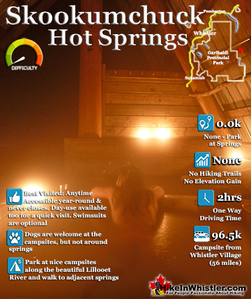
Skookumchuck Hot Springs on the Way to Sloquet
At 96 kilometres from Whistler Village you will come to Skookumchuck Hot Springs. This is a popular and beautiful campsite along the edge of Lillooet River and home to an odd collection of hot spring fed tubs. Though Skookumchuck is a bit messy looking, you would be crazy to not stop for an hour or two and give the tubs a try. It is a strange feature of Skookumchuck, that after you give the place a chance, you fall in love with the place. Despite the usually bad first impression most get, after 5 minutes in one of the tubs, the place becomes warm and welcoming. There is a drop in charge of $7.50 to use the springs and you will find a cash and envelope drop box on the way in by the caretaker house, or you may see the friendly caretaker and can pay him. If you can, get him talking. He's very funny and full of great stories about just about every subject you can imagine.

The Road to Sloquet Hot Springs
The final few kilometres to Sloquet is not terribly scenic except for the beautiful river crossing which will probably be your last stop before Sloquet. This very high, one lane, old-school logging bridge towers over, and is an amazing viewpoint over the Lillooet River. The sides of the bridge have a wooden, bench-like railing that all but invites you to sit, swing your legs over and watch the mighty, green whirling water below you. From here, Sloquet is just 20 minutes away, and the potholes quickly become gigantic. The beauty and wildness of Sloquet brings quite a few people to the area during some weekends and in the summer months. There is quite a lot of industrial activity in the area as well that brings in the occasional large groups of boisterous workers to the area.


Sloquet Hot Springs Campsite
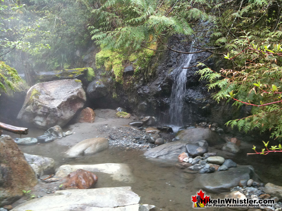
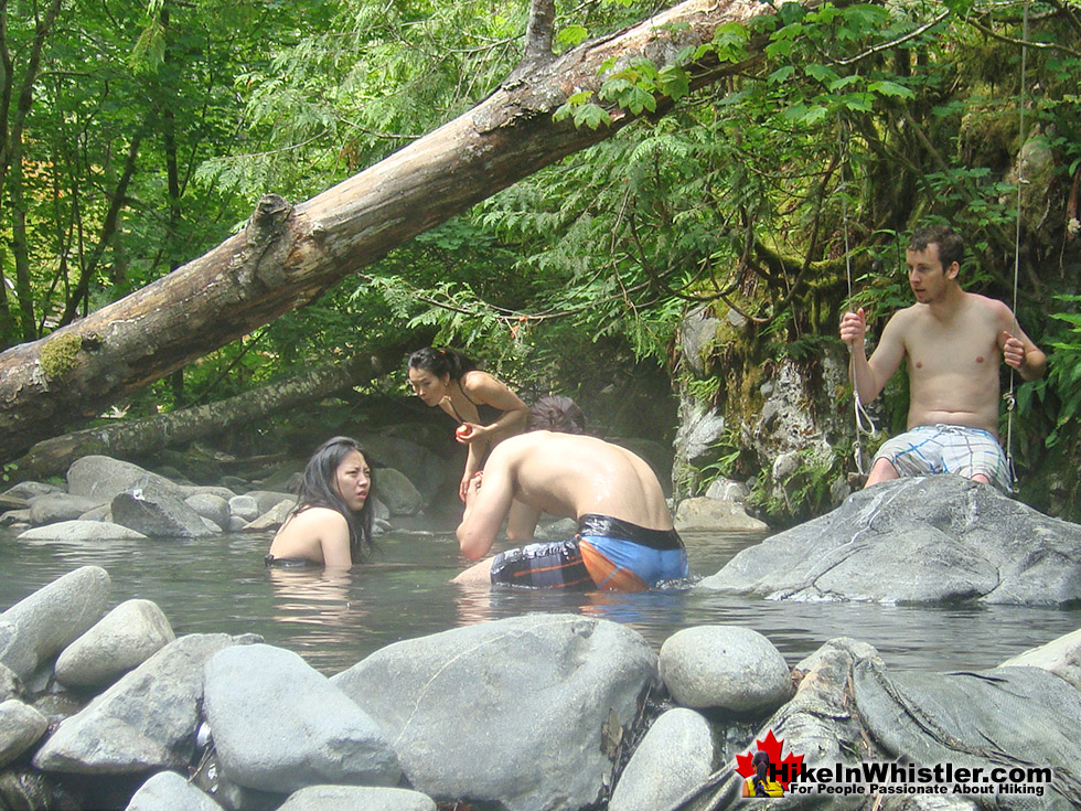
Though you will often find the campsite a loud and chaotic place with music playing and two or three campsite parties, the hot springs, a couple hundred metres away, serene and tranquil. This is one of the accidental beauties of Sloquet. The campsite and the hot springs are separated by this steep, short trail and deep forest keeps them apart from each other. The tailgate parties that sometimes erupt at the campsite are far removed from the hot springs oasis wedged between the river, cliff and forest. Sloquet is quite a contrast to its closest, well known neighbour, Skookumchuck Hot Springs. Skookumchuck is shabby, institutionalized and far from natural. Sloquet is beautiful, natural and serene. It consists of seven pools formed with rocks positioned to segment pools out of what must have been one huge pool. Recently, in late 2013, dozens of volunteers did a massive cleanup of the pools, forming them into a more natural and even more beautiful place to be.

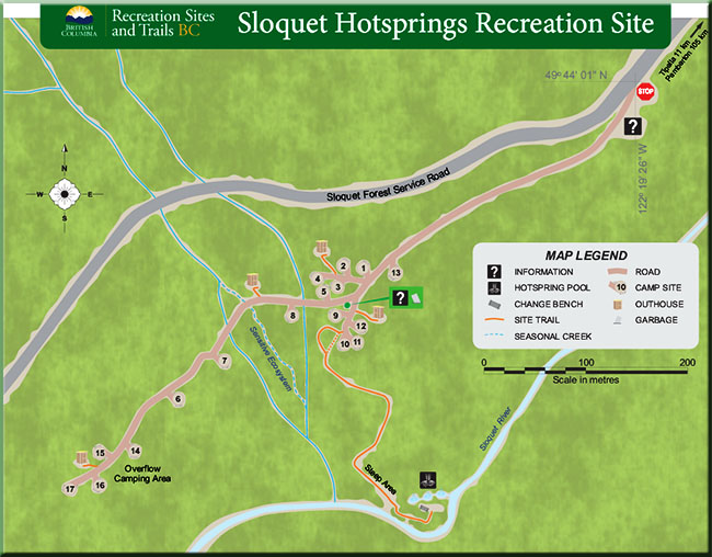 It is the natural, cozy and hidden feeling you get at the Sloquet Hot Springs that makes it special. Every(natural) aspect of the springs seems fined tuned for comfort. The cold, dark cliff at your back, specked with candles. Natural little rock coves and multiple pools to separate your conversation from your neighbours. The majestic river so loud and so close. The scent of cedar from the huge, thick forest spread out in front of you. As if it could get any more perfect you can't help but smile at the little waterfall that feeds these beautiful pools. Cascading down the ancient looking cliff, alive with rainforest life growing out of every inch. What a wonderful place.
Sloquet Hot Springs campsite is dog friendly and your pet will almost certainly find a playmate or two while there. The wilderness around Sloquet is definitely bear country and having your dog with you will give you peace of mind while sleeping. 2012 saw some problems with wild dogs in the area that made the news. An attempt was made by WAG in Whistler to deal with the situation and upon their arrival one dog was killed by a Sloquet caretaker and another soon after. By all accounts this seems likely to not happen again as the trigger-happy caretaker heard quite a public backlash after the incident. Keep in mind that, though dogs are welcome in the campsite and endless wilderness around, having them in and around the hot springs is a definite no-no.
The very large and spread out campsite has evolved over the years into over a dozen large clearings. Each with room to park a vehicle or three, a couple tents and most have fire rings set up to use. There are four outhouses in the area and some picnic tables. These outhouses are notorious for never being serviced, despite the hefty user fees that are sometimes asked for. Officially there is a day use fee of $5 and a camping fee of $15(per site), however, you, for the most part, only see anyone to collect during weekends and busy summer months. It is interesting to note that the hot springs pools are maintained, cleaned, etc by hot springs users/enthusiasts/volunteers and not by the TTQ Economic Development Corporation, which collects fees as the "Site Operator", and evidently little else.


Directions to Sloquet Hot Springs
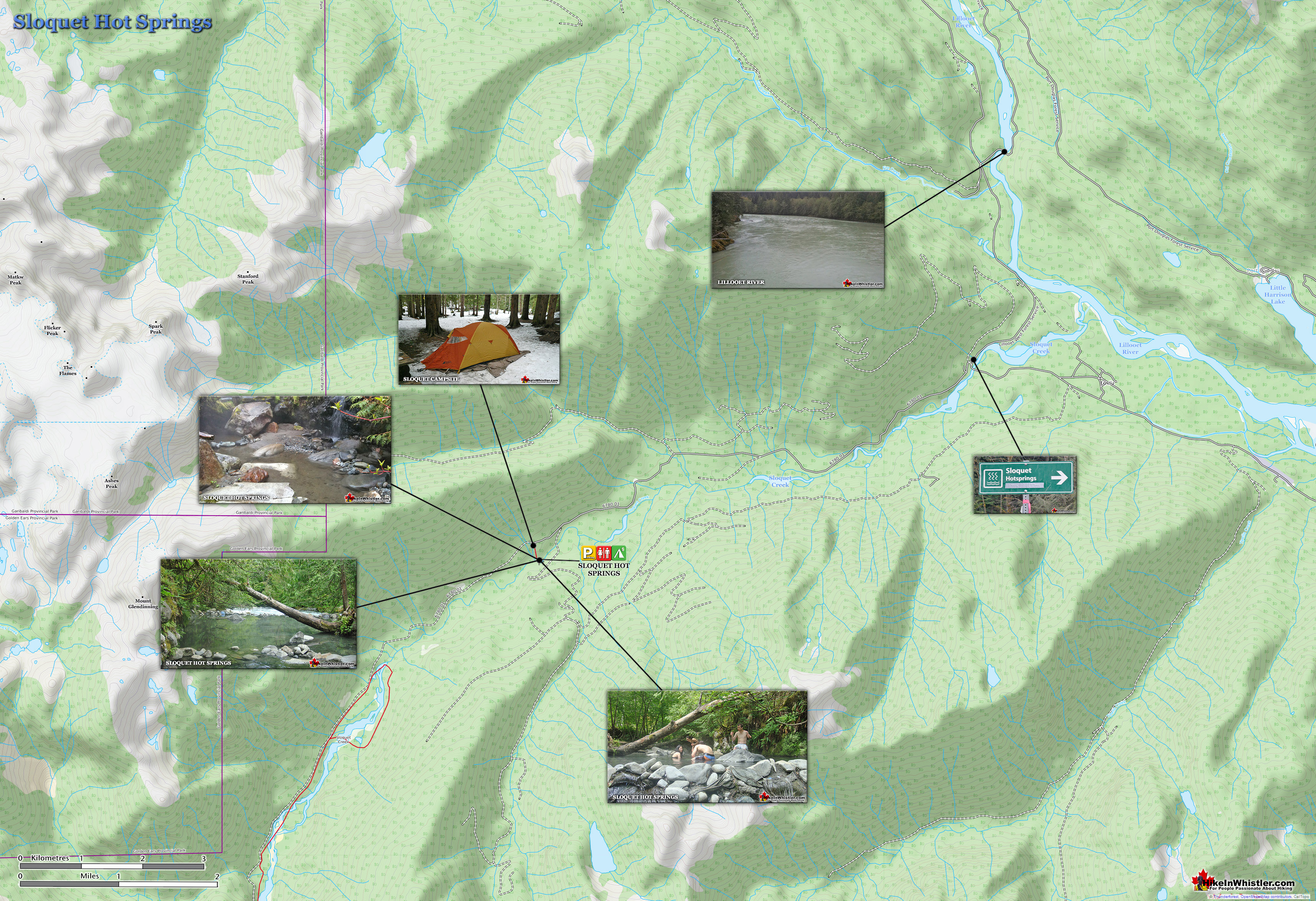
![]() From Whistler, zero your odometer in Whistler at Village Gate Boulevard and follow highway 99 (Sea to Sky Highway north toward Pemberton. At 32km you will arrive at Pemberton, an intersection, with a Petro Can gas station on your left and Mcdonalds to your right. Continue straight, through Pemberton. At 39km turn right at the sign to Lillooet(pictured left). Follow this winding road, for 10km and soon (5-10 minutes) you will come to the massive Lillooet Lake on your right. At 49km turn right, just as you pass the lake on your right you will see a sign for the In-Shuck-Ch Forest Service Road(pictured right). Continue down this logging road as it hugs the mighty Lillooet Lake on your right. At 78.8km you will come to a fork in the road. Bear left and you will immediately see another sign to the Skookumchuck Hot Springs. At 96.5km, on your right you will pass the sign welcoming you to "St. Agnes Well, T'sik, Skookumchuck Hot Springs" At 126.5km you will come to a slight fork in the road. Keep to the right and cross the massive bridge across Lillooet River. After a kilometre or so you will come to an intersection, turn left. At 131km you will see the sign to Sloquet Hot Springs. Turn right, then immediately left, follow this for 11km and look for the sign and entrance on your left for the Sloquet Hot Springs campsite. The trail to the hot springs descends quickly from the first big cluster of campsites on the left. Location 50°34.4' 123°28.0'.
From Whistler, zero your odometer in Whistler at Village Gate Boulevard and follow highway 99 (Sea to Sky Highway north toward Pemberton. At 32km you will arrive at Pemberton, an intersection, with a Petro Can gas station on your left and Mcdonalds to your right. Continue straight, through Pemberton. At 39km turn right at the sign to Lillooet(pictured left). Follow this winding road, for 10km and soon (5-10 minutes) you will come to the massive Lillooet Lake on your right. At 49km turn right, just as you pass the lake on your right you will see a sign for the In-Shuck-Ch Forest Service Road(pictured right). Continue down this logging road as it hugs the mighty Lillooet Lake on your right. At 78.8km you will come to a fork in the road. Bear left and you will immediately see another sign to the Skookumchuck Hot Springs. At 96.5km, on your right you will pass the sign welcoming you to "St. Agnes Well, T'sik, Skookumchuck Hot Springs" At 126.5km you will come to a slight fork in the road. Keep to the right and cross the massive bridge across Lillooet River. After a kilometre or so you will come to an intersection, turn left. At 131km you will see the sign to Sloquet Hot Springs. Turn right, then immediately left, follow this for 11km and look for the sign and entrance on your left for the Sloquet Hot Springs campsite. The trail to the hot springs descends quickly from the first big cluster of campsites on the left. Location 50°34.4' 123°28.0'.


Due to the year-round use of these logging roads, they are maintained by snowplows, however, the last 11 kilometres are not. Certainly from December to March this last section of road will have to be hiked with some difficulty. Often you can drive part of this section of road until the snow becomes too deep. There are plenty of wide areas to park or(turn around) out of the way of others attempting to drive to the campsite.
![]() Keyhole Hot Springs
Keyhole Hot Springs ![]() Meager Hot Springs
Meager Hot Springs ![]() Skookumchuck Hot Springs
Skookumchuck Hot Springs ![]() Sloquet Hot Springs
Sloquet Hot Springs
Whistler's Best Hiking Trails!
Whistler & Garibaldi Park Best Hiking by Month!


Explore BC Hiking Destinations!

Whistler Hiking Trails

Squamish Hiking Trails

Vancouver Hiking Trails

Clayoquot Hiking Trails
Victoria Hiking Trails

