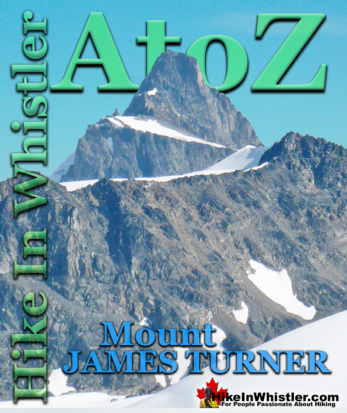
![]() If you make it to the summit of Wedge Mountain you will notice off in the distance a beautifully symmetrical mountain that stands out among the rest. Surrounded by glaciers on all sides, Mount James Turner has a striking cone shape to it. The third highest mountain in Garibaldi Provincial Park at 2703 metres(8868 feet), it is only surpassed by Wedge Mountain at 2892 metres(9488 feet) and Wedge's neighbour Mount Weart 2835 metres(9301 feet).
If you make it to the summit of Wedge Mountain you will notice off in the distance a beautifully symmetrical mountain that stands out among the rest. Surrounded by glaciers on all sides, Mount James Turner has a striking cone shape to it. The third highest mountain in Garibaldi Provincial Park at 2703 metres(8868 feet), it is only surpassed by Wedge Mountain at 2892 metres(9488 feet) and Wedge's neighbour Mount Weart 2835 metres(9301 feet).
Whistler & Garibaldi Hiking
![]() Alexander Falls
Alexander Falls ![]() Ancient Cedars
Ancient Cedars ![]() Black Tusk
Black Tusk ![]() Blackcomb Mountain
Blackcomb Mountain ![]() Brandywine Falls
Brandywine Falls ![]() Brandywine Meadows
Brandywine Meadows ![]() Brew Lake
Brew Lake ![]() Callaghan Lake
Callaghan Lake ![]() Cheakamus Lake
Cheakamus Lake ![]() Cheakamus River
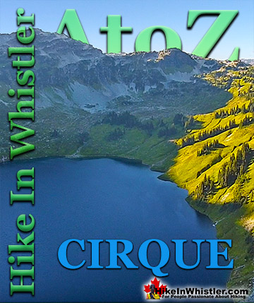
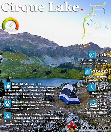
Cheakamus River ![]() Cirque Lake
Cirque Lake ![]() Flank Trail
Flank Trail ![]() Garibaldi Lake
Garibaldi Lake ![]() Garibaldi Park
Garibaldi Park ![]() Helm Creek
Helm Creek ![]() Jane Lakes
Jane Lakes ![]() Joffre Lakes
Joffre Lakes ![]() Keyhole Hot Springs
Keyhole Hot Springs ![]() Logger’s Lake
Logger’s Lake ![]() Madeley Lake
Madeley Lake ![]() Meager Hot Springs
Meager Hot Springs ![]() Nairn Falls
Nairn Falls ![]() Newt Lake
Newt Lake ![]() Panorama Ridge
Panorama Ridge ![]() Parkhurst Ghost Town
Parkhurst Ghost Town ![]() Rainbow Falls
Rainbow Falls ![]() Rainbow Lake
Rainbow Lake ![]() Ring Lake
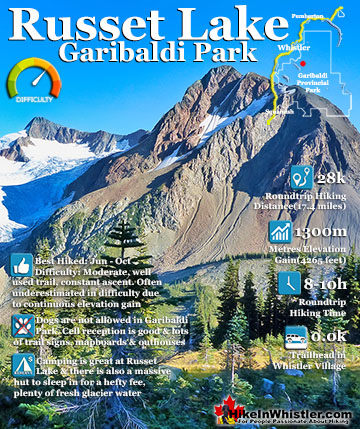
Ring Lake ![]() Russet Lake
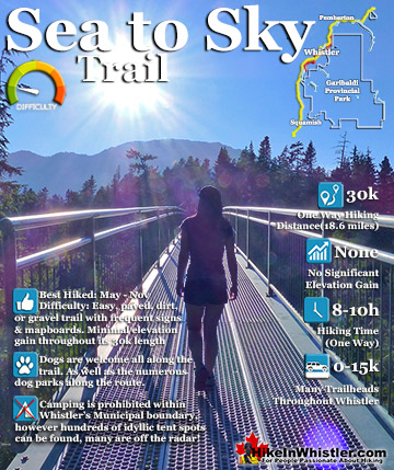
Russet Lake ![]() Sea to Sky Trail
Sea to Sky Trail ![]() Skookumchuck Hot Springs
Skookumchuck Hot Springs ![]() Sloquet Hot Springs
Sloquet Hot Springs ![]() Sproatt East
Sproatt East ![]() Sproatt West
Sproatt West ![]() Taylor Meadows
Taylor Meadows ![]() Train Wreck
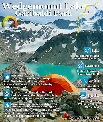
Train Wreck ![]() Wedgemount Lake
Wedgemount Lake ![]() Whistler Mountain
Whistler Mountain
![]() January
January ![]() February
February ![]() March
March ![]() April
April ![]() May
May ![]() June
June ![]() July
July ![]() August
August ![]() September
September ![]() October
October ![]() November
November ![]() December
December
Mount James Turner is quite a remote mountain in Garibaldi Park and takes about 8 hours to reach it from the Wedge-Weart Col. It can also be reached from Blackcomb Mountain via Wedge Pass. Either route involves quite a lot of technical skill and 2-4 days roundtrip. It was first climbed by Charles Townsend and Neal Carter in 1923. This remarkable expedition also recorded first ascents of Wedge Mountain and Mount Diavolo. The two also named several peaks and glaciers, including Mount James Turner, named after Reverend James Turner, a pioneer Methodist Minister well known in British Columbia and in the Yukon at the time and had recently passed away. Remarkably, this expedition was documented by Charles Townsend and photographed by Neal Carter. Despite the largely uncharted terrain which involved bushwhacking, large creek crossings, treacherous, unknown mountains and numerous glacier crossings, the story reads as a relatively mild walk in the woods. Certainly they were extremely tough, skilled and fearless mountaineers that had a love of exploring mountains that is inspiring to read. Hearing the word for word account gives you the beautiful sense that you are with them on their remarkably journey through these mountains as they were first climbed.
Mount James Turner from the Wedge-Weart Col

Charles Townsend's Account of the First Ascent of Wedge Mountain September 1923: Mr. Neal Carter and I had been planning all the summer to make the first ascent of Wedge Mountain as soon as we could get away in the fall. Accordingly, on Saturday evening September 8th, 1923 we landed with our belongings at Rainbow Lodge, our headquarters for the ensuing fortnight. The next morning, we left half our grub at the lodge, and with the rest of our belongings started out from Alta Lake. We followed the railway for 4 miles, travelled east along logging roads, then picked our way through the trees for another half mile until we finally reached Wedge Creek. The creek was much larger than we had expected and we were lucky in finding a log on which to cross. On the creeks east side, the hill rises sharply for about 800 feet. As the bush was thick, we were very glad to have a rest when we reached the top.

From there on the ridge is a series of thickly wooded bluffs. It was along this ridge that we caught our first glimpse of Wedge Mountain since the valley floor. Continuing upwards at about 5,000 feet elevation the trees began thinning out and giving place to open meadows. We were nearly all in when we finally found water near 6pm, at the extreme limits of the timberline and we made camp as quickly as possible. We were now in an ideal place for an attempt on Wedge Mountain and settled in for the night. Early the next morning we continued up the ridge however it soon came to an end and we found quite a gap in between us in the base of the mountain. We had to descend this gap and cross a number of ridges composed of masses of loose rocks, probably moraines at one time and then we crossed a small glacier before we got onto the climbable slopes of Wedge Mountain. We named this small glacier the Eclipse Glacier as shortly later we had a good view of a partial eclipse of the Sun. From there to the peak another 2,000 vertical feet we travelled over unstable talus slopes, the rocks being on average cubes of about two feet in thickness. The summit of the mountain is a long ridge ending in quite a sharp peak at the eastern end. It is very precipitous on three sides. We reach the summit at 1:15pm.

Owing to the clearness of the atmosphere we had a magnificent view and were able to secure some fine photographs. Immediately to the south of us was the Spearhead Range, which at this time remains practically unexplored. We were most impressed by it seven fine glaciers along its north side and the range’s potential for future mountaineering excursions was immediately apparent. To the east of us lay a peak which we resolved should be the object of our next climb. It lay across a valley from Wedge Mountain, and promised to be an enjoyable three-day trip. We thus returned to our previous camp and prepared for our next objective. The next day taking with us just enough food for three days and our bedding, leaving our tent behind. We hiked around the southern slopes of Wedge keeping just above the timberline to avoid the bush. To obtain water we had to drop down about 800 feet into the valley where we found a delightful camping spot. We lulled ourselves to sleep under the stars that night with soothing strains from the camp orchestra. The first part of our climb the next day brought us over four high ridges to an elevation of about 7,000 feet. From there we had a good view of Mount James Turner as Neil had named in memory of the Vancouver Reverend.
Charles Townsend Wedge Mountain First Ascent 10 Sept 1923

First View of Mt James Turner from Wedge Summit - 10 Sept 1923

Once across the quarry glacier we had to cross the Turner Glacier much larger than the former. We were now at the foot of the cliffs at the base of the peak. With some trouble owing to the extreme looseness of the rocks we climbed the cliffs to the east of the peak. From here we were ready for the final climb. The peak itself is a mass of jagged rock most of which is very loose and dangerous and I doubt whether it could be climbed from any other direction. An hour’s rock climbing took us to the summit arriving at 1:30pm. Once again, we had a magnificent view. On three sides the cliffs were very precipitous, while even the face up which we had come looked very steep from above. Still we descended and reach camp again at about 6pm. The next day we packed back to our first camp and the day following down to Alta Lake. The latter journey taking six hours. At Rainbow Lodge we had an excellent supper which partially made up for a week of dried goods.
More Whistler & Garibaldi Park Hiking A to Z!

The Best Whistler & Garibaldi Park Hiking Trails!
Whistler & Garibaldi Park Best Hiking by Month!


Explore BC Hiking Destinations!

Whistler Hiking Trails

Squamish Hiking Trails

Vancouver Hiking Trails

Clayoquot Hiking Trails
Victoria Hiking Trails

