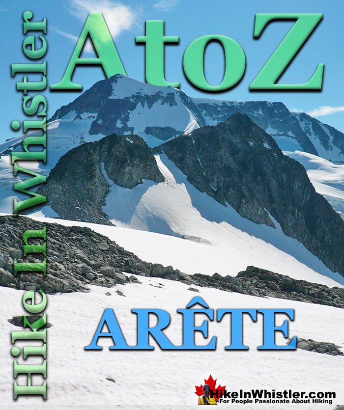
![]() Arête: a thin ridge of rock formed by two glaciers parallel to each other. Sometimes formed from two cirques meeting. From the French for edge or ridge. Around Whistler and in Garibaldi Provincial Park you will see dozens of excellent examples. At the Wedge-Weart Col above and beyond Wedgemount Lake is a prominent arête that links these two highest mountains in Garibaldi Park. Wedge Mountain is 2892 metres(9488 feet) and Mount Weart is 2835 metres(9301 feet).
Arête: a thin ridge of rock formed by two glaciers parallel to each other. Sometimes formed from two cirques meeting. From the French for edge or ridge. Around Whistler and in Garibaldi Provincial Park you will see dozens of excellent examples. At the Wedge-Weart Col above and beyond Wedgemount Lake is a prominent arête that links these two highest mountains in Garibaldi Park. Wedge Mountain is 2892 metres(9488 feet) and Mount Weart is 2835 metres(9301 feet).
Whistler & Garibaldi Hiking
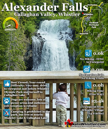
![]() Alexander Falls
Alexander Falls ![]() Ancient Cedars
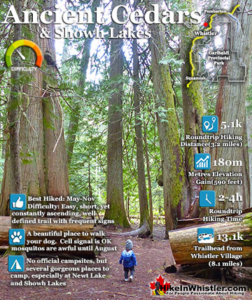
Ancient Cedars ![]() Black Tusk
Black Tusk ![]() Blackcomb Mountain
Blackcomb Mountain ![]() Brandywine Falls
Brandywine Falls ![]() Brandywine Meadows
Brandywine Meadows ![]() Brew Lake
Brew Lake ![]() Callaghan Lake
Callaghan Lake ![]() Cheakamus Lake
Cheakamus Lake ![]() Cheakamus River
Cheakamus River ![]() Cirque Lake
Cirque Lake ![]() Flank Trail
Flank Trail ![]() Garibaldi Lake
Garibaldi Lake ![]() Garibaldi Park
Garibaldi Park ![]() Helm Creek
Helm Creek ![]() Jane Lakes
Jane Lakes ![]() Joffre Lakes
Joffre Lakes ![]() Keyhole Hot Springs
Keyhole Hot Springs ![]() Logger’s Lake
Logger’s Lake ![]() Madeley Lake
Madeley Lake ![]() Meager Hot Springs
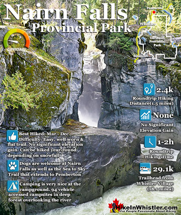
Meager Hot Springs ![]() Nairn Falls
Nairn Falls ![]() Newt Lake
Newt Lake ![]() Panorama Ridge
Panorama Ridge ![]() Parkhurst Ghost Town
Parkhurst Ghost Town ![]() Rainbow Falls
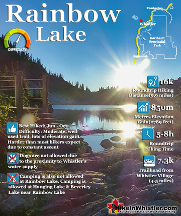
Rainbow Falls ![]() Rainbow Lake
Rainbow Lake ![]() Ring Lake
Ring Lake ![]() Russet Lake
Russet Lake ![]() Sea to Sky Trail
Sea to Sky Trail ![]() Skookumchuck Hot Springs
Skookumchuck Hot Springs ![]() Sloquet Hot Springs
Sloquet Hot Springs ![]() Sproatt East
Sproatt East ![]() Sproatt West
Sproatt West ![]() Taylor Meadows
Taylor Meadows ![]() Train Wreck
Train Wreck ![]() Wedgemount Lake
Wedgemount Lake ![]() Whistler Mountain
Whistler Mountain
![]() January
January ![]() February
February ![]() March
March ![]() April
April ![]() May
May ![]() June
June ![]() July
July ![]() August
August ![]() September
September ![]() October
October ![]() November
November ![]() December
December
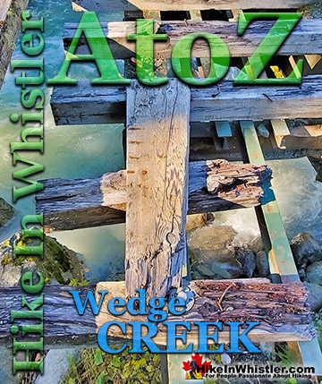
Wedgemount Lake is one of the most spectacular hikes in Garibaldi Provincial Park. Though it is a relentlessly exhausting, steep hike, it is mercifully short at only 7 kilometres. The elevation gain in that short distance is over 1200 metres, which makes it a much steeper hike than most other Whistler hiking trails. Compared with other Whistler hikes, Wedgemount Lake is half the roundtrip distance of either Black Tusk or Panorama Ridge, for example, at 13.5 kilometres and 15 kilometres respectively (one way). Wedgemount Lake itself is a magnificent destination for a day hike or spectacular overnight beneath the dazzling mountain peaks and stars. Many sleep under the stars on one of the many beautiful tent platforms that dot the landscape. Solidly built, wooden tent platforms are everywhere you look at Wedgemount Lake. Strategically positioned, these platforms manage to maintain an amazingly secluded feel despite their numbers. In all Wedgemount Lake has 20 of these tent areas. Most are wooden, but several down by the lake shore are gravel, yet every bit as nice. At a fast hiking pace you can reach Wedgemount Lake from the trailhead in just an hour and a half but at a leisurely or backpack laden pace you will likely take over two hours. The trail is well marked and well used. The steepness of the trail doesn't require any technical skill, however that last kilometre before the lake you will be scrambling on all fours quite a bit. The elevation gain makes a tremendous difference when carrying a heavy backpack and unprepared for the exertion. There is hardly a section of the trail that is not steeply uphill. The first 15 minutes takes you into the deep forest and along Wedgemount Creek. This crashing creek can be heard from quite a distance and gives you a hint of the steepness of the trail to come.
The Wedge Mountain North Arête
The prominent Wedge Mountain North Arête extends steeply down from the north face of Wedge Mountain to the Wedge-Weart Col. The arête then continues from the col up Mount Weart along a broad and crumbling scree route.


The Wedge-Weart Col
To hike up to the Wedge-Weart Col to get a close look at the Wedge Mountain North Arete is not technically difficult, however hiking on glaciers is always potentially dangerous. From the Wedgemount Lake hut you will see a trail descend down through the boulder field to the end of the lake. The trail bends around the end of the lake and fades away as you start ascending up towards Wedgemount Glacier.

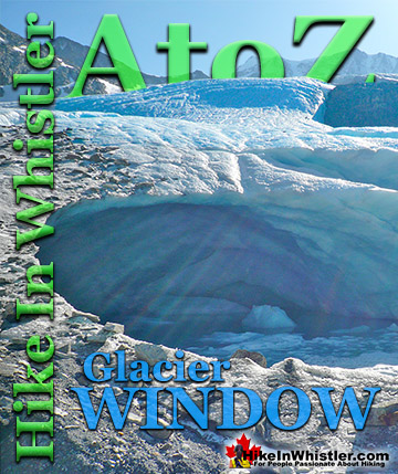
The impressive glacier window is the destination of most hikers following this route. On a glacier, the glacier window is where meltwater flows out and usually results in an impressively large ice cave.

Glaciers are so huge that it is hard to put the immense size into perspective. The above picture of Wedgemount Glacier makes the glacier window look quite small, however in the below picture its relative size can be appreciated.

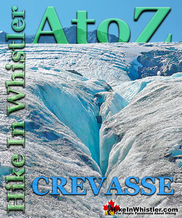
From the glacier window you can cautiously hike up the left side of Wedgemount Glacier. Partway up the glacier you will have to adjust your route more to the middle to avoid crevasses created by the bulging edge of Mount Weart. You will then see the broad glacier ascend to your left up to the prominent Wedge-Weart Col.

The below picture shows footprints in the snow on Wedgemount Glacier leading up to the Wedge-Weart Col, as the Wedge Mountain North Arête looms darkly on the right.

The final approach to the Wedge-Weart Col is over a broad and solid mass of Wedgemount Glacier with no crevasses.

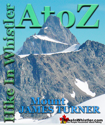
At the Wedge-Weart Col a sudden spectacular view is revealed. Mount James Turner lays prominently in the distance with its unmistakable triangular form.

Mount James Turner
A century ago when Wedge Mountain was first climbed by Neal Carter and Charles Townsend, they saw this mountain for the first time and make it their climbing objective for the following days. They reached the summit a couple days later and named the mountain after a well known, recently deceased Methodist Minister that travelled extensively through the wilderness of British Columbia and the Yukon.

Charles Townsend wrote about the mountaineering trip and this part starts as they near the summit of Wedge Mountain:
The summit of the mountain is a long ridge ending in quite a sharp peak at the eastern end. It is very precipitous on three sides. We reach the summit at 1:15pm. Owing to the clearness of the atmosphere we had a magnificent view and were able to secure some fine photographs. Immediately to the south of us was the Spearhead Range, which at this time remains practically unexplored. We were most impressed by it seven fine glaciers along its north side and the range’s potential for future mountaineering excursions was immediately apparent. To the east of us lay a peak which we resolved should be the object of our next climb. It lay across a valley from Wedge Mountain, and promised to be an enjoyable three-day trip. We thus returned to our previous camp and prepared for our next objective. The next day taking with us just enough food for three days and our bedding, leaving our tent behind. We hiked around the southern slopes of Wedge keeping just above the timberline to avoid the bush. To obtain water we had to drop down about 800 feet into the valley where we found a delightful camping spot. We lulled ourselves to sleep under the stars that night with soothing strains from the camp orchestra. The first part of our climb the next day brought us over four high ridges to an elevation of about 7,000 feet. From there we had a good view of Mount James Turner as Neil had named in memory of the Vancouver Reverend.


Below is a photo of Charles Townsend on the final approach to the summit of Wedge Mountain and on the right, Neal Carter on one of the many cliffs near the summit of Mount James Turner.

Wedge-Weart Col View of Arête and Wedge Mountain
Hiking up the huge glacier toward the Wedge-Weart Col, Wedge Mountain looks quite close to it. Once you reach the col you realize is it still quite far away, and separated by the jagged and dark North Arête. The following three pictures are from the Wedge-Weart Col, looking toward the North Arête and Wedge Mountain in the background. The second and third pictures are zoomed in to the summit of Wedge Mountain, the highest peak in Garibaldi Provincial Park.


Mount Weart and Armchair Glacier
From the Wedge-Weart Col looking to the north the Arête continues up towards Mount Weart, the second tallest mountain in Garibaldi Park. Mount Weart is often called by its original and more descriptive name, Armchair Mountain with Armchair Glacier stretching between the two armchair posts.


Wedgemount Lake Maps
Below is a map showing Wedgemount Lake from several vantage points. The upper tent pad view looking across to Wedgemount Glacier, an iceberg in July, the beautiful glacier window, the amazing view from the lower tent pads along Wedgemount Lake. The map also shows the various routes up Wedgemount Glacier to Wedge Mountain. These routes are potentially very dangerous and glacier travel is always unpredictable and hazardous, so make sure you know what you are doing before venturing beyond the glacier window.


For more information, maps and directions to Wedgemount Lake and the amazing Wedgemount Glacier, click here.
More Whistler & Garibaldi Park Hiking A to Z!


The Best Whistler & Garibaldi Park Hiking Trails!
Whistler & Garibaldi Park Best Hiking by Month!


Explore BC Hiking Destinations!

Whistler Hiking Trails

Squamish Hiking Trails

Vancouver Hiking Trails

Clayoquot Hiking Trails
Victoria Hiking Trails

