Hike in Whistler Glossary
Ablation Zones in Garibaldi Park, Whistler
![]() Ablation Zone: the lower altitude region of a glacier where there is a net loss of ice mass due to melting, sublimation, evaporation, ice calving or avalanche. The ablation zone of a glacier such as the Wedgemount Glacier has meltwater features such as englacial streams and a glacier window. An englacial stream refers to meltwater flowing inside a glacier. A glacier window is a cave-like opening at the mouth of a glacier where meltwater runs out. The ablation zone is located below the firn line. Firn originated from Swiss German and means "last year's snow". It has been compacted and recrystallized making it harder and more compact than snow, though less compact than glacial ice. A glacier such as the Wedgemount Glacier which stretches from Wedge Mountain down toward Wedgemount Lake, the ablation zone is very beautiful. A big pool of meltwater spills down the rock face and into turquoise coloured Wedgemount Lake. The pool of water is at the toe of Wedgemount Glacier and the large glacier window appears like a huge, gaping mouth. Big chunks of ice float in the pool and chunks of glacier split off into the water. Whistler and Garibaldi Park Geology: Ablation Zone continued...
Ablation Zone: the lower altitude region of a glacier where there is a net loss of ice mass due to melting, sublimation, evaporation, ice calving or avalanche. The ablation zone of a glacier such as the Wedgemount Glacier has meltwater features such as englacial streams and a glacier window. An englacial stream refers to meltwater flowing inside a glacier. A glacier window is a cave-like opening at the mouth of a glacier where meltwater runs out. The ablation zone is located below the firn line. Firn originated from Swiss German and means "last year's snow". It has been compacted and recrystallized making it harder and more compact than snow, though less compact than glacial ice. A glacier such as the Wedgemount Glacier which stretches from Wedge Mountain down toward Wedgemount Lake, the ablation zone is very beautiful. A big pool of meltwater spills down the rock face and into turquoise coloured Wedgemount Lake. The pool of water is at the toe of Wedgemount Glacier and the large glacier window appears like a huge, gaping mouth. Big chunks of ice float in the pool and chunks of glacier split off into the water. Whistler and Garibaldi Park Geology: Ablation Zone continued...

Accumulation Zones in Garibaldi Park, Whistler
![]() Accumulation Zone: the area where snow accumulations exceeds melt, located above the firn line. Snowfall accumulates faster than melting, evaporation and sublimation removes it. Glaciers can be shown simply as having two zones, the accumulation zone and the ablation zone. Separated by the glacier equilibrium line, these two zones comprise the areas of net annual gain and net annual loss of snow/ice on a glacier. The accumulation zone stretches from the higher elevations and pushes down, eventually reaching the ablation zone near the terminus of the glacier where the net loss of snow/ice exceeds the gain. The Wedgemount Glacier in Garibaldi Provincial Park in Whistler is an ideal place to see an accumulation zone up close. From across Wedgemount Lake you can see the overall picture of both the accumulation zone and ablation zone of a glacier. The Wedgemount Glacier is also relatively easy and safe to examine closely and hike onto. The left side of the glacier is frequented in the summer and fall months by experienced hikers on their way to Wedge Mountain and Mount Weart. Extreme caution is always needed and if you don't know how to remain safe while travelling on a glacier, you should avoid doing so. Whistler and Garibaldi Park Geology: Accumulation Zone continued...
Accumulation Zone: the area where snow accumulations exceeds melt, located above the firn line. Snowfall accumulates faster than melting, evaporation and sublimation removes it. Glaciers can be shown simply as having two zones, the accumulation zone and the ablation zone. Separated by the glacier equilibrium line, these two zones comprise the areas of net annual gain and net annual loss of snow/ice on a glacier. The accumulation zone stretches from the higher elevations and pushes down, eventually reaching the ablation zone near the terminus of the glacier where the net loss of snow/ice exceeds the gain. The Wedgemount Glacier in Garibaldi Provincial Park in Whistler is an ideal place to see an accumulation zone up close. From across Wedgemount Lake you can see the overall picture of both the accumulation zone and ablation zone of a glacier. The Wedgemount Glacier is also relatively easy and safe to examine closely and hike onto. The left side of the glacier is frequented in the summer and fall months by experienced hikers on their way to Wedge Mountain and Mount Weart. Extreme caution is always needed and if you don't know how to remain safe while travelling on a glacier, you should avoid doing so. Whistler and Garibaldi Park Geology: Accumulation Zone continued...

Adit Lakes in Garibaldi Park, Whistler
![]() Russet Lake sits in a wide, glacier carved valley at the base of The Fissile. In the direction opposite The Fissile, up on a plateau less than a kilometre away are two small tarns called Adit Lakes. Adit Lakes sit in a broad, boulder strewn alpine zone with an incredible view of Spearhead Range. Just a few metres from Adit Lakes the plateau drops off quickly into the huge valley that separates the Spearhead Range and Fitzsimmons Range. The Spearhead Range is named for its jagged array of spearhead shaped peaks that extend to include Blackcomb Mountain. Adit Lakes sit on a plateau in Fitzsimmons Range. From Adit Lakes you can look across the Musical Bumps all the way to the summit of Whistler Mountain. Musical Bumps is the collective name for the series of broad mountain peaks that have musical names. Viewed from Adit Lakes are Oboe Summit, Flute Summit and Piccolo Summit. The Singing Pass trail connects from the Musical Bumps trail and takes you down the valley between Whistler Mountain and Blackcomb Mountain to Whistler Village. The Singing Pass trail runs parallel to Fitzsimmons Creek which Adit Lakes drain into via Adit Creek. Fitzsimmons Creek is named after Jimmy Fitzsimmons who had a small cabin down in the valley near Fitzsimmons Creek. He was a miner that had a mining claim and hoped to find the other end of the copper vein that the Britannia Mine, opened in 1914, sat on. Adit Lakes are evidently named after the word miners use to describe a horizontal mine used to explore for mineral veins. The word adit comes from the latin aditus, which means entrance. Adits are dug into mountain ridges in the hopes of hitting the mineral vein or lode. Fitzsimmons was cutting adits here in the hopes of finding a vein of copper embedded between layers of rock. There are no visible traces of mining around Adit Lakes, but a few kilometres down the Singing Pass trail you can find remnants of old mine shafts. Whistler and Garibaldi Park Glossary: Adit Lakes continued...
Russet Lake sits in a wide, glacier carved valley at the base of The Fissile. In the direction opposite The Fissile, up on a plateau less than a kilometre away are two small tarns called Adit Lakes. Adit Lakes sit in a broad, boulder strewn alpine zone with an incredible view of Spearhead Range. Just a few metres from Adit Lakes the plateau drops off quickly into the huge valley that separates the Spearhead Range and Fitzsimmons Range. The Spearhead Range is named for its jagged array of spearhead shaped peaks that extend to include Blackcomb Mountain. Adit Lakes sit on a plateau in Fitzsimmons Range. From Adit Lakes you can look across the Musical Bumps all the way to the summit of Whistler Mountain. Musical Bumps is the collective name for the series of broad mountain peaks that have musical names. Viewed from Adit Lakes are Oboe Summit, Flute Summit and Piccolo Summit. The Singing Pass trail connects from the Musical Bumps trail and takes you down the valley between Whistler Mountain and Blackcomb Mountain to Whistler Village. The Singing Pass trail runs parallel to Fitzsimmons Creek which Adit Lakes drain into via Adit Creek. Fitzsimmons Creek is named after Jimmy Fitzsimmons who had a small cabin down in the valley near Fitzsimmons Creek. He was a miner that had a mining claim and hoped to find the other end of the copper vein that the Britannia Mine, opened in 1914, sat on. Adit Lakes are evidently named after the word miners use to describe a horizontal mine used to explore for mineral veins. The word adit comes from the latin aditus, which means entrance. Adits are dug into mountain ridges in the hopes of hitting the mineral vein or lode. Fitzsimmons was cutting adits here in the hopes of finding a vein of copper embedded between layers of rock. There are no visible traces of mining around Adit Lakes, but a few kilometres down the Singing Pass trail you can find remnants of old mine shafts. Whistler and Garibaldi Park Glossary: Adit Lakes continued...

Aiguilles in Garibaldi Park, Whistler
![]() Aiguille: a tall, narrow, characteristically distinct spire of rock. From the French word for "needle". Used extensively as part of the names for many peaks in the French Alps. Around Whistler and in Garibaldi Park you will find several distinct aiguilles. Shown here is the prominent aiguille that stands like a tower at the summit of Rethel Mountain above Wedgemount Lake. Standing near the hut at Wedgemount Lake, Rethel is the towering mountain directly across the lake. If you are looking at Wedge Mountain from Whistler Village, Rethel Mountain is the second mountain to the left of Wedge. In order they are Wedge Mountain, Parkhurst Mountain and Rethel Mountain. Parkhurst Mountain stretches down the valley to Parkhurst Ghost Town at the shore of Green Lake. Across Wedgemount Lake and still visible from Whistler are Mount Weart, Armchair Glacier and Cook Mountain. If you are new to Whistler and are unfamiliar with Wedge Mountain, it is the strikingly wedge-shaped mountain that dominates the skyline from many places in Whistler. Whistler and Garibaldi Park Geology: Aiguille continued...
Aiguille: a tall, narrow, characteristically distinct spire of rock. From the French word for "needle". Used extensively as part of the names for many peaks in the French Alps. Around Whistler and in Garibaldi Park you will find several distinct aiguilles. Shown here is the prominent aiguille that stands like a tower at the summit of Rethel Mountain above Wedgemount Lake. Standing near the hut at Wedgemount Lake, Rethel is the towering mountain directly across the lake. If you are looking at Wedge Mountain from Whistler Village, Rethel Mountain is the second mountain to the left of Wedge. In order they are Wedge Mountain, Parkhurst Mountain and Rethel Mountain. Parkhurst Mountain stretches down the valley to Parkhurst Ghost Town at the shore of Green Lake. Across Wedgemount Lake and still visible from Whistler are Mount Weart, Armchair Glacier and Cook Mountain. If you are new to Whistler and are unfamiliar with Wedge Mountain, it is the strikingly wedge-shaped mountain that dominates the skyline from many places in Whistler. Whistler and Garibaldi Park Geology: Aiguille continued...

Alpine Zones in Garibaldi Park, Whistler
![]() Alpine Zone or Alpine Tundra is the area above the treeline, often characterized by stunted, sparse forests of krummholz and pristine, turquoise lakes. Mount Sproatt is an excellent example of an alpine zone in Whistler. Dozens of alpine lakes, rugged and rocky terrain and hardy krummholz trees everywhere you look. The hostile, cold and windy climate in the alpine zones around Whistler make tree growth difficult. Added to that, the alpine areas are snow covered the majority of the year. Other good places to explore alpine zones in Whistler and Garibaldi Park are Wedgemount Lake, Blackcomb Mountain, Whistler Mountain, Black Tusk, Brandywine Meadows, Brew Lake, Callaghan Lake Provincial Park, and quite a lot more. Located within sight of Whistler Village, Wedge Mountain is the highest mountain in Garibaldi Provincial Park. Just a relatively short, 7 kilometre hike takes you to this mountain paradise of impossibly turquoise water and jagged mountain peaks all around. The shortness of the hike to Wedgemount Lake lulls hikers into thinking it is an easy trail. Whistler and Garibaldi Park Geology: Alpine Zone Continued...
Alpine Zone or Alpine Tundra is the area above the treeline, often characterized by stunted, sparse forests of krummholz and pristine, turquoise lakes. Mount Sproatt is an excellent example of an alpine zone in Whistler. Dozens of alpine lakes, rugged and rocky terrain and hardy krummholz trees everywhere you look. The hostile, cold and windy climate in the alpine zones around Whistler make tree growth difficult. Added to that, the alpine areas are snow covered the majority of the year. Other good places to explore alpine zones in Whistler and Garibaldi Park are Wedgemount Lake, Blackcomb Mountain, Whistler Mountain, Black Tusk, Brandywine Meadows, Brew Lake, Callaghan Lake Provincial Park, and quite a lot more. Located within sight of Whistler Village, Wedge Mountain is the highest mountain in Garibaldi Provincial Park. Just a relatively short, 7 kilometre hike takes you to this mountain paradise of impossibly turquoise water and jagged mountain peaks all around. The shortness of the hike to Wedgemount Lake lulls hikers into thinking it is an easy trail. Whistler and Garibaldi Park Geology: Alpine Zone Continued...

Arborlith and Lithophytes in Garibaldi Park, Whistler
![]() Every unusual phenomenon in the forest seems to have a name, but one natural work of art seems to be without a commonly used name. Big trees with sprawling roots that wrap around huge boulders, glacier erratics or jagged bedrock are sometimes called lithophytes which translates from Latin lith and phyte as stone and plant. Lithophyte is not the best description for these because they don't so much live on rock as encompass it. Lithophyte is widely used to refer to a plant that grows on or out of a rock, but doesn’t seem accurate to describe a tree that grows over and engulfs a rock. A lithophyte grows on solid rock or in the cracks of massive boulders and therefor survives on nutrients derived from these regions. The big trees in the forest we are talking about don’t survive on or in the rock itself, but rather treat it as an obstacle and grow mighty roots over, around and under it. Decades of water erosion may have washed away soil that once allowed a tree to grow on what now appears as solid rock. This seems to be the origin of the big western hemlock on the Cheakamus Lake trail that is growing on a house sized boulder that likely tumbled down from Whistler Mountain a century ago. One side of the boulder is mostly solid rock, whereas the side with the tree growing over it is disintegrating it into smaller boulders under the vice grip of roots and tremendous weight pressing down from above.
Every unusual phenomenon in the forest seems to have a name, but one natural work of art seems to be without a commonly used name. Big trees with sprawling roots that wrap around huge boulders, glacier erratics or jagged bedrock are sometimes called lithophytes which translates from Latin lith and phyte as stone and plant. Lithophyte is not the best description for these because they don't so much live on rock as encompass it. Lithophyte is widely used to refer to a plant that grows on or out of a rock, but doesn’t seem accurate to describe a tree that grows over and engulfs a rock. A lithophyte grows on solid rock or in the cracks of massive boulders and therefor survives on nutrients derived from these regions. The big trees in the forest we are talking about don’t survive on or in the rock itself, but rather treat it as an obstacle and grow mighty roots over, around and under it. Decades of water erosion may have washed away soil that once allowed a tree to grow on what now appears as solid rock. This seems to be the origin of the big western hemlock on the Cheakamus Lake trail that is growing on a house sized boulder that likely tumbled down from Whistler Mountain a century ago. One side of the boulder is mostly solid rock, whereas the side with the tree growing over it is disintegrating it into smaller boulders under the vice grip of roots and tremendous weight pressing down from above.

In other circumstances heavy snow of winter may bend a tree growing on a steep slope over a boulder for several years until it grows strong enough to resist the weight of snow and grow straight up. An excellent example of this can be found on the trail to Newt Lake in Whistler. In this case a fridge sized boulder on a hillside had a western hemlock crushed against it under snow for several years until it could resist the snow and grow upward. Now a decades old tree, it appears to be growing out of the middle of a big round boulder. Only when you walk around to look at it from the side do you notice the large tree trunk bending around the rock and into the ground. It doesn’t seem accurate to call either of these two trees lithophytes. As Steven Engelhart points out, “Lithophytes are plants that grown in or on rocks but most of these seem to take their nutrition from their immediate rock environment and not by extending their roots into the ground.” He suggest the word arborlith as a more accurate term for these amazing trees. Arbor is Latin for tree and lith translates as stone. Arborlith Lithophyte continued here...
Arêtes in Garibaldi Park, Whistler
![]() Arête: a thin ridge of rock formed by two glaciers parallel to each other. Sometimes formed from two cirques meeting. From the French for edge or ridge. Around Whistler and in Garibaldi Provincial Park you will see dozens of excellent examples. At the Wedge-Weart Col above and beyond Wedgemount Lake is a prominent arête that links these two of Garibaldi Park's highest mountains in. Wedge Mountain is 2892 metres(9488 feet) and Mount Weart is 2835 metres(9301 feet). Wedgemount Lake is one of the most spectacular hikes in Garibaldi Provincial Park. Though it is a relentlessly exhausting, steep hike, it is mercifully short at only 7 kilometres. The elevation gain in that short distance is over 1200 metres, which makes it a much steeper hike than most other Whistler hiking trails. Whistler and Garibaldi Park Geology: Arete Continued...
Arête: a thin ridge of rock formed by two glaciers parallel to each other. Sometimes formed from two cirques meeting. From the French for edge or ridge. Around Whistler and in Garibaldi Provincial Park you will see dozens of excellent examples. At the Wedge-Weart Col above and beyond Wedgemount Lake is a prominent arête that links these two of Garibaldi Park's highest mountains in. Wedge Mountain is 2892 metres(9488 feet) and Mount Weart is 2835 metres(9301 feet). Wedgemount Lake is one of the most spectacular hikes in Garibaldi Provincial Park. Though it is a relentlessly exhausting, steep hike, it is mercifully short at only 7 kilometres. The elevation gain in that short distance is over 1200 metres, which makes it a much steeper hike than most other Whistler hiking trails. Whistler and Garibaldi Park Geology: Arete Continued...

A River Runs Through It
![]() Twentyone Mile Creek begins its long and steep journey from Rainbow Lake, high up and between Mount Sproatt and Rainbow Mountain. Cutting between the two mountains, Twentyone Mile Creek flattens out somewhat, passes under Alta Lake Road, then winds its way through a deep and dark forest before flowing into the River of Golden Dreams near the end of Lorimer Road. This hidden forest extends from Rainbow Park to Emerald Forest and between Alta Lake Road and the River of Golden Dreams. If you look closely at one of the parking lots in Rainbow Park, you will see a small trail sign for the wonderful trail that takes you through this secluded forest, all the way to Emerald Forest. A River Runs Through It is an insanely winding trail that follows a dizzying route through this captivating forest with Twentyone Mile Creek running through it. A popular, though brutally challenging bike trail, A River Runs Through It has numerous, elaborate ramps, small bridges, and one large bridge that spans Twentyone Mile Creek. A River Runs Through It has a couple shortcut trails that cut a couple kilometres off of it to make it a more manageable and enjoyable hiking trail. If you add in another two connecting trails, you can turn A River Runs Through It into a beautiful 6 kilometre circle route. ARRTI continued here...
Twentyone Mile Creek begins its long and steep journey from Rainbow Lake, high up and between Mount Sproatt and Rainbow Mountain. Cutting between the two mountains, Twentyone Mile Creek flattens out somewhat, passes under Alta Lake Road, then winds its way through a deep and dark forest before flowing into the River of Golden Dreams near the end of Lorimer Road. This hidden forest extends from Rainbow Park to Emerald Forest and between Alta Lake Road and the River of Golden Dreams. If you look closely at one of the parking lots in Rainbow Park, you will see a small trail sign for the wonderful trail that takes you through this secluded forest, all the way to Emerald Forest. A River Runs Through It is an insanely winding trail that follows a dizzying route through this captivating forest with Twentyone Mile Creek running through it. A popular, though brutally challenging bike trail, A River Runs Through It has numerous, elaborate ramps, small bridges, and one large bridge that spans Twentyone Mile Creek. A River Runs Through It has a couple shortcut trails that cut a couple kilometres off of it to make it a more manageable and enjoyable hiking trail. If you add in another two connecting trails, you can turn A River Runs Through It into a beautiful 6 kilometre circle route. ARRTI continued here...

Armchair Glacier in Garibaldi Park, Whistler
![]() Armchair Glacier is one of the many easily identifiable mountain features around Whistler. Along with Wedge Mountain and Black Tusk, Armchair Glacier has a distinct shape that it is named after. Armchair Glacier can be seen from a considerable distance and from many places in Whistler. In the winter it is a solid white ridge with three peaks and in the summer the ridge and peaks are bare rock and the glacier can be seen as a solid, horizontal line below. The three-peak mountain ridge above Armchair Glacier is actually called Mount Weart. Despite its distinct armchair appearance and it being known for decades as Armchair Mountain, or simply Armchair, in 1930 the Garibaldi Park Board officially had the name changed to Mount Weart. John Walter Weart(1861-1941) was a lawyer, politician and the chairman of the Garibaldi Park Board at the time of the name change. Though officially called Mount Weart by the Geographical Names Board of Canada, the original name Armchair is still almost universally used. Armchair Glacier continued here...
Armchair Glacier is one of the many easily identifiable mountain features around Whistler. Along with Wedge Mountain and Black Tusk, Armchair Glacier has a distinct shape that it is named after. Armchair Glacier can be seen from a considerable distance and from many places in Whistler. In the winter it is a solid white ridge with three peaks and in the summer the ridge and peaks are bare rock and the glacier can be seen as a solid, horizontal line below. The three-peak mountain ridge above Armchair Glacier is actually called Mount Weart. Despite its distinct armchair appearance and it being known for decades as Armchair Mountain, or simply Armchair, in 1930 the Garibaldi Park Board officially had the name changed to Mount Weart. John Walter Weart(1861-1941) was a lawyer, politician and the chairman of the Garibaldi Park Board at the time of the name change. Though officially called Mount Weart by the Geographical Names Board of Canada, the original name Armchair is still almost universally used. Armchair Glacier continued here...

The Barrier in Garibaldi Park
![]() The Barrier formed as a result of huge lava flows from Clinker Peak on the west shoulder of Mount Price during the last ice age. About thirteen thousand years ago, the Cheakamus River valley was filled by an enormous glacier, part of the Cordilleran Ice Sheet. Lava flowed from Clinker Peak and pressed up against the massive glacier. The lava ponded and formed what geologists call an ice-marginal lava flow. An ice-marginal lava flow is interesting because it causes the lava flow that pools against the glacier to cool relatively quickly forming a solid, rock barrier. Behind this barrier of rock, a lava pool forms. As the glacier retreats as it did after the last ice age, this barrier remains and is characterized as large, steep and unstable. The Barrier was formed in this way from this massive lava flow from Clinker Peak. The lava flow has been studied in detail and four “lobes” have been identified. The First Lobe, closest to Clinker Peak pushes into Garibaldi Lake separating Price Bay from the Garibaldi Lake campground. The Second Lobe covers the area separating Garibaldi Lake from Lesser Garibaldi Lake and is the lobe that created Garibaldi Lake. The Third Lobe formed The Barrier and created Lesser Garibaldi Lake. The Fourth Lobe extends from The Barrier and can be seen today as the very abrupt cliffs along the opposite side of the Rubble Creek valley. The Barrier continued here...
The Barrier formed as a result of huge lava flows from Clinker Peak on the west shoulder of Mount Price during the last ice age. About thirteen thousand years ago, the Cheakamus River valley was filled by an enormous glacier, part of the Cordilleran Ice Sheet. Lava flowed from Clinker Peak and pressed up against the massive glacier. The lava ponded and formed what geologists call an ice-marginal lava flow. An ice-marginal lava flow is interesting because it causes the lava flow that pools against the glacier to cool relatively quickly forming a solid, rock barrier. Behind this barrier of rock, a lava pool forms. As the glacier retreats as it did after the last ice age, this barrier remains and is characterized as large, steep and unstable. The Barrier was formed in this way from this massive lava flow from Clinker Peak. The lava flow has been studied in detail and four “lobes” have been identified. The First Lobe, closest to Clinker Peak pushes into Garibaldi Lake separating Price Bay from the Garibaldi Lake campground. The Second Lobe covers the area separating Garibaldi Lake from Lesser Garibaldi Lake and is the lobe that created Garibaldi Lake. The Third Lobe formed The Barrier and created Lesser Garibaldi Lake. The Fourth Lobe extends from The Barrier and can be seen today as the very abrupt cliffs along the opposite side of the Rubble Creek valley. The Barrier continued here...

In the spring of 1856 more than 25 million cubic metres of rock from The Barrier crashed down the valley of what is today called Rubble Creek. The incredible torrent of volcanic rock boulders crashed down the valley more than 6 kilometres at a speed of more than 30 metres per second. The vertical distance of the debris flow was over 1000 metres measured from the top of The Barrier to the end of the debris field where Rubble Creek meets Cheakamus River. Whistler and Garibaldi Park Geology: The Barrier Continued...
Battleship Islands in Garibaldi Park
![]() The rocky and narrow row of islands in Garibaldi Lake just offshore from the Garibaldi Lake campsite are known as Battleship Islands. Named by the prolific mountaineer Neal Carter in 1927 "..because they are a group of tiny islands with often a single tree as a mast, presenting the appearance of boats, as viewed from Panorama Point(a lookout on Panorama Ridge)." The name "The Battleship Islands" originally appeared on AJ Campbell's 1928 map of Garibaldi Provincial Park. Garibaldi Park maps since 1957 have officially shortened the name to Battleship Islands. Battleship Islands continued here...
The rocky and narrow row of islands in Garibaldi Lake just offshore from the Garibaldi Lake campsite are known as Battleship Islands. Named by the prolific mountaineer Neal Carter in 1927 "..because they are a group of tiny islands with often a single tree as a mast, presenting the appearance of boats, as viewed from Panorama Point(a lookout on Panorama Ridge)." The name "The Battleship Islands" originally appeared on AJ Campbell's 1928 map of Garibaldi Provincial Park. Garibaldi Park maps since 1957 have officially shortened the name to Battleship Islands. Battleship Islands continued here...

Bears in Whistler & Garibaldi Park
![]() Whistler, the surrounding mountains, and Garibaldi Provincial Park are home to two types of bears. Black bears and grizzly bears. Black bears are frequently seen throughout the valley and often in Whistler Village. Grizzly bears, on the other hand, are rarely seen, and only deep in the wilderness, well away from Whistler Village. Black bears around Whistler are generally skittish and will flee into the forest when approached by people. Unlike grizzly bears, black bears are usually shy and rarely aggressive toward people. If you surprise a bear, make it feel trapped or get too close, you may get swiped with a claw as the bear escapes. To avoid conflicts with black bears, one method is to make yourself known. For example, if hiking in the forest a bear bell is a good way to announce your approach to bears in the area. Bears have tremendously good hearing so your foot steps should alert bears to your presence. If you encounter a black bear in Whistler, you should make yourself heard and seen without being threatening. Talk in a calm voice and back away from the bear slowly. Black bear attacks tend to be entirely the fault of the humans involved. Whether a person doesn’t back away, but tries to get closer, or tries to feed a bear. Or a combination of these. In Whistler, if garbage is not secured and bear proof, it will eventually attract a bear to tear it apart. Then, a person will accidentally or purposely get too close and trigger a panicked attack from the bear. Black bear attacks in Whistler always seem to be of this type, however even these are extremely rare.
Whistler, the surrounding mountains, and Garibaldi Provincial Park are home to two types of bears. Black bears and grizzly bears. Black bears are frequently seen throughout the valley and often in Whistler Village. Grizzly bears, on the other hand, are rarely seen, and only deep in the wilderness, well away from Whistler Village. Black bears around Whistler are generally skittish and will flee into the forest when approached by people. Unlike grizzly bears, black bears are usually shy and rarely aggressive toward people. If you surprise a bear, make it feel trapped or get too close, you may get swiped with a claw as the bear escapes. To avoid conflicts with black bears, one method is to make yourself known. For example, if hiking in the forest a bear bell is a good way to announce your approach to bears in the area. Bears have tremendously good hearing so your foot steps should alert bears to your presence. If you encounter a black bear in Whistler, you should make yourself heard and seen without being threatening. Talk in a calm voice and back away from the bear slowly. Black bear attacks tend to be entirely the fault of the humans involved. Whether a person doesn’t back away, but tries to get closer, or tries to feed a bear. Or a combination of these. In Whistler, if garbage is not secured and bear proof, it will eventually attract a bear to tear it apart. Then, a person will accidentally or purposely get too close and trigger a panicked attack from the bear. Black bear attacks in Whistler always seem to be of this type, however even these are extremely rare.

There has never been an unprovoked bear attack in Whistler and the provoked bear attacks result in minor scratches from a claw swipe. Your best strategy if you find yourself in a close up conflict with a black bear is to back away if you can or fight back. Playing dead will not help you with a black bear, however playing dead has been known to work with grizzly bears. Whistler and Garibaldi Park Glossary: bears continued here...
Bench: Whistler & Garibaldi Park Geology
![]() Bench: a flat section in steep terrain. Characteristically narrow, flat or gently sloping with steep or vertical slopes on either side. A bench can be formed by various geological processes. Natural erosion of a landscape often results in a bench being formed out of a hard strip of rock edged by softer, sedimentary rock. The softer rock erodes over time, leaving a narrow strip of rock resulting in a bench. Coastal benches form out of continuous wave erosion of a coastline. Cutting away at a coastline can result in vertical cliffs dozens or hundreds of metres high with a distinct bench form. Often a bench takes the form of a long, flat top ridge. Panorama Ridge in Garibaldi Provincial Park is an excellent example of a bench. The Musical Bumps trail on Whistler Mountain is another good example of bench formations. Each "bump" along the Musical Bumps trail is effectively a bench. Russet Lake in Garibaldi Provincial Park has a prominent bench adjacent to it. The bench separates Russet Lake and Adit Lakes. Adit Lakes are two idyllic little tarns in a hidden valley separated from the much busier Russet Lake valley by this bench. Whistler and Garibaldi Park Geology: bench continued here...
Bench: a flat section in steep terrain. Characteristically narrow, flat or gently sloping with steep or vertical slopes on either side. A bench can be formed by various geological processes. Natural erosion of a landscape often results in a bench being formed out of a hard strip of rock edged by softer, sedimentary rock. The softer rock erodes over time, leaving a narrow strip of rock resulting in a bench. Coastal benches form out of continuous wave erosion of a coastline. Cutting away at a coastline can result in vertical cliffs dozens or hundreds of metres high with a distinct bench form. Often a bench takes the form of a long, flat top ridge. Panorama Ridge in Garibaldi Provincial Park is an excellent example of a bench. The Musical Bumps trail on Whistler Mountain is another good example of bench formations. Each "bump" along the Musical Bumps trail is effectively a bench. Russet Lake in Garibaldi Provincial Park has a prominent bench adjacent to it. The bench separates Russet Lake and Adit Lakes. Adit Lakes are two idyllic little tarns in a hidden valley separated from the much busier Russet Lake valley by this bench. Whistler and Garibaldi Park Geology: bench continued here...

Bergschrund or Schrund in Garibaldi Park
![]() Bergschrund or abbreviated schrund: a crevasse that forms from the separation of moving glacier ice from the stagnant ice above. Characterized by a deep cut, horizontal, along a steep slope. Often extending extremely deep, over 100 metres down to bedrock. Extremely dangerous as they are filled in winter by avalanches and gradually open in the summer. The Wedgemount Glacier at Wedgemount Lake is a great and relatively safe way to view bergschrund near Whistler. At the far end of Wedgemount Lake the beautiful glacier window can be seen with water flowing down into the lake. From the scree field below the glacier you can see the crumbling bergschrund separate and fall away from the glacier. Up on the glacier you fill find several crevasses. Many are just a few centimetres wide, though several metres deep. Hiking along the left side of the glacier is relatively safe, however the right size of the glacier is extremely dangerous as the bergschrund vary in width and can be measure only in metres instead of centimetres. Hikers venturing up the glacier are advised to keep far to the left or only at the safe, lower edges near the glacier window. Whistler and Garibaldi Park Geology: bergschrund continued here...
Bergschrund or abbreviated schrund: a crevasse that forms from the separation of moving glacier ice from the stagnant ice above. Characterized by a deep cut, horizontal, along a steep slope. Often extending extremely deep, over 100 metres down to bedrock. Extremely dangerous as they are filled in winter by avalanches and gradually open in the summer. The Wedgemount Glacier at Wedgemount Lake is a great and relatively safe way to view bergschrund near Whistler. At the far end of Wedgemount Lake the beautiful glacier window can be seen with water flowing down into the lake. From the scree field below the glacier you can see the crumbling bergschrund separate and fall away from the glacier. Up on the glacier you fill find several crevasses. Many are just a few centimetres wide, though several metres deep. Hiking along the left side of the glacier is relatively safe, however the right size of the glacier is extremely dangerous as the bergschrund vary in width and can be measure only in metres instead of centimetres. Hikers venturing up the glacier are advised to keep far to the left or only at the safe, lower edges near the glacier window. Whistler and Garibaldi Park Geology: bergschrund continued here...

Bivouac or Bivy: Glossary of Whistler
![]() Bivouac or Bivy: a primitive campsite or simple, flat area where camping is possible. Traditionally used to refer to a very primitive campsite comprised of natural materials found on site such as leaves and branches or simply sleeping under the stars. Often used interchangeably with the word camp, however, bivouac implies a shorter, quicker and much more basic and naturally constructed camp setup. For example, at the Taylor Meadows campground in Garibaldi Park, camping is the appropriately used term to describe sleeping there at night as you have constructed tent platforms and are using a tent. If instead you plan to sleep on the summit of Black Tusk, bivouacking would be more accurately used to describe what you are doing as you are not using a tent. In the warm summer months around Whistler you will find people bivouacking under the stars in various places with just a sleeping bag. Whistler and Garibaldi Park Glossary: bivouac continued here...
Bivouac or Bivy: a primitive campsite or simple, flat area where camping is possible. Traditionally used to refer to a very primitive campsite comprised of natural materials found on site such as leaves and branches or simply sleeping under the stars. Often used interchangeably with the word camp, however, bivouac implies a shorter, quicker and much more basic and naturally constructed camp setup. For example, at the Taylor Meadows campground in Garibaldi Park, camping is the appropriately used term to describe sleeping there at night as you have constructed tent platforms and are using a tent. If instead you plan to sleep on the summit of Black Tusk, bivouacking would be more accurately used to describe what you are doing as you are not using a tent. In the warm summer months around Whistler you will find people bivouacking under the stars in various places with just a sleeping bag. Whistler and Garibaldi Park Glossary: bivouac continued here...

Blackcomb Mountain: Glossary of Whistler
![]() Blackcomb Mountain along with Whistler Mountain make up WhistlerBlackcomb Ski Resort, arguably the largest ski resort in North America. Blackcomb Mountain gets it name from its serrated, comb-like edge of black rock along its summit. It is thought to have been named by Don and Phyllis Munday who first climbed it in 1923. In A Passion for the Mountains: The Lives of Don and Phyllis Munday, Kathryn Bridge quotes the explorers, "Then we climbed up and built a small cairn as there was no sign of previous climbers. We suggested the descriptive name of Mt. Blackcomb. The elevation was apparently about 8,000 feet. The time was 2pm." Neal Carter credited the Munday's with naming Blackcomb Peak in 1927 when he submitted the name for the new Garibaldi Park map being created by A.J. Campbell. Carter wrote that it was "Descriptive of the serrated edge of black rock at the summit." It has also been suggested that the name was already in use previous to Don and Phyllis Munday's first ascent in 1923. An unattributed anecdote provided to the Whistler Museum in 2011 credits Alex Philip as coming up with the name. Alex and Myrtle Philip founded Rainbow Lodge in 1914, and it seems unusual that one of the three prominent mountains directly across Alta Lake from the lodge would have remained unnamed for almost a decade. Wedge Mountain and Whistler Mountain are on either side of Blackcomb Mountain and their names had long been in use by the few residents of Alta Lake. A photograph at the Whistler Museum of Jimmy Fitzsimmons that is thought to be taken in 1916 with an interesting caption on the back that reads “..man packing dynamite up to Fitzsimmons Mine(half way up Blackcomb)”. Unfortunately the date and writer of the caption remains unknown and could have been written decades after the picture was taken. So the reference to Blackcomb is still unconfirmed to predate the naming by Don and Phyllis Munday in 1923. Blackcomb Mountain continued here...
Blackcomb Mountain along with Whistler Mountain make up WhistlerBlackcomb Ski Resort, arguably the largest ski resort in North America. Blackcomb Mountain gets it name from its serrated, comb-like edge of black rock along its summit. It is thought to have been named by Don and Phyllis Munday who first climbed it in 1923. In A Passion for the Mountains: The Lives of Don and Phyllis Munday, Kathryn Bridge quotes the explorers, "Then we climbed up and built a small cairn as there was no sign of previous climbers. We suggested the descriptive name of Mt. Blackcomb. The elevation was apparently about 8,000 feet. The time was 2pm." Neal Carter credited the Munday's with naming Blackcomb Peak in 1927 when he submitted the name for the new Garibaldi Park map being created by A.J. Campbell. Carter wrote that it was "Descriptive of the serrated edge of black rock at the summit." It has also been suggested that the name was already in use previous to Don and Phyllis Munday's first ascent in 1923. An unattributed anecdote provided to the Whistler Museum in 2011 credits Alex Philip as coming up with the name. Alex and Myrtle Philip founded Rainbow Lodge in 1914, and it seems unusual that one of the three prominent mountains directly across Alta Lake from the lodge would have remained unnamed for almost a decade. Wedge Mountain and Whistler Mountain are on either side of Blackcomb Mountain and their names had long been in use by the few residents of Alta Lake. A photograph at the Whistler Museum of Jimmy Fitzsimmons that is thought to be taken in 1916 with an interesting caption on the back that reads “..man packing dynamite up to Fitzsimmons Mine(half way up Blackcomb)”. Unfortunately the date and writer of the caption remains unknown and could have been written decades after the picture was taken. So the reference to Blackcomb is still unconfirmed to predate the naming by Don and Phyllis Munday in 1923. Blackcomb Mountain continued here...
Blue Face House in Parkhurst Ghost Town
![]() Back in 2011 Kups, a Whistler local and now professional muralist painted a hauntingly surreal, blue face on the side of this house. This beautiful mural, along with the fact that this is the last fully intact house in Parkhurst makes it the most well known and photographed structure in the old ghost town. It is difficult to figure out why the Blue Face house outlasted all the others, but it appears to still be quite structurally sound. The old metal roof is very well intact and all the walls are surprisingly solid. The only significant damage seems to be from visitors yanking curtains down or smashing floor boards and wall panels. Any windows that may have existed are long gone and there is no longer a door. A hole in the ceiling has been clawed open to look into the attic which is also somewhat intact with insulation still lining between the two by four ribs. There is even a cute little chimney poking out of the roof, though of course the stove is long gone. There was an old rickety metal bed frame covered with a foam mattress, but now that is mangled across the floor. There was some mention by the Resort Municipality of Whistler when they purchased this land in 2017 to restore this old house. The long term plan is to make Parkhurst into a park somewhat similar to Rainbow Park in that surviving relics would be cleaned up and interpretive murals set up on front of them. One tricky feature of Parkhurst that stands in the way of any development is the train tracks running through. Developing Parkhurst into a park would encourage visitors to an area with multiple railroad crossings and an access bridge that is disintegrating. Blue Face house in Parkhurst continued here...
Back in 2011 Kups, a Whistler local and now professional muralist painted a hauntingly surreal, blue face on the side of this house. This beautiful mural, along with the fact that this is the last fully intact house in Parkhurst makes it the most well known and photographed structure in the old ghost town. It is difficult to figure out why the Blue Face house outlasted all the others, but it appears to still be quite structurally sound. The old metal roof is very well intact and all the walls are surprisingly solid. The only significant damage seems to be from visitors yanking curtains down or smashing floor boards and wall panels. Any windows that may have existed are long gone and there is no longer a door. A hole in the ceiling has been clawed open to look into the attic which is also somewhat intact with insulation still lining between the two by four ribs. There is even a cute little chimney poking out of the roof, though of course the stove is long gone. There was an old rickety metal bed frame covered with a foam mattress, but now that is mangled across the floor. There was some mention by the Resort Municipality of Whistler when they purchased this land in 2017 to restore this old house. The long term plan is to make Parkhurst into a park somewhat similar to Rainbow Park in that surviving relics would be cleaned up and interpretive murals set up on front of them. One tricky feature of Parkhurst that stands in the way of any development is the train tracks running through. Developing Parkhurst into a park would encourage visitors to an area with multiple railroad crossings and an access bridge that is disintegrating. Blue Face house in Parkhurst continued here...

Bungee Bridge on the Sea to Sky Trail
![]() Whistler Bungee Bridge, also known as the Cheakamus Bungee Bridge is a very convenient and beautiful attraction on the way to or from Whistler from Vancouver. Just 20 minutes south of Whistler Village on the Sea to Sky Highway, then just a 3 kilometre logging road takes you right to the stairs up to this amazing bridge. Open year-round and surprisingly accessible, even in the snowy winter months. Thousands of cars drive the Sea to Sky Highway past the turnoff to this wonderful bridge every day and never take a look. With so many sights on the Sea to Sky Highway to see, the Whistler Bungee Bridge is one of the best and certainly one of the most convenient to check out. Part of the fantastic Sea to Sky Trail, the Bungee Bridge in fact it redirected the trail from the now alternate route across the Cal-Cheak suspension bridge. The Sea to Sky Trail is a 180 kilometre walking, hiking, biking, snowshoeing, cross country skiing trail, cuts right through Whistler. This non-motorized, multi-use trail extends from Squamish, through Whistler, north through Pemberton and all the way to D'Arcy. Whistler Bungee Bridge continued here...
Whistler Bungee Bridge, also known as the Cheakamus Bungee Bridge is a very convenient and beautiful attraction on the way to or from Whistler from Vancouver. Just 20 minutes south of Whistler Village on the Sea to Sky Highway, then just a 3 kilometre logging road takes you right to the stairs up to this amazing bridge. Open year-round and surprisingly accessible, even in the snowy winter months. Thousands of cars drive the Sea to Sky Highway past the turnoff to this wonderful bridge every day and never take a look. With so many sights on the Sea to Sky Highway to see, the Whistler Bungee Bridge is one of the best and certainly one of the most convenient to check out. Part of the fantastic Sea to Sky Trail, the Bungee Bridge in fact it redirected the trail from the now alternate route across the Cal-Cheak suspension bridge. The Sea to Sky Trail is a 180 kilometre walking, hiking, biking, snowshoeing, cross country skiing trail, cuts right through Whistler. This non-motorized, multi-use trail extends from Squamish, through Whistler, north through Pemberton and all the way to D'Arcy. Whistler Bungee Bridge continued here...

Bushwhack: Glossary of Whistler
![]() Bushwhack: a term popularly used in Canada and the United States to refer to hiking off-trail where no trail exists. Literally means 'bush' and 'whack'. To make your own trail through the forest by whacking or cutting your way through. Often used to plot a new trail and trail markers are used to mark various routes until a preferred route is found. In Whistler and Garibaldi Provincial Park, bushwhacking may also refer to an early season trail that is littered with fallen trees from winter storms. Existing trails can also become overgrown and require bushwhacking to navigate through. The Brew Lake trail in Whistler requires some bushwhacking for some of the overgrown trail. A bushwhacker is a term used to describe someone who spends a lot of time in the wilderness. Bushwhacking continued here...
Bushwhack: a term popularly used in Canada and the United States to refer to hiking off-trail where no trail exists. Literally means 'bush' and 'whack'. To make your own trail through the forest by whacking or cutting your way through. Often used to plot a new trail and trail markers are used to mark various routes until a preferred route is found. In Whistler and Garibaldi Provincial Park, bushwhacking may also refer to an early season trail that is littered with fallen trees from winter storms. Existing trails can also become overgrown and require bushwhacking to navigate through. The Brew Lake trail in Whistler requires some bushwhacking for some of the overgrown trail. A bushwhacker is a term used to describe someone who spends a lot of time in the wilderness. Bushwhacking continued here...

Buttress: Whistler & Garibaldi Park Geology
![]() Buttress: a prominent protrusion of rock on a mountain, often column-shaped, that juts out from a rock or mountain. They are often so distinct as to be named separately from the mountain they protrude from. Buttresses often make a viable bivouacking option on an otherwise steep mountain. Numerous in the mountains surrounding Whistler, the term buttress is frequently heard while hiking, scrambling, ski touring and climbing.
Buttress: a prominent protrusion of rock on a mountain, often column-shaped, that juts out from a rock or mountain. They are often so distinct as to be named separately from the mountain they protrude from. Buttresses often make a viable bivouacking option on an otherwise steep mountain. Numerous in the mountains surrounding Whistler, the term buttress is frequently heard while hiking, scrambling, ski touring and climbing.

Cairns & Inukshuks/Inuksuks
![]() Cairn: a pile of rocks used to indicate a route or a summit. The word cairn originates from the Scottish Gaelic word carn. A cairn can be either large and elaborate or as simple as a small pile of rocks. To be effective a cairn marking a trail has to just be noticeable and obviously man-made. In the alpine areas around Whistler, above the treeline, cairns are the main method of marking a route. In the spring and fall when snow covers alpine trails, cairns mark many routes. An inukshuk(also spelled inuksuk) is the name for a cairn used by peoples of the Arctic region of North America. Both spelling versions are pronounced nearly as they are spelled. So inukshuk is pronounced inook-shuk, and inuksuk with inook-suk. Though an inukshuk can take many forms similar to a cairn, it is usually represented by large rocks formed into a human shape. The word inukshuk literally translates from two separate Inuit words, inuk "person" and suk "substitute". The 2010 Winter Olympics in Vancouver and Whistler used the inukshuk for the logo of the games. Today you will find several giant rock inukshuks in Vancouver and Whistler at various places. In Whistler there is an impressive inukshuk, several metres high a the peak of Whistler Mountain. Another huge inukshuk sits overlooking Whistler Valley at the Roundhouse next to the Umbrella Bar. The first inukshuk that most visitors to Whistler see is the huge one on Village Gate Boulevard. Whistler and Garibaldi Park Glossary: cairn/inukshuk/inuksuk continued here...
Cairn: a pile of rocks used to indicate a route or a summit. The word cairn originates from the Scottish Gaelic word carn. A cairn can be either large and elaborate or as simple as a small pile of rocks. To be effective a cairn marking a trail has to just be noticeable and obviously man-made. In the alpine areas around Whistler, above the treeline, cairns are the main method of marking a route. In the spring and fall when snow covers alpine trails, cairns mark many routes. An inukshuk(also spelled inuksuk) is the name for a cairn used by peoples of the Arctic region of North America. Both spelling versions are pronounced nearly as they are spelled. So inukshuk is pronounced inook-shuk, and inuksuk with inook-suk. Though an inukshuk can take many forms similar to a cairn, it is usually represented by large rocks formed into a human shape. The word inukshuk literally translates from two separate Inuit words, inuk "person" and suk "substitute". The 2010 Winter Olympics in Vancouver and Whistler used the inukshuk for the logo of the games. Today you will find several giant rock inukshuks in Vancouver and Whistler at various places. In Whistler there is an impressive inukshuk, several metres high a the peak of Whistler Mountain. Another huge inukshuk sits overlooking Whistler Valley at the Roundhouse next to the Umbrella Bar. The first inukshuk that most visitors to Whistler see is the huge one on Village Gate Boulevard. Whistler and Garibaldi Park Glossary: cairn/inukshuk/inuksuk continued here...

Carter, Neal: Glossary of Whistler
![]() Neal Carter explored and named several mountains around Whistler in 1923 while on a two week expedition with Charles Townsend. They documented and photographed their adventure which included first ascents of Wedge Mountain, Mount James Turner and Diavolo Peak. Their record of this trip is a marvellous look at the local history of Whistler and Garibaldi Park, when what is now Whistler, was a small community called Alta Lake. Neal Marshall Carter was born in Vancouver on December 14th, 1902. Educated at UBC and McGill Universities, he earned a PhD in Organic Chemistry. In his professional life, he was a marine biologist working in fisheries research. He was introduced to mountaineering, and to the British Columbia Mountaineering Club (BCMC) by Tom Fyles, and was a member of that Club from 1920 to 1926, when he left the BCMC for the Alpine Club of Canada. His first love, where climbing was concerned, was the Coast Mountains of British Columbia, though he also climbed extensively elsewhere in Canada and further afield. He liked exploring new peaks, and made several first ascents in what is now Garibaldi Park. He was a skilled surveyor, photographer, and cartographer, and created the first topographical maps of Garibaldi Park, and of the Tantalus Range in the 1920's. In the 1930's he explored peaks at the head of the Lillooet and Toba Rivers, and was a member of a team attempting a first ascent of Mt. Waddington. In the early 1940's he surveyed the Seven Sisters Range near Smithers, and was the first to climb the highest peak, Mt. Weeskinisht. He remained an active climber in the 1950's with two important first ascents: Mt. Monmouth and Mt. Gilbert. Neal Carter was made an honorary member of the Alpine Club in 1974, and for his mapping work, he was named a Fellow of the Royal Geographical Society. In March, 1978 he died while swimming in Barbados, at the age of 75. Mount Neal in Garibaldi Park is named in his honour. Neal Carter continued here...
Neal Carter explored and named several mountains around Whistler in 1923 while on a two week expedition with Charles Townsend. They documented and photographed their adventure which included first ascents of Wedge Mountain, Mount James Turner and Diavolo Peak. Their record of this trip is a marvellous look at the local history of Whistler and Garibaldi Park, when what is now Whistler, was a small community called Alta Lake. Neal Marshall Carter was born in Vancouver on December 14th, 1902. Educated at UBC and McGill Universities, he earned a PhD in Organic Chemistry. In his professional life, he was a marine biologist working in fisheries research. He was introduced to mountaineering, and to the British Columbia Mountaineering Club (BCMC) by Tom Fyles, and was a member of that Club from 1920 to 1926, when he left the BCMC for the Alpine Club of Canada. His first love, where climbing was concerned, was the Coast Mountains of British Columbia, though he also climbed extensively elsewhere in Canada and further afield. He liked exploring new peaks, and made several first ascents in what is now Garibaldi Park. He was a skilled surveyor, photographer, and cartographer, and created the first topographical maps of Garibaldi Park, and of the Tantalus Range in the 1920's. In the 1930's he explored peaks at the head of the Lillooet and Toba Rivers, and was a member of a team attempting a first ascent of Mt. Waddington. In the early 1940's he surveyed the Seven Sisters Range near Smithers, and was the first to climb the highest peak, Mt. Weeskinisht. He remained an active climber in the 1950's with two important first ascents: Mt. Monmouth and Mt. Gilbert. Neal Carter was made an honorary member of the Alpine Club in 1974, and for his mapping work, he was named a Fellow of the Royal Geographical Society. In March, 1978 he died while swimming in Barbados, at the age of 75. Mount Neal in Garibaldi Park is named in his honour. Neal Carter continued here...

Caterpillar D8 Parkhurst Ghost Town
![]() Along the shore of Green Lake, you will find a monstrous old Caterpillar tractor that dates from the 1930’s. Abandoned here in the 1950’s, it looks as if the driver parked it one day and just never returned to work. In fact that may have been the case as one day in 1956, the sawmill at Parkhurst shut down forever and the town was abandoned. For a logging town in the 1950's having everyone suddenly leave was not unusual and in fact Parkhurst vacated every year when the sawmill shut for the winter. With few job opportunities in the small community most left for the city to find work over the winter months. When Parkhurst was abandoned permanently in 1956, the big Caterpillar tractor was probably simply parked at the edge of Green Lake with the expectation that it would be retrieved later. Maybe it was too expensive or difficult to transport it from the far side of Green Lake. Or maybe it sat unmoved for so long that it became unmovable. Now, decades later it is a bold landmark overlooking Green Lake and a permanent marker, if arriving by boat, to Parkhurst Ghost Town. The Parkhurst Caterpillar D8 continued here...
Along the shore of Green Lake, you will find a monstrous old Caterpillar tractor that dates from the 1930’s. Abandoned here in the 1950’s, it looks as if the driver parked it one day and just never returned to work. In fact that may have been the case as one day in 1956, the sawmill at Parkhurst shut down forever and the town was abandoned. For a logging town in the 1950's having everyone suddenly leave was not unusual and in fact Parkhurst vacated every year when the sawmill shut for the winter. With few job opportunities in the small community most left for the city to find work over the winter months. When Parkhurst was abandoned permanently in 1956, the big Caterpillar tractor was probably simply parked at the edge of Green Lake with the expectation that it would be retrieved later. Maybe it was too expensive or difficult to transport it from the far side of Green Lake. Or maybe it sat unmoved for so long that it became unmovable. Now, decades later it is a bold landmark overlooking Green Lake and a permanent marker, if arriving by boat, to Parkhurst Ghost Town. The Parkhurst Caterpillar D8 continued here...

Caterpillar RD8 in Parkhurst Ghost Town
![]() The second Caterpillar tractor in Parkhurst Ghost Town is considerably harder to find despite being just a few metres from the hulking Caterpillar at the shore of Green Lake. If you bushwhack through the dense forest toward the point of land that the Parkhurst Sawmill was located you will find this second tractor also abandoned in 1956. This tractor is much easier to identify than the other one and appears to be a Caterpillar RD8 built in 1936. Caterpillar made just 9999 1H series RD8 and D8 Caterpillars from 1935 to 1941 and this one was one of the early RD8's at number 334. In 1937, a year after this one came off the assembly line Caterpillar dropped the 'R' from the RD8 name and continued the line as D8. The other Parkhurst Caterpillar, just a few metres away on the shore of Green Lake is a D8 of the same 1H series, and was built in 1939. The Caterpillar RD8 tractor was hugely popular and became renowned worldwide after their widespread use by the Allies during World War II. This Caterpillar at Parkhurst is so hidden by the forest that even standing a couple metres from it you can barely see it. Even in winter when the surrounding trees and bushes have shed their leaves, you still have to get fairly close to spot it. Parkhurst Caterpillar RD8 continued here...
The second Caterpillar tractor in Parkhurst Ghost Town is considerably harder to find despite being just a few metres from the hulking Caterpillar at the shore of Green Lake. If you bushwhack through the dense forest toward the point of land that the Parkhurst Sawmill was located you will find this second tractor also abandoned in 1956. This tractor is much easier to identify than the other one and appears to be a Caterpillar RD8 built in 1936. Caterpillar made just 9999 1H series RD8 and D8 Caterpillars from 1935 to 1941 and this one was one of the early RD8's at number 334. In 1937, a year after this one came off the assembly line Caterpillar dropped the 'R' from the RD8 name and continued the line as D8. The other Parkhurst Caterpillar, just a few metres away on the shore of Green Lake is a D8 of the same 1H series, and was built in 1939. The Caterpillar RD8 tractor was hugely popular and became renowned worldwide after their widespread use by the Allies during World War II. This Caterpillar at Parkhurst is so hidden by the forest that even standing a couple metres from it you can barely see it. Even in winter when the surrounding trees and bushes have shed their leaves, you still have to get fairly close to spot it. Parkhurst Caterpillar RD8 continued here...

Chimney: Whistler & Garibaldi Park Geology
![]() Chimney: a gap between two vertical faces of rock or ice. Often a chimney offers the only viable route to the summit of a mountain. An example of this is Black Tusk in Garibaldi Provincial Park in Whistler. The final ascent of Black Tusk requires climbing a near vertical chimney with crumbling rock all around. Black Tusk is the extraordinarily iconic and appropriately named mountain that can be seen from almost everywhere in Whistler. The massive black spire of crumbling rock juts out of the earth in an incredibly distinct way that appears like an enormous black tusk plunging out of the ground. Whether you spot it in the distance from the top of Whistler Mountain or from dozens of vantage points along the Sea to Sky Highway, its unmistakable appearance is breathtaking. Chimney continued here...
Chimney: a gap between two vertical faces of rock or ice. Often a chimney offers the only viable route to the summit of a mountain. An example of this is Black Tusk in Garibaldi Provincial Park in Whistler. The final ascent of Black Tusk requires climbing a near vertical chimney with crumbling rock all around. Black Tusk is the extraordinarily iconic and appropriately named mountain that can be seen from almost everywhere in Whistler. The massive black spire of crumbling rock juts out of the earth in an incredibly distinct way that appears like an enormous black tusk plunging out of the ground. Whether you spot it in the distance from the top of Whistler Mountain or from dozens of vantage points along the Sea to Sky Highway, its unmistakable appearance is breathtaking. Chimney continued here...

Cirque: Whistler & Garibaldi Park Geology
![]() Cirque: a glacier-carved bowl or amphitheater in the mountains. To form, the glacier must be a combination of size, a certain slope and more unexpectedly, a certain angle away from the sun. In the northern hemisphere, this means the glacier must be on the northeast slope of the mountain, away from the suns rays and the prevailing winds. Thick snow, protected in this way, grows thicker into glacial ice, then a process of freeze-thaw called nivation, chews at the lower rocks, hollowing out a deep basin. Eventually a magnificently circular lake is formed with steep sloping sides all around. Cirque Lake in Whistler is a wonderful example of a cirque formed lake. Cirque Glacier: formed in bowl-shaped depressions on the side of mountains. Cirque continued here...
Cirque: a glacier-carved bowl or amphitheater in the mountains. To form, the glacier must be a combination of size, a certain slope and more unexpectedly, a certain angle away from the sun. In the northern hemisphere, this means the glacier must be on the northeast slope of the mountain, away from the suns rays and the prevailing winds. Thick snow, protected in this way, grows thicker into glacial ice, then a process of freeze-thaw called nivation, chews at the lower rocks, hollowing out a deep basin. Eventually a magnificently circular lake is formed with steep sloping sides all around. Cirque Lake in Whistler is a wonderful example of a cirque formed lake. Cirque Glacier: formed in bowl-shaped depressions on the side of mountains. Cirque continued here...

Class Rating System For Hiking
![]() Class 1,2,3,4,5 Terrain Rating System: a rating system to define hiking, scrambling and climbing terrain levels of difficulty. Separated into 5 levels of difficulty ranging from class 1 to class 5. Class 1 is easy hiking/walking, to class 5 terrain, which is very difficult climbing terrain requiring ropes. Class 5 Terrain: technical climbing terrain and rope required by most climbers for safety. If you are looking at a vertical rock wall, you are effectively looking at class 5 terrain. A typical gym climbing wall is replica of a class 5 terrain rock wall. Class 4 Terrain is one grade easier than class 5 terrain. Class 4 terrain is defined as very steep terrain which rope belays are recommended. Though experienced climbers will find class 4 terrain relatively easy and safe to navigate, novices to climbing will find class 4 terrain difficult, frightening and dangerous. The Lions in North Vancouver requires climbing a short section of class 4 terrain to reach the summit. Class 3 Terrain: is defined by steep terrain requiring the use of hand and foot holds, however, not steep enough to require ropes to navigate safely. The final chimney to Black Tusk(pictured here) would be considered a difficult class 3 section. The final steep section of the Wedgemount Lake trail in Whistler is a characteristic class 3 terrain. Class 2 Terrain: is defined as terrain that may require basic routefinding skills over scree slopes and somewhat steep terrain where you may need your hands for balance or safety. The last couple kilometres to Panorama Ridge in Garibaldi Provincial Park is considered class 2 terrain with the occasional short sections of class 3 terrain. Class 1 Terrain: is defined as a well established trail with little or no steep sections. Class 1 trails are easy to navigate and you would have difficulty getting lost or encountering problems such as dangerous falls or rock slides. A class 1 trail in Whistler would range from the very easy Lost Lake trails in Whistler Village to the more adventurous Cheakamus Lake trail in Garibaldi Provincial Park. Both trails are easy, relaxing, and pose few potential dangers and challenges.
Class 1,2,3,4,5 Terrain Rating System: a rating system to define hiking, scrambling and climbing terrain levels of difficulty. Separated into 5 levels of difficulty ranging from class 1 to class 5. Class 1 is easy hiking/walking, to class 5 terrain, which is very difficult climbing terrain requiring ropes. Class 5 Terrain: technical climbing terrain and rope required by most climbers for safety. If you are looking at a vertical rock wall, you are effectively looking at class 5 terrain. A typical gym climbing wall is replica of a class 5 terrain rock wall. Class 4 Terrain is one grade easier than class 5 terrain. Class 4 terrain is defined as very steep terrain which rope belays are recommended. Though experienced climbers will find class 4 terrain relatively easy and safe to navigate, novices to climbing will find class 4 terrain difficult, frightening and dangerous. The Lions in North Vancouver requires climbing a short section of class 4 terrain to reach the summit. Class 3 Terrain: is defined by steep terrain requiring the use of hand and foot holds, however, not steep enough to require ropes to navigate safely. The final chimney to Black Tusk(pictured here) would be considered a difficult class 3 section. The final steep section of the Wedgemount Lake trail in Whistler is a characteristic class 3 terrain. Class 2 Terrain: is defined as terrain that may require basic routefinding skills over scree slopes and somewhat steep terrain where you may need your hands for balance or safety. The last couple kilometres to Panorama Ridge in Garibaldi Provincial Park is considered class 2 terrain with the occasional short sections of class 3 terrain. Class 1 Terrain: is defined as a well established trail with little or no steep sections. Class 1 trails are easy to navigate and you would have difficulty getting lost or encountering problems such as dangerous falls or rock slides. A class 1 trail in Whistler would range from the very easy Lost Lake trails in Whistler Village to the more adventurous Cheakamus Lake trail in Garibaldi Provincial Park. Both trails are easy, relaxing, and pose few potential dangers and challenges.

Clinker Peak and Clinker Ridge, Mount Price
![]() Clinker Peak is the volcanic vent on Mount Price which lava flows formed The Barrier. Roughly 9000 years ago, Mount Price was an active volcano and Garibaldi Lake did not exist. Where Garibaldi Lake is today was a valley that opened to the much larger Cheakamus Valley. Driving from Squamish to Whistler, you are driving through Cheakamus Valley. The Cheakamus Valley, 9000 years ago lay under the retreating Cordilleran Ice Sheet which at its peak covered 2.5 million square kilometres of western North America. Lava flows from Clinker Peak ponded against this massive ice sheet and formed The Barrier. The Barrier walled in the valley and created Garibaldi Lake. The Barrier is part of the enormous Rubble Creek lava flow which extended northwest . The other main lava flow extended south, then west to form Clinker Ridge.
Clinker Peak is the volcanic vent on Mount Price which lava flows formed The Barrier. Roughly 9000 years ago, Mount Price was an active volcano and Garibaldi Lake did not exist. Where Garibaldi Lake is today was a valley that opened to the much larger Cheakamus Valley. Driving from Squamish to Whistler, you are driving through Cheakamus Valley. The Cheakamus Valley, 9000 years ago lay under the retreating Cordilleran Ice Sheet which at its peak covered 2.5 million square kilometres of western North America. Lava flows from Clinker Peak ponded against this massive ice sheet and formed The Barrier. The Barrier walled in the valley and created Garibaldi Lake. The Barrier is part of the enormous Rubble Creek lava flow which extended northwest . The other main lava flow extended south, then west to form Clinker Ridge.

Mount Price is clearly visible from the Garibaldi Lake campsite, Black Tusk and Panorama Ridge. The picture shown here was taken from Panorama Ridge and shows Mount Price and Clinker Peak quite well. Clinker Ridge extends off behind Clinker Peak and is visible as the ridge in the background on the right. The Barrier is off the the right of the picture, however the lava flow is visible extending up to Clinker Peak.
Cletrac in Parkhurst Ghost Town
![]() Adjacent to the huge Caterpillar tractor in Parkhurst is a large disintegrating wooden dock that is a great place to take in the wonderful view of Green Lake. From the dock if you look to the right you will see a large triangle of deep forest jutting out into the lake. This is where the Parkhurst Sawmill once operated for thirty years. Looking at the almost impenetrable forest now, it is hard to picture this area without trees and with train tracks extending into a large building housing the sawmill with an enormous steel chimney several dozen metres tall. From the dock you can walk back along the short trail that leads to the train tracks. If you turn left, well before the train tracks you can do a little bushwhacking and find your way into the site of the old Parkhurst Sawmill. Not far from the end of the triangle of land and almost in the middle, you will find the huge, old chimney now laying on the ground in several huge pieces. You can even locate the solid steel base of the chimney in the midst of a large bewildering clearing devoid of trees. It takes a little investigating to realize that under about a foot of grass, moss and other forest growth you are standing on massive sheets of thick metal that once was the roof of the Parkhurst Sawmill. For three decades this would have been the loudest and busiest place in the area, now it is a wonderful oasis cut off from the world by the 65-year-old forest that surrounds it. Wandering toward the jungle surrounding the clearing you can’t help noticing some very big trees about 50 metres tall, and appear to be fused together at their base. Called gemels, trees that merge together are not rare, but unusual enough to make you take a closer look. This gemel conceals something extraordinary that may have caused the two trees to become one a long time ago. About a metre directly in front of this tree, a strange old metal pipe emerges from the ground. It is noticeably angled toward the middle of the tree, though deep underground. Circling around the tangle of forest surrounding the tree you find the source of the pipe and can't help but be astonished that you hadn't noticed it before. Another huge, old logging tractor! It appears as though it crashed into this huge gemel and was abandoned. Of course, the opposite is the case. The Parkhurst Cletrac continued here...
Adjacent to the huge Caterpillar tractor in Parkhurst is a large disintegrating wooden dock that is a great place to take in the wonderful view of Green Lake. From the dock if you look to the right you will see a large triangle of deep forest jutting out into the lake. This is where the Parkhurst Sawmill once operated for thirty years. Looking at the almost impenetrable forest now, it is hard to picture this area without trees and with train tracks extending into a large building housing the sawmill with an enormous steel chimney several dozen metres tall. From the dock you can walk back along the short trail that leads to the train tracks. If you turn left, well before the train tracks you can do a little bushwhacking and find your way into the site of the old Parkhurst Sawmill. Not far from the end of the triangle of land and almost in the middle, you will find the huge, old chimney now laying on the ground in several huge pieces. You can even locate the solid steel base of the chimney in the midst of a large bewildering clearing devoid of trees. It takes a little investigating to realize that under about a foot of grass, moss and other forest growth you are standing on massive sheets of thick metal that once was the roof of the Parkhurst Sawmill. For three decades this would have been the loudest and busiest place in the area, now it is a wonderful oasis cut off from the world by the 65-year-old forest that surrounds it. Wandering toward the jungle surrounding the clearing you can’t help noticing some very big trees about 50 metres tall, and appear to be fused together at their base. Called gemels, trees that merge together are not rare, but unusual enough to make you take a closer look. This gemel conceals something extraordinary that may have caused the two trees to become one a long time ago. About a metre directly in front of this tree, a strange old metal pipe emerges from the ground. It is noticeably angled toward the middle of the tree, though deep underground. Circling around the tangle of forest surrounding the tree you find the source of the pipe and can't help but be astonished that you hadn't noticed it before. Another huge, old logging tractor! It appears as though it crashed into this huge gemel and was abandoned. Of course, the opposite is the case. The Parkhurst Cletrac continued here...

Cloudraker Skybridge & Raven's Eye
![]() The Cloudraker Skybridge and the Raven’s Eye Cliff Walk are new additions to the summit of Whistler Mountain. The Cloudraker Skybridge stretches 130 metres from just steps from the top of the Peak Express Chair across to the West Ridge. The Raven’s Eye Cliff Walk is a viewing platform that extends over 12 metres up and out from the West Ridge. Both of these exhilarating viewing areas tower way above Whistler Bowl. The Raven's Eye Cliff Walk gives you wonderful views over the Whistler valley as well as an excellent vantage point of the Peak Express Chair with Blackcomb Mountain and the Spearhead Range in the background. The Spearhead Range encompasses Blackcomb Mountain and the Fitzsimmons Range includes Whistler Mountain and extends to Overlord Mountain. Overlord Mountain is where the two mountain ranges meet, separated by Fitzsimmons Creek that runs through Whistler Village into Green Lake. At Whistler’s peak you can hike the cliffs adjacent to the top of the Peak Express Chair on the Whistler Summit Interpretive Walk. This rugged, though very easy 1.6 kilometre set of trails can be done as a figure 8 loop trail.
The Cloudraker Skybridge and the Raven’s Eye Cliff Walk are new additions to the summit of Whistler Mountain. The Cloudraker Skybridge stretches 130 metres from just steps from the top of the Peak Express Chair across to the West Ridge. The Raven’s Eye Cliff Walk is a viewing platform that extends over 12 metres up and out from the West Ridge. Both of these exhilarating viewing areas tower way above Whistler Bowl. The Raven's Eye Cliff Walk gives you wonderful views over the Whistler valley as well as an excellent vantage point of the Peak Express Chair with Blackcomb Mountain and the Spearhead Range in the background. The Spearhead Range encompasses Blackcomb Mountain and the Fitzsimmons Range includes Whistler Mountain and extends to Overlord Mountain. Overlord Mountain is where the two mountain ranges meet, separated by Fitzsimmons Creek that runs through Whistler Village into Green Lake. At Whistler’s peak you can hike the cliffs adjacent to the top of the Peak Express Chair on the Whistler Summit Interpretive Walk. This rugged, though very easy 1.6 kilometre set of trails can be done as a figure 8 loop trail.
 The large area to the right as you exit the Peak Express Chair with the inuksuk and the Cloudraker Skybridge is one side of the figure 8 and the other side ascends up past the Peak Express Chair to some incredible lookouts and interpretive information boards before bending back to meet Mathews’ Traverse, the gravel road that brings you back to where you started. Many follow Mathews’ Traverse down to the Roundhouse Lodge on a constantly descending and gorgeous 3.2 kilometre or 2 mile route past several stunning views and through the Whistler ice walls. Cloudraker Skybridge continued here..
Coast Douglas-fir
![]() Coast Douglas-fir trees are medium to large trees that you will encounter in Whistler and Garibaldi Park. They are the second tallest conifer trees in the world after the coast redwood and the third tallest of all trees in the world after Eucalyptus regnans. Coast Douglas-fir, also known as Pacific Douglas-fir, Oregon pine and Douglas spruce range along the coast of British Columbia, Washington and Oregon and have been known to reach heights of 120 metres (390 feet). Named after David Douglas, a Scottish botanist that brought specimens of the tree back to Scotland in 1827. Douglas-firs resemble fir trees but are not true firs, which is why the spelling is usually shown to be hyphenated as Douglas-fir. Nineteenth-century botanists had such difficulty classifying Douglas-firs that they have been wrongly classed as pine trees, spruce trees, hemlock trees and fir trees. Interestingly, the final classification became the new genus Pseudotsuga, which translates as "false Hemlock". There are lots of great places in Whistler to see big and old coast Douglas-fir trees. Emerald Forest has several beautiful, close to 400 year old giants. Next to the playground at Alpha Lake Park has a grove of huge 300 year old coast Douglas-firs. Hanging over the valley trail along Nita Lake is a beautiful 600 year old. Not as impressively huge as you would expect for its age, this old tree is slow growing due to its rock cliff location that deprives it from water. Yet another excellent place in Whistler to encounter big coast Douglas-firs is along the Sea to Sky Trail along Green Lake. Here you will find countless big and beautiful monsters between 400 and 500 years old. Spotting coast Douglas-fir trees in Whistler is pretty easy. One thing to look for is deeply furrowed and orange tinted bark. Coast Douglas-fir Trees in Whistler continued here...
Coast Douglas-fir trees are medium to large trees that you will encounter in Whistler and Garibaldi Park. They are the second tallest conifer trees in the world after the coast redwood and the third tallest of all trees in the world after Eucalyptus regnans. Coast Douglas-fir, also known as Pacific Douglas-fir, Oregon pine and Douglas spruce range along the coast of British Columbia, Washington and Oregon and have been known to reach heights of 120 metres (390 feet). Named after David Douglas, a Scottish botanist that brought specimens of the tree back to Scotland in 1827. Douglas-firs resemble fir trees but are not true firs, which is why the spelling is usually shown to be hyphenated as Douglas-fir. Nineteenth-century botanists had such difficulty classifying Douglas-firs that they have been wrongly classed as pine trees, spruce trees, hemlock trees and fir trees. Interestingly, the final classification became the new genus Pseudotsuga, which translates as "false Hemlock". There are lots of great places in Whistler to see big and old coast Douglas-fir trees. Emerald Forest has several beautiful, close to 400 year old giants. Next to the playground at Alpha Lake Park has a grove of huge 300 year old coast Douglas-firs. Hanging over the valley trail along Nita Lake is a beautiful 600 year old. Not as impressively huge as you would expect for its age, this old tree is slow growing due to its rock cliff location that deprives it from water. Yet another excellent place in Whistler to encounter big coast Douglas-firs is along the Sea to Sky Trail along Green Lake. Here you will find countless big and beautiful monsters between 400 and 500 years old. Spotting coast Douglas-fir trees in Whistler is pretty easy. One thing to look for is deeply furrowed and orange tinted bark. Coast Douglas-fir Trees in Whistler continued here...

Coast Mountains
![]() The Coast Mountains run from the Yukon down to Vancouver along the west coast of British Columbia in a band that averages 300 kilometres wide(190 miles). The length of the Coast Mountains is roughly 1600 kilometres(1000 miles). They are often referred to as the BC Coastal Range or the Coast Range. The Coast Mountains are comprised of three mountain ranges, the Pacific Ranges, the Kitimat Ranges, and the Boundary Ranges. The Pacific Ranges, subsection of the Coast Mountains is the mountainous area along the west coast of BC roughly parallel to Vancouver Island. The Pacific Ranges are divided further into several smaller, easily defined groups of mountain ranges. One of those mountain range groups engulfs Whistler and much of Garibaldi Provincial Park, the Garibaldi Ranges. The Garibaldi Ranges cover an enormous stretch of mountainous terrain between two large river valleys. The Lillooet River valley on the east side and the Cheakamus River/Green Lake valley on the west. Whistler is located on the west edge of the Garibaldi Ranges, while Pemberton near the north end and Vancouver at the south end.
The Coast Mountains run from the Yukon down to Vancouver along the west coast of British Columbia in a band that averages 300 kilometres wide(190 miles). The length of the Coast Mountains is roughly 1600 kilometres(1000 miles). They are often referred to as the BC Coastal Range or the Coast Range. The Coast Mountains are comprised of three mountain ranges, the Pacific Ranges, the Kitimat Ranges, and the Boundary Ranges. The Pacific Ranges, subsection of the Coast Mountains is the mountainous area along the west coast of BC roughly parallel to Vancouver Island. The Pacific Ranges are divided further into several smaller, easily defined groups of mountain ranges. One of those mountain range groups engulfs Whistler and much of Garibaldi Provincial Park, the Garibaldi Ranges. The Garibaldi Ranges cover an enormous stretch of mountainous terrain between two large river valleys. The Lillooet River valley on the east side and the Cheakamus River/Green Lake valley on the west. Whistler is located on the west edge of the Garibaldi Ranges, while Pemberton near the north end and Vancouver at the south end.

The subdivisions of the Garibaldi Ranges include Garibaldi Névé, Fitzsimmons Range, McBride Range, Spearhead Range, Golden Ears, Misty Icefield and the Bastion Range. Of these subsections, four are well known and loved by hard-core Whistler mountaineers and skiers/snowboarders. They are the Fitzsimmons Range, the Spearhead Range, the McBride Range and the Garibaldi Névé. Coast Mountains continued here..
![]() Col: a ridge between two higher peaks, a mountain pass or saddle. More specifically is the lowest point on a mountain ridge between two peaks. Sometimes called a saddle or notch. The Wedge-Weart Col is a popular destination at the top of Wedgemount Glacier. The Wedge-Weart Col connects these two highest peaks in Garibaldi Provincial Park and is easily visible from much of the area around Wedgemount Lake. One of the defining features of Garibaldi Park, and Wedgemount Lake in particular, is the staggering number of branching hikes from the main destination of the lake itself. For many, Wedgemount Lake and the Wedge Hut is the base for hikes to Wedge Mountain, Mount Cook, Mount Weart, Mount Moe, Mount James Turner and Mount Currie in Pemberton, crossing glaciers such as Wedgemount Glacier, Weart Glacier, Armchair Glacier, Mystery Glacier and the Needles and Chaos Glacier to name a few. Cols in Whistler continued...
Col: a ridge between two higher peaks, a mountain pass or saddle. More specifically is the lowest point on a mountain ridge between two peaks. Sometimes called a saddle or notch. The Wedge-Weart Col is a popular destination at the top of Wedgemount Glacier. The Wedge-Weart Col connects these two highest peaks in Garibaldi Provincial Park and is easily visible from much of the area around Wedgemount Lake. One of the defining features of Garibaldi Park, and Wedgemount Lake in particular, is the staggering number of branching hikes from the main destination of the lake itself. For many, Wedgemount Lake and the Wedge Hut is the base for hikes to Wedge Mountain, Mount Cook, Mount Weart, Mount Moe, Mount James Turner and Mount Currie in Pemberton, crossing glaciers such as Wedgemount Glacier, Weart Glacier, Armchair Glacier, Mystery Glacier and the Needles and Chaos Glacier to name a few. Cols in Whistler continued...

Columnar Jointing
![]() Columnar jointing: bizarre looking columns of oddly angular rock formations that can be found in many places around Whistler and worldwide. Generally found in large clusters packed together in a uniformly vertical array of columns that appear to be several metres long and usually more than 30 centimetres in diameter. Surface erosion causes the columns to fracture and break apart, giving the appearance of an ancient, crumbling wall. The origin of these extraordinary rock formations is very interesting and leaves you imagining the not-too-distant past where volcanoes unleashed torrents of lava that met walls of ice hundreds of metres thick. Though columnar jointing can occur in different types of rock, they are mainly formed from basalt. Basalt is an igneous rock, formed from lava. During periods of glaciation, such as the last Ice Age that covered much of North America with ice sheets two kilometres thick. Columnar jointing is a formation that results from basaltic lava rapidly cooling from contact with a glacier. Where the basaltic lava contacts the glacier it will cool and solidify rapidly compared to the lava further away from the glacier. Cooling rock contracts and rapidly cooling rock tends to fracture in uniformly hexagonal columns. Less evenly spaced fractures produce 5 sided or 7 sided columns and the length of the columns is determined by the depth of the lava flow. A column several metres long will have formed from top to bottom as a series of shorter sections fracture all the way down. When you encounter columnar jointing they appear to be solid columns several metres long that have broken off into smaller pieces. With the top down cooling of the columns, they likely were not broken off, but were already fractured at the time they formed. There are several great places in Whistler to see columnar jointing, though they are more specifically known as the Cheakamus Valley Basalts. Columnar jointing in Whistler continued here...
Columnar jointing: bizarre looking columns of oddly angular rock formations that can be found in many places around Whistler and worldwide. Generally found in large clusters packed together in a uniformly vertical array of columns that appear to be several metres long and usually more than 30 centimetres in diameter. Surface erosion causes the columns to fracture and break apart, giving the appearance of an ancient, crumbling wall. The origin of these extraordinary rock formations is very interesting and leaves you imagining the not-too-distant past where volcanoes unleashed torrents of lava that met walls of ice hundreds of metres thick. Though columnar jointing can occur in different types of rock, they are mainly formed from basalt. Basalt is an igneous rock, formed from lava. During periods of glaciation, such as the last Ice Age that covered much of North America with ice sheets two kilometres thick. Columnar jointing is a formation that results from basaltic lava rapidly cooling from contact with a glacier. Where the basaltic lava contacts the glacier it will cool and solidify rapidly compared to the lava further away from the glacier. Cooling rock contracts and rapidly cooling rock tends to fracture in uniformly hexagonal columns. Less evenly spaced fractures produce 5 sided or 7 sided columns and the length of the columns is determined by the depth of the lava flow. A column several metres long will have formed from top to bottom as a series of shorter sections fracture all the way down. When you encounter columnar jointing they appear to be solid columns several metres long that have broken off into smaller pieces. With the top down cooling of the columns, they likely were not broken off, but were already fractured at the time they formed. There are several great places in Whistler to see columnar jointing, though they are more specifically known as the Cheakamus Valley Basalts. Columnar jointing in Whistler continued here...

Cordilleran Ice Sheet
![]() The Cordilleran Ice Sheet covered most of north-west North America for much of the last 2.6 million years. At the Last Glacial Maximum during the Last Glacial Period(26,500 years ago), the Cordilleran Ice Sheet likely covered as much as 2.5 million square kilometres. Stretching from Alaska to Oregon, British Columbia was entirely covered in ice that in many places over two kilometres thick. Approximately 9000 years ago the Cordilleran Ice Sheet was in rapid retreat and Mount Price was an active volcano. Lava flowing from Mount Price met the ice wall that filled Cheakamus Valley and formed The Barrier. The Barrier allowed Garibaldi Lake to form, where previously it was a valley extending into Cheakamus Valley.
The Cordilleran Ice Sheet covered most of north-west North America for much of the last 2.6 million years. At the Last Glacial Maximum during the Last Glacial Period(26,500 years ago), the Cordilleran Ice Sheet likely covered as much as 2.5 million square kilometres. Stretching from Alaska to Oregon, British Columbia was entirely covered in ice that in many places over two kilometres thick. Approximately 9000 years ago the Cordilleran Ice Sheet was in rapid retreat and Mount Price was an active volcano. Lava flowing from Mount Price met the ice wall that filled Cheakamus Valley and formed The Barrier. The Barrier allowed Garibaldi Lake to form, where previously it was a valley extending into Cheakamus Valley.
Cornice: Whistler & Garibaldi Park Glossary
![]() Cornice: a wind deposited wave of snow on a ridge, often overhanging a steep slope or cliff. They are the result of snow building up on the crest of a mountain. Cornices are extremely dangerous to travel on or below. A common refrain of climbers is that if you can see the drop-off of a cornice, you are too close to the edge. Cornices are dangerous for several reasons. They can collapse from hiking across or they can collapse from above. A third danger to consider is the fact that they can often trigger a massive avalanche that extends a considerable distance from its starting point. Cornice continued here...
Cornice: a wind deposited wave of snow on a ridge, often overhanging a steep slope or cliff. They are the result of snow building up on the crest of a mountain. Cornices are extremely dangerous to travel on or below. A common refrain of climbers is that if you can see the drop-off of a cornice, you are too close to the edge. Cornices are dangerous for several reasons. They can collapse from hiking across or they can collapse from above. A third danger to consider is the fact that they can often trigger a massive avalanche that extends a considerable distance from its starting point. Cornice continued here...
Corrie Lake: Whistler & Garibaldi Park Glossary
![]() Corrie Lake is the surreal looking lake that can be seen across the valley from Whistler Mountain. While hiking the High Note trail along Whistler Mountain it slowly comes into view, seemingly hanging in the forest on an otherwise steep sided, broad mountain. The broad mountain that Corrie Lake sits within is called Corrie Ridge, which extend from Corrie Peak to Gentian Ridge. The ridge is named Corrie Ridge because Corrie Peak is the highest peak along the ridge. Corrie Lake, Corrie Peak, Corrie Ridge, Corrie Glacier and Corrie Creek all derive their name from the observation in 1916 by provincial botanist John Davidson who compared the lake to the corries of Lochnagar and Braeriach in the Cairngorms of Scotland. Corries are glacier carved lakes usually found on the north facing slopes of mountains in the northern hemisphere. Corries in the western world are more commonly called cirques, though corrie is generally used in the United Kingdom. A corrie or cirque results from a north-facing glacier repeatedly gouging out a hollow where a lake forms. Every year as more rock is gouged out, the deeper, thicker and heavier the glacier gets and therefore the gouging force progressively increases. Interestingly, this process tends to confine itself to a somewhat standard size. Corrie Lake in Whistler continued here...
Corrie Lake is the surreal looking lake that can be seen across the valley from Whistler Mountain. While hiking the High Note trail along Whistler Mountain it slowly comes into view, seemingly hanging in the forest on an otherwise steep sided, broad mountain. The broad mountain that Corrie Lake sits within is called Corrie Ridge, which extend from Corrie Peak to Gentian Ridge. The ridge is named Corrie Ridge because Corrie Peak is the highest peak along the ridge. Corrie Lake, Corrie Peak, Corrie Ridge, Corrie Glacier and Corrie Creek all derive their name from the observation in 1916 by provincial botanist John Davidson who compared the lake to the corries of Lochnagar and Braeriach in the Cairngorms of Scotland. Corries are glacier carved lakes usually found on the north facing slopes of mountains in the northern hemisphere. Corries in the western world are more commonly called cirques, though corrie is generally used in the United Kingdom. A corrie or cirque results from a north-facing glacier repeatedly gouging out a hollow where a lake forms. Every year as more rock is gouged out, the deeper, thicker and heavier the glacier gets and therefore the gouging force progressively increases. Interestingly, this process tends to confine itself to a somewhat standard size. Corrie Lake in Whistler continued here...

Couloir: Whistler & Garibaldi Park Glossary
![]() Couloir: a narrow gully often hemmed in by sheer cliff walls. From the French word meaning passage or corridor. Often a couloir is a fissure or vertical crevasse in a mountain. Couloirs are often partially filled with scree and when covered in snow form a dramatically beautiful, near vertical channel in mountains. Couloirs are well loved by extreme skiers and snowboarders and feature in most extreme skiing/snowboarding movies.
Couloir: a narrow gully often hemmed in by sheer cliff walls. From the French word meaning passage or corridor. Often a couloir is a fissure or vertical crevasse in a mountain. Couloirs are often partially filled with scree and when covered in snow form a dramatically beautiful, near vertical channel in mountains. Couloirs are well loved by extreme skiers and snowboarders and feature in most extreme skiing/snowboarding movies.
Crevasse: Whistler & Garibaldi Park Glossary
![]() Crevasse: is a split or crack in the glacier surface, often with near vertical walls. Crevasses form out of the constant movement of a glacier over irregular terrain. Crevasses are both revered for their dramatic beauty and feared for their inherent danger. Crevasses are often dozens of metres deep and less than a metre wide. The fear of slipping into one of these ever-narrowing chasms is well founded. When learning about safe glacier travel and roping techniques, extracting someone from a crevasse is a huge part of the training. Crevasses are sometimes hidden by recent snow and thus instantly plunging through a a snow bridge is a constant worry during glacier travel. Crevasses continued here...
Crevasse: is a split or crack in the glacier surface, often with near vertical walls. Crevasses form out of the constant movement of a glacier over irregular terrain. Crevasses are both revered for their dramatic beauty and feared for their inherent danger. Crevasses are often dozens of metres deep and less than a metre wide. The fear of slipping into one of these ever-narrowing chasms is well founded. When learning about safe glacier travel and roping techniques, extracting someone from a crevasse is a huge part of the training. Crevasses are sometimes hidden by recent snow and thus instantly plunging through a a snow bridge is a constant worry during glacier travel. Crevasses continued here...

Waterbar or Cross-ditch
![]() Cross-ditch: a ditch that carries water from one side of a road to the other. They are designed to intercept, direct and disperse surface water, ditch water and creek water across a road to a stable site on the downhill side of the road. Properly constructed cross-ditches should skew at least 30 degrees from the ditch line and the excavated material should be spread on the downhill grade of the road to create a berm. Cross-ditches differ from waterbars in that cross-ditches are larger, more visibly man-made, and designed to channel a permanent flow of water. On active forest service roads waterbars and cross-ditches are designed to allow vehicles to cross them. On deactivated forest service roads, cross-ditches can be constructed large enough to prevent vehicle access and to allow a more natural looking stream to permanently form. Culvert: a tunnel used to channel water under a road, trail or embankment. Many hiking trails in BC have culverts to direct water under, rather than over hiking trails to prevent erosion. A more permanent and hidden way to channel water than a waterbar or cross-ditch. Waterbars and cross-ditches are often serious obstacles for vehicles, while culverts allow for smooth vehicle crossings. Cross-ditches and waterbars continued here...
Cross-ditch: a ditch that carries water from one side of a road to the other. They are designed to intercept, direct and disperse surface water, ditch water and creek water across a road to a stable site on the downhill side of the road. Properly constructed cross-ditches should skew at least 30 degrees from the ditch line and the excavated material should be spread on the downhill grade of the road to create a berm. Cross-ditches differ from waterbars in that cross-ditches are larger, more visibly man-made, and designed to channel a permanent flow of water. On active forest service roads waterbars and cross-ditches are designed to allow vehicles to cross them. On deactivated forest service roads, cross-ditches can be constructed large enough to prevent vehicle access and to allow a more natural looking stream to permanently form. Culvert: a tunnel used to channel water under a road, trail or embankment. Many hiking trails in BC have culverts to direct water under, rather than over hiking trails to prevent erosion. A more permanent and hidden way to channel water than a waterbar or cross-ditch. Waterbars and cross-ditches are often serious obstacles for vehicles, while culverts allow for smooth vehicle crossings. Cross-ditches and waterbars continued here...
Dalgleish, Alec
![]() Alec Dalgleish (1 August 1907 - 26 June 1934) was a highly respected mountaineer and climber out of Vancouver in the 1920's and 1930's. His enthusiasm and dedication to climbing was boundless. He used The Camel, a vertical cliff on Vancouver's Crown Mountain to train. Though commonly done today, in Dalgleish's day, training for rock climbing was very unusual and underscored his drive to excel at the nascent sport of climbing. In the late 1920's he became friends with Tom Fyles, a veteran Vancouver mountaineer and arguably the greatest climber of the era. Alec Dalgleish and Tom Fyles became close friends and embarked on several pioneering expeditions into the still unknown regions of the Coast Mountains. In 1930 they, along with Stan Henderson, explored the source of the Teaquahan River at the head of Bute Inlet. They were the first climbing party to venture onto the enormous Homathko Snowfield and the first to summit Bute Mountain. In 1932 Dalgleish and Tom Fyles teamed up once again, this time with Neal Carter and Mills Winram. They explored up the headwaters of Lillooet River and made a series of first ascents on and around Mount Meager. From their towering vantage point they saw countless unnamed peaks stretching to the ocean. The following year, in 1933 they all set off on another remarkable journey into the unknown headwaters of Toba River. Despite weathering brutal terrain, considerable bushwhacking, and dangerous river crossings, they managed to make the first ascent of a towering and forbidding mountain they named Mount Julian. The next mountain Dalgleish set his sights on was the greatest prize of the era, the still unclimbed Mount Waddington. In his book, Pushing the Limits: The Story of Canadian Mountaineering, Chic Scott writes that, "He was one of the few local climbers who might conceivably have had a chance at climbing Mount Waddington." Alec Dalgleish continued here...
Alec Dalgleish (1 August 1907 - 26 June 1934) was a highly respected mountaineer and climber out of Vancouver in the 1920's and 1930's. His enthusiasm and dedication to climbing was boundless. He used The Camel, a vertical cliff on Vancouver's Crown Mountain to train. Though commonly done today, in Dalgleish's day, training for rock climbing was very unusual and underscored his drive to excel at the nascent sport of climbing. In the late 1920's he became friends with Tom Fyles, a veteran Vancouver mountaineer and arguably the greatest climber of the era. Alec Dalgleish and Tom Fyles became close friends and embarked on several pioneering expeditions into the still unknown regions of the Coast Mountains. In 1930 they, along with Stan Henderson, explored the source of the Teaquahan River at the head of Bute Inlet. They were the first climbing party to venture onto the enormous Homathko Snowfield and the first to summit Bute Mountain. In 1932 Dalgleish and Tom Fyles teamed up once again, this time with Neal Carter and Mills Winram. They explored up the headwaters of Lillooet River and made a series of first ascents on and around Mount Meager. From their towering vantage point they saw countless unnamed peaks stretching to the ocean. The following year, in 1933 they all set off on another remarkable journey into the unknown headwaters of Toba River. Despite weathering brutal terrain, considerable bushwhacking, and dangerous river crossings, they managed to make the first ascent of a towering and forbidding mountain they named Mount Julian. The next mountain Dalgleish set his sights on was the greatest prize of the era, the still unclimbed Mount Waddington. In his book, Pushing the Limits: The Story of Canadian Mountaineering, Chic Scott writes that, "He was one of the few local climbers who might conceivably have had a chance at climbing Mount Waddington." Alec Dalgleish continued here...

Deadfall, Windthrow and Windsnap
![]() Deadfall means a tangled mass of fallen trees and branches. There are several name variations for fallen trees that are commonly used in Whistler. Windthrow, blowdown and windsnap are used somewhat interchangeably with deadfall. Deadfall is a more generalized term that literally means dead and fallen, as in a dead and fallen tree. Windthrow and blowdown, however are more specifically used to refer to trees blown over and uprooted by strong winds during storms. Encountering a fallen tree while hiking in Whistler is usually the result of a storm over the winter uprooting the tree and leaving it sprawled over the forest floor. This you would call deadfall, or more specifically a blowdown or windthrow. If the tree did not uproot, but instead was broken along its trunk it would be called windsnap. Seeing these in the forest is always an impressive sight, owing to the tremendous strain that the tree must have been under in order to break along its massive trunk. In a large diameter tree recently broken, the remaining stump will often have a jagged crown of spears pointing to the sky. Other examples of windsnap you often see in Whistler will have twisted apart and left a bizarre spiral pattern in the mangled stump. Large and tall trees are more susceptible to storms as their tremendous size and mass put enormous strain on their ability to anchor to the ground. Therefore, along the Cheakamus Lake trail in Garibaldi Park in the spring, for example, will almost guarantee you will encounter a massive deadfall. Of course, you will also be hiking past deadfall from the previous decades that were too enormous to move and required a section to be chainsawed out to unblock the trail. Some impressive deadfalls on the Cheakamus Lake trail have actually altered the direction of the trail to bend around and between massive deadfall trees. Deadfall, windthrow and windsnap continued here...
Deadfall means a tangled mass of fallen trees and branches. There are several name variations for fallen trees that are commonly used in Whistler. Windthrow, blowdown and windsnap are used somewhat interchangeably with deadfall. Deadfall is a more generalized term that literally means dead and fallen, as in a dead and fallen tree. Windthrow and blowdown, however are more specifically used to refer to trees blown over and uprooted by strong winds during storms. Encountering a fallen tree while hiking in Whistler is usually the result of a storm over the winter uprooting the tree and leaving it sprawled over the forest floor. This you would call deadfall, or more specifically a blowdown or windthrow. If the tree did not uproot, but instead was broken along its trunk it would be called windsnap. Seeing these in the forest is always an impressive sight, owing to the tremendous strain that the tree must have been under in order to break along its massive trunk. In a large diameter tree recently broken, the remaining stump will often have a jagged crown of spears pointing to the sky. Other examples of windsnap you often see in Whistler will have twisted apart and left a bizarre spiral pattern in the mangled stump. Large and tall trees are more susceptible to storms as their tremendous size and mass put enormous strain on their ability to anchor to the ground. Therefore, along the Cheakamus Lake trail in Garibaldi Park in the spring, for example, will almost guarantee you will encounter a massive deadfall. Of course, you will also be hiking past deadfall from the previous decades that were too enormous to move and required a section to be chainsawed out to unblock the trail. Some impressive deadfalls on the Cheakamus Lake trail have actually altered the direction of the trail to bend around and between massive deadfall trees. Deadfall, windthrow and windsnap continued here...

Emerald Forest
![]() Emerald Forest is a cute little forest that is well hidden between Whistler Cay and Alpine. From Whistler Village, if you go down to the end of Lorimer Road you will see the Valley Trail branch off in three directions. If you take the direction toward Meadow Park, you will immediately cross the bridge over the River of Golden Dreams. The paved trail then continues to Meadow Park, but if you take the first left after crossing the train tracks, you will come to the old gravel pit and the start of the Emerald Forest trails. In the winter the gravel pit is a sledding hill and in the summer it is the gateway to a few hiking and biking trails. If you follow the trail up the edge of the gravel pit and look back you will get a great view of Wedge Mountain, Blackcomb Mountain and Whistler Mountain. Unfortunately this view is through power lines, but still the view is fantastic. At the top of the gravel pit you will see two trails that enter Emerald Forest. The first trail takes you through the middle of the forest along a wide and relatively smooth dirt path. This path immediately immerses you in the emerald coloured surrounding of the forest. You immediately understand how the forest got its name as everywhere you look you see green. Green moss on the ground and green trees around and above you. The forest above is so thick that the sun can barely get through. What rays of sun get through light up the green surroundings to illuminate the darkness. This gives Emerald Forest a magical feel to it. It may be a sunny, summer day, yet the forest is surprisingly sealed off from the outside world with the dense forest and thick canopy above. Despite the thick forest cover, walking through the forest is wonderfully bright and actually glows green all around. Emerald Forest continued here...
Emerald Forest is a cute little forest that is well hidden between Whistler Cay and Alpine. From Whistler Village, if you go down to the end of Lorimer Road you will see the Valley Trail branch off in three directions. If you take the direction toward Meadow Park, you will immediately cross the bridge over the River of Golden Dreams. The paved trail then continues to Meadow Park, but if you take the first left after crossing the train tracks, you will come to the old gravel pit and the start of the Emerald Forest trails. In the winter the gravel pit is a sledding hill and in the summer it is the gateway to a few hiking and biking trails. If you follow the trail up the edge of the gravel pit and look back you will get a great view of Wedge Mountain, Blackcomb Mountain and Whistler Mountain. Unfortunately this view is through power lines, but still the view is fantastic. At the top of the gravel pit you will see two trails that enter Emerald Forest. The first trail takes you through the middle of the forest along a wide and relatively smooth dirt path. This path immediately immerses you in the emerald coloured surrounding of the forest. You immediately understand how the forest got its name as everywhere you look you see green. Green moss on the ground and green trees around and above you. The forest above is so thick that the sun can barely get through. What rays of sun get through light up the green surroundings to illuminate the darkness. This gives Emerald Forest a magical feel to it. It may be a sunny, summer day, yet the forest is surprisingly sealed off from the outside world with the dense forest and thick canopy above. Despite the thick forest cover, walking through the forest is wonderfully bright and actually glows green all around. Emerald Forest continued here...

Erratic or Glacier Erratic
![]() Erratic or Glacier Erratic is an enormous rock that has been carried by glacial ice, often hundreds of kilometres. Characteristic of their massive size and improbable looking placement. Erratics are frequently seen around Whistler and Garibaldi Provincial Park. Either as bizarre curiosities or a place to relax on in the sun. On a sunny day, a large sun-facing erratic will often be warm and sometimes even hot, providing a comfortable and surreal place to rest. During the last ice age, glaciers covered British Columbia, and where Whistler is today, the glaciers were two kilometres thick. Glaciers from the last ice age can often be measured by the grinding marks made on the mountains they covered. In the mountains around Whistler you can see just a few that poked through the glaciers, leaving their peaks jagged. Other, shorter mountains around Whistler can be easily recognized as completely covered in ice. Shown by their rounded, glacier ground peaks. For an erratic to be considered a true erratic it must lay in an area with dissimilar rock types. For example, rock and mountains around the erratic should be of different colour, texture and composition. An erratic should look very out of place and distinct from its surroundings.
Erratic or Glacier Erratic is an enormous rock that has been carried by glacial ice, often hundreds of kilometres. Characteristic of their massive size and improbable looking placement. Erratics are frequently seen around Whistler and Garibaldi Provincial Park. Either as bizarre curiosities or a place to relax on in the sun. On a sunny day, a large sun-facing erratic will often be warm and sometimes even hot, providing a comfortable and surreal place to rest. During the last ice age, glaciers covered British Columbia, and where Whistler is today, the glaciers were two kilometres thick. Glaciers from the last ice age can often be measured by the grinding marks made on the mountains they covered. In the mountains around Whistler you can see just a few that poked through the glaciers, leaving their peaks jagged. Other, shorter mountains around Whistler can be easily recognized as completely covered in ice. Shown by their rounded, glacier ground peaks. For an erratic to be considered a true erratic it must lay in an area with dissimilar rock types. For example, rock and mountains around the erratic should be of different colour, texture and composition. An erratic should look very out of place and distinct from its surroundings.

Erratics are frequently the result of glaciers carrying or grinding the erratic as it slowly moves down a glacier valley. Rock slides from mountains can deposit house sized boulders onto a glacier which then slides down a valley for centuries, eventually releasing it. These erratics are easy to trace back to their parent rock by matching them to identical rocks up the likely ice flow route. Erratics continued here..
The Fissile in Garibaldi Park, Whistler
![]() The Fissile is the stunning Matterhorn-looking mountain that is visible from Village Gate Boulevard in Whistler. Looking up from Village Gate you will see the distant Peak2Peak Gondola spanning Whistler Mountain and Blackcomb Mountain. In the background distance you will see The Fissile. In the bright sunshine of summer it will be vibrantly coloured red. In the evening it turns dark red then fades into an ominous black. In the winter months, of course, The Fissile is a striking, white pyramid. For newcomers to Whistler, The Fissile can go unnoticed for weeks, or even months. Until you find yourself at one of the many perfect vantage points to this beautiful mountain peak, such as Village Gate Boulevard. One little known fact about Whistler is how intricately designed the Village is. The Village Gate entrance to Whistler Village was designed in the late 70’s with one thing in mind. It had to have a view of The Fissile. Originally called Red Mountain, it wasn’t until 1965 the name was changed to The Fissile. One motivation may have been the fact that Red Mountain is a very common mountain name. Two local Whistler legends, Karl Ricker and Neal Carter suggested the name. Karl Ricker was the mountaineering pioneer that, along with Bert Port, Chris Gardner and Alistair MacDonald that skied and mapped out the Spearhead Traverse in 1964.
The Fissile is the stunning Matterhorn-looking mountain that is visible from Village Gate Boulevard in Whistler. Looking up from Village Gate you will see the distant Peak2Peak Gondola spanning Whistler Mountain and Blackcomb Mountain. In the background distance you will see The Fissile. In the bright sunshine of summer it will be vibrantly coloured red. In the evening it turns dark red then fades into an ominous black. In the winter months, of course, The Fissile is a striking, white pyramid. For newcomers to Whistler, The Fissile can go unnoticed for weeks, or even months. Until you find yourself at one of the many perfect vantage points to this beautiful mountain peak, such as Village Gate Boulevard. One little known fact about Whistler is how intricately designed the Village is. The Village Gate entrance to Whistler Village was designed in the late 70’s with one thing in mind. It had to have a view of The Fissile. Originally called Red Mountain, it wasn’t until 1965 the name was changed to The Fissile. One motivation may have been the fact that Red Mountain is a very common mountain name. Two local Whistler legends, Karl Ricker and Neal Carter suggested the name. Karl Ricker was the mountaineering pioneer that, along with Bert Port, Chris Gardner and Alistair MacDonald that skied and mapped out the Spearhead Traverse in 1964.

Neal Carter was an even earlier mountaineering pioneer that was the first to explore many Whistler area mountains in the 1920’s and 1930’s. Photographing and documenting many first ascents of Whistler area mountains like Wedge Mountain and Mount James Turner. The name The Fissile is derived from the geological term fissility. Fissility refers to the tendency of certain rocks to split along flat planes of weakness. The Fissile continued here..
Fitzsimmons Creek
![]() Fitzsimmons Creek is the beautiful and huge creek that crashes through Whistler Village. When walking from Whistler Village to the Upper Village, you will cross the nice, covered bridge over Fitzsimmons Creek. It passes through Whistler Village and pours into Green Lake at the north end of Whistler. Fitzsimmons Creek originates from Overlord Glacier and Russet Lake, about 9 kilometres up the valley that separates Whistler Mountain and Blackcomb Mountain. The Singing Pass trail, one of Garibaldi Park's main access trails, runs parallel to Fitzsimmons Creek up to the alpine leading to Russet Lake, The Fissile, Overlord Glacier, Overlord Mountain, Musical Bumps, Whistler Mountain, and quite a lot more. Fitzsimmons Creek, along with Mount Fitzsimmons and Fitzsimmons Glacier are named after Jimmy Fitzsimmons, a miner that worked the area a century ago. Jimmy Fitzsimmons had a little cabin near the head of Fitzsimmons Creek in the meadow just before the the Singing Pass trail now splits left to Russet Lake or right to the Musical Bumps trail. The cabin was used by Neal Carter and Charles Townsend during their famous mountaineering expedition in the area in 1923. Fitzsimmons Creek continued here...
Fitzsimmons Creek is the beautiful and huge creek that crashes through Whistler Village. When walking from Whistler Village to the Upper Village, you will cross the nice, covered bridge over Fitzsimmons Creek. It passes through Whistler Village and pours into Green Lake at the north end of Whistler. Fitzsimmons Creek originates from Overlord Glacier and Russet Lake, about 9 kilometres up the valley that separates Whistler Mountain and Blackcomb Mountain. The Singing Pass trail, one of Garibaldi Park's main access trails, runs parallel to Fitzsimmons Creek up to the alpine leading to Russet Lake, The Fissile, Overlord Glacier, Overlord Mountain, Musical Bumps, Whistler Mountain, and quite a lot more. Fitzsimmons Creek, along with Mount Fitzsimmons and Fitzsimmons Glacier are named after Jimmy Fitzsimmons, a miner that worked the area a century ago. Jimmy Fitzsimmons had a little cabin near the head of Fitzsimmons Creek in the meadow just before the the Singing Pass trail now splits left to Russet Lake or right to the Musical Bumps trail. The cabin was used by Neal Carter and Charles Townsend during their famous mountaineering expedition in the area in 1923. Fitzsimmons Creek continued here...

Fitzsimmons Range
![]() The Fitzsimmons Range is a subsection of the Garibaldi Ranges that covers the area between the valleys of Cheakamus Lake and Fitzsimmons Creek. Fitzsimmons Creek cuts between Whistler Mountain and Blackcomb Mountain and largely originates from the Fitzsimmons Glacier. The Fitzsimmons Glacier and Mount Fitzsimmons are part of the Overlord Massif, which gets its name from the highest peak in the area, Overlord Mountain. Massif is a term used in geology to refer to a compact group of connected mountains that easily identify into one large mountain mass. Massif is a French word that means “massive”. The Fitzsimmons Range includes several locally famous summits, including the summit of Whistler Mountain, Oboe Summit, Piccolo Summit and Flute Summit. These form the Musical Bumps trail which is a gorgeous route to the Russet Lake campground in Garibaldi Provincial Park. Next to Russet Lake is The Fissile and next to The Fissile is Overlord Mountain. Near Russet Lake and connecting to the Musical Bumps trail is the Singing Pass trail that descends along Fitzsimmons Creek to Whistler Village at the base of Whistler Mountain. The Fitzsimmons Range, Fitzsimmons Creek, Mount Fitzsimmons and Fitzsimmons Glacier are named after Jimmy Fitzsimmons, a prospector that mined Whistler Mountain a century ago. He cut a trail up between Blackcomb Mountain and Whistler Mountain to his cabin. What today we call the Singing Pass trail and Whistler Mountain, at the time was called Avalanche Pass and London Mountain. If you have hiked the Singing Pass trail to Whistler Mountain or Russet Lake, you will understand how appropriate the name Avalanche Pass was. There are several creek crossings that are frequently brutalized by winter avalanches. One section of the old access road to the original trailhead/parking lot was wiped out by an avalanche decades ago and has yet to be fixed, adding almost 5 kilometres to the trail! Fitzsimmons Range continued here..
The Fitzsimmons Range is a subsection of the Garibaldi Ranges that covers the area between the valleys of Cheakamus Lake and Fitzsimmons Creek. Fitzsimmons Creek cuts between Whistler Mountain and Blackcomb Mountain and largely originates from the Fitzsimmons Glacier. The Fitzsimmons Glacier and Mount Fitzsimmons are part of the Overlord Massif, which gets its name from the highest peak in the area, Overlord Mountain. Massif is a term used in geology to refer to a compact group of connected mountains that easily identify into one large mountain mass. Massif is a French word that means “massive”. The Fitzsimmons Range includes several locally famous summits, including the summit of Whistler Mountain, Oboe Summit, Piccolo Summit and Flute Summit. These form the Musical Bumps trail which is a gorgeous route to the Russet Lake campground in Garibaldi Provincial Park. Next to Russet Lake is The Fissile and next to The Fissile is Overlord Mountain. Near Russet Lake and connecting to the Musical Bumps trail is the Singing Pass trail that descends along Fitzsimmons Creek to Whistler Village at the base of Whistler Mountain. The Fitzsimmons Range, Fitzsimmons Creek, Mount Fitzsimmons and Fitzsimmons Glacier are named after Jimmy Fitzsimmons, a prospector that mined Whistler Mountain a century ago. He cut a trail up between Blackcomb Mountain and Whistler Mountain to his cabin. What today we call the Singing Pass trail and Whistler Mountain, at the time was called Avalanche Pass and London Mountain. If you have hiked the Singing Pass trail to Whistler Mountain or Russet Lake, you will understand how appropriate the name Avalanche Pass was. There are several creek crossings that are frequently brutalized by winter avalanches. One section of the old access road to the original trailhead/parking lot was wiped out by an avalanche decades ago and has yet to be fixed, adding almost 5 kilometres to the trail! Fitzsimmons Range continued here..
Fyles, Tom
![]() Tom Fyles (27 June 1887 - 27 March 1979) was an astoundingly skilled climber that figured prominently in the climbing community of Vancouver for more than two decades. From his apparent introduction to climbing and mountaineering in 1912, to his prolific array of elite level climbing ascents that began in earnest just four years later. In 1916 he solo climbed The Table in Garibaldi Park, a mountain almost universally considered to be too difficult and dangerous to climb. Those that knew Tom Fyles well admired his friendliness, enthusiasm, boundless endurance and incredible ability to read a mountain and navigate the best route to the summit. Despite, or possibly because of, the difficulty and danger of The Table, many attempts were made in the years after 1916. In 1922 a second successful ascent was finally achieved and it was Tom Fyles once again. Fyles managed to make it to the top and this time he fixed a rope to a small tree and Neal Carter and Bill Wheatley climbed up to join him. This made Fyles, Carter and Wheatley the second mountaineering party to successfully climb The Table. Tom Fyles continued here...
Tom Fyles (27 June 1887 - 27 March 1979) was an astoundingly skilled climber that figured prominently in the climbing community of Vancouver for more than two decades. From his apparent introduction to climbing and mountaineering in 1912, to his prolific array of elite level climbing ascents that began in earnest just four years later. In 1916 he solo climbed The Table in Garibaldi Park, a mountain almost universally considered to be too difficult and dangerous to climb. Those that knew Tom Fyles well admired his friendliness, enthusiasm, boundless endurance and incredible ability to read a mountain and navigate the best route to the summit. Despite, or possibly because of, the difficulty and danger of The Table, many attempts were made in the years after 1916. In 1922 a second successful ascent was finally achieved and it was Tom Fyles once again. Fyles managed to make it to the top and this time he fixed a rope to a small tree and Neal Carter and Bill Wheatley climbed up to join him. This made Fyles, Carter and Wheatley the second mountaineering party to successfully climb The Table. Tom Fyles continued here...

Garibaldi Neve
![]() The Garibaldi Névé is the large icefield that stretches out along the east side of Mount Garibaldi. With a size of 35 square kilometers(14 square miles), the Garibaldi Névé is a subdivision of the Garibaldi Ranges, which in turn is a subdivision of the Pacific Ranges of the Coast Mountains. The Garibaldi Névé Traverse is a tremendously beautiful and very treacherous winter skiing route that runs between Elfin Lakes and Garibaldi Lake. It is generally done as a three day expedition beginning and ending at two BC Parks Garibaldi Provincial Park trailheads. The Diamond Head(Garibaldi) trailhead in Squamish and the Rubble Creek, Black Tusk(Garibaldi) trailhead halfway between Squamish and Whistler. A common itinerary is the Diamond Head(Garibaldi) trailhead to Elfin Lakes on the first day. Sleeping in the very nice and well equipped Elfin Lakes hut. The second day covers the difficult Garibaldi Névé which runs from the Opal Cone north of Elfin Lakes to the foot of Sentinel Glacier northeast of The Table. The second night is usually spent at the Burton Hut at the east end of Garibaldi Lake. The third day involves crossing the length of Garibaldi Lake to the Garibaldi Lake campground and then the comparatively easy descent to Rubble Creek. The south to north route is favoured over the north south route because of the net elevation loss and much prized north facing ski descents.
The Garibaldi Névé is the large icefield that stretches out along the east side of Mount Garibaldi. With a size of 35 square kilometers(14 square miles), the Garibaldi Névé is a subdivision of the Garibaldi Ranges, which in turn is a subdivision of the Pacific Ranges of the Coast Mountains. The Garibaldi Névé Traverse is a tremendously beautiful and very treacherous winter skiing route that runs between Elfin Lakes and Garibaldi Lake. It is generally done as a three day expedition beginning and ending at two BC Parks Garibaldi Provincial Park trailheads. The Diamond Head(Garibaldi) trailhead in Squamish and the Rubble Creek, Black Tusk(Garibaldi) trailhead halfway between Squamish and Whistler. A common itinerary is the Diamond Head(Garibaldi) trailhead to Elfin Lakes on the first day. Sleeping in the very nice and well equipped Elfin Lakes hut. The second day covers the difficult Garibaldi Névé which runs from the Opal Cone north of Elfin Lakes to the foot of Sentinel Glacier northeast of The Table. The second night is usually spent at the Burton Hut at the east end of Garibaldi Lake. The third day involves crossing the length of Garibaldi Lake to the Garibaldi Lake campground and then the comparatively easy descent to Rubble Creek. The south to north route is favoured over the north south route because of the net elevation loss and much prized north facing ski descents.
Garibaldi Ranges
![]() The Garibaldi Ranges are a subdivision of the Pacific Ranges of the Coast Mountains. Deriving its name from Mount Garibaldi, the Garibaldi Ranges cover the huge stretch of mountains between two enormous river valleys. The Lillooet River valley on the east side and the Cheakamus River/Green River valley on the west. Whistler is located on the west edge of the Garibaldi Ranges, while Pemberton near the north end and Vancouver at the south end. The subdivisions of the Garibaldi Ranges include Garibaldi Névé, Fitzsimmons Range, McBride Range, Spearhead Range, Golden Ears, Misty Icefield and the Bastion Range. The Fitzsimmons Range is a subsection of the Garibaldi Ranges that covers the area between the valleys of Cheakamus Lake and Fitzsimmons Creek. Fitzsimmons Creek cuts between Whistler Mountain and Blackcomb Mountain and largely originates from the Fitzsimmons Glacier. The Fitzsimmons Glacier and Mount Fitzsimmons are part of the Overlord Massif, which gets its name from the highest peak in the area, Overlord Mountain. Massif is a term used in geology to refer to a compact group of connected mountains that easily identify into one large mountain mass. Massif is a French word that means “massive”. Garibaldi Ranges continued here..
The Garibaldi Ranges are a subdivision of the Pacific Ranges of the Coast Mountains. Deriving its name from Mount Garibaldi, the Garibaldi Ranges cover the huge stretch of mountains between two enormous river valleys. The Lillooet River valley on the east side and the Cheakamus River/Green River valley on the west. Whistler is located on the west edge of the Garibaldi Ranges, while Pemberton near the north end and Vancouver at the south end. The subdivisions of the Garibaldi Ranges include Garibaldi Névé, Fitzsimmons Range, McBride Range, Spearhead Range, Golden Ears, Misty Icefield and the Bastion Range. The Fitzsimmons Range is a subsection of the Garibaldi Ranges that covers the area between the valleys of Cheakamus Lake and Fitzsimmons Creek. Fitzsimmons Creek cuts between Whistler Mountain and Blackcomb Mountain and largely originates from the Fitzsimmons Glacier. The Fitzsimmons Glacier and Mount Fitzsimmons are part of the Overlord Massif, which gets its name from the highest peak in the area, Overlord Mountain. Massif is a term used in geology to refer to a compact group of connected mountains that easily identify into one large mountain mass. Massif is a French word that means “massive”. Garibaldi Ranges continued here..
Garibaldi Volcanic Belt
![]() The Garibaldi Volcanic Belt is a line of mostly dormant stratovolcanoes and subglacial volcanoes largely centred around Whistler and extending through much of the Coast Mountains. Divided into sections with the Mount Garibaldi Area at the southern end and the Mount Cayley Area southwest of Whistler. The Mount Meager Area is west of Pemberton and the Bridge River Cones Area northwest of the Meager Area. Another section of the Garibaldi Volcanic Belt is the Silverthrone Caldera Area which is a couple hundred kilometres northwest of Whistler. The Garibaldi Volcanic Belt makes up the northern section of the Cascade Volcanic Arc which includes Mount St. Helens, which had a major eruption in 1980. The Garibaldi Volcanic Belt is potentially active from several locations. Mount Garibaldi, Mount Price and many of the mountains in the area were tremendously active during the last ice age less than ten thousand year ago. Mount Price produced a lava flow that formed The Barrier and allowed Garibaldi Lake to form. Mount Meager had several massive eruptions in the last 2 million years, with the most recent one just 2360 years ago! This makes Mount Meager the most recent volcanic eruption in Canada.
The Garibaldi Volcanic Belt is a line of mostly dormant stratovolcanoes and subglacial volcanoes largely centred around Whistler and extending through much of the Coast Mountains. Divided into sections with the Mount Garibaldi Area at the southern end and the Mount Cayley Area southwest of Whistler. The Mount Meager Area is west of Pemberton and the Bridge River Cones Area northwest of the Meager Area. Another section of the Garibaldi Volcanic Belt is the Silverthrone Caldera Area which is a couple hundred kilometres northwest of Whistler. The Garibaldi Volcanic Belt makes up the northern section of the Cascade Volcanic Arc which includes Mount St. Helens, which had a major eruption in 1980. The Garibaldi Volcanic Belt is potentially active from several locations. Mount Garibaldi, Mount Price and many of the mountains in the area were tremendously active during the last ice age less than ten thousand year ago. Mount Price produced a lava flow that formed The Barrier and allowed Garibaldi Lake to form. Mount Meager had several massive eruptions in the last 2 million years, with the most recent one just 2360 years ago! This makes Mount Meager the most recent volcanic eruption in Canada.

The Garibaldi Volcanic Belt is caused by the Juan de Fuca Plate and the North American Plate colliding together along the coast of British Columbia. The Juan de Fuca Plate is subducting under the North American Plate. It is estimated that these plates build up stress for centuries before slipping and producing a massive earthquake. The most recent mega-earthquake, the Cascadia earthquake occurred on January 26th, 1700. It is estimated that this megathrust earthquake ran from the centre of Vancouver Island down to northern California and produced a tsunami powerful enough to hit Japan. Similarly large earthquakes have occurred along this fault in 1310, 810, 400, 170BC and 600BC. Garibaldi Volcanic Belt continued here...
Gemel or Inosculation
![]() Inosculation is the technical name for two or more trees that have fused together into a single bizarre looking tree. They are colloquially known as gemels, a name derived from the Latin word gemellus which means "a pair" or "twin". Gemels are a natural phenomenon where trees of the same species grow close enough to rub against each other. Gradually the bark where the two trees contact each other wears away and exposes the cambium. Cambium is the main growth tissue of trees, and prolonged contact between trees can cause them to fuse together. Separate trees can fuse together to become a gemel via tree trunks, between branches, or even connecting roots. In Whistler you can find wonderful examples of gemels in many areas. Gemels in Whistler continued here...
Inosculation is the technical name for two or more trees that have fused together into a single bizarre looking tree. They are colloquially known as gemels, a name derived from the Latin word gemellus which means "a pair" or "twin". Gemels are a natural phenomenon where trees of the same species grow close enough to rub against each other. Gradually the bark where the two trees contact each other wears away and exposes the cambium. Cambium is the main growth tissue of trees, and prolonged contact between trees can cause them to fuse together. Separate trees can fuse together to become a gemel via tree trunks, between branches, or even connecting roots. In Whistler you can find wonderful examples of gemels in many areas. Gemels in Whistler continued here...

Glacier Window: Whistler & Garibaldi Park Glossary
![]() Glacier window: the cave-like opening at the mouth of a glacier where meltwater runs out. Glacier windows are often extraordinarily beautiful. A blue glow often colours the inside and the walls are filled with centuries old glacial till. You can often see deep into the clear walls and the enormous magnitude of a glacier can be appreciated from up close. The popular and easily accessible glacier window at the terminus of the Wedgemount Glacier above Wedgemount Lake is a stunning example of this. Glacier window continued here...
Glacier window: the cave-like opening at the mouth of a glacier where meltwater runs out. Glacier windows are often extraordinarily beautiful. A blue glow often colours the inside and the walls are filled with centuries old glacial till. You can often see deep into the clear walls and the enormous magnitude of a glacier can be appreciated from up close. The popular and easily accessible glacier window at the terminus of the Wedgemount Glacier above Wedgemount Lake is a stunning example of this. Glacier window continued here...

Green Lake: Whistler & Garibaldi Park Glossary
![]() Green Lake is the marvellously vivid, green coloured lake just north of Whistler Village. Driving north on the Sea to Sky Highway, Green Lake appears along the highway on your right. The vivid colour is always impressive and on a sunny day can be spectacular. One of the best(and easiest) places in Whistler to capture an extraordinary sunrise or sunset photo, is along the Green Lake viewpoint along the edge of the highway. Compared to the other lakes around Whistler Village, Green Lake is huge. Over a kilometre long and has an average width of 650 metres. Because of its large size, Green Lake doesn't warm up much in the summer and is not known as a swimming lake as Lost Lake, Alta Lake, Alpha Lake and Nita Lake are. With the railway line on one side of the lake and the Sea to Sky Highway on the other, Green Lake has relatively few houses along the shore. Nicklaus North Golf Course sits at the end closest to Whistler Village, along with Whistler's airport. The airport consists of about three float planes docked at a small wharf. The beautiful Valley Trail runs along the southern shore of Green Lake, past the airport, then veers right, through the golf course and on to Lost Lake. Green Lake continued here...
Green Lake is the marvellously vivid, green coloured lake just north of Whistler Village. Driving north on the Sea to Sky Highway, Green Lake appears along the highway on your right. The vivid colour is always impressive and on a sunny day can be spectacular. One of the best(and easiest) places in Whistler to capture an extraordinary sunrise or sunset photo, is along the Green Lake viewpoint along the edge of the highway. Compared to the other lakes around Whistler Village, Green Lake is huge. Over a kilometre long and has an average width of 650 metres. Because of its large size, Green Lake doesn't warm up much in the summer and is not known as a swimming lake as Lost Lake, Alta Lake, Alpha Lake and Nita Lake are. With the railway line on one side of the lake and the Sea to Sky Highway on the other, Green Lake has relatively few houses along the shore. Nicklaus North Golf Course sits at the end closest to Whistler Village, along with Whistler's airport. The airport consists of about three float planes docked at a small wharf. The beautiful Valley Trail runs along the southern shore of Green Lake, past the airport, then veers right, through the golf course and on to Lost Lake. Green Lake continued here...

Green Lake Loop
![]() The Green Lake Loop is the original trail that runs around the back side of Green Lake. Before the Sea to Sky Highway was cut through the valley in 1964, the road for vehicles went through a treacherous route on the opposite side of Green Lake. With the Sea to Sky Highway open for cars, the old road behind Green Lake became the trail known as the Green Lake Loop. The Green Lake Loop stretches a windy and often steep 6 kilometre arc up around Green Lake and emerges from the forest 30 metres to the left of Wedge Creek bridge. The loop part of Green Lake Loop comes from the trail that runs through Parkhurst Ghost Town and loops back around to reconnect to the main trail. In 2009 the Green Lake part of the Sea to Sky Trail was built and now overlaps much of the Green Lake Loop. Because the newer trail is nicer and newer, the old trail is slowly being forgotten. The small 0.9km section of the Green Lake Loop that branches off from the Sea to Sky Trail and down to Green River is rarely used. When this section was a road it was known as suicide hill due to its steepness and sharp turns. These days is takes you down through a nice, serene and dark forest full of yew trees and winding along Wedge Creek. The short trail ends at an unmarked trail junction next to the wonderfully disintegrating Wedge Creek bridge. The very old Wedge Creek bridge, now decommissioned was the only bridge across Wedge Creek until the Wedge Creek Falls bridge in current use, now crossed by the Sea to Sky Trail was built. The Wedge Creek bridge is near the now, main trailhead for Parkhurst Ghost Town. A few metres after crossing the bridge you find the unmarked parking area for Parkhurst as well as the Sea to Sky Trail. Green Lake Loop continued here...
The Green Lake Loop is the original trail that runs around the back side of Green Lake. Before the Sea to Sky Highway was cut through the valley in 1964, the road for vehicles went through a treacherous route on the opposite side of Green Lake. With the Sea to Sky Highway open for cars, the old road behind Green Lake became the trail known as the Green Lake Loop. The Green Lake Loop stretches a windy and often steep 6 kilometre arc up around Green Lake and emerges from the forest 30 metres to the left of Wedge Creek bridge. The loop part of Green Lake Loop comes from the trail that runs through Parkhurst Ghost Town and loops back around to reconnect to the main trail. In 2009 the Green Lake part of the Sea to Sky Trail was built and now overlaps much of the Green Lake Loop. Because the newer trail is nicer and newer, the old trail is slowly being forgotten. The small 0.9km section of the Green Lake Loop that branches off from the Sea to Sky Trail and down to Green River is rarely used. When this section was a road it was known as suicide hill due to its steepness and sharp turns. These days is takes you down through a nice, serene and dark forest full of yew trees and winding along Wedge Creek. The short trail ends at an unmarked trail junction next to the wonderfully disintegrating Wedge Creek bridge. The very old Wedge Creek bridge, now decommissioned was the only bridge across Wedge Creek until the Wedge Creek Falls bridge in current use, now crossed by the Sea to Sky Trail was built. The Wedge Creek bridge is near the now, main trailhead for Parkhurst Ghost Town. A few metres after crossing the bridge you find the unmarked parking area for Parkhurst as well as the Sea to Sky Trail. Green Lake Loop continued here...

Hoary Marmot: Whistler & Garibaldi Park Glossary
![]() Hoary marmots are the cute, pudgy, twenty plus pound ground squirrels that have evolved to live quite happily in the hostile alpine areas around Whistler. In the northwest of North America, marmots have a distinct grey in their hair, a hoary colour, so have been named hoary marmots. They manage to survive quite happily in the alpine, largely by hibernating for 8 months of the year and largely for having a surprisingly varied array of food in such an inhospitable environment. Hoary marmots live off of grasses, berries, lichens, mosses, and roots and flowers. And live quite well it seems, as they always look well fed, which has one great drawback. They are sought after by bears and wolves. They have a wonderful defence system though. They are constantly on watch and whistle loudly at the first sign of danger, alerting the colony. The prevalence of these "whistlers" as they came to be locally called, in the early days of London Mountain resulted in it's name being changed to Whistler Mountain in the 60's.
Hoary marmots are the cute, pudgy, twenty plus pound ground squirrels that have evolved to live quite happily in the hostile alpine areas around Whistler. In the northwest of North America, marmots have a distinct grey in their hair, a hoary colour, so have been named hoary marmots. They manage to survive quite happily in the alpine, largely by hibernating for 8 months of the year and largely for having a surprisingly varied array of food in such an inhospitable environment. Hoary marmots live off of grasses, berries, lichens, mosses, and roots and flowers. And live quite well it seems, as they always look well fed, which has one great drawback. They are sought after by bears and wolves. They have a wonderful defence system though. They are constantly on watch and whistle loudly at the first sign of danger, alerting the colony. The prevalence of these "whistlers" as they came to be locally called, in the early days of London Mountain resulted in it's name being changed to Whistler Mountain in the 60's.

Hiking on Whistler Mountain, Blackcomb Mountain or Wedgemount Lake in the summer will almost guarantee an encounter with a chubby, jolly little hoary marmot. Found almost everywhere in the alpine of Whistler, marmots are usually heard before being seen. The oddly abrupt, whistle sound erupts from fields of boulders when you enter their territory. Hoary marmots continued here...
Krummholz: Whistler & Garibaldi Park Glossary
![]() When you hike in the alpine in Whistler and Garibaldi Provincial Park, you will often encounter unbelievably hardy and sometimes mangled looking trees. Weathering high winds, freezing temperatures, deep snow and usually growing where most other things can't. These weather battered trees are called krummholz. Krummholz is a German derived word that comes from two words, krumm and holz. Krumm means bent, crooked, twisted and holz means wood. The lodgepole pine is commonly found in the alpine regions around Whistler. There are many other types of trees that are known to form into bizarre krummholz trees, including spruce, mountain pine, balsam fir, subalpine fir and limber pine. The krummholz tree pictured here is on a cliff above Cirque Lake in the Callaghan Valley. A tremendously hostile place to live in the winter months, however, during the summer Cirque Lake is a tranquil paradise. Most krummholz trees you will see will be found growing out of a rocky landscape with just a thin layer of dirt. Often they have a short, yet very solid shape, pushing the bedrock apart as they grow.
When you hike in the alpine in Whistler and Garibaldi Provincial Park, you will often encounter unbelievably hardy and sometimes mangled looking trees. Weathering high winds, freezing temperatures, deep snow and usually growing where most other things can't. These weather battered trees are called krummholz. Krummholz is a German derived word that comes from two words, krumm and holz. Krumm means bent, crooked, twisted and holz means wood. The lodgepole pine is commonly found in the alpine regions around Whistler. There are many other types of trees that are known to form into bizarre krummholz trees, including spruce, mountain pine, balsam fir, subalpine fir and limber pine. The krummholz tree pictured here is on a cliff above Cirque Lake in the Callaghan Valley. A tremendously hostile place to live in the winter months, however, during the summer Cirque Lake is a tranquil paradise. Most krummholz trees you will see will be found growing out of a rocky landscape with just a thin layer of dirt. Often they have a short, yet very solid shape, pushing the bedrock apart as they grow.

Other common krummholz trees form into a flag shape, where high winds have blasted the branches so they form on one side only. Regardless of the shape of krummholz trees, they always appear to have lived through brutal winters in improbable locations. This krummholz tree pictured above is growing out of a rocky island, one of the Battleship Islands in Garibaldi Lake, Garibaldi Provincial Park
Lodgepole Pine
![]() Along Whistler’s Valley Trail near Rainbow Park you come across some impressive and unusual looking trees. Unlike most other Whistler trees with straight trunks and slender branches, these lodgepole pines have wide gnarled trunks and magnificently huge, muscular branches. The branches of are of various sizes, ranging from very thick and long to enormous and long enough to disappear into the forest canopy. The more impressive branches emerge from the trunk nearly horizontal, then abruptly bend skyward. Just looking at the top half of one of the lodgepole pines near Rainbow Park, it would appear as several trees growing close together, instead of one tree with parallel, upward growing branches. In fact, some of the largest, skyward growing branches are similarly thick as the trunk, which nearer the top of the tree split into four closely packed trunk-sized branches. This chaotic frenzy of gigantic branches gives these trees a marvellously striving and powerful appearance, like supersized bodybuilders in the midst of normal sized people. The base of these bizarrely beautiful trees follows a similar pattern to the branches. Lodgepole pines in Whistler continued here...
Along Whistler’s Valley Trail near Rainbow Park you come across some impressive and unusual looking trees. Unlike most other Whistler trees with straight trunks and slender branches, these lodgepole pines have wide gnarled trunks and magnificently huge, muscular branches. The branches of are of various sizes, ranging from very thick and long to enormous and long enough to disappear into the forest canopy. The more impressive branches emerge from the trunk nearly horizontal, then abruptly bend skyward. Just looking at the top half of one of the lodgepole pines near Rainbow Park, it would appear as several trees growing close together, instead of one tree with parallel, upward growing branches. In fact, some of the largest, skyward growing branches are similarly thick as the trunk, which nearer the top of the tree split into four closely packed trunk-sized branches. This chaotic frenzy of gigantic branches gives these trees a marvellously striving and powerful appearance, like supersized bodybuilders in the midst of normal sized people. The base of these bizarrely beautiful trees follows a similar pattern to the branches. Lodgepole pines in Whistler continued here...

Mathews' Traverse on Whistler Mountain
![]() Mathews’ Traverse & Pika’s Traverse are two connected access roads/hiking routes that connect the Roundhouse Lodge to the summit of Whistler Mountain. Both have almost constantly amazing views of Whistler valley, the Spearhead Range, Black Tusk, Musical Bumps and quite a lot more. The combined length of both roads between the summit of Whistler and the Roundhouse is 3.2 kilometres or 2 miles. With an elevation change of 354 metres or 1161 feet, hiking up is pretty arduous, though hiking down is very pleasant. Many hikers hike it down from the summit in order to see the marvellous ice walls along Mathews’ Traverse.
Mathews’ Traverse & Pika’s Traverse are two connected access roads/hiking routes that connect the Roundhouse Lodge to the summit of Whistler Mountain. Both have almost constantly amazing views of Whistler valley, the Spearhead Range, Black Tusk, Musical Bumps and quite a lot more. The combined length of both roads between the summit of Whistler and the Roundhouse is 3.2 kilometres or 2 miles. With an elevation change of 354 metres or 1161 feet, hiking up is pretty arduous, though hiking down is very pleasant. Many hikers hike it down from the summit in order to see the marvellous ice walls along Mathews’ Traverse.

Expect to take a bit less than an hour to hike down from the summit of Whistler to the Roundhouse. Hiking up takes most people an hour at a fast pace or over an hour at a slower pace. Because small children cannot ride the Peak Express Chair, hiking up is the only option for many. There is a sign at the start of the short hike to the Peak Express Chair with a bear standing, indicating you have to be this tall(1 metre) to ride the Peak Chair. Kids under 4 years old will likely not make the height restriction. Another reason hikers may need to hike up Mathews’ and Pika’s Traverse is when the Peak Express Chair is not running. Stormy, windy days, mechanical problems and early summer and late summer are times when the Peak Express Chair is unavailable to access the summit of Whistler.
Moraines in Whistler & Garibaldi Park
![]() Moraines are glacially deposited ridges of debris that accumulate at the sides or terminus of a glacier. Lateral moraines form at the sides of glaciers and terminal moraines at the terminus of a glacier. Terminal moraines mark the maximum advance of a glacier. Moraines are made up of glacial debris ranging in size from enormous boulders to fine glacial flour. Boulders and rocks in moraines are generally rounded due to the churning and grinding within the glacier as it moved. One of the most striking lateral moraines in Whistler to see is located just down from Russet Lake in Garibaldi Provincial Park. Russet Lake is located at the base of The Fissile. Overlord Glacier flows down from The Fissile and Overlord Mountain into the valley that separates Whistler Mountain and Blackcomb Mountain and leads to Whistler Village. Just a short hike from Russet Lake takes you down to the lateral moraine of Overlord Glacier. You can hike to Russet Lake via the Singing Pass trail which begins next to the bus stop just up the stairs from the Dubh Linn Gate Irish Pub in Whistler Village.
Moraines are glacially deposited ridges of debris that accumulate at the sides or terminus of a glacier. Lateral moraines form at the sides of glaciers and terminal moraines at the terminus of a glacier. Terminal moraines mark the maximum advance of a glacier. Moraines are made up of glacial debris ranging in size from enormous boulders to fine glacial flour. Boulders and rocks in moraines are generally rounded due to the churning and grinding within the glacier as it moved. One of the most striking lateral moraines in Whistler to see is located just down from Russet Lake in Garibaldi Provincial Park. Russet Lake is located at the base of The Fissile. Overlord Glacier flows down from The Fissile and Overlord Mountain into the valley that separates Whistler Mountain and Blackcomb Mountain and leads to Whistler Village. Just a short hike from Russet Lake takes you down to the lateral moraine of Overlord Glacier. You can hike to Russet Lake via the Singing Pass trail which begins next to the bus stop just up the stairs from the Dubh Linn Gate Irish Pub in Whistler Village.

Mount Garibaldi in Garibaldi Park
![]() Mount Garibaldi is the huge, potentially active volcano that Garibaldi Provincial Park is named after. Mount Garibaldi also lends its name to the Garibaldi Ranges, the group of mountain ranges that fill Garibaldi Park. A subsection of the Garibaldi Ranges is the Garibaldi Névé, which is the large icefield that stretches out along the east side of Mount Garibaldi. Whether you are standing in Squamish or high up on Panorama Ridge, Mount Garibaldi towers in the distance. From a wonderful vantage point such as Brandywine Meadows high up in the mountains across the valley, Mount Garibaldi appears monstrously huge. It is easy to imagine it bursting to life as an active volcano, which it technically still is. Named after a 19th century patriot and soldier, Giuseppe Garibaldi, Mount Garibaldi is a massive 2678 metre giant at the southern end of the park. It was named after Garibaldi by Captain George Henry Richards of the Royal Navy in 1860. Guiseppe Garibaldi had gained worldwide acclaim that year by unifying Italy by repatriating Sicily and Naples. In 1907 a group of Vancouver climbers reached the summit of Mount Garibaldi and provided the inspiration to develop Garibaldi Lake as a climbing and hiking base. In 1920 the Garibaldi Park Reserve was established and in 1927 became Garibaldi Provincial Park. Mount Garibaldi continued here...
Mount Garibaldi is the huge, potentially active volcano that Garibaldi Provincial Park is named after. Mount Garibaldi also lends its name to the Garibaldi Ranges, the group of mountain ranges that fill Garibaldi Park. A subsection of the Garibaldi Ranges is the Garibaldi Névé, which is the large icefield that stretches out along the east side of Mount Garibaldi. Whether you are standing in Squamish or high up on Panorama Ridge, Mount Garibaldi towers in the distance. From a wonderful vantage point such as Brandywine Meadows high up in the mountains across the valley, Mount Garibaldi appears monstrously huge. It is easy to imagine it bursting to life as an active volcano, which it technically still is. Named after a 19th century patriot and soldier, Giuseppe Garibaldi, Mount Garibaldi is a massive 2678 metre giant at the southern end of the park. It was named after Garibaldi by Captain George Henry Richards of the Royal Navy in 1860. Guiseppe Garibaldi had gained worldwide acclaim that year by unifying Italy by repatriating Sicily and Naples. In 1907 a group of Vancouver climbers reached the summit of Mount Garibaldi and provided the inspiration to develop Garibaldi Lake as a climbing and hiking base. In 1920 the Garibaldi Park Reserve was established and in 1927 became Garibaldi Provincial Park. Mount Garibaldi continued here...

Mount James Turner
![]() If you make it to the summit of Wedge Mountain you will notice off in the distance a beautifully symmetrical mountain that stands out among the rest. Surrounded by glaciers on all sides, Mount James Turner has an almost to perfect cone shape to it. The third highest mountain in Garibaldi Provincial Park at 2703 metres(8868 feet), it is only surpassed by Wedge Mountain at 2892 metres(9488 feet) and Wedge's neighbour Mount Weart 2835 metres(9301 feet). Mount James Turner is quite a remote mountain in Garibaldi Park and takes about 8 hours to reach it from the Wedge-Weart Col. It can also be reached from Blackcomb Mountain via Wedge Pass. Either route involves quite a lot of technical skill and 2-4 days roundtrip. It was first climbed by Charles Townsend and Neal Carter in 1923. This remarkable expedition also recorded first ascents of Wedge Mountain and Mount Diavolo. The two also named several peaks and glaciers, including Mount James Turner, named after Reverend James Turner, a pioneer Methodist Minister well known in British Columbia and in the Yukon at the time and had recently passed away. Remarkably, this expedition was documented by Charles Townsend and photographed by Neal Carter. Despite the largely uncharted terrain which involved bushwhacking, large creek crossings, treacherous, unknown mountains and numerous glacier crossings, the story reads as a relatively mild walk in the woods. Certainly they were extremely tough, skilled and fearless mountaineers that had a love of exploring mountains that is inspiring to read. Hearing the word for word account gives you the beautiful sense that you are with them on their remarkably journey through these mountains as they were first climbed. Mount James Turner continued here...
If you make it to the summit of Wedge Mountain you will notice off in the distance a beautifully symmetrical mountain that stands out among the rest. Surrounded by glaciers on all sides, Mount James Turner has an almost to perfect cone shape to it. The third highest mountain in Garibaldi Provincial Park at 2703 metres(8868 feet), it is only surpassed by Wedge Mountain at 2892 metres(9488 feet) and Wedge's neighbour Mount Weart 2835 metres(9301 feet). Mount James Turner is quite a remote mountain in Garibaldi Park and takes about 8 hours to reach it from the Wedge-Weart Col. It can also be reached from Blackcomb Mountain via Wedge Pass. Either route involves quite a lot of technical skill and 2-4 days roundtrip. It was first climbed by Charles Townsend and Neal Carter in 1923. This remarkable expedition also recorded first ascents of Wedge Mountain and Mount Diavolo. The two also named several peaks and glaciers, including Mount James Turner, named after Reverend James Turner, a pioneer Methodist Minister well known in British Columbia and in the Yukon at the time and had recently passed away. Remarkably, this expedition was documented by Charles Townsend and photographed by Neal Carter. Despite the largely uncharted terrain which involved bushwhacking, large creek crossings, treacherous, unknown mountains and numerous glacier crossings, the story reads as a relatively mild walk in the woods. Certainly they were extremely tough, skilled and fearless mountaineers that had a love of exploring mountains that is inspiring to read. Hearing the word for word account gives you the beautiful sense that you are with them on their remarkably journey through these mountains as they were first climbed. Mount James Turner continued here...

Mountain Hemlock
![]() Mountain hemlock is a species of hemlock that thrives along the west coast of North America from Alaska to California. In Whistler and Garibaldi Park you will encounter them high up on the mountains in subalpine areas battered by harsh winters. If you encounter a brutalized, yet strangely beautiful tree mangled by long winters, it is a good chance it is a mountain hemlock. Trees that have a weather worn, twisted appearance are known as krummholz, and the mountains around Whistler have plenty of these extraordinary trees. Mountain hemlocks occupy regions with mild to cold winters, short cool summers and moderate to high precipitation. They are very shade tolerant and thrive best in north facing slopes where snow remains the longest. Their strong branches are well adapted to cope under the weight of several metres of snow and drooping branches shed snow quickly. Identifying mountain hemlock trees in Whistler and Garibaldi Park is not too difficult. Mountain hemlocks in Whistler continued...
Mountain hemlock is a species of hemlock that thrives along the west coast of North America from Alaska to California. In Whistler and Garibaldi Park you will encounter them high up on the mountains in subalpine areas battered by harsh winters. If you encounter a brutalized, yet strangely beautiful tree mangled by long winters, it is a good chance it is a mountain hemlock. Trees that have a weather worn, twisted appearance are known as krummholz, and the mountains around Whistler have plenty of these extraordinary trees. Mountain hemlocks occupy regions with mild to cold winters, short cool summers and moderate to high precipitation. They are very shade tolerant and thrive best in north facing slopes where snow remains the longest. Their strong branches are well adapted to cope under the weight of several metres of snow and drooping branches shed snow quickly. Identifying mountain hemlock trees in Whistler and Garibaldi Park is not too difficult. Mountain hemlocks in Whistler continued...

Northair Mine in Callaghan Valley
![]() Northair Mine is a surreal little world of colourful murals on abandoned cement foundations, surrounded by an astoundingly tranquil little lake in a secluded forest. Just a short logging road off of the Callaghan Valley Road takes you to this unusual little abandoned mine. You would have driven by the turnoff if you have been to Whistler Olympic Park or Alexander Falls, both of which are just a couple kilometres away. Northair Mine gets its name from the Vancouver based mining company the Northair Group. The mine was in production from 1976 and extracted 5 tons of gold before being abandoned in 1982. Today it is a bizarre little world in the mountains that has become an incredible place to escape the world and camp out under the stars. Northair Mine is tricky to find and even when you near it, the turnoff is not obvious. The access road takes you high into the mountains and is only free of snow in May most years. In 2016, for example, the snow melted enough for vehicle access during the first week in May.
Northair Mine is a surreal little world of colourful murals on abandoned cement foundations, surrounded by an astoundingly tranquil little lake in a secluded forest. Just a short logging road off of the Callaghan Valley Road takes you to this unusual little abandoned mine. You would have driven by the turnoff if you have been to Whistler Olympic Park or Alexander Falls, both of which are just a couple kilometres away. Northair Mine gets its name from the Vancouver based mining company the Northair Group. The mine was in production from 1976 and extracted 5 tons of gold before being abandoned in 1982. Today it is a bizarre little world in the mountains that has become an incredible place to escape the world and camp out under the stars. Northair Mine is tricky to find and even when you near it, the turnoff is not obvious. The access road takes you high into the mountains and is only free of snow in May most years. In 2016, for example, the snow melted enough for vehicle access during the first week in May.

Driving to Northair Mine is along a bumpy, potholed, old logging road drivable by most vehicles, though at least one deep washout may give even SUV's some difficulty. Once Northair Mine comes into view it is quite a sight. The area that surrounds the old ruins is unexpectedly huge. About 2 kilometres long, edged by a cliff on one side and a beautiful lake on the other.
North Arm Farm
![]() Whistler can be expensive. Everything worth doing seems to cost a lot of money. But if you step back from the noise and crowds you may spot some secret spots of beauty. The North Arm Farm in Pemberton, just a 40 minute drive north of Whistler, is one of these secret spots. It's startlingly beautiful in a wonderfully charming and unexpected way. And even more unexpectedly... it's free. Free to wander through the fields of strikingly colourful and organized crops laying seemingly at the foot of the wildly spectacular Mount Currie. Along with the beautiful setting and views you get at North Arm Farm, there is a fantastic area you can check out that is surrounded by animals. Chickens, pigs and geese crowd around you hoping for scraps from the farm shop. The adjoining Farm Shop and Cafe are very nice as well. Beautifully designed at the farm entrance/exit, you get a glimpse of life on the farm. Just outside the cafe you see massive crates filled with all sorts of produce. Inside the cafe, smaller crates overflow with all sorts of vegetables and fruits. The cafe with a few tables has a surprising variety of bakery and lunch items. Glass displays reveal plenty of pastries, ice cream and sandwiches. Along with shelves and bins of farm fresh produce you can't help but realize that you just came through what could be called Pemberton Farm Experience.
Whistler can be expensive. Everything worth doing seems to cost a lot of money. But if you step back from the noise and crowds you may spot some secret spots of beauty. The North Arm Farm in Pemberton, just a 40 minute drive north of Whistler, is one of these secret spots. It's startlingly beautiful in a wonderfully charming and unexpected way. And even more unexpectedly... it's free. Free to wander through the fields of strikingly colourful and organized crops laying seemingly at the foot of the wildly spectacular Mount Currie. Along with the beautiful setting and views you get at North Arm Farm, there is a fantastic area you can check out that is surrounded by animals. Chickens, pigs and geese crowd around you hoping for scraps from the farm shop. The adjoining Farm Shop and Cafe are very nice as well. Beautifully designed at the farm entrance/exit, you get a glimpse of life on the farm. Just outside the cafe you see massive crates filled with all sorts of produce. Inside the cafe, smaller crates overflow with all sorts of vegetables and fruits. The cafe with a few tables has a surprising variety of bakery and lunch items. Glass displays reveal plenty of pastries, ice cream and sandwiches. Along with shelves and bins of farm fresh produce you can't help but realize that you just came through what could be called Pemberton Farm Experience.

Nurse Log or Nurse Stump
![]() Surprisingly often in Whistler's forests you will find a tree growing on an old fallen tree or out of a decaying tree stump. Decaying logs and stumps in the forest actually give new trees some interesting survival advantages. Though a tree stump or log appears to be an inhospitable place for a new tree to grow, the opposite is actually true for a bunch of not so obvious reasons. Known a nurse log or nurse stump the fallen or cut down and removed tree opens some of the forest canopy and allows more sunlight in. On the forest floor there is a lot of competition to get sun exposure and an elevated tree stump is a considerable advantage over the crowded forest floor. Also, a fallen or cut down tree transforms, with the help of microbes, fungus and insects, into a tremendously fertile soil which retains moisture extremely well. A tree lucky enough to grow on a nurse stump will almost certainly have more sunlight, less competition, and better soil to grow in than its ground level neighbours. One of the most convenient places in Whistler to see a nurse stump is in Florence Peterson Park behind the Whistler Library. Many huge and decaying tree stumps cut a century ago can be found in the dark little forest, and almost all of them have one or more trees growing out of them. Though this little forest in Florence Peterson Park is wonderfully thriving with trees everywhere, it is surprisingly dark. Even on a sunny day, the sun is almost completely blocked by the tree canopy above. Even with the big trees cut down decades ago and the big pond in the middle of the park, the sun only gets through to the ground in a few places. It is no wonder this little forest is home to such interesting displays of survival ingenuity.
Surprisingly often in Whistler's forests you will find a tree growing on an old fallen tree or out of a decaying tree stump. Decaying logs and stumps in the forest actually give new trees some interesting survival advantages. Though a tree stump or log appears to be an inhospitable place for a new tree to grow, the opposite is actually true for a bunch of not so obvious reasons. Known a nurse log or nurse stump the fallen or cut down and removed tree opens some of the forest canopy and allows more sunlight in. On the forest floor there is a lot of competition to get sun exposure and an elevated tree stump is a considerable advantage over the crowded forest floor. Also, a fallen or cut down tree transforms, with the help of microbes, fungus and insects, into a tremendously fertile soil which retains moisture extremely well. A tree lucky enough to grow on a nurse stump will almost certainly have more sunlight, less competition, and better soil to grow in than its ground level neighbours. One of the most convenient places in Whistler to see a nurse stump is in Florence Peterson Park behind the Whistler Library. Many huge and decaying tree stumps cut a century ago can be found in the dark little forest, and almost all of them have one or more trees growing out of them. Though this little forest in Florence Peterson Park is wonderfully thriving with trees everywhere, it is surprisingly dark. Even on a sunny day, the sun is almost completely blocked by the tree canopy above. Even with the big trees cut down decades ago and the big pond in the middle of the park, the sun only gets through to the ground in a few places. It is no wonder this little forest is home to such interesting displays of survival ingenuity.

Nunatuk
![]() Nunatuk: a rock projection protruding through permanent ice or snow. Their distinct appearance in an otherwise barren landscape often makes them identifiable landmarks. Nunatuks are usually crumbling masses of angular rock as they are subject to severe freeze/thaw periods. There is a very prominent nunatuk on Wedgemount Glacier, high up near the summit of Wedge Mountain. Another nunatuk once stood down the glacier near Wedgemount Lake, however the glacier retreated above it several years ago. Wedgemount Lake is one of the most spectacular hikes in Garibaldi Park. The short, but strenuous and always steep 7 kilometre trail takes you up into this alpine paradise of towering mountains, stunning turquoise lake, and Wedgemount Glacier just a short hike away. The elevation gain for the Wedgemount Lake trail is just over 1200 metres, which makes it a much steeper hike than most other Whistler hiking trails. Compared with other hikes in Garibaldi Provincial Park, the Wedgemount Lake trail at 7 km is about half as long as either Black Tusk trail at 13.5km, or the Panorama Ridge trail at 15km. Wedgemount Lake itself is a magnificent destination for a day hike or spectacular overnight beneath the dazzling mountain peaks and stars. Many sleep under the stars on one of the many beautiful tent platforms that dot the landscape. Solidly built, wooden tent platforms are everywhere you look at Wedgemount Lake.
Nunatuk: a rock projection protruding through permanent ice or snow. Their distinct appearance in an otherwise barren landscape often makes them identifiable landmarks. Nunatuks are usually crumbling masses of angular rock as they are subject to severe freeze/thaw periods. There is a very prominent nunatuk on Wedgemount Glacier, high up near the summit of Wedge Mountain. Another nunatuk once stood down the glacier near Wedgemount Lake, however the glacier retreated above it several years ago. Wedgemount Lake is one of the most spectacular hikes in Garibaldi Park. The short, but strenuous and always steep 7 kilometre trail takes you up into this alpine paradise of towering mountains, stunning turquoise lake, and Wedgemount Glacier just a short hike away. The elevation gain for the Wedgemount Lake trail is just over 1200 metres, which makes it a much steeper hike than most other Whistler hiking trails. Compared with other hikes in Garibaldi Provincial Park, the Wedgemount Lake trail at 7 km is about half as long as either Black Tusk trail at 13.5km, or the Panorama Ridge trail at 15km. Wedgemount Lake itself is a magnificent destination for a day hike or spectacular overnight beneath the dazzling mountain peaks and stars. Many sleep under the stars on one of the many beautiful tent platforms that dot the landscape. Solidly built, wooden tent platforms are everywhere you look at Wedgemount Lake.

Overlord Mountain and Overlord Glacier
![]() Overlord Mountain is the highest peak in the Fitzsimmons Range. Overlord is surrounded by several mountains that collectively are named the Overlord Massif. Massif is a term geologists use to refer to a group of mountains that tends to move as a unit while shifted by movements of the crust. The Overlord Massif is dominated by Overlord Mountain which is impressively visible from Whistler Village, Whistler Mountain and Blackcomb Mountain. The collection of mountain peaks of the Overlord Massif are Overlord Mountain (2625m/8612ft), Mount Fitzsimmons (2603m/8540ft) and Mount Benvolio (2613m/8573ft). Just south of the Overlord Massif is Cheakamus Mountain (2588m/8491ft), Angelo Peak (2561m/8402ft) and Diavolo Peak (2569m/8428ft). The Overlord Massif is part of the Fitzsimmons Range, which is a subdivision of the Garibaldi Ranges which is a subdivision of the Pacific Ranges of the Coast Mountains. Deriving its name from Mount Garibaldi, the Garibaldi Ranges cover the huge stretch of mountains between two enormous river valleys. The Lillooet River valley on the east side and the Cheakamus River/Green River valley on the west.
Overlord Mountain is the highest peak in the Fitzsimmons Range. Overlord is surrounded by several mountains that collectively are named the Overlord Massif. Massif is a term geologists use to refer to a group of mountains that tends to move as a unit while shifted by movements of the crust. The Overlord Massif is dominated by Overlord Mountain which is impressively visible from Whistler Village, Whistler Mountain and Blackcomb Mountain. The collection of mountain peaks of the Overlord Massif are Overlord Mountain (2625m/8612ft), Mount Fitzsimmons (2603m/8540ft) and Mount Benvolio (2613m/8573ft). Just south of the Overlord Massif is Cheakamus Mountain (2588m/8491ft), Angelo Peak (2561m/8402ft) and Diavolo Peak (2569m/8428ft). The Overlord Massif is part of the Fitzsimmons Range, which is a subdivision of the Garibaldi Ranges which is a subdivision of the Pacific Ranges of the Coast Mountains. Deriving its name from Mount Garibaldi, the Garibaldi Ranges cover the huge stretch of mountains between two enormous river valleys. The Lillooet River valley on the east side and the Cheakamus River/Green River valley on the west.

Whistler is located on the west edge of the Garibaldi Ranges, while Pemberton near the north end and Vancouver at the south end. Another subsection of the Garibaldi Ranges in the vicinity of the Fitzsimmons Range is the Spearhead Range on the Blackcomb Mountain side of the valley. The overall length you travel one way is 4.4 kilometres or 2.7 miles and that distance is covered in just 11 minutes! The entire 11 minutes is pretty thrilling right from the start as you creep along in the loading bay then suddenly shoot out at full speed, gaining elevation rapidly. Owing to the great span of the supporting columns, over 3 kilometres, the journey across dips down into the valley before rising up the other side. Despite this considerable dip in the middle, you are still chillingly high. From over 400 metres or nearly 1500 feet above the ground Fitzsimmons Creek and the thousands of treetops looks wonderfully distant. One side of the cabin faces Whistler Valley descending to Whistler Village and several lakes. Alta Lake and Lost Lake are visible and the much larger Green Lake in the distance. Fitzsimmons Creek that flows below runs through Whistler Village and into Green Lake. Green Lake then empties into Green River, north to Lillooet Lake.
Pacific Yew
![]() The Pacific yew or western yew is a coniferous tree that grows in Whistler and along the coast from Alaska to California. The Pacific yew's unique appearance stands out among other more numerous and commonly known trees. The trunk is often contorted in angular directions toward gaps in the forest canopy and the branches are extremely long and sinewy. Branches tend to stretch toward the light and needles tend to only grow near the ends where light is found. The Pacific yew a wonderfully exotic, jungle-like quality that contrasts to the uniformly vertical stands of western redcedars, Douglas-firs and western hemlocks that tend to grow nearby. Not only do Pacific yew trees tend to have powerfully elongated snake-like branches, but often have a trunk that appears to be several trees fused together. This feature is called fluting and is not unusual in Pacific yew trees as well as other rainforest trees adapting to unstable forests prone to flooding. The brightly coloured, crimson red bark on Pacific yew trees is yet another characteristic that catches your attention on many of Whistler’s beautiful hiking trails. Depending on time of day or weather will determine which colours you will see on a Pacific yew's thin, peeling bark. Usually a variation of deep red, but other times you will see brown, purple, or even bright orange, vaguely comparable to arbutus trees! The range of colour is also due to the layer visible. The outer layer will be a duller purple or brown colour, while the inner layer of bark will be a much more vibrant, shiny and fresh looking deep red or purple. Pacific yew trees have fairly easy to distinguish leaves/needles. Look for the dark green colour and the flat pattern of needles. Other trees in Whistler forests don't have such an organized flat pattern of similar length, dark green needles projecting from both sides of the twig in the same plane. The closest needle pattern you may find in another tree is on the western hemlock, however the flat pattern looks disorganized as the needles are of varying lengths. Also, the twig on the western hemlock is brown, whereas it is green on a Pacific yew.
The Pacific yew or western yew is a coniferous tree that grows in Whistler and along the coast from Alaska to California. The Pacific yew's unique appearance stands out among other more numerous and commonly known trees. The trunk is often contorted in angular directions toward gaps in the forest canopy and the branches are extremely long and sinewy. Branches tend to stretch toward the light and needles tend to only grow near the ends where light is found. The Pacific yew a wonderfully exotic, jungle-like quality that contrasts to the uniformly vertical stands of western redcedars, Douglas-firs and western hemlocks that tend to grow nearby. Not only do Pacific yew trees tend to have powerfully elongated snake-like branches, but often have a trunk that appears to be several trees fused together. This feature is called fluting and is not unusual in Pacific yew trees as well as other rainforest trees adapting to unstable forests prone to flooding. The brightly coloured, crimson red bark on Pacific yew trees is yet another characteristic that catches your attention on many of Whistler’s beautiful hiking trails. Depending on time of day or weather will determine which colours you will see on a Pacific yew's thin, peeling bark. Usually a variation of deep red, but other times you will see brown, purple, or even bright orange, vaguely comparable to arbutus trees! The range of colour is also due to the layer visible. The outer layer will be a duller purple or brown colour, while the inner layer of bark will be a much more vibrant, shiny and fresh looking deep red or purple. Pacific yew trees have fairly easy to distinguish leaves/needles. Look for the dark green colour and the flat pattern of needles. Other trees in Whistler forests don't have such an organized flat pattern of similar length, dark green needles projecting from both sides of the twig in the same plane. The closest needle pattern you may find in another tree is on the western hemlock, however the flat pattern looks disorganized as the needles are of varying lengths. Also, the twig on the western hemlock is brown, whereas it is green on a Pacific yew.

Paper Birch
![]() Paper birch, also known as white birch is a type of birch tree that grows in northern North America. Named for its paper-like, white or cream coloured bark that easily peels off in large white, horizontal sheets. Leaves are rounded at the base and with a pointed tip and have a length ranging from 5-12cm or 2-5 inches. Wood is excellent for firewood and pulpwood. The bark is particularly flammable. Usually grow to 20 metres (66 feet), but have been known to grow at tall as 40 metres (130 feet). Trunk diameters of white birch have been known to reach 76 cm or 30 inches. In cold climates such as Whistler they have been known to grow over 100 years, however they generally have a lifespan of about 30 years. The bright white coloured bark on mature trees is very durable due to its high oil content. Encountering a fallen paper birch in the forest, you often find hollow bark intact with the inside rotted away. Paper birch wood is sometimes used to make furniture, flooring, plywood and popsicle sticks. Historically it has been used to make spears, bows, arrows, snowshoes and sleds. The bark is often used as a fire starter and it easily burns even when wet. The bark is waterproof and can be used to waterproof a sod-roofed house. Paper birch trees are well adapted to grow after forest fires.
Paper birch, also known as white birch is a type of birch tree that grows in northern North America. Named for its paper-like, white or cream coloured bark that easily peels off in large white, horizontal sheets. Leaves are rounded at the base and with a pointed tip and have a length ranging from 5-12cm or 2-5 inches. Wood is excellent for firewood and pulpwood. The bark is particularly flammable. Usually grow to 20 metres (66 feet), but have been known to grow at tall as 40 metres (130 feet). Trunk diameters of white birch have been known to reach 76 cm or 30 inches. In cold climates such as Whistler they have been known to grow over 100 years, however they generally have a lifespan of about 30 years. The bright white coloured bark on mature trees is very durable due to its high oil content. Encountering a fallen paper birch in the forest, you often find hollow bark intact with the inside rotted away. Paper birch wood is sometimes used to make furniture, flooring, plywood and popsicle sticks. Historically it has been used to make spears, bows, arrows, snowshoes and sleds. The bark is often used as a fire starter and it easily burns even when wet. The bark is waterproof and can be used to waterproof a sod-roofed house. Paper birch trees are well adapted to grow after forest fires.

Parkhurst Ridge
![]() Parkhurst Ridge is an incredible place for a lot of reasons. Of course, the view is spectacular with Green Lake's absurdly vivid green coloured water. Snowy mountains all around. Wonderfully varied clifftop terrain with easily accessible cliff plateaus leading like giant steps down to the water. The forest on the ridge is sparse enough to be always sunny, but with plenty of trees to make it feel secluded. The trees on Parkhurst Ridge are quite impressive as well. Many absurdly hardy and contorted lodgepole pines grow in bizarre ways. Bent over from harsh winters they have a strange beauty in their hardy, weather battered forms. One particular lodgepole pine on the ridge, judging by its trunk diameter must be over 50 years old, but stands only a couple metres tall. Next to this extraordinary krummholz tree is an absolutely incredible place to camp. A flat, mossy clearing at the edge of the cliff, surrounded by trees but plenty of views of Green Lake. Just a couple metres away is the flat clifftop overlooking Green Lake with the sturdy, old picnic table nestled against the trees. The Parkhurst Ridge Trail continues down from here and emerges at the train tracks. If you cross the tracks and walk for a couple minutes keeping Green Lake on your right you will see a tiny wooden hut on your left. This is an old crumbling relic that used to store supplies for maintaining the railroad. Next to this little house you will see the continuation of the Parkhurst Ridge Trail as it quickly ascends from the train tracks back up to the ridge that leads to the main part of Parkhurst where most of the houses once were.
Parkhurst Ridge is an incredible place for a lot of reasons. Of course, the view is spectacular with Green Lake's absurdly vivid green coloured water. Snowy mountains all around. Wonderfully varied clifftop terrain with easily accessible cliff plateaus leading like giant steps down to the water. The forest on the ridge is sparse enough to be always sunny, but with plenty of trees to make it feel secluded. The trees on Parkhurst Ridge are quite impressive as well. Many absurdly hardy and contorted lodgepole pines grow in bizarre ways. Bent over from harsh winters they have a strange beauty in their hardy, weather battered forms. One particular lodgepole pine on the ridge, judging by its trunk diameter must be over 50 years old, but stands only a couple metres tall. Next to this extraordinary krummholz tree is an absolutely incredible place to camp. A flat, mossy clearing at the edge of the cliff, surrounded by trees but plenty of views of Green Lake. Just a couple metres away is the flat clifftop overlooking Green Lake with the sturdy, old picnic table nestled against the trees. The Parkhurst Ridge Trail continues down from here and emerges at the train tracks. If you cross the tracks and walk for a couple minutes keeping Green Lake on your right you will see a tiny wooden hut on your left. This is an old crumbling relic that used to store supplies for maintaining the railroad. Next to this little house you will see the continuation of the Parkhurst Ridge Trail as it quickly ascends from the train tracks back up to the ridge that leads to the main part of Parkhurst where most of the houses once were.

Parkhurst Sawmill
![]() The sawmill at Parkhurst operated on the triangle of land that juts out into Green Lake and also extended north between the train tracks and the lake. The old sawmill was almost certainly crushed under heavy snow in the years following its closure in 1956. With the town abandoned there were no caretakers to maintain any of the old structures and the crushing weight of spring snow eventually flattened all but two of the old houses and the sawmill buildings. Today, when you wander around where the old sawmill was you will notice a strange lack of trees growing in certain areas. After a bit of poking around you realized that under the forest floor layer of dirt, moss and grass are huge sheets of metal that once covered the roof of the sawmill that once stood here. Some of these can still be seen where there once was a covered area over train tracks that branched off from the railway we see today and extended to the sawmill near the end of the point of land. With some digging you may uncover the old train tracks under all the collapsed debris, but it seems likely that the tracks were removed and salvaged. The giant steel chimney from the sawmill is still easy to find sprawled across the forest floor in a few pieces. The brick building that housed the furnace is now a pile of bricks crumbling around the old furnace. Also in the forest you will encounter an old abandoned tractor. It is a very old Cletrac tractor, similar to the the nearby Caterpillar tractor, but smaller and lacking a large plow. As with the Caterpillar, the forest has wrapped around and over it, making it hard to spot in the jungle that has grown in this once treeless, gravel peninsula.
The sawmill at Parkhurst operated on the triangle of land that juts out into Green Lake and also extended north between the train tracks and the lake. The old sawmill was almost certainly crushed under heavy snow in the years following its closure in 1956. With the town abandoned there were no caretakers to maintain any of the old structures and the crushing weight of spring snow eventually flattened all but two of the old houses and the sawmill buildings. Today, when you wander around where the old sawmill was you will notice a strange lack of trees growing in certain areas. After a bit of poking around you realized that under the forest floor layer of dirt, moss and grass are huge sheets of metal that once covered the roof of the sawmill that once stood here. Some of these can still be seen where there once was a covered area over train tracks that branched off from the railway we see today and extended to the sawmill near the end of the point of land. With some digging you may uncover the old train tracks under all the collapsed debris, but it seems likely that the tracks were removed and salvaged. The giant steel chimney from the sawmill is still easy to find sprawled across the forest floor in a few pieces. The brick building that housed the furnace is now a pile of bricks crumbling around the old furnace. Also in the forest you will encounter an old abandoned tractor. It is a very old Cletrac tractor, similar to the the nearby Caterpillar tractor, but smaller and lacking a large plow. As with the Caterpillar, the forest has wrapped around and over it, making it hard to spot in the jungle that has grown in this once treeless, gravel peninsula.

Parkhurst Wye
![]() When hiking to Parkhurst Ghost Town, the first area you will encounter after you cross the disintegrating bridge over Wedge Creek is the wye. In railroad terminology a wye is a large turnaround area which traces a large triangle shape and allows trains to exit the main train tracks and turnaround. The original wye in the area was Mons Wye located about where the Catholic Church at the end of Lorimer Road is today. In 1914 the railroad was under construction and the Mons Wye was used frequently as a turnaround point. Maps of Whistler as recently as the 1980's show Mons Wye as still located there. Most of the development at the end of Lorimer Road happened in the mid 1990's, so it seems likely the the wye was removed well before then, and possibly reconstructed at Parkhurst. The Parkhurst Wye doesn't appear on any old maps, so it seems possible that when the Mons Wye was removed, the Parkhurst Wye was built, likely in the 1980's as well. The Parkhurst Wye is not very scenic as it is just a large, flat gravel area with an industrial feel. It is just the quickest way to get to the Parkhurst/Green Lake Loop Trail entrance into the forest at the far end of the wye. The Parkhurst Wye does have some unexpected highlights that are particularly nice on a sunny day. When hiking towards Parkhurst you get a nice, clear view of Rainbow Mountain in the distance between a gap in the hills. From this angle it is hard to recognize and takes a moment to figure out which snowy peak is so strangely close and unfamiliar. Rainbow Mountain doesn't have nice, eye catching, defining features like many other mountains in the area. If you look in the opposite direction you can help but recognized the row of mountain peaks visible from almost everywhere in Whistler. Mount Cook, Armchair Glacier, Mount Weart and Wedge Mountain. Wedge and Weart are the two highest mountains in the Garibaldi Ranges and Armchair Glacier stretches across the face of Weart to Mount Cook. On a sunny day these pure white, jagged peaks look wonderfully close.
When hiking to Parkhurst Ghost Town, the first area you will encounter after you cross the disintegrating bridge over Wedge Creek is the wye. In railroad terminology a wye is a large turnaround area which traces a large triangle shape and allows trains to exit the main train tracks and turnaround. The original wye in the area was Mons Wye located about where the Catholic Church at the end of Lorimer Road is today. In 1914 the railroad was under construction and the Mons Wye was used frequently as a turnaround point. Maps of Whistler as recently as the 1980's show Mons Wye as still located there. Most of the development at the end of Lorimer Road happened in the mid 1990's, so it seems likely the the wye was removed well before then, and possibly reconstructed at Parkhurst. The Parkhurst Wye doesn't appear on any old maps, so it seems possible that when the Mons Wye was removed, the Parkhurst Wye was built, likely in the 1980's as well. The Parkhurst Wye is not very scenic as it is just a large, flat gravel area with an industrial feel. It is just the quickest way to get to the Parkhurst/Green Lake Loop Trail entrance into the forest at the far end of the wye. The Parkhurst Wye does have some unexpected highlights that are particularly nice on a sunny day. When hiking towards Parkhurst you get a nice, clear view of Rainbow Mountain in the distance between a gap in the hills. From this angle it is hard to recognize and takes a moment to figure out which snowy peak is so strangely close and unfamiliar. Rainbow Mountain doesn't have nice, eye catching, defining features like many other mountains in the area. If you look in the opposite direction you can help but recognized the row of mountain peaks visible from almost everywhere in Whistler. Mount Cook, Armchair Glacier, Mount Weart and Wedge Mountain. Wedge and Weart are the two highest mountains in the Garibaldi Ranges and Armchair Glacier stretches across the face of Weart to Mount Cook. On a sunny day these pure white, jagged peaks look wonderfully close.

Parkhurst Plow Tree
![]() Hidden in the tangle of forest along Green Lake where the old Parkhurst Sawmill once operated, is the bizarre and beautiful Parkhurst Plow Tree. A very large aspen has managed to grow, probably since 1956, through a big triangular gap in a huge, 4 ton steel tractor plow. Spilling over the top of the plow, the bark of the aspen has molded itself over the plow and has grown to a width about twice the size of the gap within the plow. Seemingly unbothered by the choke hold the plow has it in, the tree has grown to fill the absurdly elongated triangle shape of the plow. The tree is quite tall and fortunately for the aspen the plow is tremendously solid and heavy looking. Solid enough to shoulder the weight of big tree anchored awkwardly to it and swaying in winter storms. The first time you encounter this remarkable tree you wonder how it came to be abandoned here without some sort of tractor attached to it. It is at this point that you start to appreciate one of Parkhurst Ghost Town's extraordinary features. The rapidly growing forest hides things very effectively. In fact, you can have a good look at the amazing Plow Tree and not notice that about 3 metres away is an enormous Caterpillar tractor. So close in fact, that one of the metal arms from the Plow Tree is almost touching the Caterpillar's giant steel tracks. After ducking under the wall of bushes that blocked your view, you find yourself pressed up against a huge, old and surreal tractor frozen in time and consumed by trees. The 4000 kilogram plow is suspended off the ground about even with your knees and the old steel cable pulley system used to lift the plow is still intact. Back in the early days of tractors the engine powered a winch that pulled a cable stretched high above the front of the tractor on a metal frame. The thick metal cable is still hanging from the frame but it doesn't seem to be holding the weight of the plow and it looks to have come off the pulley and is just around the bar under the pulley.
Hidden in the tangle of forest along Green Lake where the old Parkhurst Sawmill once operated, is the bizarre and beautiful Parkhurst Plow Tree. A very large aspen has managed to grow, probably since 1956, through a big triangular gap in a huge, 4 ton steel tractor plow. Spilling over the top of the plow, the bark of the aspen has molded itself over the plow and has grown to a width about twice the size of the gap within the plow. Seemingly unbothered by the choke hold the plow has it in, the tree has grown to fill the absurdly elongated triangle shape of the plow. The tree is quite tall and fortunately for the aspen the plow is tremendously solid and heavy looking. Solid enough to shoulder the weight of big tree anchored awkwardly to it and swaying in winter storms. The first time you encounter this remarkable tree you wonder how it came to be abandoned here without some sort of tractor attached to it. It is at this point that you start to appreciate one of Parkhurst Ghost Town's extraordinary features. The rapidly growing forest hides things very effectively. In fact, you can have a good look at the amazing Plow Tree and not notice that about 3 metres away is an enormous Caterpillar tractor. So close in fact, that one of the metal arms from the Plow Tree is almost touching the Caterpillar's giant steel tracks. After ducking under the wall of bushes that blocked your view, you find yourself pressed up against a huge, old and surreal tractor frozen in time and consumed by trees. The 4000 kilogram plow is suspended off the ground about even with your knees and the old steel cable pulley system used to lift the plow is still intact. Back in the early days of tractors the engine powered a winch that pulled a cable stretched high above the front of the tractor on a metal frame. The thick metal cable is still hanging from the frame but it doesn't seem to be holding the weight of the plow and it looks to have come off the pulley and is just around the bar under the pulley.

Peak2Peak Gondola in Whistler
![]() The Peak 2 Peak Gondola connects Whistler Mountain and Blackcomb Mountain at a dizzying height of 436 metres(1427 feet). It runs all winter and in the summer when the mountains are open for sightseeing and hiking. The Peak 2 Peak Gondola runs very fast as it carries up to 4100 people per hour at 7.5 metres per second or 16.8 miles per hour! The overall length you travel one way is 4.4 kilometres or 2.7 miles and that distance is covered in just 11 minutes! The entire 11 minutes is pretty thrilling right from the start as you creep along in the loading bay then suddenly shoot out at full speed, gaining elevation rapidly. Owing to the great span of the supporting columns, over 3 kilometres, the journey across dips down into the valley before rising up the other side. Despite this considerable dip in the middle, you are still chillingly high. From over 400 metres or nearly 1500 feet above the ground Fitzsimmons Creek and the thousands of treetops looks wonderfully distant. One side of the cabin faces Whistler Valley descending to Whistler Village and several lakes. Alta Lake and Lost Lake are visible and the much larger Green Lake in the distance. Fitzsimmons Creek that flows below runs through Whistler Village and into Green Lake. Green Lake then empties into Green River, north to Lillooet Lake.
The Peak 2 Peak Gondola connects Whistler Mountain and Blackcomb Mountain at a dizzying height of 436 metres(1427 feet). It runs all winter and in the summer when the mountains are open for sightseeing and hiking. The Peak 2 Peak Gondola runs very fast as it carries up to 4100 people per hour at 7.5 metres per second or 16.8 miles per hour! The overall length you travel one way is 4.4 kilometres or 2.7 miles and that distance is covered in just 11 minutes! The entire 11 minutes is pretty thrilling right from the start as you creep along in the loading bay then suddenly shoot out at full speed, gaining elevation rapidly. Owing to the great span of the supporting columns, over 3 kilometres, the journey across dips down into the valley before rising up the other side. Despite this considerable dip in the middle, you are still chillingly high. From over 400 metres or nearly 1500 feet above the ground Fitzsimmons Creek and the thousands of treetops looks wonderfully distant. One side of the cabin faces Whistler Valley descending to Whistler Village and several lakes. Alta Lake and Lost Lake are visible and the much larger Green Lake in the distance. Fitzsimmons Creek that flows below runs through Whistler Village and into Green Lake. Green Lake then empties into Green River, north to Lillooet Lake.
Peak Express Chair on Whistler Mountain

Rainbow Lodge
![]() Rainbow Lodge was a popular wilderness lodge in the small community called Alta Lake, and what would eventually be called Whistler It was a fishing and relaxing destination and easily accessible from Vancouver via the train route that counted it as one of the main train stations in the valley. Open by Alex and Myrtle Philip in 1914, Rainbow Lodge brought tourism to a sparsely inhabited region populated mostly by loggers and miners. At its height of popularity in the 1940's Rainbow Lodge could accommodate over 100 guests and was reputed to be the most popular camping lodge west of the Rocky Mountains. In 1948 Alex and Myrtle Philip sold the lodge and its popularity steadily declined. In 1977 the lodge burned down and the property was later sold the Municipality of Whistler and converted into a park. Today, Rainbow Park is one of Whistler's most popular and beautiful parks. Some of the remaining log houses have been restored into the outdoor museum of sorts you see there today. Interpretive panels with photos and descriptions of life in the area almost a century ago. These houses go mostly unnoticed as the main interpretive area is just off of the main beach across the Bridge of Sighs. Named by Alex Philip, the current bridge is a reconstruction of the original. There is a photo and description of the original that you can compare with the reconstruction. You will notice as you read the various panels how everything in Whistler now seems to be named after the people that once lived in and around the Rainbow Lodge community. Rainbow Park has a beautiful and very long pier that stretches far out on Alta Lake. Beyond the pier there are two swimming(island) platforms. Volleyball nets, a concession stand and washrooms sit further back from the beach. There is a large area of beach set aside as a dog park and several picnic tables. The popularity of Rainbow Park is largely due to the incredible setting. Wedge Mountain, Blackcomb Mountain and Whistler Mountain look incredible across the lake. Sunset over the lake lights up the mountains in a brilliant gold colour that is spectacular. In the morning the sun rises over Wedge Mountain casting shade over Alta Lake leaving the mountains and lake in a haunting darkness while the sky is a powerfully bright, deep blue colour.
Rainbow Lodge was a popular wilderness lodge in the small community called Alta Lake, and what would eventually be called Whistler It was a fishing and relaxing destination and easily accessible from Vancouver via the train route that counted it as one of the main train stations in the valley. Open by Alex and Myrtle Philip in 1914, Rainbow Lodge brought tourism to a sparsely inhabited region populated mostly by loggers and miners. At its height of popularity in the 1940's Rainbow Lodge could accommodate over 100 guests and was reputed to be the most popular camping lodge west of the Rocky Mountains. In 1948 Alex and Myrtle Philip sold the lodge and its popularity steadily declined. In 1977 the lodge burned down and the property was later sold the Municipality of Whistler and converted into a park. Today, Rainbow Park is one of Whistler's most popular and beautiful parks. Some of the remaining log houses have been restored into the outdoor museum of sorts you see there today. Interpretive panels with photos and descriptions of life in the area almost a century ago. These houses go mostly unnoticed as the main interpretive area is just off of the main beach across the Bridge of Sighs. Named by Alex Philip, the current bridge is a reconstruction of the original. There is a photo and description of the original that you can compare with the reconstruction. You will notice as you read the various panels how everything in Whistler now seems to be named after the people that once lived in and around the Rainbow Lodge community. Rainbow Park has a beautiful and very long pier that stretches far out on Alta Lake. Beyond the pier there are two swimming(island) platforms. Volleyball nets, a concession stand and washrooms sit further back from the beach. There is a large area of beach set aside as a dog park and several picnic tables. The popularity of Rainbow Park is largely due to the incredible setting. Wedge Mountain, Blackcomb Mountain and Whistler Mountain look incredible across the lake. Sunset over the lake lights up the mountains in a brilliant gold colour that is spectacular. In the morning the sun rises over Wedge Mountain casting shade over Alta Lake leaving the mountains and lake in a haunting darkness while the sky is a powerfully bright, deep blue colour.

Roundhouse Lodge on Whistler Mountain
![]() The Roundhouse Lodge is the centre of activity on Whistler Mountain. It is where the Whistler Gondola drops off and next to where the Peak 2 Peak Gondola crosses to Blackcomb Mountain. Restaurants, patios, gift shops and even an Umbrella Bar perched at the edge of the newly expanded patio with incredible mountain views. If you arrive at the Roundhouse Lodge via the Whistler Gondola, you can enter it without going outside. On the main level you see the large staircase on your left that takes you up to the restaurants and patios. Past the stairs you see a gift store and on the left are the washrooms. Another gift store is on this floor near the main entrance that takes you outside with an immediately striking view of the Peak Express Chair rising up to the summit of Whistler Mountain. At the summit, the new Cloudraker Skybridge is easily visible spanning the large gap above Whistler Bowl. From where you are standing, outside the front steps of the Roundhouse Lodge, you can walk to the Peak Express Chair in 5 minutes. Or start hiking the easy hiking trails that descend off to the left just beyond the Peak 2 Peak Gondola building. Or you can hike up the fairly exhausting, but beautiful Pika's Traverse and Mathews' Traverse for an hour to the summit of Whistler Mountain. Another option is to cross over to Blackcomb Mountain via the amazing Peak 2 Peak Gondola. On Blackcomb Mountain you have similarly good hiking trails, gift stores, restaurants and patios. When you finish on Blackcomb Mountain, you can return to Whistler Mountain on the Peak 2 Peak Gondola again or ride down on the Blackcomb Gondola.
The Roundhouse Lodge is the centre of activity on Whistler Mountain. It is where the Whistler Gondola drops off and next to where the Peak 2 Peak Gondola crosses to Blackcomb Mountain. Restaurants, patios, gift shops and even an Umbrella Bar perched at the edge of the newly expanded patio with incredible mountain views. If you arrive at the Roundhouse Lodge via the Whistler Gondola, you can enter it without going outside. On the main level you see the large staircase on your left that takes you up to the restaurants and patios. Past the stairs you see a gift store and on the left are the washrooms. Another gift store is on this floor near the main entrance that takes you outside with an immediately striking view of the Peak Express Chair rising up to the summit of Whistler Mountain. At the summit, the new Cloudraker Skybridge is easily visible spanning the large gap above Whistler Bowl. From where you are standing, outside the front steps of the Roundhouse Lodge, you can walk to the Peak Express Chair in 5 minutes. Or start hiking the easy hiking trails that descend off to the left just beyond the Peak 2 Peak Gondola building. Or you can hike up the fairly exhausting, but beautiful Pika's Traverse and Mathews' Traverse for an hour to the summit of Whistler Mountain. Another option is to cross over to Blackcomb Mountain via the amazing Peak 2 Peak Gondola. On Blackcomb Mountain you have similarly good hiking trails, gift stores, restaurants and patios. When you finish on Blackcomb Mountain, you can return to Whistler Mountain on the Peak 2 Peak Gondola again or ride down on the Blackcomb Gondola.
Rubble Creek
![]() The Rubble Creek trailhead is the main access point for many of the best hikes and sights in Garibaldi Provincial Park. Rubble Creek is located midway between Whistler and Squamish, just 2 kilometres from the Sea to Sky Highway. The name Rubble Creek is evidently quite appropriate when you reach the parking lot and see the remnants of the terrific rock slide that swept down the valley not that long ago. Giant boulders fill the river and river valley that sharply ascends up the valley toward The Barrier and Garibaldi Lake. The Barrier is a magnificently abrupt and unstable rock formation that holds back Lesser Garibaldi Lake and just two kilometres further, Garibaldi Lake. The Barrier partially gave way in the spring of 1856 and unleashed a horrific, rocky torrent of boulders down the valley. It is estimated that more than 25 million cubic metres of rock tumbled down the valley at about 70 kilometres per hour. Sixty years later the Pacific Great Eastern Railway completed the railway line that stretched up the coast from Vancouver, through Whistler, to Lillooet and beyond. In 1916 the Garibaldi Lodge opened near the railway line at Daisy Lake and Rubble Creek. The Garibaldi Lodge was similar to the Rainbow Lodge at Alta Lake in Whistler. Garibaldi Lodge was located in a small community called Daisy Lake after the lake that we see there today that Brandywine Falls so dramatically spills into. In 1932, five years after the creation of Garibaldi Provincial Park, the community changed its name from Daisy Lake to Garibaldi. The newly named town of Garibaldi was poised to become the main base and tourism centre for Garibaldi Provincial Park.
The Rubble Creek trailhead is the main access point for many of the best hikes and sights in Garibaldi Provincial Park. Rubble Creek is located midway between Whistler and Squamish, just 2 kilometres from the Sea to Sky Highway. The name Rubble Creek is evidently quite appropriate when you reach the parking lot and see the remnants of the terrific rock slide that swept down the valley not that long ago. Giant boulders fill the river and river valley that sharply ascends up the valley toward The Barrier and Garibaldi Lake. The Barrier is a magnificently abrupt and unstable rock formation that holds back Lesser Garibaldi Lake and just two kilometres further, Garibaldi Lake. The Barrier partially gave way in the spring of 1856 and unleashed a horrific, rocky torrent of boulders down the valley. It is estimated that more than 25 million cubic metres of rock tumbled down the valley at about 70 kilometres per hour. Sixty years later the Pacific Great Eastern Railway completed the railway line that stretched up the coast from Vancouver, through Whistler, to Lillooet and beyond. In 1916 the Garibaldi Lodge opened near the railway line at Daisy Lake and Rubble Creek. The Garibaldi Lodge was similar to the Rainbow Lodge at Alta Lake in Whistler. Garibaldi Lodge was located in a small community called Daisy Lake after the lake that we see there today that Brandywine Falls so dramatically spills into. In 1932, five years after the creation of Garibaldi Provincial Park, the community changed its name from Daisy Lake to Garibaldi. The newly named town of Garibaldi was poised to become the main base and tourism centre for Garibaldi Provincial Park.

Scree
![]() Scree: from the Norse “skridha”, landslide. The small, loose stones covering a slope. Also called talus, the French word for slope. Scree is mainly formed from the annual freeze/thaw periods of spring and fall, where water seeps into cracks in the rock and expands when freezing. Scree slopes are a common obstacle or simply part of the scenery around Whistler. The terrain at Wedgemount Lake is dominated by scree slopes and a massive erratic field around the lake. Black Tusk in Garibaldi Park near Whistler is a crumbling mountain blanketed in scree. From the top of Black Tusk, to its steep chimney climb, jet-black chunks of rock crumble down the scree slopes everywhere you look. Black Tusk is the extraordinarily iconic and appropriately named mountain that can be seen from almost everywhere in Whistler. The massive black spire of crumbling rock juts out of the earth in an incredibly distinct way that appears like an enormous black tusk plunging out of the ground. Whether you spot it in the distance from the top of Whistler Mountain or from vantage points along the Sea to Sky Highway, its appearance is breathtaking. Black Tusk, created in the fires of the Garibaldi Volcanic Belt and is one of the most admired and hiked to destinations in Garibaldi Provincial Park.
Scree: from the Norse “skridha”, landslide. The small, loose stones covering a slope. Also called talus, the French word for slope. Scree is mainly formed from the annual freeze/thaw periods of spring and fall, where water seeps into cracks in the rock and expands when freezing. Scree slopes are a common obstacle or simply part of the scenery around Whistler. The terrain at Wedgemount Lake is dominated by scree slopes and a massive erratic field around the lake. Black Tusk in Garibaldi Park near Whistler is a crumbling mountain blanketed in scree. From the top of Black Tusk, to its steep chimney climb, jet-black chunks of rock crumble down the scree slopes everywhere you look. Black Tusk is the extraordinarily iconic and appropriately named mountain that can be seen from almost everywhere in Whistler. The massive black spire of crumbling rock juts out of the earth in an incredibly distinct way that appears like an enormous black tusk plunging out of the ground. Whether you spot it in the distance from the top of Whistler Mountain or from vantage points along the Sea to Sky Highway, its appearance is breathtaking. Black Tusk, created in the fires of the Garibaldi Volcanic Belt and is one of the most admired and hiked to destinations in Garibaldi Provincial Park.

Spearhead Range
![]() The Spearhead Range is a subsection of the Garibaldi Ranges that runs in an arc that connects Whistler Mountain and Blackcomb Mountain. The Spearhead Range is effectively the brother of the Fitzsimmons Range which runs east from the summit of Whistler Mountain to Russet Lake. The Spearhead Range covers the area on the north side or Blackcomb Mountain side of Fitzsimmons Creek. Fitzsimmons Creek cuts between Whistler Mountain and Blackcomb Mountain. Where the Fitzsimmons Range ends at Fitzsimmons Creek, the Spearhead Range begins and continues along a set of peaks resembling spearheads to Blackcomb Mountain. These peaks include The Spearhead, Mount Trorey, Tremor, Shatter, Shudder, Quiver, and more. The Spearhead Range is home to the increasingly popular and extraordinarily beautiful Spearhead Traverse. This amazing ski traverse traces a very challenging route from Blackcomb Mountain to Whistler Mountain via the Spearhead Range. It has, in recent years, spawned the Spearhead Huts Project. An ambitious plan to install mountain huts along the Spearhead Traverse. It has considerable public support and funding via donations. The first hut, the Kees and Claire Hut was completed in September of 2019. Located at Russet Lake with a gorgeous view over Russet Lake to The Fissile.
The Spearhead Range is a subsection of the Garibaldi Ranges that runs in an arc that connects Whistler Mountain and Blackcomb Mountain. The Spearhead Range is effectively the brother of the Fitzsimmons Range which runs east from the summit of Whistler Mountain to Russet Lake. The Spearhead Range covers the area on the north side or Blackcomb Mountain side of Fitzsimmons Creek. Fitzsimmons Creek cuts between Whistler Mountain and Blackcomb Mountain. Where the Fitzsimmons Range ends at Fitzsimmons Creek, the Spearhead Range begins and continues along a set of peaks resembling spearheads to Blackcomb Mountain. These peaks include The Spearhead, Mount Trorey, Tremor, Shatter, Shudder, Quiver, and more. The Spearhead Range is home to the increasingly popular and extraordinarily beautiful Spearhead Traverse. This amazing ski traverse traces a very challenging route from Blackcomb Mountain to Whistler Mountain via the Spearhead Range. It has, in recent years, spawned the Spearhead Huts Project. An ambitious plan to install mountain huts along the Spearhead Traverse. It has considerable public support and funding via donations. The first hut, the Kees and Claire Hut was completed in September of 2019. Located at Russet Lake with a gorgeous view over Russet Lake to The Fissile.
Tarns in Whistler & Garibaldi Park
![]() Tarn: a small alpine lake. The word tarn originates from the Norse word tjorn which translates to English as pond. In the United Kingdom, tarn is widely used to refer to any small lake or pond. In British Columbia however, tarn is used specifically for small mountain lakes. Around Whistler tarns number in the hundreds and many are so small and/or hidden as to remain unnamed. Russet Lake in Garibaldi Provincial Park could be called a tarn, however its relatively large size dominates the area and the term lake seems more appropriate. The nearby Adit Lakes are more accurately called tarns as they are small, shallow and sit in an alpine zone, buried in snow most of the year.
Tarn: a small alpine lake. The word tarn originates from the Norse word tjorn which translates to English as pond. In the United Kingdom, tarn is widely used to refer to any small lake or pond. In British Columbia however, tarn is used specifically for small mountain lakes. Around Whistler tarns number in the hundreds and many are so small and/or hidden as to remain unnamed. Russet Lake in Garibaldi Provincial Park could be called a tarn, however its relatively large size dominates the area and the term lake seems more appropriate. The nearby Adit Lakes are more accurately called tarns as they are small, shallow and sit in an alpine zone, buried in snow most of the year.
The Table
![]() The Table is an extraordinary flat-topped mountain located in Garibaldi Park just one kilometre south of Garibaldi Lake. Sometimes reflexively referred to as Table Mountain, The Table is its commonly used name and distinguishes it from the dozens of mountains worldwide named Table Mountain. About 12000 years ago, the Cordilleran Ice Sheet covered much of North America with a thickness measured in hundreds of metres. The Table formed when an erupting volcano forced magma to the surface of the ice and solidified with a strikingly, near-perfect flat surface. The Table has often been likened to an upside-down teacup because of its angular shape and its handle-like formation on its side. The handle, it has been determined, was the result of magma melting a handle-shaped tunnel into the glacier solidifying along with the rest of The Table. The hole in the handle is estimated to be over 30 metres(100 feet) wide. The height of The Table depends on how you measure it, though it rises over 520 metres(1706 feet) from the surface of Garibaldi Lake and the adjacent lake near its base. The flat top of The Table is roughly an oval shape measuring about 450 meters long and 170 metres wide. The Table is an extremely difficult mountain to climb and though it was successfully climbed in 1916, 1922 and 1926 by Tom Fyles, very few have managed to repeat the feat. In fact, the few others that succeeded after Tom Fyles were greatly assisted by the fixed rope he attached to a small tree at the top. It is very difficult to track down details of the various ascents of The Table. One reason, of course is that there are very few attempts, let along, successful attempts made. Another reason is that it seems most of the climbing activity on The Table is decades old. Specifically, the 1920’s and 1930’s when Tom Fyles was actively climbing the area and his rope to the summit was still intact. It is thought that the rope and the tree it was attached to were long gone, at least by the 1950’s. Yet another significant reason why The Table is rarely climbed, or reported to be climbed, is the fact that the BCMC and the Alpine Club of Canada have banned, or at least strongly discouraged official climbs. This means that most of the best climbers in BC avoid The Table, or if they do climb it, they don’t let it be known publicly. This also might explain why two of the known successful ascents were from climbing clubs outside of BC, where success could be reported.
The Table is an extraordinary flat-topped mountain located in Garibaldi Park just one kilometre south of Garibaldi Lake. Sometimes reflexively referred to as Table Mountain, The Table is its commonly used name and distinguishes it from the dozens of mountains worldwide named Table Mountain. About 12000 years ago, the Cordilleran Ice Sheet covered much of North America with a thickness measured in hundreds of metres. The Table formed when an erupting volcano forced magma to the surface of the ice and solidified with a strikingly, near-perfect flat surface. The Table has often been likened to an upside-down teacup because of its angular shape and its handle-like formation on its side. The handle, it has been determined, was the result of magma melting a handle-shaped tunnel into the glacier solidifying along with the rest of The Table. The hole in the handle is estimated to be over 30 metres(100 feet) wide. The height of The Table depends on how you measure it, though it rises over 520 metres(1706 feet) from the surface of Garibaldi Lake and the adjacent lake near its base. The flat top of The Table is roughly an oval shape measuring about 450 meters long and 170 metres wide. The Table is an extremely difficult mountain to climb and though it was successfully climbed in 1916, 1922 and 1926 by Tom Fyles, very few have managed to repeat the feat. In fact, the few others that succeeded after Tom Fyles were greatly assisted by the fixed rope he attached to a small tree at the top. It is very difficult to track down details of the various ascents of The Table. One reason, of course is that there are very few attempts, let along, successful attempts made. Another reason is that it seems most of the climbing activity on The Table is decades old. Specifically, the 1920’s and 1930’s when Tom Fyles was actively climbing the area and his rope to the summit was still intact. It is thought that the rope and the tree it was attached to were long gone, at least by the 1950’s. Yet another significant reason why The Table is rarely climbed, or reported to be climbed, is the fact that the BCMC and the Alpine Club of Canada have banned, or at least strongly discouraged official climbs. This means that most of the best climbers in BC avoid The Table, or if they do climb it, they don’t let it be known publicly. This also might explain why two of the known successful ascents were from climbing clubs outside of BC, where success could be reported.

Townsend, Charles
![]() Charles Townsend climbed and explored several mountains around Whistler back in 1923, when much of the area remained unexplored. Along with his friend Neal Carter, they embarked on a mountaineering expedition that was recorded in detail and expertly photographed. Wedge Mountain, the strikingly wedge-shaped mountain next to Blackcomb Mountain was first climbed by them, and the following days they pressed on through unknown glaciers to summit and name Mount James Turner. Mount James Turner is the third highest mountain in Garibaldi Provincial Park at 2703 metres(8868 feet). It is only surpassed by Wedge Mountain at 2892 metres(9488 feet) and Wedge's neighbour Mount Weart 2835 metres(9301 feet). Mount James Turner is quite a remote mountain in Garibaldi Park and takes about 8 hours to reach it from Wedge Mountain. Remarkably, this expedition was documented by Charles Townsend and photographed by Neal Carter. Despite the largely uncharted terrain which involved bushwhacking, large creek crossings, treacherous, unknown mountains and numerous glacier crossings, the story reads as a relatively mild walk in the woods. Certainly they were extremely tough, skilled and fearless mountaineers that had a love of exploring mountains that is inspiring to read. Hearing the word for word account gives you the beautiful sense that you are with them on their remarkably journey through these mountains as they were first climbed. The photo below is Charles Townsend on the summit of Wedge Mountain on 10 of September 1923 at about 115pm. The unnamed mountain in the background they would climb on 12 September 1923 and name Mount James Turner.
Charles Townsend climbed and explored several mountains around Whistler back in 1923, when much of the area remained unexplored. Along with his friend Neal Carter, they embarked on a mountaineering expedition that was recorded in detail and expertly photographed. Wedge Mountain, the strikingly wedge-shaped mountain next to Blackcomb Mountain was first climbed by them, and the following days they pressed on through unknown glaciers to summit and name Mount James Turner. Mount James Turner is the third highest mountain in Garibaldi Provincial Park at 2703 metres(8868 feet). It is only surpassed by Wedge Mountain at 2892 metres(9488 feet) and Wedge's neighbour Mount Weart 2835 metres(9301 feet). Mount James Turner is quite a remote mountain in Garibaldi Park and takes about 8 hours to reach it from Wedge Mountain. Remarkably, this expedition was documented by Charles Townsend and photographed by Neal Carter. Despite the largely uncharted terrain which involved bushwhacking, large creek crossings, treacherous, unknown mountains and numerous glacier crossings, the story reads as a relatively mild walk in the woods. Certainly they were extremely tough, skilled and fearless mountaineers that had a love of exploring mountains that is inspiring to read. Hearing the word for word account gives you the beautiful sense that you are with them on their remarkably journey through these mountains as they were first climbed. The photo below is Charles Townsend on the summit of Wedge Mountain on 10 of September 1923 at about 115pm. The unnamed mountain in the background they would climb on 12 September 1923 and name Mount James Turner.

Usnea aka Old Man's Beard
![]() The pale green shrub-like growths hanging from trees in the forests around Whistler is called usnea. These bushy, coral-like fruticose lichens anchor to bark and branches on trees and hang like tinsel on a Christmas tree. known as old man’s beard, usnea tends to thrive on dead and dying trees and is can appear to be harming their hosts. They actually do no harm to trees and prefer dying ones for their lack of sunlight blocking canopy growth. Usnea need sunlight for photosynthesis and clean, unpolluted air to grow well. Air pollution significantly hinders their growth, especially sulfer dioxide. In heavily polluted environments growth is measured in millimetres, in good environments like Whistler and Garibaldi Park, they tend to grow 10 to 20 centimetres long. When you encounter forests with plentiful usnea draped over branches, you have found a bioindicator that the region has high quality, clean air. Many of Whistler area hiking trails pass through sections of forest with astounding amounts of usnea hanging from branches. Usnea is slow growing and is able to endure long periods of hot dry weather. Sections of the Brew Lake and Newt Lake trails, for example, have rocky, exposed ridges with very little soil covering the bedrock. These areas are frequently starved of water and the hardy trees that survive are desiccated and sickly looking. These are great environments for usnea to grow and give these sections of brutalized trees a strangely haunting appearance. Usnea has antibiotic properties and is effective to treat skin infections. When applied to wounds, usnea appears to fight infection and speed up the healing process. It is simply pulled from a tree, moistened with water and held against the wound. The active component is usnic acid and according to Paul Bergner, in his book Medical Herbalism, its antibacterial properties have shown to be effective against staphylococcus bacteria, streptococcus bacteria and even a bacterium that commonly causes pneumonia.
The pale green shrub-like growths hanging from trees in the forests around Whistler is called usnea. These bushy, coral-like fruticose lichens anchor to bark and branches on trees and hang like tinsel on a Christmas tree. known as old man’s beard, usnea tends to thrive on dead and dying trees and is can appear to be harming their hosts. They actually do no harm to trees and prefer dying ones for their lack of sunlight blocking canopy growth. Usnea need sunlight for photosynthesis and clean, unpolluted air to grow well. Air pollution significantly hinders their growth, especially sulfer dioxide. In heavily polluted environments growth is measured in millimetres, in good environments like Whistler and Garibaldi Park, they tend to grow 10 to 20 centimetres long. When you encounter forests with plentiful usnea draped over branches, you have found a bioindicator that the region has high quality, clean air. Many of Whistler area hiking trails pass through sections of forest with astounding amounts of usnea hanging from branches. Usnea is slow growing and is able to endure long periods of hot dry weather. Sections of the Brew Lake and Newt Lake trails, for example, have rocky, exposed ridges with very little soil covering the bedrock. These areas are frequently starved of water and the hardy trees that survive are desiccated and sickly looking. These are great environments for usnea to grow and give these sections of brutalized trees a strangely haunting appearance. Usnea has antibiotic properties and is effective to treat skin infections. When applied to wounds, usnea appears to fight infection and speed up the healing process. It is simply pulled from a tree, moistened with water and held against the wound. The active component is usnic acid and according to Paul Bergner, in his book Medical Herbalism, its antibacterial properties have shown to be effective against staphylococcus bacteria, streptococcus bacteria and even a bacterium that commonly causes pneumonia.

Valley Glacier: Whistler & Garibaldi Park Glossary
![]() Valley Glacier: A glacier that resides and flows in a valley. Many glaciers around Whistler and in Garibaldi Provincial Park are valley glaciers. The Wedge Glacier above Wedgemount Lake flows down the valley from Wedge Mountain. When you reach Panorama Ridge in Garibaldi Provincial Park, valley glaciers dominate the view along with the unnaturally brilliant Garibaldi Lake below.
Valley Glacier: A glacier that resides and flows in a valley. Many glaciers around Whistler and in Garibaldi Provincial Park are valley glaciers. The Wedge Glacier above Wedgemount Lake flows down the valley from Wedge Mountain. When you reach Panorama Ridge in Garibaldi Provincial Park, valley glaciers dominate the view along with the unnaturally brilliant Garibaldi Lake below.
Waterbar: Whistler & Garibaldi Park Glossary
![]() Waterbar: the purpose of a waterbar is to capture and redirect surface water from the road and channel it across the road surface beyond the shoulder of the road. A waterbar, unlike a cross-ditch, collects only road surface water and not water flowing down a ditch line or creek. Waterbars often form naturally across forest service roads over time by seasonal flooding. Man-made waterbars are visibly different than natural ones in that they are deeper, straighter and have a berm on the downhill side. A berm is an artificial ridge or raised bank running along the downhill side of the waterbar. A berm uses the excavated material dug out of the ditch to allow the waterbar to channel a higher volume of water, yet be shallow enough to be crossed by vehicles. Waterbars and cross-ditches are similar, however cross-ditches are generally larger, more visibly man-made, and designed to channel a permanent flow of water. On active forest service roads waterbars and cross-ditches are designed to allow vehicles to cross them. On deactivated forest service roads, cross-ditches can be constructed large enough to prevent vehicle access and to allow a more natural looking stream to permanently form.
Waterbar: the purpose of a waterbar is to capture and redirect surface water from the road and channel it across the road surface beyond the shoulder of the road. A waterbar, unlike a cross-ditch, collects only road surface water and not water flowing down a ditch line or creek. Waterbars often form naturally across forest service roads over time by seasonal flooding. Man-made waterbars are visibly different than natural ones in that they are deeper, straighter and have a berm on the downhill side. A berm is an artificial ridge or raised bank running along the downhill side of the waterbar. A berm uses the excavated material dug out of the ditch to allow the waterbar to channel a higher volume of water, yet be shallow enough to be crossed by vehicles. Waterbars and cross-ditches are similar, however cross-ditches are generally larger, more visibly man-made, and designed to channel a permanent flow of water. On active forest service roads waterbars and cross-ditches are designed to allow vehicles to cross them. On deactivated forest service roads, cross-ditches can be constructed large enough to prevent vehicle access and to allow a more natural looking stream to permanently form.
Wedge Creek
![]() Wedge Creek cuts through the valley that separates Wedge Mountain and Blackcomb Mountain and empties into Green River near the north end of Green Lake. Wedge Creek is notable for the mountain pass between Wedge and Blackcomb that runs between it and Billygoat Creek. The original name for the pass, officially adopted in 1930 was Wedgemount Pass, however it was changed in 1957 to Wedge Pass to avoid confusion with nearby Wedgemount Creek which flows from Wedgemount Lake. Wedge Creek is also known by its crumbling, skeleton-like and strangely beautiful Wedge Creek bridge that is located near the unmarked trailhead to Parkhurst Ghost Town in Whistler. It is fitting that a ghost town would have such a sturdy, yet old and abandoned bridge at its beginning. Wedge Creek bridge was decommissioned years ago and has been disintegrating ever since. Evidently its proximity to a cute little picnic area and fire ring next to Wedge Creek may be the cause of so many missing planks from the bridge. It is extremely sturdy for pedestrians as it was built to accommodate seriously big industrial vehicles, however its decay into a skeleton spanning a tumultuous creek below makes you step cautiously. Immediately after the bridge you will see the cute little area on your left next to Wedge Creek with a fire ring and picnic table. The very solid picnic table is a clue to the age of this seemingly forgotten little spot and likely dates back well before the 1990's, which doesn't seem old, but of course predates most of the development in Whistler.
Wedge Creek cuts through the valley that separates Wedge Mountain and Blackcomb Mountain and empties into Green River near the north end of Green Lake. Wedge Creek is notable for the mountain pass between Wedge and Blackcomb that runs between it and Billygoat Creek. The original name for the pass, officially adopted in 1930 was Wedgemount Pass, however it was changed in 1957 to Wedge Pass to avoid confusion with nearby Wedgemount Creek which flows from Wedgemount Lake. Wedge Creek is also known by its crumbling, skeleton-like and strangely beautiful Wedge Creek bridge that is located near the unmarked trailhead to Parkhurst Ghost Town in Whistler. It is fitting that a ghost town would have such a sturdy, yet old and abandoned bridge at its beginning. Wedge Creek bridge was decommissioned years ago and has been disintegrating ever since. Evidently its proximity to a cute little picnic area and fire ring next to Wedge Creek may be the cause of so many missing planks from the bridge. It is extremely sturdy for pedestrians as it was built to accommodate seriously big industrial vehicles, however its decay into a skeleton spanning a tumultuous creek below makes you step cautiously. Immediately after the bridge you will see the cute little area on your left next to Wedge Creek with a fire ring and picnic table. The very solid picnic table is a clue to the age of this seemingly forgotten little spot and likely dates back well before the 1990's, which doesn't seem old, but of course predates most of the development in Whistler.

Western Hemlock
![]() Western hemlock (tsuga heterophylla) is a large evergreen coniferous tree that is native to the west coast of North America. Unlike many other trees in Whistler, western hemlocks don't mind growing in the shade, and their tolerance for shade is only surpassed by two other local trees, the Pacific yew and Pacific silver fir. The Pacific yew and the Pacific silver fir are also quite numerous in Whistler and manage to thrive under the taller and more established trees blocking much of the sunlight. Western Hemlock trees are numerous in the temperate rainforests along the west coast of Canada and the US almost entirely within 100 kilometres from the ocean. In Whistler they tend to grow alongside, and often in the shadow of Whistler spruce and Douglas-firs. Starved of sunlight western hemlocks can survive and grow for many years before reaching a gap in the forest canopy. This hardy ability to relentlessly survive in the shade of other trees and eventually pierce the canopy allows western hemlocks to usually outlive their neighbours. They are known as a climax species as they remain relatively unchanged in terms of species composition unless a forest fire or other calamity descends on the forest. Western hemlocks do well in the long-term despite being outcompeted in the short term by pioneer species such as the fast-growing paper birch. Mature western hemlocks usually range in height from 30 to 50 metres tall and have a narrow crown, drooping branches and the leader, or top most branch will be bent over.
Western hemlock (tsuga heterophylla) is a large evergreen coniferous tree that is native to the west coast of North America. Unlike many other trees in Whistler, western hemlocks don't mind growing in the shade, and their tolerance for shade is only surpassed by two other local trees, the Pacific yew and Pacific silver fir. The Pacific yew and the Pacific silver fir are also quite numerous in Whistler and manage to thrive under the taller and more established trees blocking much of the sunlight. Western Hemlock trees are numerous in the temperate rainforests along the west coast of Canada and the US almost entirely within 100 kilometres from the ocean. In Whistler they tend to grow alongside, and often in the shadow of Whistler spruce and Douglas-firs. Starved of sunlight western hemlocks can survive and grow for many years before reaching a gap in the forest canopy. This hardy ability to relentlessly survive in the shade of other trees and eventually pierce the canopy allows western hemlocks to usually outlive their neighbours. They are known as a climax species as they remain relatively unchanged in terms of species composition unless a forest fire or other calamity descends on the forest. Western hemlocks do well in the long-term despite being outcompeted in the short term by pioneer species such as the fast-growing paper birch. Mature western hemlocks usually range in height from 30 to 50 metres tall and have a narrow crown, drooping branches and the leader, or top most branch will be bent over.

Western Redcedar
![]() Western redcedar is a very large tree commonly found in the Pacific Northwest. Frequently growing up to 70 metres and with a trunk diameter of 7 metres, they can live well over 1000 years. Specific is tricky to accurately measure on living trees, however, the oldest verified western redcedar was recorded as 1460 years old. The big western redcedars in Whistler's Ancient Cedars forest are thought to be 1000 years old. The awkward name spelling attributed to the western redcedar is to indicate that it is not a true cedar, but rather one of two Thuja species native to North America. Though western redcedar appears to be the most authoritative spelling used, many other variations of the name are frequently used. Western red cedar, Pacific red cedar, giant arborvitae, western arborvitae are some examples of many of these variant names. Continued here...
Western redcedar is a very large tree commonly found in the Pacific Northwest. Frequently growing up to 70 metres and with a trunk diameter of 7 metres, they can live well over 1000 years. Specific is tricky to accurately measure on living trees, however, the oldest verified western redcedar was recorded as 1460 years old. The big western redcedars in Whistler's Ancient Cedars forest are thought to be 1000 years old. The awkward name spelling attributed to the western redcedar is to indicate that it is not a true cedar, but rather one of two Thuja species native to North America. Though western redcedar appears to be the most authoritative spelling used, many other variations of the name are frequently used. Western red cedar, Pacific red cedar, giant arborvitae, western arborvitae are some examples of many of these variant names. Continued here...

Whistler Spruce
![]() Whistler spruce is a hybrid of the Sitka spruce and the interior Engelmann spruce. Sitka spruce trees thrive in the rainforests of the Pacific Northwest along the West Coast of North America, whereas Engelmann spruce trees grow in the much drier interior. The Whistler spruce is a fast growing tree that gets impressively large very fast. Possibly the best place to get a good look at big Whistler spruce trees is along the Valley Trail at the end of Lorimer Road. Growing alongside the River of Golden Dreams in ideal conditions you will find some huge examples of the wonderfully large Whistler spruce. Possibly the biggest one in Whistler is found just before the bridge over the River of Golden Dreams on the right. Just a couple metres from the Valley Trail and next to the small side trail down to the water. It was recently cored by local tree expert Bob Brett and found to be over two centuries old. Brett notes in his excellent, Whistler's Old and Ancient Trees guide, that "size is not always a good predictor of age. Spruces grow very fast in moist, productive sites like this and can achieve huge sizes. Although almost 2 metres in diameter, this spruce is only 219 years old." As Whistler spruce trees are a fairly recently classed hybrid of Sitka spruce and Engelmann spruce trees, extensive statistics on how big they can get, or how old they tend to live is not well known. Great stats, of course exist for Sitka spruce and Engelmann spruce. The Sitka spruce is the larger of the two and tends to grow close to 100 metres(300ft) tall and with a trunk diameter over 5 metres(16ft). The much smaller Engelmann spruce tends to grow in the range of 25-40 metres(82-130ft), with a trunk diameter that rarely exceeds 1.5 metres(4.9ft). One enormous Engelmann spruce was only recently discovered near Joffre Lakes Provincial Park and has a trunk diameter of 2.2 metres! Named the North Joffre Spruce it is found high up the valley on the opposite side of the highway from Joffre Lakes. The longevity of both Sitka and Engelmann is roughly similar with known ages exceeding 700 years and in rare cases close to 1000 years.
Whistler spruce is a hybrid of the Sitka spruce and the interior Engelmann spruce. Sitka spruce trees thrive in the rainforests of the Pacific Northwest along the West Coast of North America, whereas Engelmann spruce trees grow in the much drier interior. The Whistler spruce is a fast growing tree that gets impressively large very fast. Possibly the best place to get a good look at big Whistler spruce trees is along the Valley Trail at the end of Lorimer Road. Growing alongside the River of Golden Dreams in ideal conditions you will find some huge examples of the wonderfully large Whistler spruce. Possibly the biggest one in Whistler is found just before the bridge over the River of Golden Dreams on the right. Just a couple metres from the Valley Trail and next to the small side trail down to the water. It was recently cored by local tree expert Bob Brett and found to be over two centuries old. Brett notes in his excellent, Whistler's Old and Ancient Trees guide, that "size is not always a good predictor of age. Spruces grow very fast in moist, productive sites like this and can achieve huge sizes. Although almost 2 metres in diameter, this spruce is only 219 years old." As Whistler spruce trees are a fairly recently classed hybrid of Sitka spruce and Engelmann spruce trees, extensive statistics on how big they can get, or how old they tend to live is not well known. Great stats, of course exist for Sitka spruce and Engelmann spruce. The Sitka spruce is the larger of the two and tends to grow close to 100 metres(300ft) tall and with a trunk diameter over 5 metres(16ft). The much smaller Engelmann spruce tends to grow in the range of 25-40 metres(82-130ft), with a trunk diameter that rarely exceeds 1.5 metres(4.9ft). One enormous Engelmann spruce was only recently discovered near Joffre Lakes Provincial Park and has a trunk diameter of 2.2 metres! Named the North Joffre Spruce it is found high up the valley on the opposite side of the highway from Joffre Lakes. The longevity of both Sitka and Engelmann is roughly similar with known ages exceeding 700 years and in rare cases close to 1000 years.

Winram, Mills: Early Mountaineer
![]() Mills Winram was a very active mountaineer from Vancouver with some very notable ascents in the 1920's and 1930's. He, along with Fred Parkes and Stan Henderson made the first ascent of Mount Slesse in August of 1927. In 1932 Mills Winram, Tom Fyles, Neal Carter and Alec Dalgleish went on an exploratory expedition to the headwaters of Lillooet River, where they made the first known ascent of Mount Meager and several surrounding peaks. The following year, the same group set off to explore the mountains they had seen from Mount Meager to the west, toward the coast. To reach these mountains they took the long boat journey from Vancouver up into Toba Inlet and up Toba River. As Mills Winram recalled in an interview several years later, "The Toba Inlet had been mapped. But the upper half of the Toba River, and the mountains above it, were unknown. So in July of 1933 , four of us set out to explore the headwaters of the Toba River. Continued here...
Mills Winram was a very active mountaineer from Vancouver with some very notable ascents in the 1920's and 1930's. He, along with Fred Parkes and Stan Henderson made the first ascent of Mount Slesse in August of 1927. In 1932 Mills Winram, Tom Fyles, Neal Carter and Alec Dalgleish went on an exploratory expedition to the headwaters of Lillooet River, where they made the first known ascent of Mount Meager and several surrounding peaks. The following year, the same group set off to explore the mountains they had seen from Mount Meager to the west, toward the coast. To reach these mountains they took the long boat journey from Vancouver up into Toba Inlet and up Toba River. As Mills Winram recalled in an interview several years later, "The Toba Inlet had been mapped. But the upper half of the Toba River, and the mountains above it, were unknown. So in July of 1933 , four of us set out to explore the headwaters of the Toba River. Continued here...

More Whistler & Garibaldi Park Hiking A to Z!
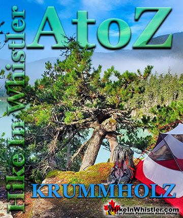
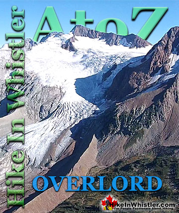
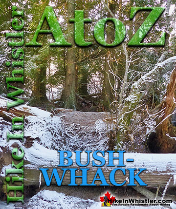
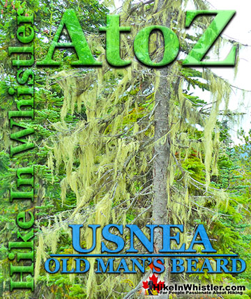
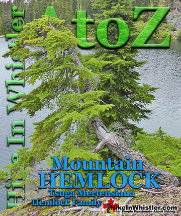
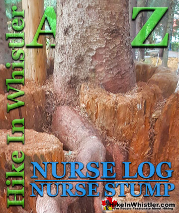
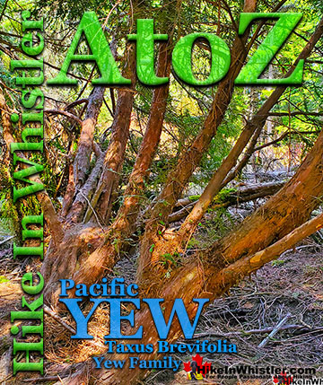
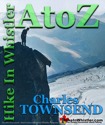
Whistler & Garibaldi Park Best Hiking by Month!


Explore BC Hiking Destinations!

Whistler Hiking Trails

Squamish Hiking Trails

Vancouver Hiking Trails

Clayoquot Hiking Trails
Victoria Hiking Trails

