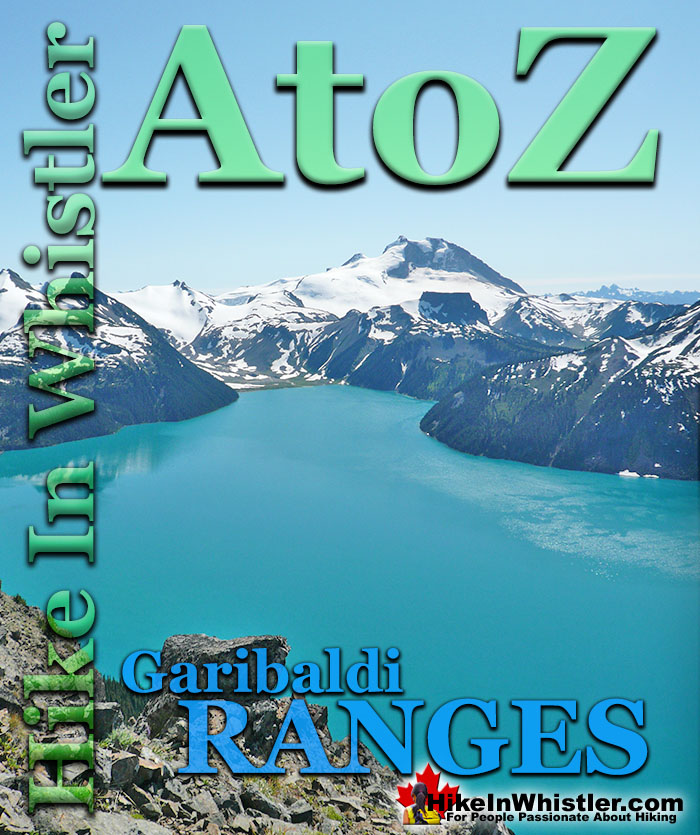
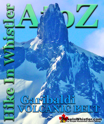
![]() The Garibaldi Ranges are a subdivision of the Pacific Ranges of the Coast Mountains. Deriving its name from Mount Garibaldi, the Garibaldi Ranges cover the huge stretch of mountains between two enormous river valleys. The Lillooet River valley on the east side and the Cheakamus River/Green River valley on the west. Whistler is located on the west edge of the Garibaldi Ranges, while Pemberton near the north end and Vancouver at the south end.
The Garibaldi Ranges are a subdivision of the Pacific Ranges of the Coast Mountains. Deriving its name from Mount Garibaldi, the Garibaldi Ranges cover the huge stretch of mountains between two enormous river valleys. The Lillooet River valley on the east side and the Cheakamus River/Green River valley on the west. Whistler is located on the west edge of the Garibaldi Ranges, while Pemberton near the north end and Vancouver at the south end.
Whistler & Garibaldi Hiking
![]() Alexander Falls
Alexander Falls ![]() Ancient Cedars
Ancient Cedars ![]() Black Tusk
Black Tusk ![]() Blackcomb Mountain
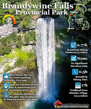
Blackcomb Mountain ![]() Brandywine Falls
Brandywine Falls ![]() Brandywine Meadows
Brandywine Meadows ![]() Brew Lake
Brew Lake ![]() Callaghan Lake
Callaghan Lake ![]() Cheakamus Lake
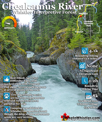
Cheakamus Lake ![]() Cheakamus River
Cheakamus River ![]() Cirque Lake
Cirque Lake ![]() Flank Trail
Flank Trail ![]() Garibaldi Lake
Garibaldi Lake ![]() Garibaldi Park
Garibaldi Park ![]() Helm Creek
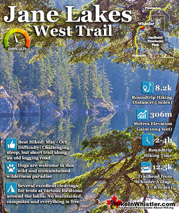
Helm Creek ![]() Jane Lakes
Jane Lakes ![]() Joffre Lakes
Joffre Lakes ![]() Keyhole Hot Springs
Keyhole Hot Springs ![]() Logger’s Lake
Logger’s Lake ![]() Madeley Lake
Madeley Lake ![]() Meager Hot Springs
Meager Hot Springs ![]() Nairn Falls
Nairn Falls ![]() Newt Lake
Newt Lake ![]() Panorama Ridge
Panorama Ridge ![]() Parkhurst Ghost Town
Parkhurst Ghost Town ![]() Rainbow Falls
Rainbow Falls ![]() Rainbow Lake
Rainbow Lake ![]() Ring Lake
Ring Lake ![]() Russet Lake
Russet Lake ![]() Sea to Sky Trail
Sea to Sky Trail ![]() Skookumchuck Hot Springs
Skookumchuck Hot Springs ![]() Sloquet Hot Springs
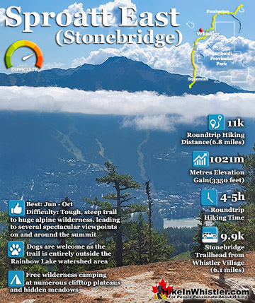
Sloquet Hot Springs ![]() Sproatt East
Sproatt East ![]() Sproatt West
Sproatt West ![]() Taylor Meadows
Taylor Meadows ![]() Train Wreck
Train Wreck ![]() Wedgemount Lake
Wedgemount Lake ![]() Whistler Mountain
Whistler Mountain
Hiking by Month
![]() January
January ![]() February
February ![]() March
March ![]() April
April ![]() May
May ![]() June
June ![]() July
July ![]() August
August ![]() September
September ![]() October
October ![]() November
November ![]() December
December
The subdivisions of the Garibaldi Ranges include Garibaldi Névé, Fitzsimmons Range, McBride Range, Spearhead Range, Golden Ears, Misty Icefield and the Bastion Range. The Fitzsimmons Range is a subsection of the Garibaldi Ranges that covers the area between the valleys of Cheakamus Lake and Fitzsimmons Creek. Fitzsimmons Creek cuts between Whistler Mountain and Blackcomb Mountain and largely originates from the Fitzsimmons Glacier. The Fitzsimmons Glacier and Mount Fitzsimmons are part of the Overlord Massif, which gets its name from the highest peak in the area, Overlord Mountain. Massif is a term used in geology to refer to a compact group of connected mountains that easily identify into one large mountain mass. Massif is a French word that means “massive”.
Overlord Mountain in Fitzsimmons Range

Fitzsimmons Range(subsection of Garibaldi Ranges)
The Fitzsimmons Range includes several locally famous summits, including the summit of Whistler, Oboe Summit, Piccolo Summit and Flute Summit. These form the Musical Bumps trail which is a gorgeous route to the Russet Lake campground in Garibaldi Provincial Park. Next to Russet Lake is The Fissile, and next to The Fissile is Overlord Mountain. Near Russet Lake and connecting to the Musical Bumps trail is the Singing Pass trail that ascends along Fitzsimmons Creek to Whistler Village at the base of Whistler Mountain.
Whistler Mountain in Fitzsimmons Range


Spearhead Range(subsection of Garibaldi Ranges)
The Spearhead Range is a subsection of the Garibaldi Ranges that runs in an arc that connects Whistler Mountain and Blackcomb Mountain. The Spearhead Range is effectively the brother of the Fitzsimmons Range which runs east from the summit of Whistler Mountain to Russet Lake. The Spearhead Range covers the area on the north side or Blackcomb Mountain side of Fitzsimmons Creek. Fitzsimmons Creek runs down the valley between Whistler Mountain and Blackcomb Mountain. Where the Fitzsimmons Range ends at Fitzsimmons Creek, the Spearhead Range begins and continues along a set of peaks resembling spearheads to Blackcomb Mountain. These peaks include The Spearhead, Mount Trorey, Tremor, Shatter, Shudder, Quiver, and more.
Blackcomb Mountain View of Overlord Glacier

Whistler Peak View of Blackcomb Mountain


McBride Range(subsection of Garibaldi Ranges)
The McBride Range is a subsection of the Garibaldi Ranges and covers a 357 square kilometre area east of Cheakamus Lake and Garibaldi Lake. Where the Spearhead Range ends, the McBride Range begins. Owing to its central location in the middle of Garibaldi Provincial Park, the McBride Range is often referred to as the backbone of Garibaldi Park. The McBride Range is a morass of brutally steep mountains and glacier valleys that expert skiers have plotted a route through. The McBride Traverse is an astoundingly difficult and beautiful, week long route through the McBride Range. Along the route you encounter several monster mountains with wonderful names, including Decker Mountain, Mount Patterson, Tremor Mountain, Sir Richard Mountain, The Gatekeeper, Forger Peaks, Isosceles Peak, Mount Carr, The Bookworms and The Sphinx.
Garibaldi Névé(subsection of Garibaldi Ranges)
The Garibaldi Névé is the large icefield that stretches out along the east side of Mount Garibaldi. With a size of 35 square kilometers(14 square miles), the Garibaldi Neve is a subdivision of the Garibaldi Ranges, which in turn is a subdivision of the Pacific Ranges of the Coast Mountains. The Garibaldi Névé Traverse is a tremendously beautiful and very treacherous winter skiing route that runs between Elfin Lakes and Garibaldi Lake. It is generally done as a three day expedition beginning and ending at two BC Parks Garibaldi Provincial Park trailheads. The Diamond Head(Garibaldi) trailhead in Squamish and the Rubble Creek, Black Tusk(Garibaldi) trailhead halfway between Squamish and Whistler. A common itinerary is the Diamond Head(Garibaldi) trailhead to Elfin Lakes on the first day. Sleeping in the very nice and well equipped Elfin Lakes hut. The second day covers the difficult Garibaldi Névé which runs from the Opal Cone north of Elfin Lakes to the foot of Sentinel Glacier northeast of The Table. The second night is usually spent at the Burton Hut at the east end of Garibaldi Lake. The third day involves crossing the length of Garibaldi Lake to the Garibaldi Lake campground and then the comparatively easy descent to Rubble Creek. The south to north route is favoured over the north south route because of the net elevation loss and much prized north facing ski descents.
Guides to the Best of Whistler
 Best Dog Friendly Hiking Trails
Whistler is very dog friendly and the number of wonderful hiking trails that your dog will love is huge. The massively varied hiking trails range from easy, short, close to Whistler Village to challenging, long and deep in the endless wilderness around Whistler. You can find dog friendly trails in and around Whistler Village that take you through deep, dark and magical forests. Or you can drive beyond Whistler Village and take your dog to spectacular alpine lakes. Some requiring little or no hiking, while others are found after hiking challenging and long trails. Many of these places are comparatively quiet and often you and your dog will have the the wilderness to yourselves. In and around Whistler Village you have Lost Lake with its spider web of trails... Continued here.
 Best Free Whistler Camping
Whistler is surrounded by an immense wilderness dotted with spectacular, hidden lakes and amazing places to set up a tent. Decades of logging activity has left a network of forest service roads that has opened easy access to these places. Some of these you can drive to and some you may need a 4x4 to comfortably get to. Some places to camp for free you can drive to, some require a short hike and others are fairly long hikes to reach. Beautiful Callaghan Valley is home to several incredible and free places to camp. Callaghan Lake has a great free drive-to campsite just steps from this spectacular alpine lake. If you have a canoe, you can paddle to the end of Callaghan Lake and hike the short, but steep trail up to Cirque Lake. This gorgeous lake is deep in the alpine wilderness... Continued here.
 No Car? No Problem! Whistler Trails
Whistler as a resort has a wonderful car-free core. The Village Stroll runs through the heart of Whistler Village and is entirely car free. If you are visiting Whistler or living here and you don't have a car, it's no problem. On foot or on a bike you can travel the extensive network of non-motorized trails. The Valley Trail snakes through Whistler Village and extends in several directions, all of which lead to beautiful parts of Whistler. The Sea to Sky Trail and the Lost Lake trails continue this massive, car-free network of trails running almost everywhere in Whistler. When it comes to many of the best hiking trails, getting to the trailheads on foot, by bike or public transit can be tricky at best or complicated and impractical at worst. Many trailheads are far from Whistler Village and... Continued here.
 Kid Friendly Whistler Hiking Trails
There are plenty of excellent, kid and family friendly hiking trails and destinations in and around Whistler. Kid and family friendly generally means an easy and somewhat short trail that a toddler can happily manage. Some of these trails are flat enough to be stroller friendly, such as Brandywine Falls, Whistler Mountain and Blackcomb Mountain. Others such as Logger’s Lake, Cheakamus River and Madeley Lake have short enough trails to reach them that you can manage with little kids that don't want to hike too far. Some of these hikes and walks are popular and close to Whistler Village, like Whistler Mountain, Blackcomb Mountain, Lost Lake Park, Rainbow Park and Meadow Park. Others are a beautiful, but far drive into the mountains and tricky to find... Continued here.
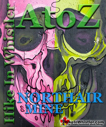
 Northair Mine Murals
Way up in the Callaghan Valley on the back side of Mount Sproatt is an abandoned gold mine. Old cement foundations and two unexpectedly beautiful lakes mark the location of Northair Mine, abandoned in 1982. It was a fairly productive gold mine that extracted five tons of gold. Largely forgotten for years, in the last decade it has come to life in stunning colour by graffiti artists and professional muralists. In the summer of 2013, the first mural appeared on the blank foundation walls of Northair Mine. A creation of a professional Whistler artist PETKO. Painted on one of the inside, pillar walls, the mural is about 8 feet tall and five feet wide of what looks like a robot snake in front of a cube background. It stood out in striking contrast to the grey walls in the background... Continued here.
 Neal Carter Mountaineer
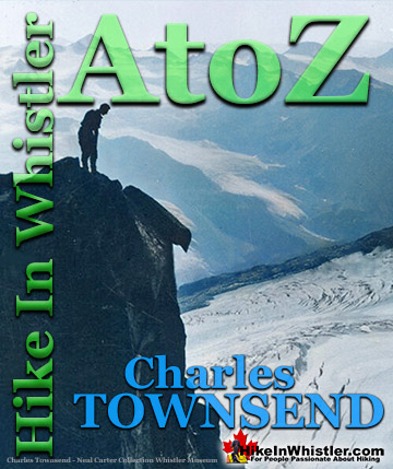
Neal Carter (14 Dec 1902 – 15 Mar 1978) was a mountaineer and early explorer of the Coast Mountains primarily in the 1920’s and 1930’s. Highly skilled as a mountaineer and climber, Carter also excelled at cartography and surveying which he used to map the vast unnamed and unexplored mountains of BC. He named a staggering number of mountains and alpine features, as well as making at least 25 first ascents, many around what we now call the Whistler Valley. Carter began climbing the mountains around Vancouver as a teenager and at the age of seventeen he met someone who would change his life forever. In 1920, while hiking with high school friends Carter had a chance encounter with Tom Fyles, arguably the greatest mountaineer of the era. Continued here.
 Tom Fyles Mountaineer
Tom Fyles (27 June 1887 - 27 March 1979) was an astoundingly skilled climber that figured prominently in the mountaineering community in Vancouver for more than two decades. From his introduction to mountaineering in 1912, to his prolific array of elite level climbing ascents that began in earnest just four years later. In 1916 he solo climbed The Table in Garibaldi Park, a mountain widely considered to be too difficult and dangerous to even attempt. Those that knew him well admired his friendliness, enthusiasm, boundless endurance and incredible ability to read a mountain and navigate the best route to the summit. He made many first ascents and inspired countless new climbers, some becoming giants of the era. Continued here.
More Whistler & Garibaldi Park Hiking A to Z!

The Best Whistler & Garibaldi Park Hiking Trails!
Whistler & Garibaldi Park Best Hiking by Month!


Explore BC Hiking Destinations!

Whistler Hiking Trails

Squamish Hiking Trails

Vancouver Hiking Trails

Clayoquot Hiking Trails
Victoria Hiking Trails

