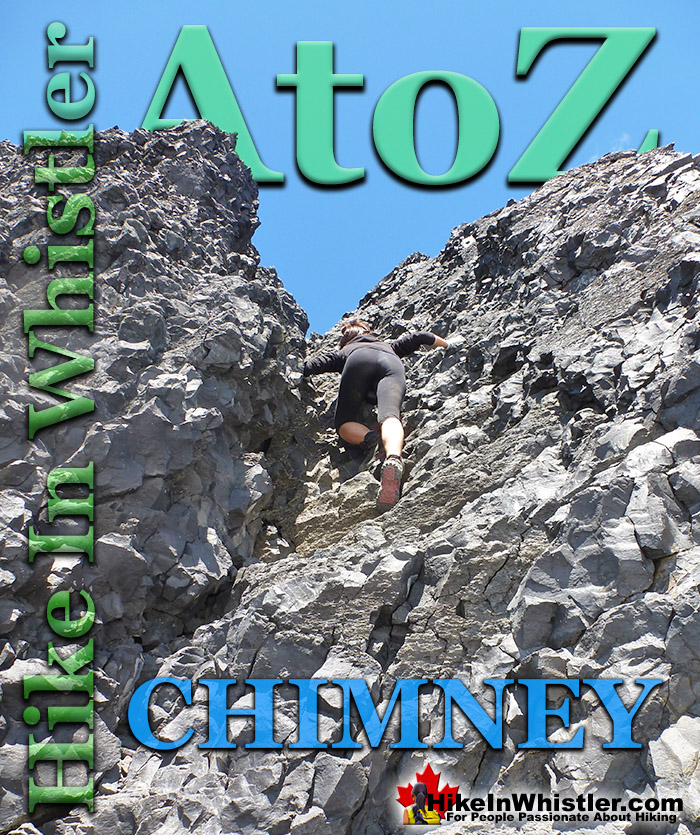
![]() Chimney: a gap between two vertical faces of rock or ice. Often a chimney offers the only viable route to the summit of a mountain. An example of this is Black Tusk in Garibaldi Provincial Park in Whistler. The final ascent of Black Tusk requires climbing a near vertical chimney with crumbling rock all around. Black Tusk is the extraordinarily iconic and appropriately named mountain that can be seen from almost everywhere in Whistler.
Chimney: a gap between two vertical faces of rock or ice. Often a chimney offers the only viable route to the summit of a mountain. An example of this is Black Tusk in Garibaldi Provincial Park in Whistler. The final ascent of Black Tusk requires climbing a near vertical chimney with crumbling rock all around. Black Tusk is the extraordinarily iconic and appropriately named mountain that can be seen from almost everywhere in Whistler.
Whistler & Garibaldi Hiking
![]() Alexander Falls
Alexander Falls ![]() Ancient Cedars
Ancient Cedars ![]() Black Tusk
Black Tusk ![]() Blackcomb Mountain
Blackcomb Mountain ![]() Brandywine Falls
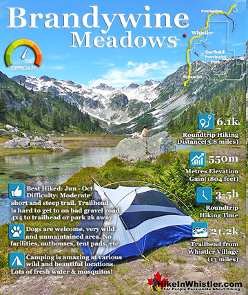
Brandywine Falls ![]() Brandywine Meadows
Brandywine Meadows ![]() Brew Lake
Brew Lake ![]() Callaghan Lake
Callaghan Lake ![]() Cheakamus Lake
Cheakamus Lake ![]() Cheakamus River
Cheakamus River ![]() Cirque Lake
Cirque Lake ![]() Flank Trail
Flank Trail ![]() Garibaldi Lake
Garibaldi Lake ![]() Garibaldi Park
Garibaldi Park ![]() Helm Creek
Helm Creek ![]() Jane Lakes
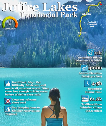
Jane Lakes ![]() Joffre Lakes
Joffre Lakes ![]() Keyhole Hot Springs
Keyhole Hot Springs ![]() Logger’s Lake
Logger’s Lake ![]() Madeley Lake
Madeley Lake ![]() Meager Hot Springs
Meager Hot Springs ![]() Nairn Falls
Nairn Falls ![]() Newt Lake
Newt Lake ![]() Panorama Ridge
Panorama Ridge ![]() Parkhurst Ghost Town
Parkhurst Ghost Town ![]() Rainbow Falls
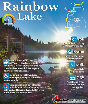
Rainbow Falls ![]() Rainbow Lake
Rainbow Lake ![]() Ring Lake
Ring Lake ![]() Russet Lake
Russet Lake ![]() Sea to Sky Trail
Sea to Sky Trail ![]() Skookumchuck Hot Springs
Skookumchuck Hot Springs ![]() Sloquet Hot Springs
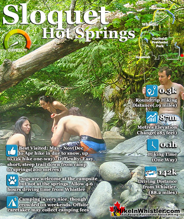
Sloquet Hot Springs ![]() Sproatt East
Sproatt East ![]() Sproatt West
Sproatt West ![]() Taylor Meadows
Taylor Meadows ![]() Train Wreck
Train Wreck ![]() Wedgemount Lake
Wedgemount Lake ![]() Whistler Mountain
Whistler Mountain
![]() January
January ![]() February
February ![]() March
March ![]() April
April ![]() May
May ![]() June
June ![]() July
July ![]() August
August ![]() September
September ![]() October
October ![]() November
November ![]() December
December
The massive black spire of crumbling rock juts out of the earth in an incredibly distinct way that appears like an enormous black tusk plunging out of the ground. Whether you spot it in the distance from the top of Whistler Mountain or from dozens of vantage points along the Sea to Sky Highway, its unmistakable appearance is breathtaking. The image below is a view of hikers climbing down the Black Tusk chimney. Whether you see it from the highway or from closer vantage points such as Taylor Meadows, Helm Creek, Panorama Ridge or Garibaldi Lake, all views make climbing to the top look impossible. In fact, Black Tusk seems to look more impossible to climb the closer you get to it. Even when you are close enough to touch its vertical, black and crumbling sides, you wonder in amazement how anyone can ever reach the top. Black Tusk is within the Garibaldi Volcanic Belt also called the Canadian Cascade Arc. This volcanic belt contains mostly dormant volcanoes, though also includes the much alive and infamous Mount St. Helens in Washington State, in the US. Mount Garibaldi from which Garibaldi Park gets its name was an active volcano as recently as 9300 years ago. Also in the area but well north of Black Tusk near Pemberton, Mount Meager had multiple eruptions ending only recently, that is 2350 years ago according to recent studies. Meager now has become known in the region for its alarmingly frequent mudslides that terrorize the Meager Hot Springs below and the town of Pemberton further down the valley. The last mudslide occurred just a couple years ago and was one of the largest in recorded Canadian history. Pemberton was partly evacuated as a result.


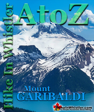
The image below is looking out from near the top of the Black Tusk chimney. Panorama Ridge extends to the left, then Garibaldi Lake, The Table and Mount Garibaldi is the giant in the distance. About 170,000 years ago renewed volcanic activity in what is now Garibaldi Park produced a lava dome within a cinder-rich volcanic cone itself over a million years old. Cinder-rich simply means that the cone formed out of explosive volcanic action and hardened, to some extent, in the air and therefore filled with air pockets and evidently light and weak in structure. This lava dome which was to become Black Tusk, hardened inside this more easily eroded cinder cone, so in the past 170,000 years the outer cinder cone has crumbled away to reveal the lava dome within. The Black Tusk itself is extremely crumbly as well as can be seen when you near it. It looks as if erupting out of a uniformly sloping mountain of jagged, black boulders.


More Whistler & Garibaldi Park Hiking A to Z!

The Best Whistler & Garibaldi Park Hiking Trails!
Whistler & Garibaldi Park Best Hiking by Month!


Explore BC Hiking Destinations!

Whistler Hiking Trails

Squamish Hiking Trails

Vancouver Hiking Trails

Clayoquot Hiking Trails
Victoria Hiking Trails

