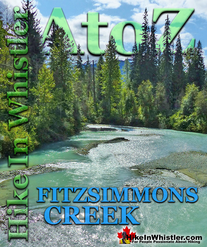
![]() Fitzsimmons Creek is the beautiful and huge creek that crashes through Whistler Village. When walking from Whistler Village to the Upper Village, you will cross the nice, covered bridge over Fitzsimmons Creek. It passes through Whistler Village and pours into Green Lake at the north end of Whistler. Fitzsimmons Creek originates from Overlord Glacier and Russet Lake, about 12 kilometres up the valley that separates Whistler Mountain and Blackcomb Mountain.
Fitzsimmons Creek is the beautiful and huge creek that crashes through Whistler Village. When walking from Whistler Village to the Upper Village, you will cross the nice, covered bridge over Fitzsimmons Creek. It passes through Whistler Village and pours into Green Lake at the north end of Whistler. Fitzsimmons Creek originates from Overlord Glacier and Russet Lake, about 12 kilometres up the valley that separates Whistler Mountain and Blackcomb Mountain.
Whistler & Garibaldi Hiking
![]() Alexander Falls
Alexander Falls ![]() Ancient Cedars
Ancient Cedars ![]() Black Tusk
Black Tusk ![]() Blackcomb Mountain
Blackcomb Mountain ![]() Brandywine Falls
Brandywine Falls ![]() Brandywine Meadows
Brandywine Meadows ![]() Brew Lake
Brew Lake ![]() Callaghan Lake
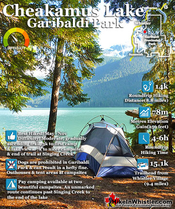
Callaghan Lake ![]() Cheakamus Lake
Cheakamus Lake ![]() Cheakamus River
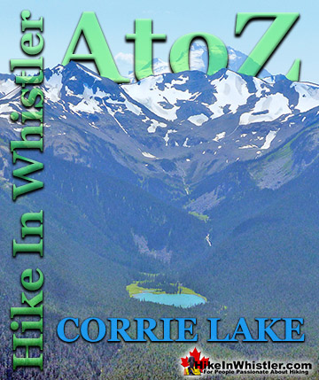
Cheakamus River ![]() Cirque Lake
Cirque Lake ![]() Flank Trail
Flank Trail ![]() Garibaldi Lake
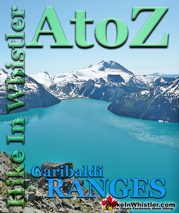
Garibaldi Lake ![]() Garibaldi Park
Garibaldi Park ![]() Helm Creek
Helm Creek ![]() Jane Lakes
Jane Lakes ![]() Joffre Lakes
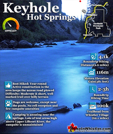
Joffre Lakes ![]() Keyhole Hot Springs
Keyhole Hot Springs ![]() Logger’s Lake
Logger’s Lake ![]() Madeley Lake
Madeley Lake ![]() Meager Hot Springs
Meager Hot Springs ![]() Nairn Falls
Nairn Falls ![]() Newt Lake
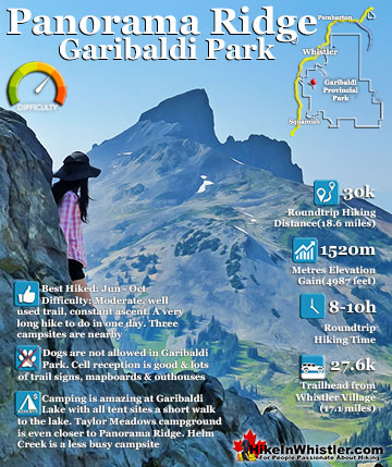
Newt Lake ![]() Panorama Ridge
Panorama Ridge ![]() Parkhurst Ghost Town
Parkhurst Ghost Town ![]() Rainbow Falls
Rainbow Falls ![]() Rainbow Lake
Rainbow Lake ![]() Ring Lake
Ring Lake ![]() Russet Lake
Russet Lake ![]() Sea to Sky Trail
Sea to Sky Trail ![]() Skookumchuck Hot Springs
Skookumchuck Hot Springs ![]() Sloquet Hot Springs
Sloquet Hot Springs ![]() Sproatt East
Sproatt East ![]() Sproatt West
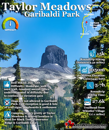
Sproatt West ![]() Taylor Meadows
Taylor Meadows ![]() Train Wreck
Train Wreck ![]() Wedgemount Lake
Wedgemount Lake ![]() Whistler Mountain
Whistler Mountain
![]() January
January ![]() February
February ![]() March
March ![]() April
April ![]() May
May ![]() June
June ![]() July
July ![]() August
August ![]() September
September ![]() October
October ![]() November
November ![]() December
December
The Singing Pass trail, one of Garibaldi Park's main access trailheads, runs parallel to Fitzsimmons Creek up to the alpine leading to Russet Lake, The Fissile, Overlord Glacier, Overlord Mountain, Musical Bumps, Whistler Mountain, and quite a lot more. Fitzsimmons Creek, along with Mount Fitzsimmons and Fitzsimmons Glacier are named after Jimmy Fitzsimmons, a miner that worked the area a century ago. Jimmy Fitzsimmons had a little cabin near the head of Fitzsimmons Creek in the meadow just before the the Singing Pass trail now splits left to Russet Lake or right to the Musical Bumps trail. The cabin was used by Neal Carter and Charles Townsend during their famous mountaineering expedition in the area in 1923. There are lots of beautiful places to see Fitzsimmons River along its 15 kilometre length. Fitzsimmons Fan Park is a cute little park on Green Lake where Fitzsimmons Creek flows into the lake. Fine glacial till has settled here and created a large, fan-shaped sandy beach that juts out into Green Lake. Even on the hottest, sunniest August days here Fitzsimmons Creek is still bitterly cold, glacier water. Trails and forest run along most of the length of Fitzsimmons Creek as it winds through Whistler Village, but for most visitors to Whistler, the first time they see it is from the Peak 2 Peak Gondola.
The Peak 2 Peak Gondola crosses Fitzsimmons Creek at a staggering height of 436 metres(1430 feet). Looking down you can trace the route Fitzsimmons Creek takes up the valley to its source, Overlord Mountain. Shown here is Overlord Glacier on the north face of Overlord Mountain. The Fissile is the prominent peak on the right. The Fissile is visible from many places in Whistler, including on Village Gate Boulevard which was designed to face this stunning mountain.

Russet Lake shown below is another source for Fitzsimmons Creek. This cute lake fills the valley below The Fissile. Russet Lake flows down the valley via Russet Creek before merging into Fitzsimmons Creek. Russet Lake is one of the main campgrounds for Garibaldi Provincial Park and accessible via the Singing Pass trail from Whistler Village or the Musical Bumps and/or High Note trail from Whistler Mountain.


Adit Lakes, shown here below, is another source of Fitzsimmons Creek. Hidden just north of Russet Lake, up on the other side of a bench these two cute little tarns flow down to Russet Creek, then connect to Fitzsimmons Creek. Adit Lakes have a pretty spectacular view across the valley. The two prominent peaks in the image below are Tremor Mountain and Mount Macbeth. The lower glacier is Curtain Glacier and the upper one is Platform Glacier. Fitzsimmons Glacier is hidden in the valley below Mount Macbeth in the far right of the picture. All of these glaciers and lakes feed into Fitzsimmons Creek and flow down the valley to Green Lake. Green Lake gets its remarkable emerald green colour from these glaciers. Fine particles of glacial till suspended in the water reflect light and give Green Lake its beautiful colour.

The two images below are taken from the Peak 2 Peak Gondola 436 metres above Fitzsimmons Creek. The building visible in the lower picture is the hydroelectric dam that provides power to most of Whistler's mountain operations. The Singing Pass trail runs roughly parallel to the right of Fitzsimmons Creek up the valley to Russet Lake. Jimmy Fitzsimmons original trail actually ran up the left side of Fitzsimmons Creek and crossed approximately where this building is now and continued up the right side of the creek to his cabin. The Singing Pass trail is entirely on the right side of the creek because a dirt road was made up the Whistler side of the creek and a trailhead parking area was installed. The original Singing Pass, Garibaldi Provincial Park trailhead was actually of to the right of the hydro building. A landslide wiped out a section of the road a few decades ago and was not fixed, so the trailhead is effectively in Whistler Village! Eventually the old bridge crossing used by Jimmy Fitzsimmons will be rebuilt and the Singing Pass trailhead will be located near the hydroelectric building.


There are many great places to see Fitzsimmons Creek in and around Whistler Village. The bridge crossing to Upper Village mentioned above is good. Next to the bridge is Rebagliati Park, which runs along the edge of the creek and into a nice forest that continues through to the skate park. Nice paths run through the forest and frequently open up to great little access points to Fitzsimmons Creek. Continuing further past the skate park you can follow the Valley Trail as it runs parallel to the creek and passes under Lorimer Road. The trail then branches in a few directions, Valley Trail to Lost Lake, Valley Trail along Lorimer Road and the Fitzsimmons Trail. The Fitzsimmons Trail runs through a nice old forest along Fitzsimmons Creek. Along here you have plenty of fantastic places along the river to see. The Fitzsimmons Trail come out under Nancy Green Drive and you can continue along the river via the Valley Trail for another couple kilomtres until you pass through Riverside Campground and emerge at their gravel parking lot between Fitszimmons Creek and Old Mill Road. You can then continue down Old Mill Road where it merges with the Valley Trail and crosses Fitzsimmons Creek and into the vast network of Lost Lake trails. The map shown below is a 9 kilometre circle route that takes you along Fitzsimmons Creek and returns via Lost Lake.


More Whistler & Garibaldi Park Hiking A to Z!

The Best Whistler & Garibaldi Park Hiking Trails!
Whistler & Garibaldi Park Best Hiking by Month!


Explore BC Hiking Destinations!

Whistler Hiking Trails

Squamish Hiking Trails

Vancouver Hiking Trails

Clayoquot Hiking Trails
Victoria Hiking Trails

