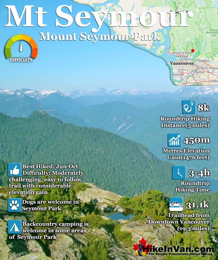
The busy Mount Seymour trail in Seymour Provincial Park is a locals favourite. It is challenging and an excellent workout at 4 kilometres from the trailhead to the summit. The views are phenomenal. On a clear day you can see as far as Vancouver Island as well as amazing views of Vancouver, the lower mainland and the Gulf Islands. Located in the beautiful Mount Seymour Provincial Park there are several hikes in the area.
There are a few easy lake trails like Mystery Lake and Goldie Lake. These are family friendly hikes. Another, relatively easy hike branches off shortly after the start of the trail to Mount Seymour. Dog Mountain, easy and also family friendly and very popular in the winter as a snowshoeing trail.
Mount Elsay is another hike in the area. Very difficult, the Mount Elsay Trail branches off of the Mount Seymour Trail just as you approach Mount Seymour and takes you into some difficult, wilderness hiking. Mount Seymour Provincial Park is very dog friendly and backcountry camping is welcome in several areas. Usually beyond Mount Seymour in the Elsay Lake part of the park.
The trailhead for Mount Seymour is easy to find once you have reached the main parking lot to Mount Seymour Resort. To get to the main parking lot simply drive until you come to the end of the road and the end of the final parking lot (you will see ski lifts). Looking towards the end of this long parking lot you will see a large, round wooden map board (indicated on the map below by the red marker). From here on there are frequent tree markers and signs directing you.
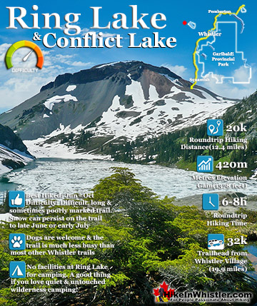
Ring Lake is a fantastically serene and wonderfully remote lake similar to Cirque Lake, but considerably farther to hike to reach it. The 10 kilometre(6.2 mile) hike takes you through a rarely hiked forest, ...
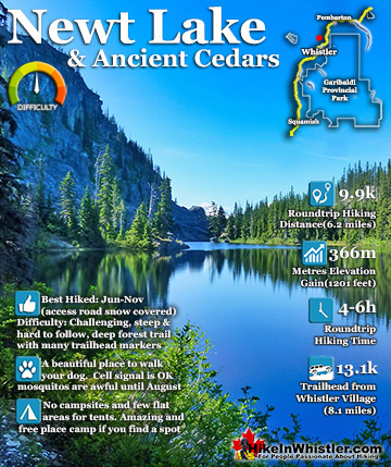
Newt Lake is cute little hidden lake high up on the far side of Cougar Mountain near Ancient Cedars. Its location is a wonderful mix of unexpected characteristics that combine to make it a gorgeous place to ...
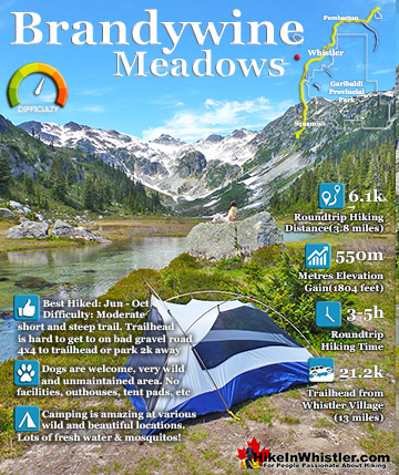
Brandywine Meadows is a nice, relatively short hike to a massive flower filled valley high up in Callaghan Valley. Located 40 minutes south of Whistler, this tough and sometimes muddy trail gains a huge 550 ...
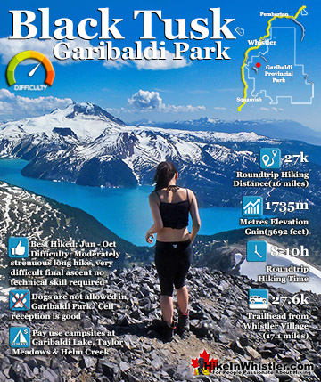
Black Tusk is the extraordinarily iconic and appropriately named mountain that can be seen from almost everywhere in Whistler. The massive black spire of crumbling rock juts out of the earth in an incredibly ...
Hiking in Whistler in October is often unexpectedly stunning. The days are much shorter and colder but the mountains are alive with colour from the fall ...
November in Whistler is when the temperatures plummet and the first heavy snow falls in the alpine and often in Whistler Village. The hiking opportunities become ...
December hiking in Whistler is mainly done on snowshoes, though not always. If it hasn't snowed much recently then trails such as Whistler Train Wreck and ...
Hiking in Whistler is spectacular and wonderfully varied. Looking at a map of Whistler you see an extraordinary spider web of hiking trails that are unbelievably numerous. Easy trails, moderate trails and challenging hiking trails are all available. Another marvellous ...
Squamish is located in the midst of a staggering array of amazing hiking trails. Garibaldi Provincial Park sprawls alongside Squamish and up and beyond Whistler. Tantalus Provincial Park lays across the valley to the west and the wonderfully remote Callaghan Valley ...
Clayoquot Sound has a staggering array of hiking trails within it. Between Tofino and Ucluelet, Pacific Rim Park has several wilderness and beach trails, each one radically different from the last. The islands in the area are often Provincial parks on their own with ...
Victoria has a seemingly endless number of amazing hiking trails. Most take you to wild and beautiful Pacific Ocean views and others take you to tranquil lakes in beautiful BC Coastal Rainforest wilderness. Regional Parks and Provincial Parks are everywhere you turn in ...
The West Coast Trail was created after decades of brutal and costly shipwrecks occurred along the West Coast of Vancouver Island. One shipwreck in particular was so horrific, tragic and unbelievable that it forced the creation of a trail along the coast, which ...
 Sensational views at the peaks
 Tougher hike than most expect