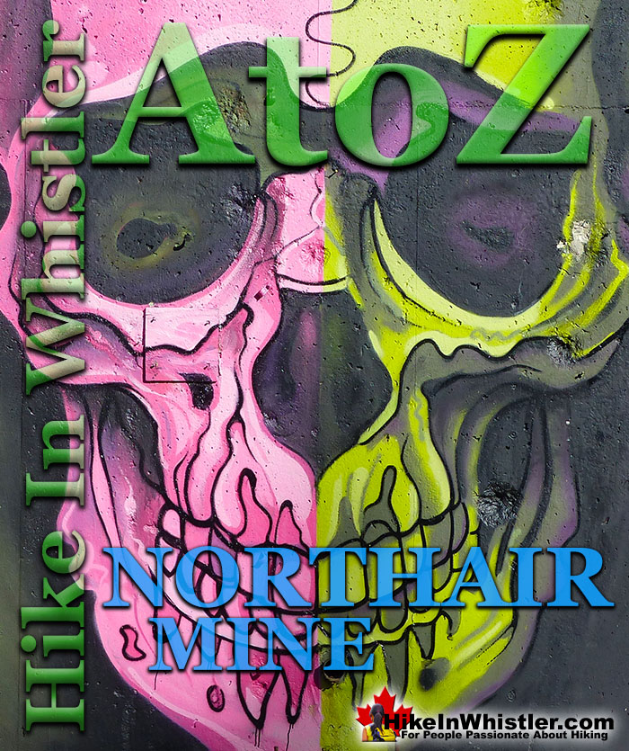
![]() Northair Mine is wonderful, hidden world high up in Callaghan Valley. It was a gold mine run by the Northair Group from 1976 until was abandoned in 1982 due to waning profitability and slumping gold prices. The buildings and construction equipment were removed, leaving only the cement foundations and a scattering of metal cables. For decades the foundations and surrounding area remained untouched except for the occasional visitor to the old ruins or the nice lake beside it.
Northair Mine is wonderful, hidden world high up in Callaghan Valley. It was a gold mine run by the Northair Group from 1976 until was abandoned in 1982 due to waning profitability and slumping gold prices. The buildings and construction equipment were removed, leaving only the cement foundations and a scattering of metal cables. For decades the foundations and surrounding area remained untouched except for the occasional visitor to the old ruins or the nice lake beside it.
Whistler & Garibaldi Hiking
![]() Alexander Falls
Alexander Falls ![]() Ancient Cedars
Ancient Cedars ![]() Black Tusk
Black Tusk ![]() Blackcomb Mountain
Blackcomb Mountain ![]() Brandywine Falls
Brandywine Falls ![]() Brandywine Meadows
Brandywine Meadows ![]() Brew Lake
Brew Lake ![]() Callaghan Lake
Callaghan Lake ![]() Cheakamus Lake
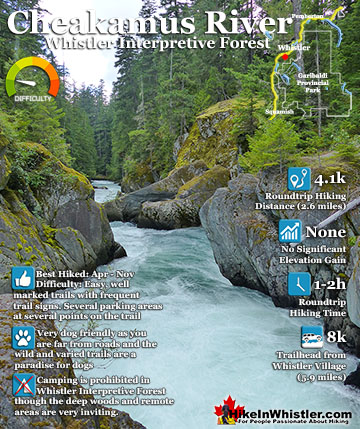
Cheakamus Lake ![]() Cheakamus River
Cheakamus River ![]() Cirque Lake
Cirque Lake ![]() Flank Trail
Flank Trail ![]() Garibaldi Lake
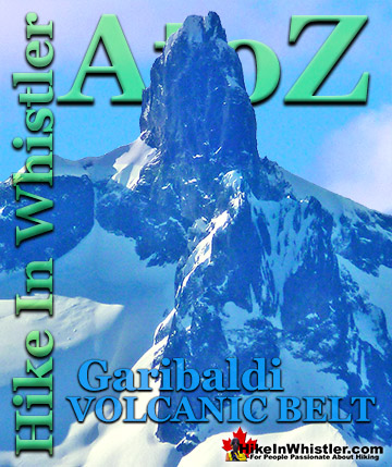
Garibaldi Lake ![]() Garibaldi Park
Garibaldi Park ![]() Helm Creek
Helm Creek ![]() Jane Lakes
Jane Lakes ![]() Joffre Lakes
Joffre Lakes ![]() Keyhole Hot Springs
Keyhole Hot Springs ![]() Logger’s Lake
Logger’s Lake ![]() Madeley Lake
Madeley Lake ![]() Meager Hot Springs
Meager Hot Springs ![]() Nairn Falls
Nairn Falls ![]() Newt Lake
Newt Lake ![]() Panorama Ridge
Panorama Ridge ![]() Parkhurst Ghost Town
Parkhurst Ghost Town ![]() Rainbow Falls
Rainbow Falls ![]() Rainbow Lake
Rainbow Lake ![]() Ring Lake
Ring Lake ![]() Russet Lake
Russet Lake ![]() Sea to Sky Trail
Sea to Sky Trail ![]() Skookumchuck Hot Springs
Skookumchuck Hot Springs ![]() Sloquet Hot Springs
Sloquet Hot Springs ![]() Sproatt East
Sproatt East ![]() Sproatt West
Sproatt West ![]() Taylor Meadows
Taylor Meadows ![]() Train Wreck
Train Wreck ![]() Wedgemount Lake
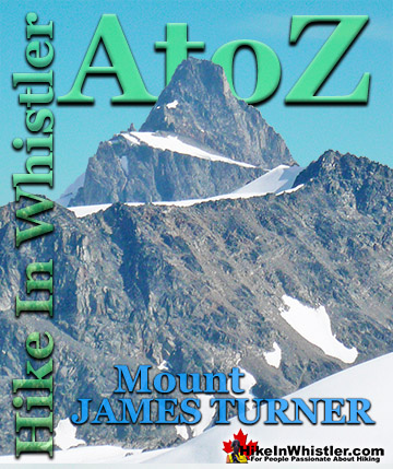
Wedgemount Lake ![]() Whistler Mountain
Whistler Mountain
![]() January
January ![]() February
February ![]() March
March ![]() April
April ![]() May
May ![]() June
June ![]() July
July ![]() August
August ![]() September
September ![]() October
October ![]() November
November ![]() December
December
In the summer of 2013, a professional Whistler artist, PETKO painted a colourful mural on one of the small, inside pillar walls. The following summer he painted two more, much larger murals. At about that time Canadian Wilderness Adventures, who do ATV tours up Mount Sproatt, built some ATV ramps and trails through Northair Mine. By 2019, nearly every wall was covered in strikingly colourful, surreal and beautiful murals done by other professional artists. Despite the appearance of activity in recent years, Northair Mine remains fairly quiet except for the occasional groups of ATV’s that trundle past. Throughout the summer you encounter little humanity up there, except weekends where you will likely see a car or two and a handful of people in the area. If you go there on an average sunny, midweek day, you often have the place to yourself. The reason for its lack of popularity is largely due to its pretty bad logging road which has decayed over the years and packed with waterbars, boulders and potholes. A regular car would have a lot of trouble getting there, if they could make it at all. There are lots of hidden wonders in the sprawling old mining site that are easily overlooked. Everybody misses the tunnel entrance to the kilometre-long network of mining tunnels bored deep into the solid rock. There are three “portals” as these are called, but the one next to the mural painted cement foundations is the only one that is sort of accessible, not to mention easy to find. Though the entrance gets routinely buried, it also gets routinely unburied. It was recently explored by two cave explorers, who managed to cover about two thirds of the tunnels on their first visit.
Northair Mine is located on the west side of the huge and sprawling Mount Sproatt. From Whistler Village it takes about an hour to drive there. The old logging road to get there continues beyond Northair Mine for a few kilometres to take you high up to the Sproatt West(Northair) trailhead to Mount Sproatt. From here you can hike into the massive and tranquil alpine wilderness which is crisscrossed with a vast spider web of hiking and biking trails. Northair Mine is often the trailhead for hiking or biking up Mount Sproatt from the west side as the access road rapidly narrows and worsens the further up you go.
Northair Mine and Callaghan Valley Map
The Callaghan Valley around Northair Mine is packed with amazing lakes, waterfalls and hidden wonders. Alexander Falls, Mount Sproatt, Madeley Lake, Callaghan Lake and Cirque Lake are all found in the spectacular Callaghan Valley.

Northair Mine Murals
A decade ago Northair Mine was a blank canvas and a bit bland compared to the ever-changing collection of beautiful murals we see today. It wasn’t until 2013 that one professional muralist, PETKO, decided to paint on one of the walls of Northair Mine. Over the next five years’ other graffiti artists and muralists added to the collection and by 2019 Northair Mine became an ever changing, and often spectacular art exhibit.

Northair Mine Turned Art Exhibit
Northair Mine was closed and abandoned in 1982 and for more than three decades, the cement foundation walls were largely untouched. In the summer of 2013, the first mural in Northair Mine appeared, a creation of a professional Whistler artist PETKO. Painted on one of the inside, pillar walls, the mural is about 8 feet tall and five feet wide of what looks like a robot snake in front of a cube background. When first painted, with its green, blue, black and white interconnecting squares, it stood out in striking contrast to the bland grey walls in the background.

In July 2013, the PETKO mural was the only one in the otherwise blank canvas ruins of Northair Mine.

Northair Mine's First Mural is Born
Northair Mine Murals 2014
In 2014 PETKO painted another, much larger robot snake mural on the south facing wall. Another large one, GET TO HIGH GROUND! was painted on the inside, south facing wall as well at that time. The original PETKO mural from 2013 is facing the other direction on the pillar in the middle, opposite the blue tarp.

Northair Mine ATV Track 2015
Canadian Wilderness Adventures installed ATV ramps and features throughout Northair Mine.

Northair Mine Graffiti 2018
Colourful graffiti covered some of the foundation walls in 2018. Notice the original PETKO mural from 2013 in the background.


Northair Mine Murals 2019
In 2019 Northair Mine really began to be consistently updated with an ever changing and staggering collection of murals and graffiti art. With the uneven array of cement foundation walls you find yourself wandering around as if looking at an art exhibit, which of course it is. The Ravens mural by Kups gave the south facing wall a beautiful aspect to it that it never had before. Northair Mine has always been a pretty surreal place, hidden up in the wilderness and the addition of beautiful and colourful murals makes it even more special.

Northair Mine Murals 2022
By 2022 the old foundation walls of Northair Mine are mostly covered in stunning murals and colourful graffiti.


History of Northair Mine
In the late 1960’s when the Callaghan Valley was a mostly untouched mountain wilderness an amateur prospector found high gold content in samples from the Brandywine area. Dr. Mike Warshawski, a Vancouver dentist and budding prospector had recently taken courses in geology and basic prospecting. Doing silt sampling from rivers and creeks, he traced the source higher and higher into Callaghan Valley to the site of what would eventually be the Northair Mine. The source he found came from a small, unnamed stream, which he named Anomaly Creek, because he found anomalous levels of minerals from it. Warshawski then contacted the head of geology at BCIT, A.H.Manifold for help. In 1970 the pair partnered up and took extensive soil samples until they zeroed in on the more precise location of the source, or more technically, the “mineralized float”.
They staked claims over the entire area and began trenching and sampling systematically. They found very promising gold and silver in an outcropping quartz vein that extended deep underground. These promising results attracted a mining company, McIntyre Mines to option the property in 1971. They investigated the potential find and decided the following year that it was not worth mining and dropped the option. That same summer, a Vancouver mining company, Northair Mines investigated with 28 exploratory holes into the vein. The results were so promising that Northair Mines picked up the option on the property in May of 1973 and plans were quickly underway for the new Northair Mine.
Production from Northair Mine began on April 26th, 1976 and just a few weeks later the first gold/silver brick was produced. The mine produced what are called mill concentrates. These concentrates are then refined off site to extract the gold and silver. Northair Mine was extracting these materials from tunnels bored into the solid rock of the west side of Mount Sproatt. There were, and still are, three tunnels, or adits into the mountain that connect deep underground and add up to over a kilometre. This tunnel network connects the two zones that run along the quartz vein and then connects down to the mill site. Effectively two offset tunnels at different levels, the highest one on the mountain, the Manifold Zone, and the Warman Zone lower down. These two then intersect with a third tunnel that descends down through the mountain to emerge at what was the Northair Mine mill site.
Today, if you are checking out the beautiful murals at Norhthair Mine, you are only about 150 metres from the mill site tunnel entrance. In fact, you may have parked your car right across from the mostly buried entrance. Never completely buried, you will know you have found it as quite a powerful, cold wind emerges from the opening. Of the three tunnel entrances, or portals as they were called when created and used by Northair Mine, only two are still visible today. The Manifold Portal and the Warman Portal are both pretty buried by rock slides, though the Manifold Portal is at least visible.
Northair Mine continued production until 1982 when declining production yields and gold prices reduced profitability. It was abandoned, and all but the cement foundations were removed, the three portals were blocked by metal gates and largely forgotten. In the 1980’s Whistler as a ski resort was exploding and the Callaghan Valley Road was still a bumpy logging road. Forestry companies moved in and harvested massive tracts of the forest around the abandoned mine. Canadian Wilderness Adventures set up shop in the area and continue running Snowmobile and ATV tours past, and in recent years, through Northair Mine. Just before the 2010 Winter Olympics came to Whistler and Vancouver, the Callaghan Valley Road was paved all the way to Whistler Olympic Park just up the road from the turnoff to Northair Mine.
Mining Tunnels at Northair Mine
The massive tunnel network at Northair Mine is largely unchanged from when it was last used in 1982. The lower tunnel, with its partly buried entrance is just steps from the graffiti and mural covered remnants of Northair Mine. Sometimes buried, sometimes unburied, it quickly opens up to quite a large tunnel, much bigger than a standard hallway in your house. It extends dead straight for hundreds of metres, slowly ascending up through the solid rock, deep into Mount Sproatt. There are countless connecting tunnels up and down with rickety ladders ascending and descending into the dark. Every few metres you pass a “Manway” extending at an angle up toward the surface. There are even abandoned ventilation fans throughout the tunnel and thick power lines, water lines and plenty more. Almost immediately after entering the tunnel you find it flooded and have to wade through thigh deep, ice cold water. This only lasts a couple hundred metres before you emerge onto solid ground.

The other two portals are buried by rock slides. Huge, flat chunks of fridge sized rock cover the Warman Portal. The Manifold Portal is only partly buried, however there are terrifying chunks of cliff fractured and held up only by the mangled gate that is now crushed beyond recognition. To get in, you would have to do some digging and hope the cliff above doesn’t come crashing down.

Getting to Northair Mine
Northair Mine is a surreal little world of colourful murals on abandoned cement foundations, beside a tranquil lake in a secluded forest. An increasingly terrible 5.4 kilometre Callaghan Creek FSR off the luxuriously paved Callaghan Valley Road takes you there in about an hour’s drive from Whistler Village. If you’ve ever been to Alexander Falls you would have driven past the unmarked turnoff which is just a minute or two before you reach the falls. From Whistler Village, zero your odometer at Village Gate Boulevard and turn south onto the Sea to Sky Highway. At 13.8 kilometres turn right onto Callaghan Valley Road. At 21.4 kilometres turn right onto Callaghan Creek FSR. In a couple kilometres the gravel road forks with one fork continuing almost straight and gradually downhill. You have to take the left fork which is about as abrupt as a U-turn and continues steadily uphill all the way to the unmarked left turn for Northair Mine at 26.8km from Whistler Village. Remember, the turnoff into Northair Mine is not obvious so keep an eye on your odometer to know when to turn left. If you measure from the turnoff from the paved Callaghan Valley Road onto the gravel Callaghan Creek FSR, the distance is 5.4km.

Guides to the Best of Whistler
 Best Dog Friendly Hiking Trails
Whistler is very dog friendly and the number of wonderful hiking trails that your dog will love is huge. The massively varied hiking trails range from easy, short, close to Whistler Village to challenging, long and deep in the endless wilderness around Whistler. You can find dog friendly trails in and around Whistler Village that take you through deep, dark and magical forests. Or you can drive beyond Whistler Village and take your dog to spectacular alpine lakes. Some requiring little or no hiking, while others are found after hiking challenging and long trails. Many of these places are comparatively quiet and often you and your dog will have the the wilderness to yourselves. In and around Whistler Village you have Lost Lake with its spider web of trails... Continued here.
 Best Free Whistler Camping
Whistler is surrounded by an immense wilderness dotted with spectacular, hidden lakes and amazing places to set up a tent. Decades of logging activity has left a network of forest service roads that has opened easy access to these places. Some of these you can drive to and some you may need a 4x4 to comfortably get to. Some places to camp for free you can drive to, some require a short hike and others are fairly long hikes to reach. Beautiful Callaghan Valley is home to several incredible and free places to camp. Callaghan Lake has a great free drive-to campsite just steps from this spectacular alpine lake. If you have a canoe, you can paddle to the end of Callaghan Lake and hike the short, but steep trail up to Cirque Lake. This gorgeous lake is deep in the alpine wilderness... Continued here.
 No Car? No Problem! Whistler Trails
Whistler as a resort has a wonderful car-free core. The Village Stroll runs through the heart of Whistler Village and is entirely car free. If you are visiting Whistler or living here and you don't have a car, it's no problem. On foot or on a bike you can travel the extensive network of non-motorized trails. The Valley Trail snakes through Whistler Village and extends in several directions, all of which lead to beautiful parts of Whistler. The Sea to Sky Trail and the Lost Lake trails continue this massive, car-free network of trails running almost everywhere in Whistler. When it comes to many of the best hiking trails, getting to the trailheads on foot, by bike or public transit can be tricky at best or complicated and impractical at worst. Many trailheads are far from Whistler Village and... Continued here.
 Kid Friendly Whistler Hiking Trails
There are plenty of excellent, kid and family friendly hiking trails and destinations in and around Whistler. Kid and family friendly generally means an easy and somewhat short trail that a toddler can happily manage. Some of these trails are flat enough to be stroller friendly, such as Brandywine Falls, Whistler Mountain and Blackcomb Mountain. Others such as Logger’s Lake, Cheakamus River and Madeley Lake have short enough trails to reach them that you can manage with little kids that don't want to hike too far. Some of these hikes and walks are popular and close to Whistler Village, like Whistler Mountain, Blackcomb Mountain, Lost Lake Park, Rainbow Park and Meadow Park. Others are a beautiful, but far drive into the mountains and tricky to find... Continued here.
 Best Sights Sea to Sky 99
The Sea to Sky Highway links Vancouver to Whistler and has several stops along the way that are often overlooked. Porteau Cove, for example, is surprisingly unknown even to locals that have driven past hundreds of times. Just off the highway the parking area is just steps from the huge pier stretching way out over the ocean. This gigantic pier is actually a rarely used emergency dock for BC Ferries, though more often used by visitors for its stunning views of Howe Sound. Porteau Cove is an excellent pit stop on the way to Whistler, not only for the spectacular views of Howe Sound, but one of the nicest picnic spots and most convenient restrooms! Other attractions along the Sea to Sky Highway are more obvious, such as Shannon Falls, the Sea to Sky Gondola... Continued here.
 Best Whistler Waterfalls
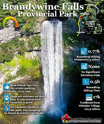
There are lots of beautiful waterfalls in and around Whistler. From the towering drop of Brandywine Falls to the awesome, up close and breathtaking view of Keyhole Falls. Some are absurdly convenient and easy to see and others require some tough hiking, or tricky driving to get to. All of them, however, are well worth a visit. Brandywine Falls is the most well known, impressive and easy to find along the Sea to Sky Highway. The viewing platform positioned across from the falls gives you a direct view of its 66 metre(216 feet) plunge into the chasm below. Located 17.1 kilometres(10.6 miles) from Whistler Village. The short, 1 kilometre long, dog friendly trail to the viewpoint is wide and smooth gravel. Alexander Falls, located up... Continued here.
 Whistler Aerial Views
Aerial views of Whistler hiking trails give you a nice perspective on how beautiful this part of the world is. Wedge Glacier is hard to grasp its immensity from across the valley. Up close, from above, the endless rows of crevasses and massive contours give this hulking glacier a more complete picture. The mountains around Wedgemount Lake tower around the valley and seeing them in profile is a great way to grasp the wild, chaotic, boulder strewn landscape below. Along with Wedge Glacier and Wedgemount Lake we have some great aerial views of Panorama Ridge, Parkhurst Ghost Town, Russet Lake, Adit Lakes, Overlord Mountain, Overlord Glacier, Whistler Mountain, Blackcomb Mountain, Brandywine Falls and many more... Continued here.
 Whistler Train Wreck Murals
The colourful graffiti and murals that make Whistler Train Wreck the magical place it is today began appearing in 2011, when this hidden place was known by just a few Whistler locals. In the summer of 2011 several Whistler artists came here for "The Train Wreck Paint Jam" and transformed the mangled wreckage into a surreal art exhibit. The artists ranged from aspiring graffiti artists to professional artists like Kups. Remnants of one of his murals from 2011 is found inside the first boxcar you come to after crossing the bridge into Whistler Train Wreck. Several of the original murals were gorgeous. Brilliantly coloured and surreal in such an unusual, tranquil and hidden forest with seven mangled train boxcars scattered. Like some sort of haunting art gallery... Continued here.
 Northair Mine Murals
Way up in the Callaghan Valley on the back side of Mount Sproatt is an abandoned gold mine. Old cement foundations and two unexpectedly beautiful lakes mark the location of Northair Mine, abandoned in 1982. It was a fairly productive gold mine that extracted five tons of gold. Largely forgotten for years, in the last decade it has come to life in stunning colour by graffiti artists and professional muralists. In the summer of 2013, the first mural appeared on the blank foundation walls of Northair Mine. A creation of a professional Whistler artist PETKO. Painted on one of the inside, pillar walls, the mural is about 8 feet tall and five feet wide of what looks like a robot snake in front of a cube background. It stood out in striking contrast to the grey walls in the background... Continued here.
More Whistler & Garibaldi Park Hiking A to Z!

The Best Whistler & Garibaldi Park Hiking Trails!
Whistler & Garibaldi Park Best Hiking by Month!


Explore BC Hiking Destinations!

Whistler Hiking Trails

Squamish Hiking Trails

Vancouver Hiking Trails

Clayoquot Hiking Trails
Victoria Hiking Trails

