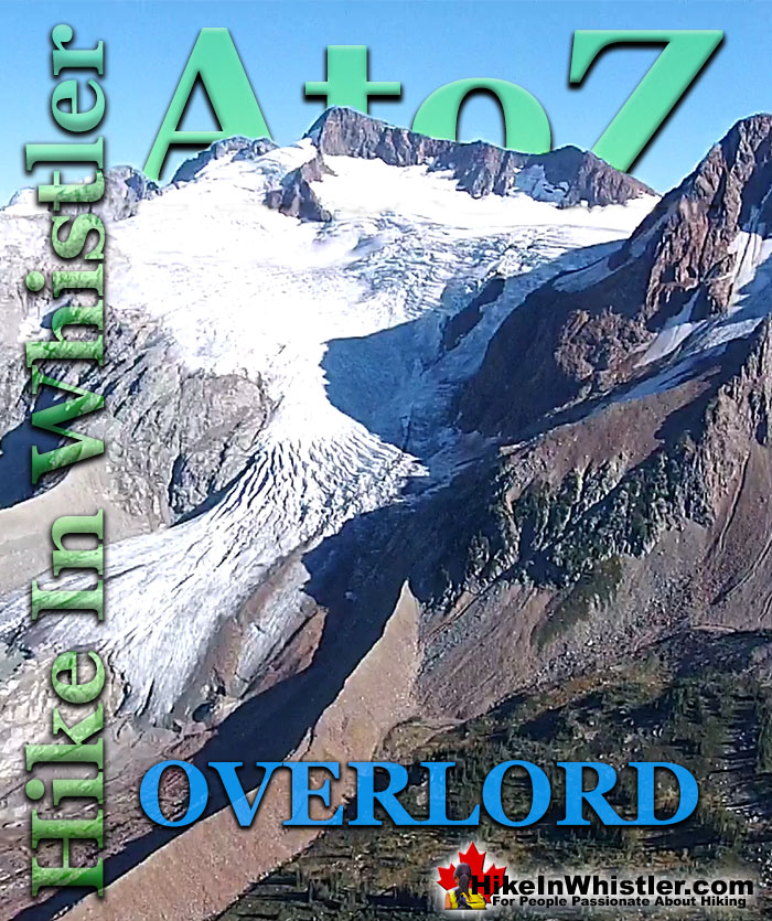
![]() Overlord Mountain is the highest peak in the Fitzsimmons Range. Overlord is surrounded by several mountains that collectively are named the Overlord Massif. Massif is a term geologists use to refer to a group of mountains that tends to move as a unit while shifted by movements of the crust. The Overlord Massif is dominated by Overlord Mountain which is impressively visible from Whistler Village, Whistler Mountain and Blackcomb Mountain.
Overlord Mountain is the highest peak in the Fitzsimmons Range. Overlord is surrounded by several mountains that collectively are named the Overlord Massif. Massif is a term geologists use to refer to a group of mountains that tends to move as a unit while shifted by movements of the crust. The Overlord Massif is dominated by Overlord Mountain which is impressively visible from Whistler Village, Whistler Mountain and Blackcomb Mountain.
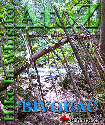
Whistler & Garibaldi Hiking
![]() Alexander Falls
Alexander Falls ![]() Ancient Cedars
Ancient Cedars ![]() Black Tusk
Black Tusk ![]() Blackcomb Mountain
Blackcomb Mountain ![]() Brandywine Falls
Brandywine Falls ![]() Brandywine Meadows
Brandywine Meadows ![]() Brew Lake
Brew Lake ![]() Callaghan Lake
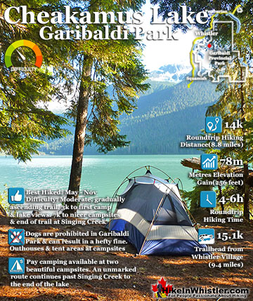
Callaghan Lake ![]() Cheakamus Lake
Cheakamus Lake ![]() Cheakamus River
Cheakamus River ![]() Cirque Lake
Cirque Lake ![]() Flank Trail
Flank Trail ![]() Garibaldi Lake
Garibaldi Lake ![]() Garibaldi Park
Garibaldi Park ![]() Helm Creek
Helm Creek ![]() Jane Lakes
Jane Lakes ![]() Joffre Lakes
Joffre Lakes ![]() Keyhole Hot Springs
Keyhole Hot Springs ![]() Logger’s Lake
Logger’s Lake ![]() Madeley Lake
Madeley Lake ![]() Meager Hot Springs
Meager Hot Springs ![]() Nairn Falls
Nairn Falls ![]() Newt Lake
Newt Lake ![]() Panorama Ridge
Panorama Ridge ![]() Parkhurst Ghost Town
Parkhurst Ghost Town ![]() Rainbow Falls
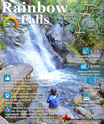
Rainbow Falls ![]() Rainbow Lake
Rainbow Lake ![]() Ring Lake
Ring Lake ![]() Russet Lake
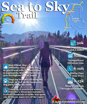
Russet Lake ![]() Sea to Sky Trail
Sea to Sky Trail ![]() Skookumchuck Hot Springs
Skookumchuck Hot Springs ![]() Sloquet Hot Springs
Sloquet Hot Springs ![]() Sproatt East
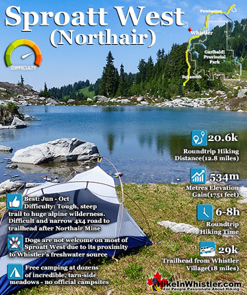
Sproatt East ![]() Sproatt West
Sproatt West ![]() Taylor Meadows
Taylor Meadows ![]() Train Wreck
Train Wreck ![]() Wedgemount Lake
Wedgemount Lake ![]() Whistler Mountain
Whistler Mountain
![]() January
January ![]() February
February ![]() March
March ![]() April
April ![]() May
May ![]() June
June ![]() July
July ![]() August
August ![]() September
September ![]() October
October ![]() November
November ![]() December
December
The collection of mountain peaks of the Overlord Massif are Overlord Mountain (2625m/8612ft), Mount Fitzsimmons (2603m/8540ft) and Mount Benvolio (2613m/8573ft). Just south of the Overlord Massif is Cheakamus Mountain (2588m/8491ft), Angelo Peak (2561m/8402ft) and Diavolo Peak (2569m/8428ft). The Overlord Massif is part of the Fitzsimmons Range, which is a subdivision of the Garibaldi Ranges which is a subdivision of the Pacific Ranges of the Coast Mountains. Deriving its name from Mount Garibaldi, the Garibaldi Ranges cover the huge stretch of mountains between two enormous river valleys. The Lillooet River valley on the east side and the Cheakamus River/Green River valley on the west. Whistler is located on the west edge of the Garibaldi Ranges, while Pemberton near the north end and Vancouver at the south end. Another subsection of the Garibaldi Ranges in the vicinity of the Fitzsimmons Range is the Spearhead Range on the Blackcomb Mountain side of the valley.


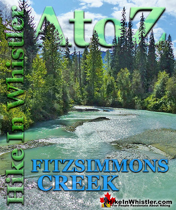
The Spearhead Range is a subsection of the Garibaldi Ranges that runs in an arc that connects Whistler Mountain and Blackcomb Mountain. The Spearhead Range is effectively the brother of the Fitzsimmons Range which runs east from the summit of Whistler Mountain to Russet Lake. The Spearhead Range covers the area on the north side or Blackcomb Mountain side of Fitzsimmons Creek. Fitzsimmons Creek cuts between Whistler Mountain and Blackcomb Mountain. Where the Fitzsimmons Range ends at Fitzsimmons Creek, the Spearhead Range begins and continues along a set of peaks resembling spearheads to Blackcomb Mountain. These peaks include The Spearhead, Mount Trorey, Tremor, Shatter, Shudder, Quiver, and more.

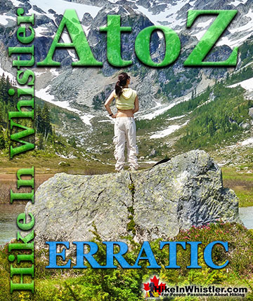
![]() The Overlord hiking trail on Blackcomb Mountain is a great way to get a beautiful look at Overlord Glacier and Overlord Mountain. The Overlord trail runs along the edge of Blackcomb Mountain and the scenic alpine forest that surrounds it. It then runs another 1.6 kilometres or 1 mile to the far end of Blackcomb Mountain before entering Garibaldi Provincial Park. An unmarked route continues deeper into Garibaldi Provincial Park, however this route is only recommended for advanced hikers as there are no trail signs and getting lost is very easy here. A better/easier route into Garibaldi Provincial Park is found on the Whistler side, where signs and mapboards direct you all the way. This is the very old and very loved, Singing Pass trail that begins next to the bus stop at the base of Whistler Mountain(close to Dubh Linn Gate Irish Pub). Along the Overlord trail you will come to two loop trails. The first one is the Lakeside Loop Trail. This moderately challenging trail takes you to Blackcomb Lake, a beautiful little alpine lake at the base of Blackcomb Peak. This crystal clear lake sits at the base of a hostile looking valley of boulders on one side and green meadows on the other. You often see a couple people braving the cold water for a swim and there is a huge erratic out in the lake perfect for laying in the sun.
The Overlord hiking trail on Blackcomb Mountain is a great way to get a beautiful look at Overlord Glacier and Overlord Mountain. The Overlord trail runs along the edge of Blackcomb Mountain and the scenic alpine forest that surrounds it. It then runs another 1.6 kilometres or 1 mile to the far end of Blackcomb Mountain before entering Garibaldi Provincial Park. An unmarked route continues deeper into Garibaldi Provincial Park, however this route is only recommended for advanced hikers as there are no trail signs and getting lost is very easy here. A better/easier route into Garibaldi Provincial Park is found on the Whistler side, where signs and mapboards direct you all the way. This is the very old and very loved, Singing Pass trail that begins next to the bus stop at the base of Whistler Mountain(close to Dubh Linn Gate Irish Pub). Along the Overlord trail you will come to two loop trails. The first one is the Lakeside Loop Trail. This moderately challenging trail takes you to Blackcomb Lake, a beautiful little alpine lake at the base of Blackcomb Peak. This crystal clear lake sits at the base of a hostile looking valley of boulders on one side and green meadows on the other. You often see a couple people braving the cold water for a swim and there is a huge erratic out in the lake perfect for laying in the sun.


More Whistler & Garibaldi Park Hiking A to Z!

The Best Whistler & Garibaldi Park Hiking Trails!
Whistler & Garibaldi Park Best Hiking by Month!


Explore BC Hiking Destinations!

Whistler Hiking Trails

Squamish Hiking Trails

Vancouver Hiking Trails

Clayoquot Hiking Trails
Victoria Hiking Trails

