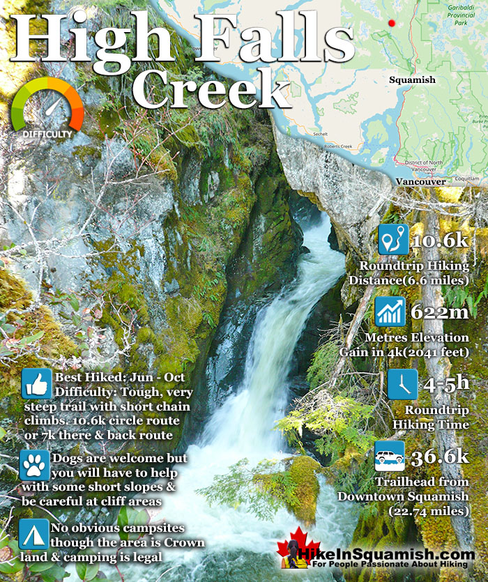
![]() The High Falls Creek hike is a great hike not only for the beautiful scenery in and around the trail, but the drive to it as well. The often passed by Squamish Valley Road, opposite the Alice Lake Provincial Park access road, is wonderful. This glacier carved valley stretches on and on, along the majestic Squamish River. The trail is well marked and though steep at times is moderately challenging.
The High Falls Creek hike is a great hike not only for the beautiful scenery in and around the trail, but the drive to it as well. The often passed by Squamish Valley Road, opposite the Alice Lake Provincial Park access road, is wonderful. This glacier carved valley stretches on and on, along the majestic Squamish River. The trail is well marked and though steep at times is moderately challenging.
 Beautiful drive up Squamish Valley
- Quieter than other Squamish trails
- Challenging, steep & fun trail
- Dog friendly with some help
- Several amazing valley viewpoints
- No campsites, but easy to find space
 No easy spots for a swim
- Not as scenic as other hikes
- Trailhead is easy to miss
- Some find the trail too hard
Squamish Hiking Trails
![]() Alice Lake
Alice Lake ![]() Black Tusk
Black Tusk ![]() Brandywine Falls
Brandywine Falls ![]() Brew Lake
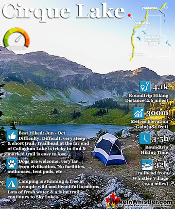
Brew Lake ![]() Cirque Lake
Cirque Lake ![]() Elfin Lakes
Elfin Lakes ![]() Garibaldi Lake
Garibaldi Lake ![]() High Falls
High Falls ![]() Levette Lake
Levette Lake ![]() Panorama Ridge
Panorama Ridge ![]() Ring Lake
Ring Lake ![]() Sea2Sky
Sea2Sky ![]() Shannon Falls
Shannon Falls ![]() The Chief
The Chief ![]() Taylor Meadows
Taylor Meadows ![]() The Lions
The Lions ![]() Upper Shannon
Upper Shannon
There are some short chain assisted areas to climb and overall the trail is fairly steep. You quickly gain 622 metres in about 4 kilometres. Past the beautiful falls viewpoints the trail leads to a few more viewpoints before ending at the Branch 200 FSR. You can either turn back and retrace your steps to the trailhead parking. Most prefer to walk the forest service road back to their car instead.
It is much longer (almost 2 kilometres longer), but it is easy and relaxing and there are some stunning views of the river valley below. This road takes you back to the S Main FSR where you will turn left onto and walk about 1.4 kilometres to get back to your car.
Tricouni Meadows and Peak are located near High Falls Creek and the Tricouni trail actually follows along High Falls Creek for some distance far above the High Falls Creek trail. To get to the Tricouni trailhead it is best to drive (instead of hiking from High Falls) as it is a few kilometres beyond the High Falls Creek trail.
Just north of Squamish, opposite the Alice Lake Provincial Park is the Squamish Valley Road (left if coming from Squamish/Vancouver, turn right if coming from Whistler). From here reset your odometer and drive for 26.5k (bear left at 3k), the last couple kilometres will be the S Main Forest Service Road. You will pass a hydroelectric power station on your right and cross a small bridge. Shortly after the power station you will see another a small bridge, this is the bridge over High Falls Creek. Park just before the bridge and walk across the bridge to see the trailhead sign to High Falls Creek immediately past it on the right.
More Best Squamish Hiking - High Falls Creek

Best Whistler & Garibaldi Park Hiking Trails!
Whistler & Garibaldi Park Hiking by Month!


Explore BC Hiking Destinations!

Whistler Hiking Trails

Squamish Hiking Trails

Vancouver Hiking Trails

Clayoquot Hiking Trails
Victoria Hiking Trails

