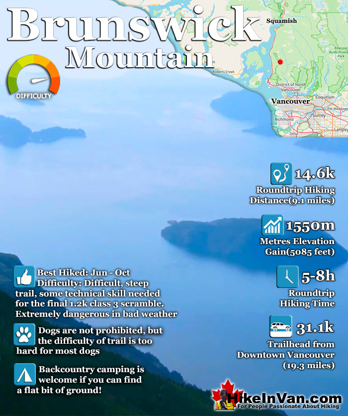
![]() Brunswick Mountain is the highest peak in the North Shore mountains. Located in the beautiful Cypress Provincial Park, Brunswick Mountain is among several other prominent summits on the amazing Howe Sound Crest Trail. You can reach Brunswick from the Howe Sound Crest Trail if you begin your hike from the Cypress Mountain Resort, however reaching it from the trailhead in Lions Bay is much shorter.
Brunswick Mountain is the highest peak in the North Shore mountains. Located in the beautiful Cypress Provincial Park, Brunswick Mountain is among several other prominent summits on the amazing Howe Sound Crest Trail. You can reach Brunswick from the Howe Sound Crest Trail if you begin your hike from the Cypress Mountain Resort, however reaching it from the trailhead in Lions Bay is much shorter.
 Located in a vast wilderness
- On the Howe Sound Crest Trail
- Gorgeous views of Howe Sound
- Camping is allowed & free
- Rewarding & difficult summit
- One of many peaks in the area
- Not a well known hiking trail
 Bad weather makes it dangerous
- Too difficult for most hikers
- Parking is hopelessly inadequate
Vancouver Hiking Trails
![]() Black Mountain
Black Mountain ![]() Brunswick Mountain
Brunswick Mountain ![]() Burnaby Lake
Burnaby Lake ![]() Burnaby Mountain
Burnaby Mountain ![]() Coliseum Mountain
Coliseum Mountain ![]() Crown Mountain
Crown Mountain ![]() Cypress Falls
Cypress Falls ![]() Deeks Peak
Deeks Peak ![]() Deep Cove
Deep Cove ![]() Deer Lake
Deer Lake ![]() Dog Mountain
Dog Mountain ![]() Goat Mountain
Goat Mountain ![]() Goldie Lake
Goldie Lake ![]() Grouse
Grouse ![]() Hollyburn Mountain
Hollyburn Mountain ![]() Kitsilano Beaches
Kitsilano Beaches ![]() Lighthouse Park
Lighthouse Park ![]() Lynn Canyon
Lynn Canyon ![]() Lynn Peak
Lynn Peak ![]() Mt Elsay
Mt Elsay ![]() Mt Fromme
Mt Fromme ![]() Mt Hanover
Mt Hanover ![]() Mt Harvey
Mt Harvey ![]() Mt Seymour
Mt Seymour ![]() Mt Strachan
Mt Strachan ![]() Mystery Lake
Mystery Lake ![]() Pacific Spirit
Pacific Spirit ![]() Rice Lake
Rice Lake ![]() St Mark's
St Mark's ![]() Stanley Park
Stanley Park ![]() The Lions
The Lions ![]() Unnecessary
Unnecessary
This trailhead is also used to reach The Lions, Mount Harvey and Mount Hanover. The trail is challenging as you gain considerable elevation in a short distance, 1550 metres in just 7.3k. The first half of the trail is fairly easy as you follow first a disused logging road for about 15 minutes (bear right at a fork), then a wide and fairly straight trail for another 20 minutes until you reach another junction. Take the trail (overgrown logging road) to the left which is well marked with flagging tape. You will shortly cross Magnesia Creek and the trail steepens as the logging road/trail becomes a trail and soon you will see a fork. Take the right fork and follow several switchbacks until you reach a ridge leading up to Brunswick Mountain. This final ridge ascent is very steep and exposed (class 3 scramble for about 1 kilometre), which can be very dangerous in poor weather. People have been airlifted from this section in the past due to poor weather moving in quickly to leave them unable to see. Unable to see you can find yourself unable to find your way up or down safely and the more you continue, the worse your situation becomes.
Brunswick Mountain is part of the amazing Howe Sound Crest Trail in Cypress Provincial Park and is one of the many beautiful peaks to be climbed if desired on the 29k trail. Among the hiker friendly mountains (in order from Cypress north) on the Howe Sound Crest Trail are: Mount Strachan, St Mark`s Summit, Unnecessary Mountain, The Lions, Mount Harvey, Mount Hanover, Brunswick Mountain and finally Deeks Peak.
The trailhead to Brunswick Mountain is tricky to find. It is located town of Lions Bay which is about an hours drive from downtown Vancouver or a half hour south of Squamish. From either direction on the Sea to Sky Highway, take the Lions Bay exit onto Oceanview Road (the 2nd Lions bay exit from either direction), then immediately turn left onto Cross Creek Road, then right onto Centre Road, then left onto Bayview Road, then left onto Mountain Drive, left again onto Sunset Road and park near the black gate at the dead end. Be sure to park legally as they actively tow illegally parked cars. More parking is available at the school 1 kilometre from here.
Discover Brunswick Mountain at HikeInVan.com

Best Whistler & Garibaldi Park Hiking Trails!
Whistler & Garibaldi Park Hiking by Month!


Explore BC Hiking Destinations!

Whistler Hiking Trails

Squamish Hiking Trails

Vancouver Hiking Trails

Clayoquot Hiking Trails
Victoria Hiking Trails

