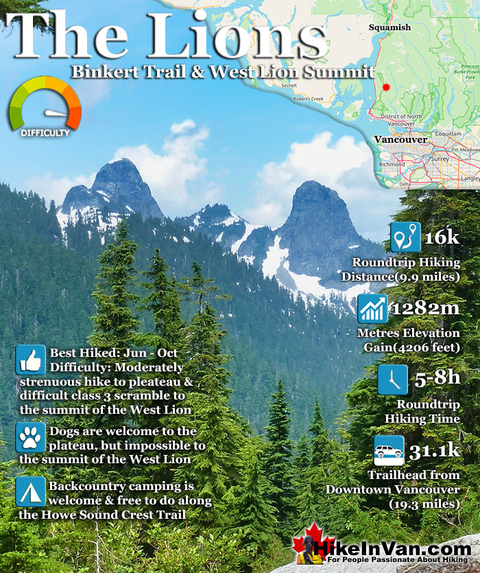
![]() The Lions or Twin Sisters lie in North Vancouver, south of Squamish. The two distinct, rocky peaks are visible from downtown Vancouver. The one on the left, the one pictured above, can be climbed. You don't have to, however, as the plateau before this difficult summit has amazing views. In fact, most finish their hike to The Lions here at this wonderful(second) plateau with the towering West Lion so close.
The Lions or Twin Sisters lie in North Vancouver, south of Squamish. The two distinct, rocky peaks are visible from downtown Vancouver. The one on the left, the one pictured above, can be climbed. You don't have to, however, as the plateau before this difficult summit has amazing views. In fact, most finish their hike to The Lions here at this wonderful(second) plateau with the towering West Lion so close.
 Iconic Vancouver mountains
- Difficult & very rewarding summit
- Lots to see before the summit climb
- Part of the Howe Sound Crest Trail
- Free backcountry camping
- Dogs are welcome on the trail
- Surreal to see The Lions up close
- Amazing Howe Sound Views
 Parking is absurdly inadequate
- Half the trail is steep & boring
Vancouver Hiking Trails
![]() Black Mountain
Black Mountain ![]() Brunswick Mountain
Brunswick Mountain ![]() Burnaby Lake
Burnaby Lake ![]() Burnaby Mountain
Burnaby Mountain ![]() Coliseum Mountain
Coliseum Mountain ![]() Crown Mountain
Crown Mountain ![]() Cypress Falls
Cypress Falls ![]() Deeks Peak
Deeks Peak ![]() Deep Cove
Deep Cove ![]() Deer Lake
Deer Lake ![]() Dog Mountain
Dog Mountain ![]() Goat Mountain
Goat Mountain ![]() Goldie Lake
Goldie Lake ![]() Grouse
Grouse ![]() Hollyburn Mountain
Hollyburn Mountain![]() Kitsilano Beaches
Kitsilano Beaches ![]() Lighthouse Park
Lighthouse Park ![]() Lynn Canyon
Lynn Canyon ![]() Lynn Peak
Lynn Peak ![]() Mt Elsay
Mt Elsay ![]() Mt Fromme
Mt Fromme ![]() Mt Hanover
Mt Hanover ![]() Mt Harvey
Mt Harvey ![]() Mt Seymour
Mt Seymour ![]() Mt Strachan
Mt Strachan ![]() Mystery Lake
Mystery Lake ![]() Pacific Spirit
Pacific Spirit ![]() Rice Lake
Rice Lake ![]() St Mark's
St Mark's ![]() Stanley Park
Stanley Park ![]() The Lions
The Lions ![]() Unnecessary
Unnecessary
It is beautiful enough, tough, and very rewarding to get to this plateau. To get to the West Lions summit is considerably more challenging and comparatively more rewarding. The view from the top of the West Lion is spectacular. Howe Sound stretches out into the blue distance. A tough but wonderful hike in easy conditions. In wet, cold, or snowy weather, a summit attempt is very treacherous. Not only is cold, snowy, icy or wet weather a consideration due to the slippery footing and hand holds, but also cloudy and foggy weather. Fog can reduce visibility enough to make finding your way, and more importantly, finding your return route, difficult to find. Losing your way from the top of the West Lion has proven fatal in the past. The first half of the Lions Binkert Trail is very easy as you follow a disused, though beautifully overgrown logging road gently uphill. After the first 30 minutes of hiking you come to a Y junction, take the path on the right and continue as the path eventually narrows and beautiful views of Howe Sound become visible. You will pass two waterfalls, then come to a sign (The Lions>>) that blocks the old, very overgrown logging road and points to a narrow path to the right. You will cross Harvey Creek over a beautiful little bridge with wonderful views, then the first significant uphill hiking starts. From this point on the trail is very well marked with flagging tape, tree markers and paint indicators on the rock faces.
The Lions from St Mark's Summit

There are two plateaus before the final, very difficult ascent to the summit of the West Lion. Both plateaus have incredible views and most make the second plateau their final destination. It is at the base of the West Lion. There are not really any suitable or marked places to put up a tent, but if you had to choose, somewhere in the vicinity of these two plateaus would be the place to do it. If you continue to the summit be prepared for a four metre rope descent. The ropes are there, fixed to a tree above, but are alarmingly worn. If you have ropes, you may want to bring them for this part. After this, you will cross the narrow col connecting to the West Lion.
Approaching The West Lion

This begins the difficult, class 3 section. Easy if you are a seasoned climber, though very difficult if you are an average hiker. Keep in mind that going up is not too challenging, however, climbing down is tricky and dangerous. Clinging to narrow rocks and ledges you have to make your way around the right hand side of the steep West Lion. This section is so dangerous that there are permanent ropes fixed in places to prevent you falling several dozens of metres if you lost your grip. There is one section of rope now missing which is a bit unsettling.
The Final Steep Climb to the West Lion Summit

The East Lion summit is in the watershed area and is forbidden to climb. The West Lion is just outside the watershed and climbable. It is however, quite difficult and the wet and cloudy climate make it somewhat dangerous. In September 2006 two climbers after reaching the West Lion Summit and smoking celebratory cigars began their descent. Unfortunately the all-too-common fog of Vancouver had engulfed the mountain and they lost the trail. They reportedly attempted to climb back to the summit and find the ascent trail again, however, at a free climb of a small cliff one of the hikers fell 100 metres to his death. A combination of fog, wet and loose rock holds caused this tragedy.

Discover The Lions at HikeInVan.com

Best Whistler & Garibaldi Park Hiking Trails!
Whistler & Garibaldi Park Hiking by Month!


Explore BC Hiking Destinations!

Whistler Hiking Trails

Squamish Hiking Trails

Vancouver Hiking Trails

Clayoquot Hiking Trails
Victoria Hiking Trails

