![]() May is an extraordinarily beautiful time of year in Whistler. The days are longer and warmer and a great lull in between seasons happens. Whistler is fairly quiet in May and nobody goes hiking. This is because most of the trails have quite deep snow. This keeps everyone away, and for good reason. The best Garibaldi Park and Whistler area trails are mostly steep and at high elevations, so hiking or snowshoeing in deep snow is exhausting.
May is an extraordinarily beautiful time of year in Whistler. The days are longer and warmer and a great lull in between seasons happens. Whistler is fairly quiet in May and nobody goes hiking. This is because most of the trails have quite deep snow. This keeps everyone away, and for good reason. The best Garibaldi Park and Whistler area trails are mostly steep and at high elevations, so hiking or snowshoeing in deep snow is exhausting.
Whistler & Garibaldi Hiking
![]() Alexander Falls
Alexander Falls ![]() Ancient Cedars
Ancient Cedars ![]() Black Tusk
Black Tusk ![]() Blackcomb Mountain
Blackcomb Mountain ![]() Brandywine Falls
Brandywine Falls ![]() Brandywine Meadows
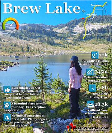
Brandywine Meadows ![]() Brew Lake
Brew Lake ![]() Callaghan Lake
Callaghan Lake ![]() Cheakamus Lake
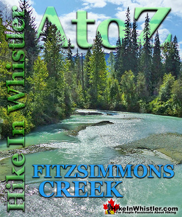
Cheakamus Lake ![]() Cheakamus River
Cheakamus River ![]() Cirque Lake
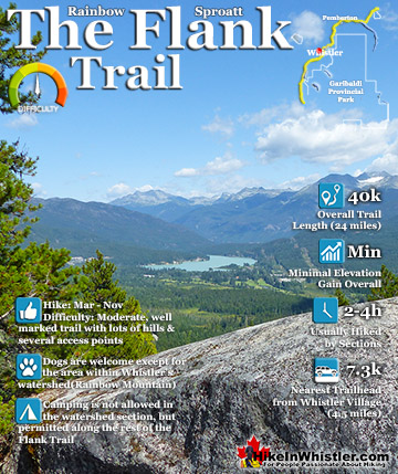
Cirque Lake ![]() Flank Trail
Flank Trail ![]() Garibaldi Lake
Garibaldi Lake ![]() Garibaldi Park
Garibaldi Park ![]() Helm Creek
Helm Creek ![]() Jane Lakes
Jane Lakes ![]() Joffre Lakes
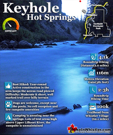
Joffre Lakes ![]() Keyhole Hot Springs
Keyhole Hot Springs ![]() Logger’s Lake
Logger’s Lake ![]() Madeley Lake
Madeley Lake ![]() Meager Hot Springs
Meager Hot Springs ![]() Nairn Falls
Nairn Falls ![]() Newt Lake
Newt Lake ![]() Panorama Ridge
Panorama Ridge ![]() Parkhurst Ghost Town
Parkhurst Ghost Town ![]() Rainbow Falls
Rainbow Falls ![]() Rainbow Lake
Rainbow Lake ![]() Ring Lake
Ring Lake ![]() Russet Lake
Russet Lake ![]() Sea to Sky Trail
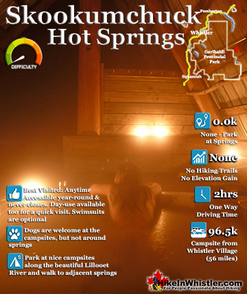
Sea to Sky Trail ![]() Skookumchuck Hot Springs
Skookumchuck Hot Springs ![]() Sloquet Hot Springs
Sloquet Hot Springs ![]() Sproatt East
Sproatt East ![]() Sproatt West
Sproatt West ![]() Taylor Meadows
Taylor Meadows ![]() Train Wreck
Train Wreck ![]() Wedgemount Lake
Wedgemount Lake ![]() Whistler Mountain
Whistler Mountain
![]() January
January ![]() February
February ![]() March
March ![]() April
April ![]() May
May ![]() June
June ![]() July
July ![]() August
August ![]() September
September ![]() October
October ![]() November
November ![]() December
December
But if that doesn't bother you, then you have a lot to look forward to in Whistler in May. Cheakamus Lake is great in May and this year the trail has been snow free for weeks already! Other Garibaldi Park hikes are also great in May, though tougher due to alpine snow. Taylor Meadows, Garibaldi Lake are great, and not terribly hard, but snowshoes might be necessary, depending on how much the snow is packed down from other hikers. Panorama Ridge and Black Tusk are pretty exhausting with the added difficulty of snow, but considerably more amazing and rewarding. May is also the month where the road to Sloquet Hot Springs becomes free of snow and you can drive right to the hot springs campsite. A hot springs trip for two or three days going to both Skookumchuck and Sloquet makes for an amazing couple days. The waterfalls around Whistler are great in May. Alexander Falls may have lots of snow, but only a few dozen metres of it to walk through to the viewpoint. Rainbow Falls will be free of snow in May as well as Brandywine Falls and Nairn Falls. Check out all of Whistler's amazing waterfalls here..
Beautiful Cheakamus Lake

Joffre Lakes - Best Whistler Hiking in May
![]() Joffre Lakes is possibly the best hike in and around Whistler in May. The snow disappears faster from the trail there, and what snow remains is consistently packed down by skiers, snowshoers and hikers. To hike Joffre Lakes in May you just need good warm clothes, good waterproof shoes for the mud and snow patches and the foresight or luck to go on a sunny day. The lake is amazing in good weather and dismal in grey weather. There are three lakes and they get progressively more beautiful. By the third lake the intense blue is breathtaking. The mighty Matier Glacier rises above the third lake, making the experience even more spectacular. The trail is rough and tricky in some parts, but not terribly difficult. The trail is 5.5km to the third lake so give yourself 1.5 - 2 hours(one way). Unfortunately, as of the Summer of 2018 Joffre Lakes Park is no longer dog friendly. Why should you hike the Joffre Lakes trail in May? The drive to the trailhead is beautiful and you can see some interesting sights on the way from Whistler. Nairn Falls, the cute town of Pemberton, North Arm Farm and great views of Lillooet Lake are all convenient pit stops on the 1.5 hour drive to Joffre Lakes. The lakes are extremely beautiful and accessible for only a moderately difficult, family friendly hike.
Joffre Lakes is possibly the best hike in and around Whistler in May. The snow disappears faster from the trail there, and what snow remains is consistently packed down by skiers, snowshoers and hikers. To hike Joffre Lakes in May you just need good warm clothes, good waterproof shoes for the mud and snow patches and the foresight or luck to go on a sunny day. The lake is amazing in good weather and dismal in grey weather. There are three lakes and they get progressively more beautiful. By the third lake the intense blue is breathtaking. The mighty Matier Glacier rises above the third lake, making the experience even more spectacular. The trail is rough and tricky in some parts, but not terribly difficult. The trail is 5.5km to the third lake so give yourself 1.5 - 2 hours(one way). Unfortunately, as of the Summer of 2018 Joffre Lakes Park is no longer dog friendly. Why should you hike the Joffre Lakes trail in May? The drive to the trailhead is beautiful and you can see some interesting sights on the way from Whistler. Nairn Falls, the cute town of Pemberton, North Arm Farm and great views of Lillooet Lake are all convenient pit stops on the 1.5 hour drive to Joffre Lakes. The lakes are extremely beautiful and accessible for only a moderately difficult, family friendly hike.

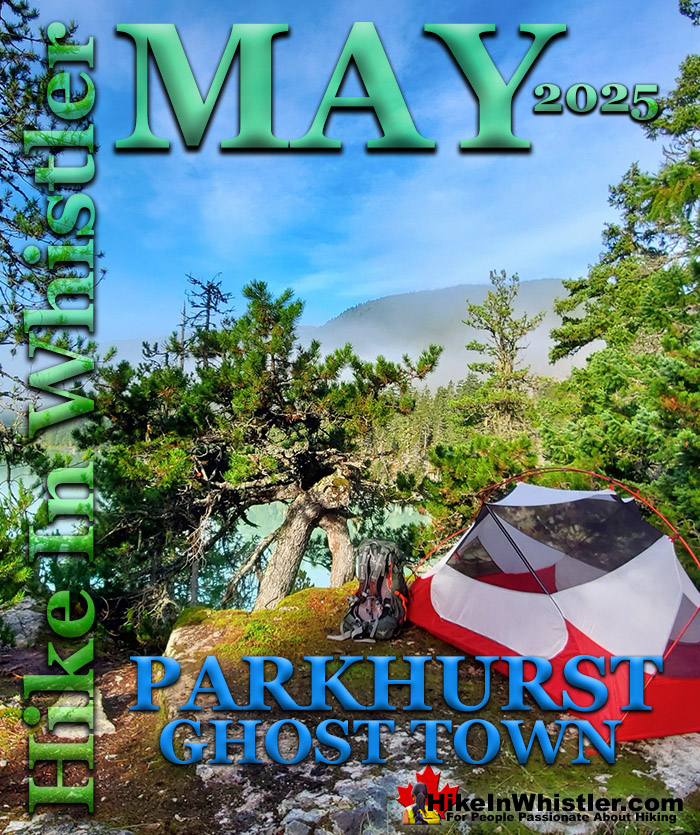
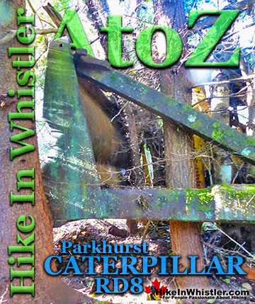
Parkhurst Ghost Town - Best Whistler Hiking in May
![]() Whistler has an absurd number of wonderful and free hiking trails and Parkhurst Ghost Town certainly ranks as one of the most unusual, exotic and interesting. Parkhurst was a little logging town perched on the edge of Green Lake way before Whistler was Whistler. Up on the ridge where Parkhurst sits, the views are sensational. Green Lake far below, a solid unnatural looking mass of green. Blackcomb Mountain and Whistler Mountain out in the distance to the left and Rainbow Mountain across and beyond the lake. If you have a good look around Parkhurst today, you can find remnants of its past almost everywhere you look. From the old disintegrating truck from the 50's to the absurdly and improbably located car being consumed by the forest. What makes Parkhurst Ghost Town such a great hiking trail and destination is where it is located and the trail to get to it. Continued here...
Whistler has an absurd number of wonderful and free hiking trails and Parkhurst Ghost Town certainly ranks as one of the most unusual, exotic and interesting. Parkhurst was a little logging town perched on the edge of Green Lake way before Whistler was Whistler. Up on the ridge where Parkhurst sits, the views are sensational. Green Lake far below, a solid unnatural looking mass of green. Blackcomb Mountain and Whistler Mountain out in the distance to the left and Rainbow Mountain across and beyond the lake. If you have a good look around Parkhurst today, you can find remnants of its past almost everywhere you look. From the old disintegrating truck from the 50's to the absurdly and improbably located car being consumed by the forest. What makes Parkhurst Ghost Town such a great hiking trail and destination is where it is located and the trail to get to it. Continued here...


Alexander Falls - Best Whistler Hiking in May
![]() Alexander Falls is a very impressive 43 metre/141foot waterfall just 30 minutes south of Whistler in the Callaghan Valley. There is a nice viewing platform on the edge of the cliff across from the falls which crash fantastically into the valley below. The parking area and viewing platform at Alexander Falls is one big area just 40 metres from the main road. Of impressive waterfalls in the Whistler area, Alexander Falls is one of several spectacular ones. Others in and around Whistler are Brandywine Falls, Rainbow Falls, and Nairn Falls. Along very difficult hike to Wedgemount Lake you will see the incredible Wedgemount Falls. Down in Squamish, 45 minutes south of Whistler, you will find Shannon Falls. Why should you go to Alexander Falls in May? Alexander Falls is massive and beautiful. It's convenient and easy - you can drive right to it with no hiking involved. It's near the end of a beautiful drive up the Callaghan Valley. In the months without snow you will see multiple bears along the road in the last couple kilometres before Alexander Falls. There are bear watching companies that specifically drive to this area on their tours. Seeing Alexander Falls can be combined with other sights such as Whistler Olympic Park, Callaghan Lake, and Madeley Lake.
Alexander Falls is a very impressive 43 metre/141foot waterfall just 30 minutes south of Whistler in the Callaghan Valley. There is a nice viewing platform on the edge of the cliff across from the falls which crash fantastically into the valley below. The parking area and viewing platform at Alexander Falls is one big area just 40 metres from the main road. Of impressive waterfalls in the Whistler area, Alexander Falls is one of several spectacular ones. Others in and around Whistler are Brandywine Falls, Rainbow Falls, and Nairn Falls. Along very difficult hike to Wedgemount Lake you will see the incredible Wedgemount Falls. Down in Squamish, 45 minutes south of Whistler, you will find Shannon Falls. Why should you go to Alexander Falls in May? Alexander Falls is massive and beautiful. It's convenient and easy - you can drive right to it with no hiking involved. It's near the end of a beautiful drive up the Callaghan Valley. In the months without snow you will see multiple bears along the road in the last couple kilometres before Alexander Falls. There are bear watching companies that specifically drive to this area on their tours. Seeing Alexander Falls can be combined with other sights such as Whistler Olympic Park, Callaghan Lake, and Madeley Lake.


Whistler Train Wreck - Best Whistler Hiking in May
![]() The Whistler Train Wreck trail is free of snow in May and beautiful to hike. It is hard to say enough about the Whistler Train Wreck. It is fantastic for so many reasons. First, its location. Just a short 10 minute drive gets you to the trailhead parking, just off of the Sea to Sky Highway at the intersection at Function Junction. The hike begins just down from the Whistler Interpretive Forest parking lot at the Flank Trail trailhead. Immediately you are deep in the forest, then the trail bends left and under the Sea to Sky Highway. Through a narrow forest, now with the highway on your right. The trail then crosses the train tracks and you arrive at some amazing views of the Cheakamus River. The trail then runs along the river to more amazing viewpoints, then forces you back toward the train tracks. Around a bend in the river, another trail, visible from the train tracks again heads into the trees on your left. Once again phenomenal views of the crashing river and then the amazing train wrecks come into view. They are amazing. Graffiti style paint brings the dingy wreckage to life with shockingly beautiful colours. The huge wrecks are enormous up close and mangled. Some on their sides, some upside down. Each one (there are several) is an interesting adventure to explore. A sort of wilderness art exhibit. The wreckage stretches for almost a kilometre and can bring out the kid in anyone. The area is very kid friendly as the trails are wide and generally flat. There are several extraordinarily surreal places to put up a tent or, as many often do, sleep on the edge of the incredible river or even in a wrecked car. There are indications in all the cars of thousands of past gatherings which gives the place a charm that seems characteristically Whistler. Whistler Train Wreck is a spectacularly beautiful and interesting place, just like Whistler. Why should you hike Whistler Train Wreck in May? Beautiful, easy, relaxing, so much to see. Convenient, just off of the Sea to Sky Highway. Popular as a 5.4k trail running route. Whistler Train Wreck is one of the best places in Whistler for a picnic or glass of wine and a very kid friendly hike.
The Whistler Train Wreck trail is free of snow in May and beautiful to hike. It is hard to say enough about the Whistler Train Wreck. It is fantastic for so many reasons. First, its location. Just a short 10 minute drive gets you to the trailhead parking, just off of the Sea to Sky Highway at the intersection at Function Junction. The hike begins just down from the Whistler Interpretive Forest parking lot at the Flank Trail trailhead. Immediately you are deep in the forest, then the trail bends left and under the Sea to Sky Highway. Through a narrow forest, now with the highway on your right. The trail then crosses the train tracks and you arrive at some amazing views of the Cheakamus River. The trail then runs along the river to more amazing viewpoints, then forces you back toward the train tracks. Around a bend in the river, another trail, visible from the train tracks again heads into the trees on your left. Once again phenomenal views of the crashing river and then the amazing train wrecks come into view. They are amazing. Graffiti style paint brings the dingy wreckage to life with shockingly beautiful colours. The huge wrecks are enormous up close and mangled. Some on their sides, some upside down. Each one (there are several) is an interesting adventure to explore. A sort of wilderness art exhibit. The wreckage stretches for almost a kilometre and can bring out the kid in anyone. The area is very kid friendly as the trails are wide and generally flat. There are several extraordinarily surreal places to put up a tent or, as many often do, sleep on the edge of the incredible river or even in a wrecked car. There are indications in all the cars of thousands of past gatherings which gives the place a charm that seems characteristically Whistler. Whistler Train Wreck is a spectacularly beautiful and interesting place, just like Whistler. Why should you hike Whistler Train Wreck in May? Beautiful, easy, relaxing, so much to see. Convenient, just off of the Sea to Sky Highway. Popular as a 5.4k trail running route. Whistler Train Wreck is one of the best places in Whistler for a picnic or glass of wine and a very kid friendly hike.


Cheakamus Lake - Best Whistler Hiking in May
![]() Cheakamus Lake is an easy, relaxing hike in Garibaldi Park just a short, 16k drive from Whistler Village. The access road emerges from the snow and passable usually in early May, and in 2024 it was clear in April! The trail to the lake is in an amazing forest of giant cedars. Running along the beautiful Cheakamus River the hike is short and easy. The trail runs along the lake, passing some small, wonderful campsites, and very small beaches. The first 3k of the trail takes you along the beautiful Cheakamus River to the start of Cheakamus Lake and the first campsite area. There are 10 very nice and hidden tent pads on or near the lake shore. There is excellent water from several creeks in the area and a bear proof food hang as well as tidy outhouses here. Another 3k further on the trail takes you to some beautiful viewpoints on the ever increasingly majestic Cheakamus Lake trail. Huge trees, turquoise lake, snow capped mountains, and even the occasional bear siting make this hike one of Whistler's best and most family and kid friendly hikes around. The trail is never strenuous and constantly beautiful with the wonderful smells that come with an old growth cedar forest. The campsite at 6k on the Cheakamus Lake trail consists of another 7 tent sites beautifully blended into the surroundings, another bear proof food hang and outhouse. There are dozens of cute little beaches all along the trail which invite swimming in the crystal clear, though bitterly cold water. Cheakamus Lake has always been known for its good fishing so bring your rod and sit back in the sun. Which you will see a lot of. The entire trail and mini beaches are south facing and capture the sun the entire day. Why should you hike to Cheakamus Lake in May? Beautiful, huge tree forest, easy kid friendly trail, pristine Garibaldi Park wilderness and a spectacular and huge lake. Excellent campsites and numerous hidden beaches and wonderful, though very cold, swimming.
Cheakamus Lake is an easy, relaxing hike in Garibaldi Park just a short, 16k drive from Whistler Village. The access road emerges from the snow and passable usually in early May, and in 2024 it was clear in April! The trail to the lake is in an amazing forest of giant cedars. Running along the beautiful Cheakamus River the hike is short and easy. The trail runs along the lake, passing some small, wonderful campsites, and very small beaches. The first 3k of the trail takes you along the beautiful Cheakamus River to the start of Cheakamus Lake and the first campsite area. There are 10 very nice and hidden tent pads on or near the lake shore. There is excellent water from several creeks in the area and a bear proof food hang as well as tidy outhouses here. Another 3k further on the trail takes you to some beautiful viewpoints on the ever increasingly majestic Cheakamus Lake trail. Huge trees, turquoise lake, snow capped mountains, and even the occasional bear siting make this hike one of Whistler's best and most family and kid friendly hikes around. The trail is never strenuous and constantly beautiful with the wonderful smells that come with an old growth cedar forest. The campsite at 6k on the Cheakamus Lake trail consists of another 7 tent sites beautifully blended into the surroundings, another bear proof food hang and outhouse. There are dozens of cute little beaches all along the trail which invite swimming in the crystal clear, though bitterly cold water. Cheakamus Lake has always been known for its good fishing so bring your rod and sit back in the sun. Which you will see a lot of. The entire trail and mini beaches are south facing and capture the sun the entire day. Why should you hike to Cheakamus Lake in May? Beautiful, huge tree forest, easy kid friendly trail, pristine Garibaldi Park wilderness and a spectacular and huge lake. Excellent campsites and numerous hidden beaches and wonderful, though very cold, swimming.

Cheakamus River - Best Whistler Hiking in May
![]() Cheakamus River is a beautiful, crashing, turquoise coloured river that flows from Cheakamus Lake, through Whistler Interpretive Forest at Cheakamus Crossing, then down past Brandywine Falls to Daisy Lake. Also a popular kayaking route, the main attraction to Cheakamus River is the wonderful and quite extensive network of hiking and biking trails that run along either side of it. The Riverside trail and the Farside trail run on either side of Cheakamus River and connect at both ends by bridges. Connecting to the Riverside trail is the short trail to Logger's Lake, which in turn is surrounded by more hiking and biking trails. The Lake Loop trail, Crater Rim trail, the Ridge trail, Upper Ridge trail, and the Lower Ridge trail. On the Farside trail along Cheakamus River you can connect to Cheakamus Road(gravel road) and hike 6 kilometres up to the Cheakamus Lake trailhead. On the other side of the neighbourhood of Cheakamus Crossing, which Cheakamus River bends around keeping the Sea to Sky Highway and train tracks on its opposite side, you find still more hiking and biking trails. Trash trail hugs the river all the way to the beautiful bridge to Whistler Train Wreck. Or, continue past the bridge to connect with the Sea to Sky trail. For the most part, however, if you are talking about the Cheakamus River trails you are likely talking about the Farside and Riverside trails in Whistler's Interpretive Forest. Continued here...
Cheakamus River is a beautiful, crashing, turquoise coloured river that flows from Cheakamus Lake, through Whistler Interpretive Forest at Cheakamus Crossing, then down past Brandywine Falls to Daisy Lake. Also a popular kayaking route, the main attraction to Cheakamus River is the wonderful and quite extensive network of hiking and biking trails that run along either side of it. The Riverside trail and the Farside trail run on either side of Cheakamus River and connect at both ends by bridges. Connecting to the Riverside trail is the short trail to Logger's Lake, which in turn is surrounded by more hiking and biking trails. The Lake Loop trail, Crater Rim trail, the Ridge trail, Upper Ridge trail, and the Lower Ridge trail. On the Farside trail along Cheakamus River you can connect to Cheakamus Road(gravel road) and hike 6 kilometres up to the Cheakamus Lake trailhead. On the other side of the neighbourhood of Cheakamus Crossing, which Cheakamus River bends around keeping the Sea to Sky Highway and train tracks on its opposite side, you find still more hiking and biking trails. Trash trail hugs the river all the way to the beautiful bridge to Whistler Train Wreck. Or, continue past the bridge to connect with the Sea to Sky trail. For the most part, however, if you are talking about the Cheakamus River trails you are likely talking about the Farside and Riverside trails in Whistler's Interpretive Forest. Continued here...


Rainbow Falls - Best Whistler Hiking in May
![]() The short, winding, and ever-changing hiking trail to Rainbow Falls is the same as the much more popular trailhead for Rainbow Lake. The trailhead is marked as the Rainbow Trail, and the trail quickly ascends into the forest winding left, right, up and down almost constantly. 21 Mile Creek, always on your right can be either seen or heard as you hike through the forest to the somewhat hidden Rainbow Falls. For the adventurous, the best time to see Rainbow Falls is in August and September when the creek is low and you can get down to the marvelous creek bed. To get there you hike down further along another path just a hundred or so metres back. You will have passed the large, chain sawed tree along the right(creek) side of the trail. At one end of the tree you will see a very visible trail descend steeply down to the creek. You will see some beautiful views of the creek weaving its way through enormous boulders that have tumbled down over the centuries. Continued here...
The short, winding, and ever-changing hiking trail to Rainbow Falls is the same as the much more popular trailhead for Rainbow Lake. The trailhead is marked as the Rainbow Trail, and the trail quickly ascends into the forest winding left, right, up and down almost constantly. 21 Mile Creek, always on your right can be either seen or heard as you hike through the forest to the somewhat hidden Rainbow Falls. For the adventurous, the best time to see Rainbow Falls is in August and September when the creek is low and you can get down to the marvelous creek bed. To get there you hike down further along another path just a hundred or so metres back. You will have passed the large, chain sawed tree along the right(creek) side of the trail. At one end of the tree you will see a very visible trail descend steeply down to the creek. You will see some beautiful views of the creek weaving its way through enormous boulders that have tumbled down over the centuries. Continued here...


Brandywine Falls - Best Whistler Hiking in May
![]() Brandywine Falls is one of the must see sights on the way to or from Whistler. The falls drop from a 66 metre, unnaturally abrupt cliff to the valley below. It is such a popular and beautiful sight that it is a Provincial Park complete with a large and elaborate viewing platform directly opposite the falls. Located just 20 minutes south of Whistler, Brandywine Falls Provincial Park is just off of the Sea to Sky Highway. If driving from Vancouver, keep your eyes out for the Brandywine Falls sign on your right about 25 minutes north of Squamish. The parking lot is immediately off the highway and the short 1 kilometre trail takes you over then alongside the Cheakamus River to the viewing area. The only facilities in the park are pit toilets and picnic tables and there is no charge for hiking or for parking your vehicle in the park. The gate off of the highway is locked at night and in the winter so at these times you simply park at the edge of the highway and hike past the gate. In the winter you often see people strapping on snowshoes for the short trek to the falls in the snow. Brandywine Falls Provincial Park is attached to the wonderful Sea to Sky Trail which runs between and beyond Whistler and Squamish. It is a wide, gravel biking and hiking trail that will eventually extend north to Pemberton. Why should you hike to Brandywine Falls in May? Brandywine Falls is amazingly beautiful and very easy and quick to hike to. Just a 20 minute pit stop on the drive to or from Whistler allows you to see this amazing falls. Brandywine Falls and Shannon Falls, just south of Squamish are both convenient, quick and beautiful stops on the drive from Vancouver to Whistler.
Brandywine Falls is one of the must see sights on the way to or from Whistler. The falls drop from a 66 metre, unnaturally abrupt cliff to the valley below. It is such a popular and beautiful sight that it is a Provincial Park complete with a large and elaborate viewing platform directly opposite the falls. Located just 20 minutes south of Whistler, Brandywine Falls Provincial Park is just off of the Sea to Sky Highway. If driving from Vancouver, keep your eyes out for the Brandywine Falls sign on your right about 25 minutes north of Squamish. The parking lot is immediately off the highway and the short 1 kilometre trail takes you over then alongside the Cheakamus River to the viewing area. The only facilities in the park are pit toilets and picnic tables and there is no charge for hiking or for parking your vehicle in the park. The gate off of the highway is locked at night and in the winter so at these times you simply park at the edge of the highway and hike past the gate. In the winter you often see people strapping on snowshoes for the short trek to the falls in the snow. Brandywine Falls Provincial Park is attached to the wonderful Sea to Sky Trail which runs between and beyond Whistler and Squamish. It is a wide, gravel biking and hiking trail that will eventually extend north to Pemberton. Why should you hike to Brandywine Falls in May? Brandywine Falls is amazingly beautiful and very easy and quick to hike to. Just a 20 minute pit stop on the drive to or from Whistler allows you to see this amazing falls. Brandywine Falls and Shannon Falls, just south of Squamish are both convenient, quick and beautiful stops on the drive from Vancouver to Whistler.


Sea to Sky Trail - Best Whistler Hiking in May
![]() The Sea to Sky Trail is a 180 kilometre multi-use trail that runs from Squamish to D'Arcy. The trail is still under construction in many parts, however, the amazing route through Whistler is finally in place. The Whistler section of the Sea to Sky Trail is 33 kilometres long between Brandywine Falls Provincial Park and WedgeWoods Estates just north of Green Lake(north of Whistler Village). The 33 kilometre Whistler section of the Sea to Sky Trail is either paved, dirt or crushed rock and often very wide. Much of the trail just north and south of Whistler Village is wide, two lanes and paved with plenty of signs and occasional mapboards. North of Whistler Village the trail can be challenging with several hills as it rises above and beyond Parkhurst Ghost Town. South of Whistler, the paved trail ends at Cheakamus Crossing and becomes a narrow at times dirt trail with some wider sections of crushed rock. This beautiful section follows Cheakamus River making four dramatically beautiful river crossings. The Cal-Cheak area south of Cheakamus Crossing is more challenging and sometimes narrow and hilly, dirt trails. South of Cal-Cheak the forest opens up and the trail widens to the luxurious feeling, wide and hard packed gravel all the way to Brandywine Falls Provincial Park where the trail joins with the Sea to Sky Highway. The Whistler section of the Sea to Sky Trail passes near and through an amazing array of whistler sights. The always impressive Brandywine Falls Provincial Park at the southern end of the 33 kilometre area shown here. Heading north from Brandywine Falls you cross the huge bungee jumping bridge that spans the enormous chasm over the Cheakamus River. Soon after you cross the suspension bridge at the Cal-Cheak Recreation area. Continued here...
The Sea to Sky Trail is a 180 kilometre multi-use trail that runs from Squamish to D'Arcy. The trail is still under construction in many parts, however, the amazing route through Whistler is finally in place. The Whistler section of the Sea to Sky Trail is 33 kilometres long between Brandywine Falls Provincial Park and WedgeWoods Estates just north of Green Lake(north of Whistler Village). The 33 kilometre Whistler section of the Sea to Sky Trail is either paved, dirt or crushed rock and often very wide. Much of the trail just north and south of Whistler Village is wide, two lanes and paved with plenty of signs and occasional mapboards. North of Whistler Village the trail can be challenging with several hills as it rises above and beyond Parkhurst Ghost Town. South of Whistler, the paved trail ends at Cheakamus Crossing and becomes a narrow at times dirt trail with some wider sections of crushed rock. This beautiful section follows Cheakamus River making four dramatically beautiful river crossings. The Cal-Cheak area south of Cheakamus Crossing is more challenging and sometimes narrow and hilly, dirt trails. South of Cal-Cheak the forest opens up and the trail widens to the luxurious feeling, wide and hard packed gravel all the way to Brandywine Falls Provincial Park where the trail joins with the Sea to Sky Highway. The Whistler section of the Sea to Sky Trail passes near and through an amazing array of whistler sights. The always impressive Brandywine Falls Provincial Park at the southern end of the 33 kilometre area shown here. Heading north from Brandywine Falls you cross the huge bungee jumping bridge that spans the enormous chasm over the Cheakamus River. Soon after you cross the suspension bridge at the Cal-Cheak Recreation area. Continued here...

Sproatt East Trail - Best Whistler Hiking in May
![]() The Sproatt East trail is a beautifully wild, steep, but relatively short trail to the magnificent, wide open alpine and summit of Mount Sproatt. Mount Sproatt (1834 metres) towers over Whistler Valley directly across from Whistler Mountain (2181 metres) and Blackcomb Mountain (2436 metres). There are several routes and trails to access Sproatt and the Sproatt East trail is arguably the shortest and certainly the most convenient from Whistler. The trail begins high up in Stonebridge, the luxurious Whistler neighbourhood that extends up the valley above Alta Lake along the lower part of Mount Sproatt. From the trailhead in Stonebridge to the summit of Sproatt you gain over a thousand metres(3280 feet) in just 5.5 kilometres(3.4 miles). The steepness of the trail is comparable to the trail to Wedgemount Lake where you gain 1220 metres(4003 feet) in just 7 kilometres(4.4 miles). The Sproatt East trail quickly ascends from the Flank Trail into a stunningly varied array of deep jungle-like rainforest, to boulder strewn valleys, to spectacular rock outcrops above the treetops overlooking Whistler Valley. One minute you are hiking over dry, rocky terrain under the hot sun, then suddenly you are enveloped in deep, dark forest with idyllic streams flowing across the trail. Often you round a bend and find yourself facing a vertical wall of rock dozens of metres tall. You find yourself staring in wonder at the staggering size and what the view must be like at the top. The trail tends to bend around the base of these monoliths and almost always leads up to an access route to the top. This is one of the great features of the trail is the seemingly endless array of towering cliffs overlooking Whistler far below.
The Sproatt East trail is a beautifully wild, steep, but relatively short trail to the magnificent, wide open alpine and summit of Mount Sproatt. Mount Sproatt (1834 metres) towers over Whistler Valley directly across from Whistler Mountain (2181 metres) and Blackcomb Mountain (2436 metres). There are several routes and trails to access Sproatt and the Sproatt East trail is arguably the shortest and certainly the most convenient from Whistler. The trail begins high up in Stonebridge, the luxurious Whistler neighbourhood that extends up the valley above Alta Lake along the lower part of Mount Sproatt. From the trailhead in Stonebridge to the summit of Sproatt you gain over a thousand metres(3280 feet) in just 5.5 kilometres(3.4 miles). The steepness of the trail is comparable to the trail to Wedgemount Lake where you gain 1220 metres(4003 feet) in just 7 kilometres(4.4 miles). The Sproatt East trail quickly ascends from the Flank Trail into a stunningly varied array of deep jungle-like rainforest, to boulder strewn valleys, to spectacular rock outcrops above the treetops overlooking Whistler Valley. One minute you are hiking over dry, rocky terrain under the hot sun, then suddenly you are enveloped in deep, dark forest with idyllic streams flowing across the trail. Often you round a bend and find yourself facing a vertical wall of rock dozens of metres tall. You find yourself staring in wonder at the staggering size and what the view must be like at the top. The trail tends to bend around the base of these monoliths and almost always leads up to an access route to the top. This is one of the great features of the trail is the seemingly endless array of towering cliffs overlooking Whistler far below.

Logger’s Lake - Best Whistler Hiking in May
![]() Logger’s Lake is an amazing little lake hidden up in the deep forest above the more well known Cheakamus River. The lake, almost unbelievably exists in a long extinct volcano. However, as soon as you see the lake up close, you quickly come to believe it. The lake sits in an almost cartoonish looking, volcano-shaped bowl, with one side of the bowl a crumbling array of truck sized boulders leading down to the lake. The crater that Logger’s Lake sits in was a volcano that pushed through the glacial ice in this valley about 10000 years ago. As the lava cooled it formed the wonderful basalt ridge that is crumbling into valley. As Logger’s Lake sits deep in this ancient volcano's vent, it is sheltered from the wind and soaks up the suns rays into the dark boulders all around. As a result makes it the warmest lake in Whistler, though most other lakes around are glacier fed(via rivers and creeks), so the comparison is not entirely fair. The surrounding cliffs and forest also add to the tranquility of the lake. Located a bit off the radar for most and requiring a short logging road drive and then a very steep, but short hike to get to also contributes to its serenity. Continued here...
Logger’s Lake is an amazing little lake hidden up in the deep forest above the more well known Cheakamus River. The lake, almost unbelievably exists in a long extinct volcano. However, as soon as you see the lake up close, you quickly come to believe it. The lake sits in an almost cartoonish looking, volcano-shaped bowl, with one side of the bowl a crumbling array of truck sized boulders leading down to the lake. The crater that Logger’s Lake sits in was a volcano that pushed through the glacial ice in this valley about 10000 years ago. As the lava cooled it formed the wonderful basalt ridge that is crumbling into valley. As Logger’s Lake sits deep in this ancient volcano's vent, it is sheltered from the wind and soaks up the suns rays into the dark boulders all around. As a result makes it the warmest lake in Whistler, though most other lakes around are glacier fed(via rivers and creeks), so the comparison is not entirely fair. The surrounding cliffs and forest also add to the tranquility of the lake. Located a bit off the radar for most and requiring a short logging road drive and then a very steep, but short hike to get to also contributes to its serenity. Continued here...


Guides to the Best of Whistler
 Best Dog Friendly Hiking Trails
Whistler is very dog friendly and the number of wonderful hiking trails that your dog will love is huge. The massively varied hiking trails range from easy, short, close to Whistler Village to challenging, long and deep in the endless wilderness around Whistler. You can find dog friendly trails in and around Whistler Village that take you through deep, dark and magical forests. Or you can drive beyond Whistler Village and take your dog to spectacular alpine lakes. Some requiring little or no hiking, while others are found after hiking challenging and long trails. Many of these places are comparatively quiet and often you and your dog will have the the wilderness to yourselves. In and around Whistler Village you have Lost Lake with its spider web of trails... Continued here.
 Best Free Whistler Camping
Whistler is surrounded by an immense wilderness dotted with spectacular, hidden lakes and amazing places to set up a tent. Decades of logging activity has left a network of forest service roads that has opened easy access to these places. Some of these you can drive to and some you may need a 4x4 to comfortably get to. Some places to camp for free you can drive to, some require a short hike and others are fairly long hikes to reach. Beautiful Callaghan Valley is home to several incredible and free places to camp. Callaghan Lake has a great free drive-to campsite just steps from this spectacular alpine lake. If you have a canoe, you can paddle to the end of Callaghan Lake and hike the short, but steep trail up to Cirque Lake. This gorgeous lake is deep in the alpine wilderness... Continued here.
 No Car? No Problem! Whistler Trails
Whistler as a resort has a wonderful car-free core. The Village Stroll runs through the heart of Whistler Village and is entirely car free. If you are visiting Whistler or living here and you don't have a car, it's no problem. On foot or on a bike you can travel the extensive network of non-motorized trails. The Valley Trail snakes through Whistler Village and extends in several directions, all of which lead to beautiful parts of Whistler. The Sea to Sky Trail and the Lost Lake trails continue this massive, car-free network of trails running almost everywhere in Whistler. When it comes to many of the best hiking trails, getting to the trailheads on foot, by bike or public transit can be tricky at best or complicated and impractical at worst. Many trailheads are far from Whistler Village and... Continued here.
 Kid Friendly Whistler Hiking Trails
There are plenty of excellent, kid and family friendly hiking trails and destinations in and around Whistler. Kid and family friendly generally means an easy and somewhat short trail that a toddler can happily manage. Some of these trails are flat enough to be stroller friendly, such as Brandywine Falls, Whistler Mountain and Blackcomb Mountain. Others such as Logger’s Lake, Cheakamus River and Madeley Lake have short enough trails to reach them that you can manage with little kids that don't want to hike too far. Some of these hikes and walks are popular and close to Whistler Village, like Whistler Mountain, Blackcomb Mountain, Lost Lake Park, Rainbow Park and Meadow Park. Others are a beautiful, but far drive into the mountains and tricky to find... Continued here.
 Best Sights Sea to Sky 99
The Sea to Sky Highway links Vancouver to Whistler and has several stops along the way that are often overlooked. Porteau Cove, for example, is surprisingly unknown even to locals that have driven past hundreds of times. Just off the highway the parking area is just steps from the huge pier stretching way out over the ocean. This gigantic pier is actually a rarely used emergency dock for BC Ferries, though more often used by visitors for its stunning views of Howe Sound. Porteau Cove is an excellent pit stop on the way to Whistler, not only for the spectacular views of Howe Sound, but one of the nicest picnic spots and most convenient restrooms! Other attractions along the Sea to Sky Highway are more obvious, such as Shannon Falls, the Sea to Sky Gondola... Continued here.
 Best Whistler Waterfalls
There are lots of beautiful waterfalls in and around Whistler. From the towering drop of Brandywine Falls to the awesome, up close and breathtaking view of Keyhole Falls. Some are absurdly convenient and easy to see and others require some tough hiking, or tricky driving to get to. All of them, however, are well worth a visit. Brandywine Falls is the most well known, impressive and easy to find along the Sea to Sky Highway. The viewing platform positioned across from the falls gives you a direct view of its 66 metre(216 feet) plunge into the chasm below. Located 17.1 kilometres(10.6 miles) from Whistler Village. The short, 1 kilometre long, dog friendly trail to the viewpoint is wide and smooth gravel. Alexander Falls, located up... Continued here.
Hiking in Whistler and Garibaldi Park by Month!


Whistler Hiking Glossary A to Z

Whistler, Garibaldi Park & Sea to Sky Hiking Trails!