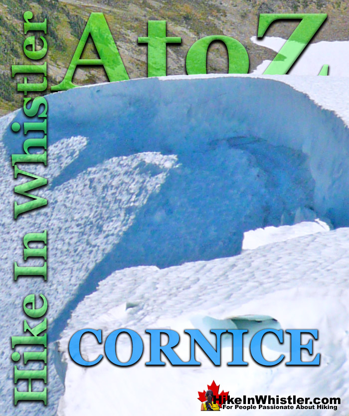
Cornice: a wind deposited wave of snow on a ridge, often overhanging a steep slope or cliff. They are the result of snow building up on the crest of a mountain. Cornices are extremely dangerous to travel on or below. A common refrain of climbers is that if you can see the drop-off of a cornice, you are too close to the edge. Cornices are dangerous for several reasons. They can collapse from hiking across or they can collapse from above.
A third danger to consider is the fact that they can often trigger a massive avalanche that extends a considerable distance from its starting point. The cornice shown in the above and below images are of Panorama Ridge in Garibaldi Provincial Park, Whistler. Panorama Ridge is easily one of the most amazing hikes in Garibaldi Provincial Park. The 15 kilometre hike from the trailhead at Rubble Creek to Panorama Ridge takes you through beautiful and deep forests, across countless idyllic streams, through meadows filled with flowers, and past dozens of jaw dropping viewpoints. The amazing views start once you reach Taylor Meadows and get even more spectacular as the trail progresses. Once you arrive at Panorama Ridge and its phenomenal vantage point, high above Garibaldi Park, you will stare in wonder. Mesmerized first by Garibaldi Lake, far below you and looking unnaturally blue, the lake looks amazing surrounded by green, untouched wilderness and snow capped mountains. The main trailhead for Panorama Ridge is at Rubble Creek, 25 kilometres south of Whistler Village on the Sea to Sky Highway you will see a Garibaldi Park sign indicating the turnoff. From the highway a paved road runs for 2 kilometres to the Rubble Creek trailhead and parking area. This is the most popular and close trailhead for Garibaldi Lake, Taylor Meadows and Black Tusk as well as Panorama Ridge.
More Whistler & Garibaldi Park Hiking A to Z!
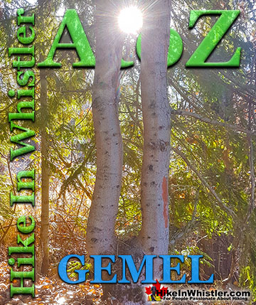
Inosculation is the technical name for two or more trees that have fused together into a single bizarre looking tree. They are colloquially known as ...
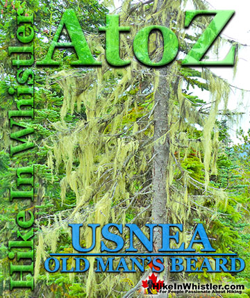
The pale green shub-like growths hanging from trees in the forests around Whistler is called usnea. These bushy, coral-like fruticose lichens anchor to bark ...
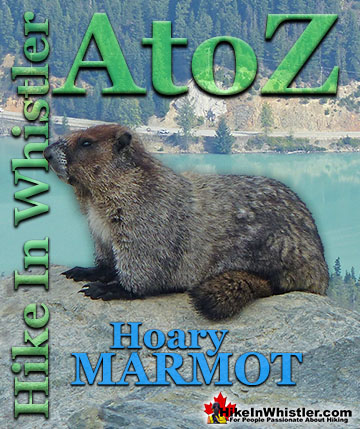
Hoary Marmots are the cute, pudgy, twenty plus pound ground squirrels that have evolved to live quite happily in the hostile alpine areas around Whistler. ...
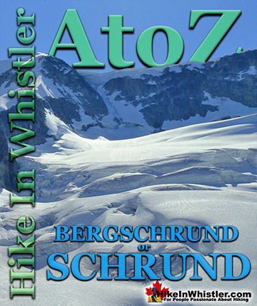
Bergschrund or abbreviated schrund: a crevasse that forms from the separation of moving glacier ice from the stagnant ice above. Characterized by a deep ...
Whistler can be expensive. Everything worth doing seems to cost a lot of money. But if you step back from the noise and crowds you may spot some secret ...
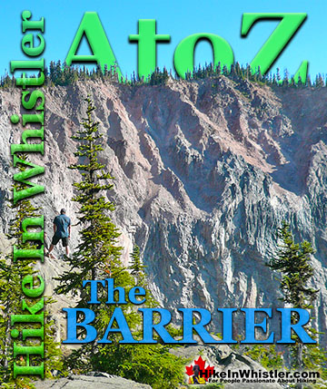
The Barrier formed as a result of huge lava flows from Clinker Peak on the west shoulder of Mount Price during the last ice age. About thirteen thousand ...
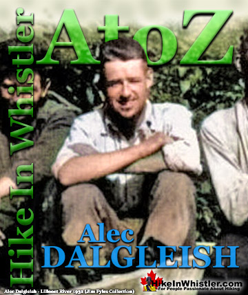
Alec Dalgleish (1 August 1907 - 26 June 1934) was a highly respected mountaineer and climber out of Vancouver in the 1920's and 1930's. His enthusiasm and ...
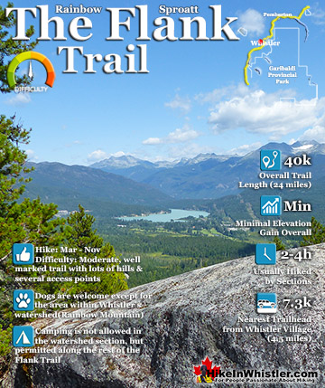
Hiking and biking trails are so abundant in Whistler that many go unnoticed, neglected or taken for granted. The Flank Trail is one of these. Most people in Whistler don't even know about it, but the ones ...
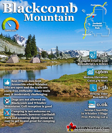
Blackcomb Mountain holds an impressive and ever growing array of hiking trails. From the moment you arrive at the Rendezvous Lodge, you see hiking trails ascend into the distance. The Rendezvous Lodge is ...
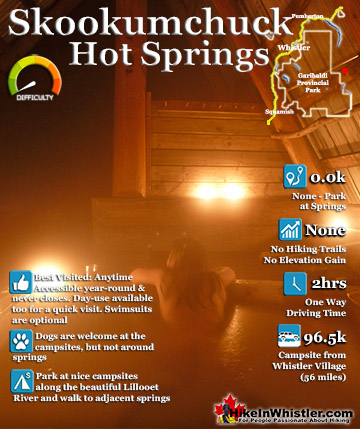
Skookumchuck Hot Springs(aka T'sek Hot Springs and St. Agnes Well), located two hours north of Whistler along the edge of the huge Lillooet River. The name Skookumchuck means "strong water" in the language ...
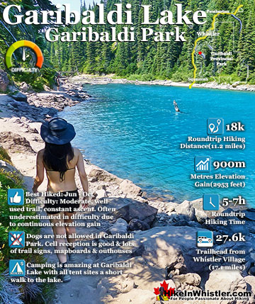
Garibaldi Lake is the centre and base for much of the hiking in Garibaldi Provincial Park. The Garibaldi Lake campsite is located on the amazing, turquoise shores of this massive and mostly still wild ...
Hiking in Whistler in October is often unexpectedly stunning. The days are much shorter and colder but the mountains are alive with colour from the fall ...
November in Whistler is when the temperatures plummet and the first heavy snow falls in the alpine and often in Whistler Village. The hiking opportunities become ...
December hiking in Whistler is mainly done on snowshoes, though not always. If it hasn't snowed much recently then trails such as Whistler Train Wreck and ...
Hiking in Whistler is spectacular and wonderfully varied. Looking at a map of Whistler you see an extraordinary spider web of hiking trails that are unbelievably numerous. Easy trails, moderate trails and challenging hiking trails are all available. Another marvellous ...
Squamish is located in the midst of a staggering array of amazing hiking trails. Garibaldi Provincial Park sprawls alongside Squamish and up and beyond Whistler. Tantalus Provincial Park lays across the valley to the west and the wonderfully remote Callaghan Valley ...
Clayoquot Sound has a staggering array of hiking trails within it. Between Tofino and Ucluelet, Pacific Rim Park has several wilderness and beach trails, each one radically different from the last. The islands in the area are often Provincial parks on their own with ...
Victoria has a seemingly endless number of amazing hiking trails. Most take you to wild and beautiful Pacific Ocean views and others take you to tranquil lakes in beautiful BC Coastal Rainforest wilderness. Regional Parks and Provincial Parks are everywhere you turn in ...
The West Coast Trail was created after decades of brutal and costly shipwrecks occurred along the West Coast of Vancouver Island. One shipwreck in particular was so horrific, tragic and unbelievable that it forced the creation of a trail along the coast, which ...