![]() Vancouver is surrounded by seemingly endless hiking trails and mountains to explore. Massive parks line up one after another. Mount Seymour Provincial Park, Lynn Canyon Park, Grouse Mountain, Cypress Park and the enormous Garibaldi Park all contribute to Vancouver being an incredible hiking paradise. The variety and convenience of Vancouver hiking trails is astounding!
Vancouver is surrounded by seemingly endless hiking trails and mountains to explore. Massive parks line up one after another. Mount Seymour Provincial Park, Lynn Canyon Park, Grouse Mountain, Cypress Park and the enormous Garibaldi Park all contribute to Vancouver being an incredible hiking paradise. The variety and convenience of Vancouver hiking trails is astounding!
Vancouver Hiking Trails
![]() Black Mountain
Black Mountain ![]() Brunswick Mountain
Brunswick Mountain ![]() Burnaby Lake
Burnaby Lake ![]() Burnaby Mountain
Burnaby Mountain ![]() Coliseum Mountain
Coliseum Mountain ![]() Crown Mountain
Crown Mountain ![]() Cypress Falls
Cypress Falls ![]() Deeks Peak
Deeks Peak ![]() Deep Cove
Deep Cove ![]() Deer Lake
Deer Lake ![]() Dog Mountain
Dog Mountain ![]() Goat Mountain
Goat Mountain ![]() Goldie Lake
Goldie Lake ![]() Grouse
Grouse ![]() Hollyburn Mountain
Hollyburn Mountain ![]() Kitsilano Beaches
Kitsilano Beaches ![]() Lighthouse Park
Lighthouse Park ![]() Lynn Canyon
Lynn Canyon ![]() Lynn Peak
Lynn Peak ![]() Mt Elsay
Mt Elsay ![]() Mt Fromme
Mt Fromme ![]() Mt Hanover
Mt Hanover ![]() Mt Harvey
Mt Harvey ![]() Mt Seymour
Mt Seymour ![]() Mt Strachan
Mt Strachan ![]() Mystery Lake
Mystery Lake ![]() Pacific Spirit
Pacific Spirit ![]() Rice Lake
Rice Lake ![]() St Mark's
St Mark's ![]() Stanley Park
Stanley Park ![]() The Lions
The Lions ![]() Unnecessary
Unnecessary
![]() January
January ![]() February
February ![]() March
March ![]() April
April ![]() May
May ![]() June
June ![]() July
July ![]() August
August ![]() September
September ![]() October
October ![]() November
November ![]() December
December
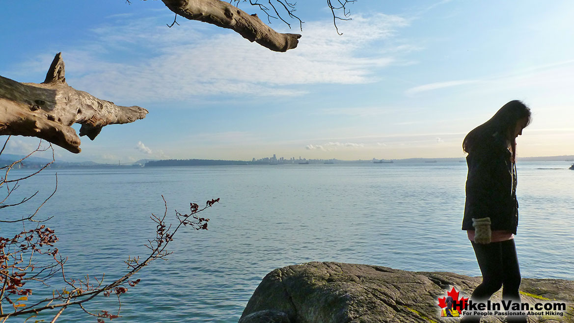
St Mark's Summit is a relatively easy way to get hiking deep into Vancouver's amazing mountains. Starting this hike in Cypress Park means you drive most of the elevation. Even though you still have another somewhat challenging 460 metres in 5.5 kilometres to hike, the beautiful forest and frequent Howe Sound views make it seem quick and easy. Lighthouse Park is gorgeous park with over 10 kilometres of trails through deep forest and along the shore. Just a short drive from downtown Vancouver this park is great to visit all year-round. Another great place to hike just a short drive from downtown Vancouver is the Deep Cove Lookout Trail. The trail crosses numerous creek bridges to get to the impressive lookout with views of Deep Cove and Indian Arm far below. Indian Arm is a 20 kilometre fjord that cuts deep into the mainland. The slopes on either side are heavily forested and steep and therefore have seen little human development as compared to the heavily populated regions nearby. The hike is fairly relaxing at just over 2 kilometres(1.3 miles) from the trailhead to the lookout. There is free parking off Panorama Drive and the trailhead is marked with a Baden Powell Trail sign. The first kilometre sees most of the 160 metre(525 foot) elevation gain and from then on it is a relaxing walk in the woods the the beautiful lookout. Dogs are welcome on the trail and there are washrooms at the parking lot. Deep Cove is a very pretty coastal town full of nice shops and restaurants as well as a nice pier and marina to wander around in. The Lions dominate the skyline in North Vancouver and are easily visible in much of Vancouver. Though hard to believe, the West Lion can be climbed. You don't have to, however, as the plateau before this difficult summit has amazing views. In fact, most finish their hike to The Lions at the wonderful plateau close to the West Lion and looking across to the East Lion. Grouse Mountain is another great area to hike in Vancouver. If you are more into relaxing, you can take the Grouse Mountain Skyride up to all the action. Along with a great network of hiking trails on Grouse, it is also home to two grizzly bears! You can get quite close to them as they lounge in the sun in a special fenced off area on the mountain. Lighthouse Park is an extraordinarily little know piece of paradise, so close to to Vancouver as to see its tall buildings, yet immersed into a dramatically beautiful coastal rainforest. A wonderful network of trails winds throughout massive Douglas-fir trees and Western Red Cedars as well as golden Arbutus trees stretching toward the ocean.
Beautiful Lighthouse Park in Vancouver
St Mark's Summit Tent View

St Mark's Summit View of The Lions

The Lions West Lion Summit Cairn

St Mark's Summit in Vancouver
![]() It takes well under two hours for the average hiker to reach St Mark's Summit and the views are fantastic. Not only because of the incredible vantage point over Howe Sound, but the abruptness of St Mark's Summit. The cliffs below you are frighteningly vertical, making the views fantastically majestic. Also the sheer drop off makes Howe Sound and the speck sized boats seem so surreal. The third and possibly the best feature of the St Mark's Summit hike is the intricately huge and varied terrain on the summit. You stand and marvel at one viewpoint, then moments later your friend appears at an extraordinarily improbable, and worryingly dangerous rock outcrop a few dozen metres away. This hilarious game of hide and seek, seemingly can go on forever. As one leads to another, then another. Over and over, the St Mark's Summit reveals one breathtaking vantage point after another, until you are exhausted more with the views than the hike that got you there. When you estimate your hiking time for St Mark's Summit, be sure to include an hour at least at the top.
It takes well under two hours for the average hiker to reach St Mark's Summit and the views are fantastic. Not only because of the incredible vantage point over Howe Sound, but the abruptness of St Mark's Summit. The cliffs below you are frighteningly vertical, making the views fantastically majestic. Also the sheer drop off makes Howe Sound and the speck sized boats seem so surreal. The third and possibly the best feature of the St Mark's Summit hike is the intricately huge and varied terrain on the summit. You stand and marvel at one viewpoint, then moments later your friend appears at an extraordinarily improbable, and worryingly dangerous rock outcrop a few dozen metres away. This hilarious game of hide and seek, seemingly can go on forever. As one leads to another, then another. Over and over, the St Mark's Summit reveals one breathtaking vantage point after another, until you are exhausted more with the views than the hike that got you there. When you estimate your hiking time for St Mark's Summit, be sure to include an hour at least at the top.
St Mark's Summit View of Howe Sound

More Best Vancouver Hiking - St Mark's Summit
The Lions West Lion Summit
![]() It is beautiful enough, tough, and very rewarding to get to this plateau. To get to The Lions West Lion summit is considerably more challenging and comparatively more rewarding. The view from the top of the West Lion is spectacular. Howe Sound stretches out into the blue distance. A tough but wonderful hike in easy conditions. In wet, cold, or snowy weather, a summit attempt is very treacherous. Not only is cold, snowy, icy or wet weather a consideration due to the slippery footing and hand holds, but also cloudy and foggy weather. Fog can reduce visibility enough to make finding your way, and more importantly, finding your return route, difficult to find. Losing your way from the top of the West Lion has proven fatal in the past. The first half of The Lions Binkert Trail is very easy as you follow a disused, though beautifully overgrown logging road gently uphill. After the first 30 minutes of hiking you come to a Y junction, take the path on the right and continue as the path eventually narrows and beautiful views of Howe Sound become visible.
It is beautiful enough, tough, and very rewarding to get to this plateau. To get to The Lions West Lion summit is considerably more challenging and comparatively more rewarding. The view from the top of the West Lion is spectacular. Howe Sound stretches out into the blue distance. A tough but wonderful hike in easy conditions. In wet, cold, or snowy weather, a summit attempt is very treacherous. Not only is cold, snowy, icy or wet weather a consideration due to the slippery footing and hand holds, but also cloudy and foggy weather. Fog can reduce visibility enough to make finding your way, and more importantly, finding your return route, difficult to find. Losing your way from the top of the West Lion has proven fatal in the past. The first half of The Lions Binkert Trail is very easy as you follow a disused, though beautifully overgrown logging road gently uphill. After the first 30 minutes of hiking you come to a Y junction, take the path on the right and continue as the path eventually narrows and beautiful views of Howe Sound become visible.
The West Lion Summit View

More Best Vancouver Hiking - The Lions West Lion Summit
Beautiful Lighthouse Park
![]() Lighthouse Park is a beautiful Vancouver park, nestled inside a wonderful example of British Columbia's coastal rainforest. The trees are huge, the forest thick and the ocean views are amazing. Rain or shine, this park is a must see on any drive between Vancouver and Whistler. Marine Drive is another aspect that makes this a beautiful detour. This part of Vancouver is a great representation of Vancouver. Deep forest, beautiful ocean and rugged coastline. The first lighthouse was built at Point Atkinson in 1874. The land around it that was to become Lighthouse Park was set aside to provide a dark backdrop for the new lighthouse. The lighthouse you now see was built in 1912. During World War II, search lights and gun emplacements were installed at Point Atkinson to watch over Burrard Inlet. Some buildings from that ere remain along with interesting photos depicting the area during that time.
Lighthouse Park is a beautiful Vancouver park, nestled inside a wonderful example of British Columbia's coastal rainforest. The trees are huge, the forest thick and the ocean views are amazing. Rain or shine, this park is a must see on any drive between Vancouver and Whistler. Marine Drive is another aspect that makes this a beautiful detour. This part of Vancouver is a great representation of Vancouver. Deep forest, beautiful ocean and rugged coastline. The first lighthouse was built at Point Atkinson in 1874. The land around it that was to become Lighthouse Park was set aside to provide a dark backdrop for the new lighthouse. The lighthouse you now see was built in 1912. During World War II, search lights and gun emplacements were installed at Point Atkinson to watch over Burrard Inlet. Some buildings from that ere remain along with interesting photos depicting the area during that time.
Lighthouse Park Sunset

More Best Vancouver Hiking - Lighthouse Park
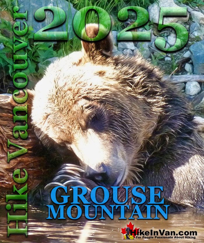
Grouse Mountain in Vancouver
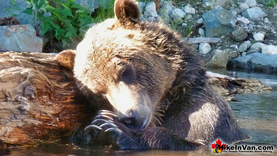
![]() Everyone knows the Grouse Grind as the fantastically popular 2.9k, workout in Vancouver. What is less known is that it is the gateway, or rather back door to some amazing hiking on Grouse Mountain and beyond in Lynn Headwaters Regional Park. Dam Mountain, Goat Mountain, Crown Mountain, Norvan Falls, Coliseum Mountain, Lynn Peak and quite a lot more lay across the horizon from the top of the Grind. Whether you start at the base of the Grind or at the top of the SkyRide, the beautifully addictive Grouse Grind is, for many, just the beginning of the trail to so much more. Lynn Headwaters Regional Park begins several kilometres away at the Lynn Valley trailhead and beautiful trails follow Lynn Creek for 7k to Norvan Falls. The trail then turns into Hanes Valley, connecting to Crown Mountain, Goat Mountain, Dam Mountain and finally leading to Grouse Mountain. The trail from the Lynn Headwaters trailhead to Grouse is about 20k as it carves a giant arc through the valley. Most visitors to Grouse Mountain take the Skyride, an effortless alternative to the Grouse Grind. Another amazing aspect of Grouse Mountain is that it is home to two rescued Grizzly Bears. They wander around a fenced off area of the park, allowing you to get quite close!
Everyone knows the Grouse Grind as the fantastically popular 2.9k, workout in Vancouver. What is less known is that it is the gateway, or rather back door to some amazing hiking on Grouse Mountain and beyond in Lynn Headwaters Regional Park. Dam Mountain, Goat Mountain, Crown Mountain, Norvan Falls, Coliseum Mountain, Lynn Peak and quite a lot more lay across the horizon from the top of the Grind. Whether you start at the base of the Grind or at the top of the SkyRide, the beautifully addictive Grouse Grind is, for many, just the beginning of the trail to so much more. Lynn Headwaters Regional Park begins several kilometres away at the Lynn Valley trailhead and beautiful trails follow Lynn Creek for 7k to Norvan Falls. The trail then turns into Hanes Valley, connecting to Crown Mountain, Goat Mountain, Dam Mountain and finally leading to Grouse Mountain. The trail from the Lynn Headwaters trailhead to Grouse is about 20k as it carves a giant arc through the valley. Most visitors to Grouse Mountain take the Skyride, an effortless alternative to the Grouse Grind. Another amazing aspect of Grouse Mountain is that it is home to two rescued Grizzly Bears. They wander around a fenced off area of the park, allowing you to get quite close!
Grouse Mountain Grizzly Bear
Wonderful Grouse Mountain Sunset

More Best Vancouver Hiking - Grouse Mountain
Hollyburn Mountain in Cypress Park
![]() Hollyburn Mountain, in Cypress Provincial Park, is an amazing place to snowshoe or go hiking. The Hollyburn Mountain trailhead is an astonishingly close, 30 minutes from downtown Vancouver. The 30 minute drive is quite something as well. From the always beautiful crossing of the beautiful Lions Gate Bridge, to the incredible views of Vancouver from the approach drive to Cypress Mountain and the Hollyburn Mountain trailhead. You would almost expect that there would be various fees for parking, trail use, etc. But the Hollyburn Mountain snowshoeing and hiking trail is completely free, and also quite convenient. You will likely be able to park withing a few metres of the hiking/snowshoeing trailhead and if you don't happen to own snowshoes, you can rent them at the trailhead for a very reasonable price. As if it couldn't get better, it does... the trail is so well marked that it can easily be done after dark, as many do. What a perfect escape from the city. Hollyburn Mountain is a perfect escape to a towering mountain paradise far above Vancouver below. The city lights are amazing. From the lights of the Lions Gate Bridge, to the beautifully bright tankers, to the wondrously glowing Vancouver towers.
Hollyburn Mountain, in Cypress Provincial Park, is an amazing place to snowshoe or go hiking. The Hollyburn Mountain trailhead is an astonishingly close, 30 minutes from downtown Vancouver. The 30 minute drive is quite something as well. From the always beautiful crossing of the beautiful Lions Gate Bridge, to the incredible views of Vancouver from the approach drive to Cypress Mountain and the Hollyburn Mountain trailhead. You would almost expect that there would be various fees for parking, trail use, etc. But the Hollyburn Mountain snowshoeing and hiking trail is completely free, and also quite convenient. You will likely be able to park withing a few metres of the hiking/snowshoeing trailhead and if you don't happen to own snowshoes, you can rent them at the trailhead for a very reasonable price. As if it couldn't get better, it does... the trail is so well marked that it can easily be done after dark, as many do. What a perfect escape from the city. Hollyburn Mountain is a perfect escape to a towering mountain paradise far above Vancouver below. The city lights are amazing. From the lights of the Lions Gate Bridge, to the beautifully bright tankers, to the wondrously glowing Vancouver towers.
Hollyburn Mountain is Accessible Year-Round!

More Best Vancouver Hiking - Hollyburn Mountain


