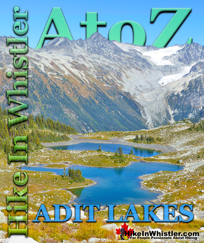
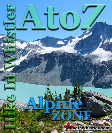
![]() Russet Lake sits in a wide, glacier carved valley at the base of The Fissile. In the direction opposite The Fissile, up on a plateau less than a kilometre away are two small tarns called Adit Lakes. Adit Lakes sit in a broad, boulder strewn alpine zone with an incredible view of Spearhead Range. Just a few metres from Adit Lakes the plateau drops off quickly into the huge valley that separates the Spearhead Range and Fitzsimmons Range.
Russet Lake sits in a wide, glacier carved valley at the base of The Fissile. In the direction opposite The Fissile, up on a plateau less than a kilometre away are two small tarns called Adit Lakes. Adit Lakes sit in a broad, boulder strewn alpine zone with an incredible view of Spearhead Range. Just a few metres from Adit Lakes the plateau drops off quickly into the huge valley that separates the Spearhead Range and Fitzsimmons Range.
Whistler & Garibaldi Hiking
![]() Alexander Falls
Alexander Falls ![]() Ancient Cedars
Ancient Cedars ![]() Black Tusk
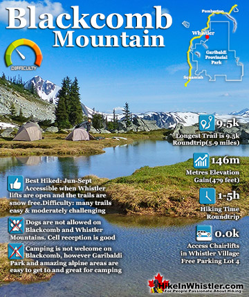
Black Tusk ![]() Blackcomb Mountain
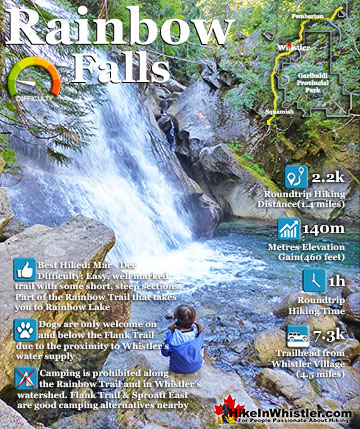
Blackcomb Mountain ![]() Brandywine Falls
Brandywine Falls ![]() Brandywine Meadows
Brandywine Meadows ![]() Brew Lake
Brew Lake ![]() Callaghan Lake
Callaghan Lake ![]() Cheakamus Lake
Cheakamus Lake ![]() Cheakamus River
Cheakamus River ![]() Cirque Lake
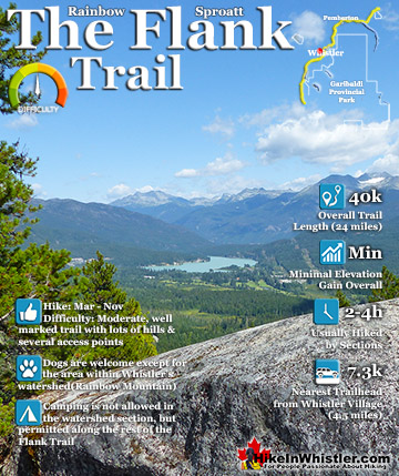
Cirque Lake ![]() Flank Trail
Flank Trail ![]() Garibaldi Lake
Garibaldi Lake ![]() Garibaldi Park
Garibaldi Park ![]() Helm Creek
Helm Creek ![]() Jane Lakes
Jane Lakes ![]() Joffre Lakes
Joffre Lakes ![]() Keyhole Hot Springs
Keyhole Hot Springs ![]() Logger’s Lake
Logger’s Lake ![]() Madeley Lake
Madeley Lake ![]() Meager Hot Springs
Meager Hot Springs ![]() Nairn Falls
Nairn Falls ![]() Newt Lake
Newt Lake ![]() Panorama Ridge
Panorama Ridge ![]() Parkhurst Ghost Town
Parkhurst Ghost Town ![]() Rainbow Falls
Rainbow Falls ![]() Rainbow Lake
Rainbow Lake ![]() Ring Lake
Ring Lake ![]() Russet Lake
Russet Lake ![]() Sea to Sky Trail
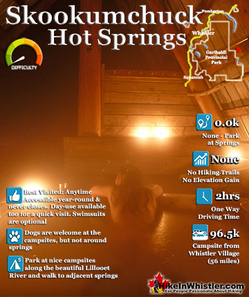
Sea to Sky Trail ![]() Skookumchuck Hot Springs
Skookumchuck Hot Springs ![]() Sloquet Hot Springs
Sloquet Hot Springs ![]() Sproatt East
Sproatt East ![]() Sproatt West
Sproatt West ![]() Taylor Meadows
Taylor Meadows ![]() Train Wreck
Train Wreck ![]() Wedgemount Lake
Wedgemount Lake ![]() Whistler Mountain
Whistler Mountain
![]() January
January ![]() February
February ![]() March
March ![]() April
April ![]() May
May ![]() June
June ![]() July
July ![]() August
August ![]() September
September ![]() October
October ![]() November
November ![]() December
December
The Spearhead Range is named for its jagged array of spearhead shaped peaks that extend to include Blackcomb Mountain. Adit Lakes sit on a plateau in Fitzsimmons Range. From Adit Lakes you can look across the Musical Bumps all the way to the summit of Whistler Mountain. Musical Bumps is the collective name for the series of broad mountain peaks that have musical names. Viewed from Adit Lakes are Oboe Summit, Flute Summit and Piccolo Summit. The Singing Pass trail connects from the Musical Bumps trail and takes you down the valley between Whistler Mountain and Blackcomb Mountain to Whistler Village. The Singing Pass trail runs parallel to Fitzsimmons Creek which Adit Lakes drain into via Adit Creek. Fitzsimmons Creek is named after Jimmy Fitzsimmons who had a small cabin down in the valley near Fitzsimmons Creek. He was a miner that had a mining claim and hoped to find the other end of the copper vein that the Britannia Mine, opened in 1914, sat on. Adit Lakes are evidently named after the word miners use to describe a horizontal mine used to explore for mineral veins. The word adit comes from the latin aditus, which means entrance. Adits are dug into mountain ridges in the hopes of hitting the mineral vein or lode. Fitzsimmons was cutting adits here in the hopes of finding a vein of copper embedded between layers of rock. There are no visible traces of mining around Adit Lakes, but a few kilometres down the Singing Pass trail you can find remnants of old mine shafts.
Little is known about Jimmy Fitzsimmons other than a picture of him from Myrtle Phillip's collection at the Whistler Museum, thought to have been taken in 1916 outside Rainbow Lodge. On the back of the photo is written, "Around 1916, Bill Holloway prospector, Jimmy Fitzsimmons of Fitzsimmons mine. Bill Bailiff, Bill MacDermott, Alex Philip (senior), Tom Wilson, leaving for prospecting trip to Fitzsimmons Glacier area mine."


The Fissile Near Adit Lakes
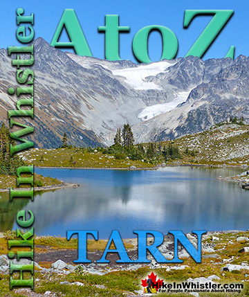
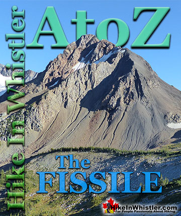
Russet Lake is a surreal little paradise that lays at the base of The Fissile, in Garibaldi Provincial Park. The Fissile is the strikingly bronze mountain visible from Whistler Village. From the Village look into the distance at the Peak2Peak Gondola hanging between Whistler Mountain and Blackcomb Mountain and you will see The Fissile. Its pyramid shape in the distance perfectly separates the two mountains.

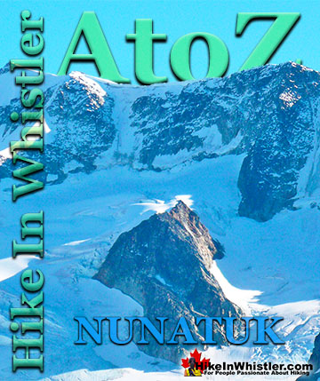
The Fissile is quite a distinct mountain in Garibaldi Provincial Park because of its vivid red colour and symmetrical arrowhead shape. There is another, even more remarkable feature of The Fissile, its age. The sedimentary rock that would eventually become The Fissile was laid down more than 200 million years ago. The Fissile began its life as sedimentary rock formed in a shallow sea along the coast of North America. As tectonic plates pushed into the North American Plate from the Pacific, the Coast Mountains were formed over millions of years. The Coast Mountains are almost entirely comprised of geologically young mountains comprised of volcanic rock as opposed to The Fissile's ancient, crumbling slate. Black Tusk, for example is strikingly youthful at just over a million years old.

Russet Lake Near Adit Lakes
Though Russet Lake is not terribly impressive in terms of size or colour, the valley around it is remarkably beautiful. The colours change from moment to moment in and extraordinary way. The distinctive colour of The Fissile and the stark grey of the mountains around contrast amazingly with the blue of the lake and green grass in the valley. So many different factors fill the place with colour. There are several ways to get to hike Russet Lake. The Singing Pass trail from the base of Whistler Mountain near the Whistler Gondola. The Musical Bumps trail that begins near the top of the Whistler Gondola. Both routes take you deep into the magnificent Fitzsimmons Range. The Fitzsimmons Range runs east from the summit of Whistler Mountain to Russett Lake. Fitzsimmons Creek cuts between Whistler Mountain and Blackcomb Mountain, parallel to the Singing Pass trail. Where the Fitzsimmons Range ends at Fitzsimmons Creek, the Spearhead Range begins and continues along a set of peaks resembling spearheads to Blackcomb Mountain. These peaks include The Spearhead, Mount Trorey, Tremor, Shatter, Shudder, Quiver, and more.


Guides to the Best of Whistler
 Best Dog Friendly Hiking Trails
Whistler is very dog friendly and the number of wonderful hiking trails that your dog will love is huge. The massively varied hiking trails range from easy, short, close to Whistler Village to challenging, long and deep in the endless wilderness around Whistler. You can find dog friendly trails in and around Whistler Village that take you through deep, dark and magical forests. Or you can drive beyond Whistler Village and take your dog to spectacular alpine lakes. Some requiring little or no hiking, while others are found after hiking challenging and long trails. Many of these places are comparatively quiet and often you and your dog will have the the wilderness to yourselves. In and around Whistler Village you have Lost Lake with its spider web of trails... Continued here.
 Best Free Whistler Camping
Whistler is surrounded by an immense wilderness dotted with spectacular, hidden lakes and amazing places to set up a tent. Decades of logging activity has left a network of forest service roads that has opened easy access to these places. Some of these you can drive to and some you may need a 4x4 to comfortably get to. Some places to camp for free you can drive to, some require a short hike and others are fairly long hikes to reach. Beautiful Callaghan Valley is home to several incredible and free places to camp. Callaghan Lake has a great free drive-to campsite just steps from this spectacular alpine lake. If you have a canoe, you can paddle to the end of Callaghan Lake and hike the short, but steep trail up to Cirque Lake. This gorgeous lake is deep in the alpine wilderness... Continued here.
 Northair Mine Murals
Way up in the Callaghan Valley on the back side of Mount Sproatt is an abandoned gold mine. Old cement foundations and two unexpectedly beautiful lakes mark the location of Northair Mine, abandoned in 1982. It was a fairly productive gold mine that extracted five tons of gold. Largely forgotten for years, in the last decade it has come to life in stunning colour by graffiti artists and professional muralists. In the summer of 2013, the first mural appeared on the blank foundation walls of Northair Mine. A creation of a professional Whistler artist PETKO. Painted on one of the inside, pillar walls, the mural is about 8 feet tall and five feet wide of what looks like a robot snake in front of a cube background. It stood out in striking contrast to the grey walls in the background... Continued here.
 Neal Carter Mountaineer
Neal Carter (14 Dec 1902 – 15 Mar 1978) was a mountaineer and early explorer of the Coast Mountains primarily in the 1920’s and 1930’s. Highly skilled as a mountaineer and climber, Carter also excelled at cartography and surveying which he used to map the vast unnamed and unexplored mountains of BC. He named a staggering number of mountains and alpine features, as well as making at least 25 first ascents, many around what we now call the Whistler Valley. Carter began climbing the mountains around Vancouver as a teenager and at the age of seventeen he met someone who would change his life forever. In 1920, while hiking with high school friends Carter had a chance encounter with Tom Fyles, arguably the greatest mountaineer of the era. Continued here.
 Tom Fyles Mountaineer
Tom Fyles (27 June 1887 - 27 March 1979) was an astoundingly skilled climber that figured prominently in the mountaineering community in Vancouver for more than two decades. From his introduction to mountaineering in 1912, to his prolific array of elite level climbing ascents that began in earnest just four years later. In 1916 he solo climbed The Table in Garibaldi Park, a mountain widely considered to be too difficult and dangerous to even attempt. Those that knew him well admired his friendliness, enthusiasm, boundless endurance and incredible ability to read a mountain and navigate the best route to the summit. He made many first ascents and inspired countless new climbers, some becoming giants of the era. Continued here.
More Whistler & Garibaldi Park Hiking A to Z!

The Best Whistler & Garibaldi Park Hiking Trails!
Whistler & Garibaldi Park Best Hiking by Month!


Explore BC Hiking Destinations!

Whistler Hiking Trails

Squamish Hiking Trails

Vancouver Hiking Trails

Clayoquot Hiking Trails
Victoria Hiking Trails

