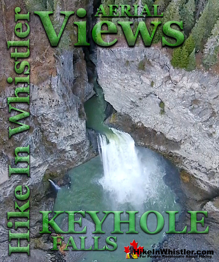
![]() Keyhole Falls are found just a couple kilometres upriver from Keyhole Hot Springs. The unmarked trailhead and parking area for Keyhole Falls are just a couple kilometres past the parking area for Keyhole Hot Springs. If you don't have a rough idea where it is, or expect an obvious sign, you will likely get lost in the maze of logging roads in the area.
Keyhole Falls are found just a couple kilometres upriver from Keyhole Hot Springs. The unmarked trailhead and parking area for Keyhole Falls are just a couple kilometres past the parking area for Keyhole Hot Springs. If you don't have a rough idea where it is, or expect an obvious sign, you will likely get lost in the maze of logging roads in the area.
Whistler & Garibaldi Hiking
![]() Alexander Falls
Alexander Falls ![]() Ancient Cedars
Ancient Cedars ![]() Black Tusk
Black Tusk ![]() Blackcomb Mountain
Blackcomb Mountain ![]() Brandywine Falls
Brandywine Falls ![]() Brandywine Meadows
Brandywine Meadows ![]() Brew Lake
Brew Lake ![]() Callaghan Lake
Callaghan Lake ![]() Cheakamus Lake
Cheakamus Lake ![]() Cheakamus River
Cheakamus River ![]() Cirque Lake
Cirque Lake ![]() Flank Trail
Flank Trail ![]() Garibaldi Lake
Garibaldi Lake ![]() Garibaldi Park
Garibaldi Park ![]() Helm Creek
Helm Creek ![]() Jane Lakes
Jane Lakes ![]() Joffre Lakes
Joffre Lakes ![]() Keyhole Hot Springs
Keyhole Hot Springs ![]() Logger’s Lake
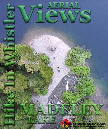
Logger’s Lake ![]() Madeley Lake
Madeley Lake ![]() Meager Hot Springs
Meager Hot Springs ![]() Nairn Falls
Nairn Falls ![]() Newt Lake
Newt Lake ![]() Panorama Ridge
Panorama Ridge ![]() Parkhurst Ghost Town
Parkhurst Ghost Town ![]() Rainbow Falls
Rainbow Falls ![]() Rainbow Lake
Rainbow Lake ![]() Ring Lake
Ring Lake ![]() Russet Lake
Russet Lake ![]() Sea to Sky Trail
Sea to Sky Trail ![]() Skookumchuck Hot Springs
Skookumchuck Hot Springs ![]() Sloquet Hot Springs
Sloquet Hot Springs ![]() Sproatt East
Sproatt East ![]() Sproatt West
Sproatt West ![]() Taylor Meadows
Taylor Meadows ![]() Train Wreck
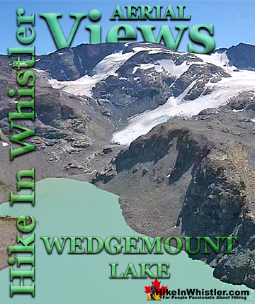
Train Wreck ![]() Wedgemount Lake
Wedgemount Lake ![]() Whistler
Whistler
Whistler Aerial Views
![]() Alexander
Alexander ![]() Brandywine
Brandywine ![]() Blackcomb
Blackcomb ![]() Callaghan
Callaghan ![]() Cirque
Cirque ![]() Joffre
Joffre ![]() Keyhole
Keyhole ![]() Logger's
Logger's ![]() Madeley
Madeley ![]() Panorama
Panorama ![]() Sproatt
Sproatt ![]() Parkhurst
Parkhurst ![]() Rainbow
Rainbow ![]() Russet
Russet ![]() Train Wreck
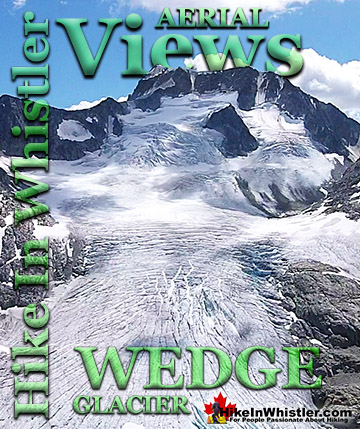
Train Wreck ![]() Wedge Glacier
Wedge Glacier ![]() Wedgemount
Wedgemount ![]() Whistler
Whistler
Mount Meager looms high above Keyhole Hot Springs and it, and the surrounding peaks are known collectively as the Mount Meager Complex. The Meager Complex produced the most recent, major volcanic event in Canada in the last 10,000 years. The eruption 2400 years ago spread ash as far as Alberta. More recently, in 2010 a massive debris flow swept down and into the valley causing Pemberton to be evacuated. The eruption 2400 years ago left a huge pumice outcrop 2 kilometres long and 1 kilometre wide. Keyhole Hot Springs is located 100 kilometres from Whistler(Village Gate Blvd). Though most of the 100 kilometres is on logging roads, it is driveable by most cars without any trouble. The massive Innergex hydroelectric project has turned this once quiet wilderness into a war-zone. On the plus side, the old logging roads near Keyhole Hot Springs and Keyhole Falls are now well maintained and smooth. The hot springs at Keyhole flow out of the ground adjacent to the swirling, crashing and wonderfully glacier coloured water of the Lillooet River. The colour varies with the season, but for the most part it is a wonderful, deep, milky turquoise. When the sunlight penetrates the deep valley, the milky turquoise changes to an unnaturally bizarre, emerald green colour as it swirls all around you. Sitting in the springs you look across to the vertical rock face and the massive, truck sized chunks of it that lay in the river next to you. The Lillooet is fed from various glaciers and snowy mountains visible all the way to Pemberton. At the Lillooet River crossing in Pemberton Meadows take a look in the distance and you will make out the spectacularly jagged and violent looking peak of Mount Meager. It is also a good place to reflect on the fact that Mount Meager produced the larges volcanic eruption in Canada, in the last ten thousand years. It occurred about 2400 years ago and Keyhole and Meager Hot Springs are symptoms of current volcanic activity and another major eruption is possible. In the last couple years BC Ministry of Forests and Recreation Sites and Trails BC have been aggressively blocking public access to both Meager Hot Springs, Keyhole Hot Springs and Keyhole Falls. Currently, in 2023 they have blocked both access roads with gates to the trailheads and are threatening to issue violation tickets. The warning reads: SITE CLOSED: Trail and hot springs are closed from Apr 1 to Nov 15 each year (spring to fall) The Province will be enforcing this closure and will issue violation tickets to anyone caught ignoring the restrictions. They don't appear to have any legitimate reasons for the closures and are clearly making up vague things to justify blocking public access. For example: "The Upper Lillooet provides important habitat for many wildlife species, including the threatened South Chilcotin grizzly bear population, and is a very important wildlife migration corridor for deer, moose, and mountain goats. Mineral licks at the hot springs provide wildlife with year-round nutrients. The hot springs are also home to the vivid dancer damselfly, a species of special concern that is threatened by intensive recreational use. Ad hoc water diversion mechanisms and user created tubs disturb natural features and alter stream flow, negatively impacting the ecosystem. Human activity at the hot springs can displace wildlife from these valuable habitat features."


Keyhole Falls Aerial Views


Meager Slide Debris Field Aerial Views
Meager Hot Springs(aka: Meager Creek Hot Springs) is located 93 kilometres northwest of Whistler, was beautifully developed into gorgeous pools, with a caretaker and usage charge. At its height of popularity, Meager Hot Springs had 30,000 yearly visitors. Unfortunately, due to two recent massive landslides it seems unlikely to ever officially reopen. Below is a picture of Meager Hot Springs in 2009.

Just a decade ago, in 2009, a nice, expensive access bridge was installed. A few months later it was dramatically obliterated from another slide in 2010.


New Access Trail to Meager Hot Springs
In 2014 the new VOC Harrison Hut Trail was cut through the forest, allowing reasonably convenient access to Meager Hot Springs once again. Unfortunately this access road is in a bit of a logging and construction zone, so don't be surprised if the road is blocked by a rock slide or road construction.

The old access bridge over the Upper Lillooet River which cost nearly a million dollars was wrecked in seconds in 2010. There was considerable wrangling and negotiating to get it built in in 2009, but now it will almost certainly never be rebuilt. The area is far too active. Access to the springs is now via the Harrison Trail via the south side of Upper Lillooet River, above and beyond the still visible, still awe inspiring, mudslide carnage. With the catastrophic mud and debris slide let loose from Devastator Peak in 2010, the nice new (in 2009) million dollar bridge to the Meager Creek Hot Springs was destroyed. Though destroyed doesn't even begin to describe it. Looking on the now, dead end road, where the bridge once stood, the place still looks a mess. "Meager Creek FSR is closed indefinitely; no access to the hot springs." This is from the BCParks Upper Lillooet Provincial Park site, and evidently quite accurate.


More info, details, maps and directions to Keyhole Falls
More Whistler Aerial Views!


Whistler & Garibaldi Park Hiking Glossary A to Z
Whistler & Garibaldi Park Best Hiking by Month!


Explore BC Hiking Destinations!

Whistler Hiking Trails

Squamish Hiking Trails

Vancouver Hiking Trails

Clayoquot Hiking Trails
Victoria Hiking Trails

