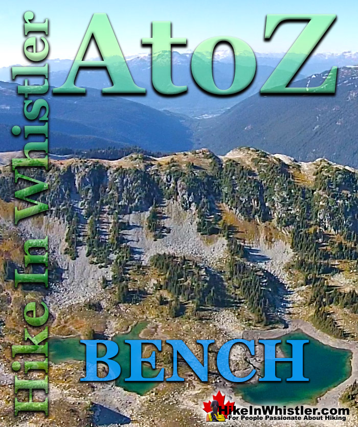
Bench: a flat section in steep terrain. Characteristically narrow, flat or gently sloping with steep or vertical slopes on either side. A bench can be formed by various geological processes. Natural erosion of a landscape often results in a bench being formed out of a hard strip of rock edged by softer, sedimentary rock. The softer rock erodes over time, leaving a narrow strip of rock resulting in a bench. Coastal benches form out of continuous wave erosion of a coastline.
Cutting away at a coastline can result in vertical cliffs dozens or hundreds of metres high with a distinct bench form. Often a bench takes the form of a long, flat top ridge. Panorama Ridge in Garibaldi Provincial Park is an excellent example of a bench. The Musical Bumps trail on Whistler Mountain is another good example of bench formations. Each "bump" along the Musical Bumps trail is effectively a bench. Russet Lake in Garibaldi Provincial Park has a prominent bench adjacent to it. The bench separates Russet Lake and Adit Lakes. Adit Lakes are two idyllic little tarns in a hidden valley separated from the much busier Russet Lake valley by this bench. Towering above Russet Lake is The Fissile, which is visible from Whistler Village in several places. Easy to spot on a clear day if you look up the valley between Whistler Mountain and Blackcomb Mountain, The Fissile is the symmetrical mountain peak in between. The image below is the bench that separates Russet Lake and Adit Lakes and The Fissile in the next image at the far left.
More Whistler & Garibaldi Park Hiking A to Z!
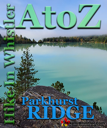
Parkhurst Ridge is an incredible place for a lot of reasons. Of course, the view is spectacular with Green Lake's absurdly vivid green coloured water. ...
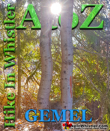
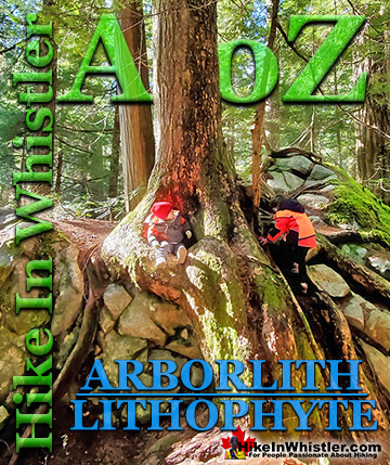
Inosculation is the technical name for two or more trees that have fused together into a single bizarre looking tree. They are colloquially known as ...
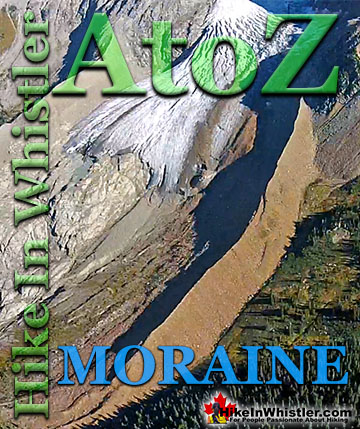
Moraines are glacially deposited ridges of debris that accumulate at the sides or terminus of a glacier. Lateral moraines form at the sides of glaciers ...
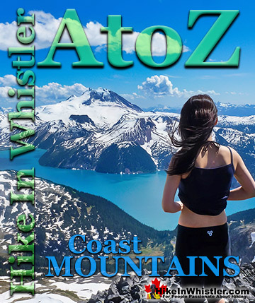
The Coast Mountains run from the Yukon down to Vancouver along the west coast of British Columbia in a band that averages 300 kilometres wide(190 miles). ...
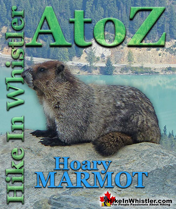
Hoary Marmots are the cute, pudgy, twenty plus pound ground squirrels that have evolved to live quite happily in the hostile alpine areas around Whistler. ...
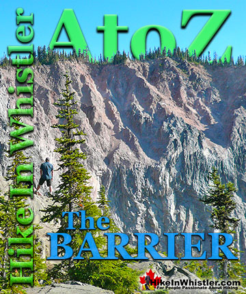
The Barrier formed as a result of huge lava flows from Clinker Peak on the west shoulder of Mount Price during the last ice age. About thirteen thousand ...
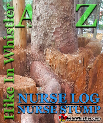
Surprisingly often in Whistler's forests you will find a tree growing on an old fallen tree or out of a decaying tree stump. Decaying logs and stumps in ...
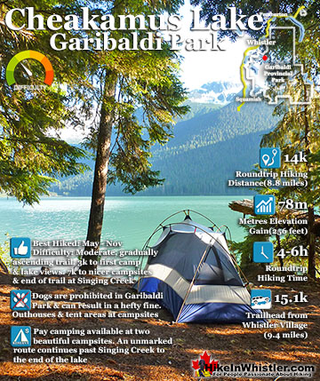
Cheakamus Lake is a wonderfully relaxing way to get in the wilderness easily and quickly from Whistler Village. The trail begins on the far side of Whistler Mountain, 8 kilometres from the Sea to Sky Highway ...
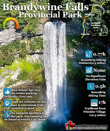
Brandywine Falls is one of the must see sights on the drive to or from Whistler, and arguably the nicest of Whistler’s numerous beautiful waterfalls. Located about halfway between Squamish and Whistler, the ...
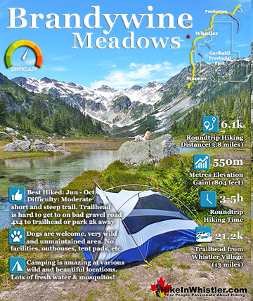
Brandywine Meadows is a nice, relatively short hike to a massive flower filled valley high up in Callaghan Valley. Located 40 minutes south of Whistler, this tough and sometimes muddy trail gains a huge 550 ...
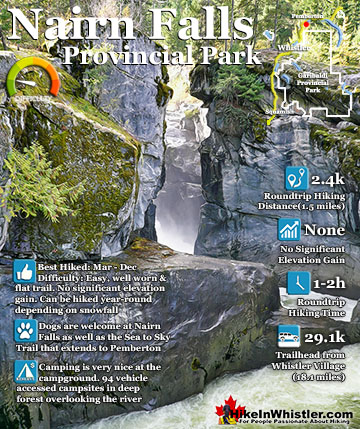
Nairn Falls is a wonderful, crashing and chaotic waterfall that surrounds you from the deluxe viewing platform that allows you to safely watch it from above. The beautiful, green water rushes through the ...
Hiking in Whistler in October is often unexpectedly stunning. The days are much shorter and colder but the mountains are alive with colour from the fall ...
November in Whistler is when the temperatures plummet and the first heavy snow falls in the alpine and often in Whistler Village. The hiking opportunities become ...
December hiking in Whistler is mainly done on snowshoes, though not always. If it hasn't snowed much recently then trails such as Whistler Train Wreck and ...
Hiking in Whistler is spectacular and wonderfully varied. Looking at a map of Whistler you see an extraordinary spider web of hiking trails that are unbelievably numerous. Easy trails, moderate trails and challenging hiking trails are all available. Another marvellous ...
Squamish is located in the midst of a staggering array of amazing hiking trails. Garibaldi Provincial Park sprawls alongside Squamish and up and beyond Whistler. Tantalus Provincial Park lays across the valley to the west and the wonderfully remote Callaghan Valley ...
Clayoquot Sound has a staggering array of hiking trails within it. Between Tofino and Ucluelet, Pacific Rim Park has several wilderness and beach trails, each one radically different from the last. The islands in the area are often Provincial parks on their own with ...
Victoria has a seemingly endless number of amazing hiking trails. Most take you to wild and beautiful Pacific Ocean views and others take you to tranquil lakes in beautiful BC Coastal Rainforest wilderness. Regional Parks and Provincial Parks are everywhere you turn in ...
The West Coast Trail was created after decades of brutal and costly shipwrecks occurred along the West Coast of Vancouver Island. One shipwreck in particular was so horrific, tragic and unbelievable that it forced the creation of a trail along the coast, which ...