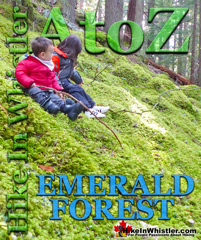
![]() Emerald Forest is a cute little forest that is well hidden between Whistler Cay and Alpine. From Whistler Village, if you go down to the end of Lorimer Road you will see the Valley Trail branch off in three directions. If you take the direction toward Meadow Park, you will immediately cross the bridge over the River of Golden Dreams. The paved trail then continues to Meadow Park, but if you take the first left after crossing the train tracks, you will come to the old gravel pit and the start of the Emerald Forest trails.
Emerald Forest is a cute little forest that is well hidden between Whistler Cay and Alpine. From Whistler Village, if you go down to the end of Lorimer Road you will see the Valley Trail branch off in three directions. If you take the direction toward Meadow Park, you will immediately cross the bridge over the River of Golden Dreams. The paved trail then continues to Meadow Park, but if you take the first left after crossing the train tracks, you will come to the old gravel pit and the start of the Emerald Forest trails.
Whistler & Garibaldi Hiking
![]() Alexander Falls
Alexander Falls ![]() Ancient Cedars
Ancient Cedars ![]() Black Tusk
Black Tusk ![]() Blackcomb Mountain
Blackcomb Mountain ![]() Brandywine Falls
Brandywine Falls ![]() Brandywine Meadows
Brandywine Meadows ![]() Brew Lake
Brew Lake ![]() Callaghan Lake
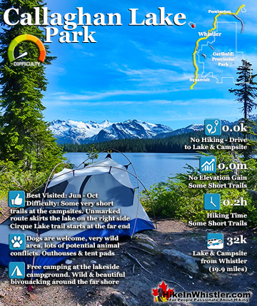
Callaghan Lake ![]() Cheakamus Lake
Cheakamus Lake ![]() Cheakamus River
Cheakamus River ![]() Cirque Lake
Cirque Lake ![]() Flank Trail
Flank Trail ![]() Garibaldi Lake
Garibaldi Lake ![]() Garibaldi Park
Garibaldi Park ![]() Helm Creek
Helm Creek ![]() Jane Lakes
Jane Lakes ![]() Joffre Lakes
Joffre Lakes ![]() Keyhole Hot Springs
Keyhole Hot Springs ![]() Logger’s Lake
Logger’s Lake ![]() Madeley Lake
Madeley Lake ![]() Meager Hot Springs
Meager Hot Springs ![]() Nairn Falls
Nairn Falls ![]() Newt Lake
Newt Lake ![]() Panorama Ridge
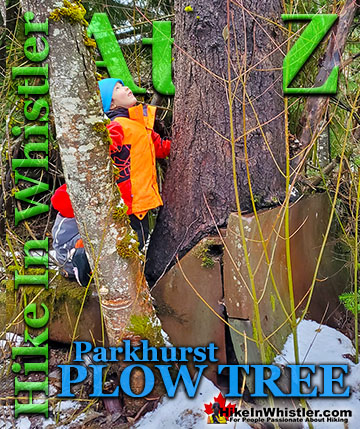
Panorama Ridge ![]() Parkhurst Ghost Town
Parkhurst Ghost Town ![]() Rainbow Falls
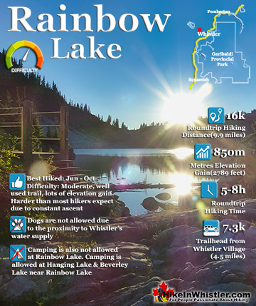
Rainbow Falls ![]() Rainbow Lake
Rainbow Lake ![]() Ring Lake
Ring Lake ![]() Russet Lake
Russet Lake ![]() Sea to Sky Trail
Sea to Sky Trail ![]() Skookumchuck Hot Springs
Skookumchuck Hot Springs ![]() Sloquet Hot Springs
Sloquet Hot Springs ![]() Sproatt East
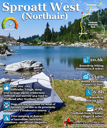
Sproatt East ![]() Sproatt West
Sproatt West ![]() Taylor Meadows
Taylor Meadows ![]() Train Wreck
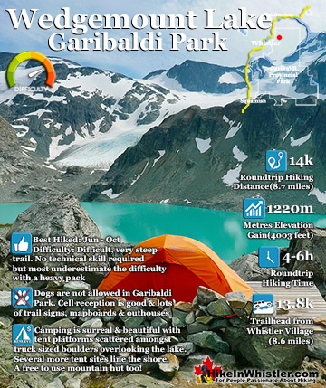
Train Wreck ![]() Wedgemount Lake
Wedgemount Lake ![]() Whistler Mountain
Whistler Mountain
![]() January
January ![]() February
February ![]() March
March ![]() April
April ![]() May
May ![]() June
June ![]() July
July ![]() August
August ![]() September
September ![]() October
October ![]() November
November ![]() December
December
In the winter the gravel pit is a sledding hill and in the summer it is the gateway to a few hiking and biking trails. If you follow the trail up the edge of the gravel pit and look back you will get a great view of Wedge Mountain, Blackcomb Mountain and Whistler Mountain. Unfortunately this view is through power lines, but still the view is fantastic. At the top of the gravel pit you will see two trails that enter Emerald Forest. The first trail takes you through the middle of the forest along a wide and relatively smooth dirt path. This path immediately immerses you in the emerald coloured surrounding of the forest. You immediately understand how the forest got its name as everywhere you look you see green. Green moss on the ground and green trees around and above you. The forest above is so thick that the sun can barely get through. What rays of sun get through light up the green surroundings to illuminate the darkness. This gives Emerald Forest a magical feel to it. It may be a sunny, summer day, yet the forest is surprisingly sealed off from the outside world with the dense forest and thick canopy above. Despite the thick forest cover, walking through the forest is wonderfully bright and actually glows green all around.

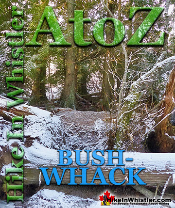
The second entrance takes you along the more rugged and wild ridge trail that takes you roughly parallel, though high above the Valley Trail. This trail zig-zags around fallen trees, boulders and several rock outcrops as well as a couple of small sunny areas with partial views east toward Wedge Mountain. Occasionally this trail meanders into what feels like bushwhacking before rejoining the lower, wider trail that runs through the middle of Emerald Forest. The further you walk from the gravel pit end of Emerald Forest the wilder, more overgrown, and more interesting Emerald Forest becomes. Fallen trees everywhere and strangely out-of-place looking, truck sized boulders force the trails in interesting directions. The terrain is so chaotic with forest growth and boulders that you can often only see a few dozen metres in any direction despite the lack of very much forest floor growth.
This makes the forest quite fun to walk through as you never quite know what you will find around each bend in the trail. Though it is a wonderfully messy spider web of interconnecting trails, you can't get lost for very long. If you start at the gravel pit near Loirmer Road, you will eventually come out at either the Valley Trail on the right or the old gravel road on your left. The old gravel road is the more scenic and serene route to return to where you started. A few decades ago it was a connecting road between Alta Lake Road and Lorimer Road. Now it is a wide and scenic connecting trail that is not very well known. Just before this road connects to Alta Lake Road you will see a trail descend down into the forest on your left. This is the beautifully wild and challenging bike trail know as A River Runs Through It. It traces a fantastically winding route through this deep and dark forest for several kilometres before coming out at Rainbow Park. The old road is the easiest and direct route back to Lorimer Road as it is fairly straight and mostly gradually downhill.


More Whistler & Garibaldi Park Hiking A to Z!

The Best Whistler & Garibaldi Park Hiking Trails!
Whistler & Garibaldi Park Best Hiking by Month!


Explore BC Hiking Destinations!

Whistler Hiking Trails

Squamish Hiking Trails

Vancouver Hiking Trails

Clayoquot Hiking Trails
Victoria Hiking Trails

